Showing posts with label Fishing. Show all posts

Oahu’s Last Fishing Village

SUBHEAD: Mokauea Island's community is threatened by rising seas and pollution and lease with state.

By Natanya Friedman on 11 July 2017 for Civil Beat -
(http://www.civilbeat.org/2017/07/reclaiming-history-oahus-last-hawaiian-fishing-village/)


Image above: Isaiah Longboy, left, assists with cleaning and digging a drainage area after king tides inundated the center part of Mokauea in late June.From ().


Isaiah Longboy lives in Mililani but spends his free time on Mokauea Island, a 13-acre island known as Oahu’s last Hawaiian fishing village. On a recent morning, Longboy helps Kehaulani Kupihea of the

Mokauea Fishman’s Association take canoes full of students from Sand Island to Mokauea on an educational tour. Once on Mokauea, Kupihea tells the students about the island’s tumultuous history.

In the distance, Longboy takes a pickax and digs a channel to drain ocean water flooding the island from high tides.

“I like seeing the progress,” said Longboy, 17, who first visited the island on a field trip with Mililani Middle School. “That’s also why I come out here, seeing the constant progress being made to the island.”

A handful of residents and volunteers, including Longboy, dedicate their time to the island’s cultural and environmental preservation.

It’s not an easy task. Sandwiched between between Honolulu Harbor and Daniel K. Inouye International Airport, the island faces continuous environmental damage from the nearby industrial activity and global warming.

The island often floods during big tides and residents are constantly collecting trash that’s drifted in from Oahu less than a mile away.

Still, for Longboy and others, the island represents a relic of Hawaii’s past that holds lessons for future generations. Printed on the fishermen’s association’s shirt is their motto: The future is in the past.

That future is also uncertain. The hard-fought 65-year lease granted to the island’s residents will end in 26 years, and the state has no firm plans for the island after that.

“I’m really afraid of when the lease does end, are they just going to take it from us and put Matson containers on there?” Kupihea said.


Image above: Kehaulani Kupihea and students from Malama Aina Field School in Nanakuli carry canoes parked on Sand Island into the ocean. Together they will paddle to Mokauea.


An anthropologist and expert on the island, Kupihea takes students, church groups and businesses on excursions to the island.

“It’s not just cleaning a beach, you actually get a history lesson,” she said. “Once you’re connected, you will therefore take care of the place.”

An area rich in both ancient legends and contemporary land rights struggles, Kupihea considers Mokauea and the surrounding area a wahi pana, a legendary place.

Kupihea traces her own lineage to the Mokauea area.

So does Joni Bagood, a resident of the island and one two families who lease land on Mokauea from the state. Bagood’s father was one of a number of families threatened with eviction by the state in the 1970’s.

Today Bagood considers herself the island’s caretaker.

“It’s not what we can get out of her, its what we can do for her,” she said of Mokauea.
.

DAPL battle not over

SUBHEAD: A federal judge ruled an environmental review of the project was inadequate, and ordered it redone.

By Nick Visser on 15 June 2017 for Huffington Post -
(http://www.huffingtonpost.com/entry/judge-dakota-access-pipeline_us_594233bbe4b003d5948d22e7)


Image above: A demonstrator holds a ‘Water Is Life’ sign in front of the White House during a protest against the Dakota Access Pipeline in Washington, D.C. From original article.

A federal judge on Wednesday said an environmental review of the controversial Dakota Access Pipeline was inadequate, handing a last-minute victory to Native American tribes and environmentalists who have long opposed the project.

In a 91-page decision, U.S. District Court Judge James Boasberg said the Army Corps of Engineers, which gave its final approval to the oil project in February, “did not adequately consider the impacts of an oil spill on fishing rights, hunting rights, or environmental justice, or the degree to which the pipeline’s effect are likely to be highly controversial.”

Boasberg ordered the agency to conduct new reviews of those sections of its environmental analysis, but did not halt the use of the pipeline, which began flowing oil on June 1.

The Standing Rock Sioux tribe, which filed the lawsuit, called Wednesday’s decision a “significant victory.”

“The previous administration painstakingly considered the impacts of this pipeline, and President Trump hastily dismissed these careful environmental considerations in favor of political and personal interests,” tribe chairman Dave Archambault said in a statement. “We applaud the courts for protecting our laws and regulations from undue political influence, and will ask the Court to shut down pipeline operations immediately.”

The $3.8 billion, 1,170-mile pipeline has been at the center of an environmental battle for more than a year after thousands of activist, many with Standing Rock, descended on a small region of North Dakota to protest. The monthslong standoff drew international media attention and led the Army Corps of Engineers to pull the plug on the project.

However, just weeks into his presidency, Donald Trump signed an executive order reopening both the Dakota Access and Keystone XL pipelines. Now in operation, at its peak, the Dakota Access pipeline could ship up to 570,000 barrels of oil a day.

The courts have previously rejected legal arguments to shut down the pipeline. Boasberg in February allowed the project to go ahead after siding with its owner, Energy Transfer Partners, over a lawsuit that alleged the pipeline threatened cultural and historic sites.

The judge said he would consider whether the pipeline should shut down while a new environmental review is being conducted at a later time, The Guardian reports.

“This decision marks an important turning point. Until now, the rights of the Standing Rock Sioux Tribe have been disregarded by the builders of the Dakota Access Pipeline and the Trump administration ― prompting a well-deserved global outcry,” Jan Hasselman, an attorney for the group Earthjustice, which represented the Standing Rock Sioux, said in a statement:

“The federal courts have stepped in where our political systems have failed to protect the rights of Native communities.”

See also:
Ea O Ka Aina: Defense contractors fought NoDAPL 5/27/17
Ea O Ka Aina: Tribes divest DAPL Bankers 2/13/17
Ea O Ka Aina: Veterans defending NoDAPL 2/11/17
Ea O Ka Aina: Army Corps okays DAPL Easement  2/8/17
Ea O Ka Aina: Trump orders go on DAPL EIS 2/3/17
Ea O Ka Aina: Water Protectors pipeline resistance 2/1/17 
Ea O Ka Aina: Force a full EIS on DAPL 1/27/17
Ea O Ka Aina: Missile launcher at Standing Rock 1/19/17
Ea O Ka Aina: Lockdown at Trans-Pecos Pipeline 1/10/17
Ea O Ka Aina: Standing Rock has changed us 12/9/16
Ea O Ka Aina: As Standing Rock celebrates... 12/5/16
Ea O Ka Aina: Army Corps denies easement 12/4/16
Ea O Ka Aina: My Whole Heart is With You 12/2/16
Ea O Ka Aina: The Loving Containment of Courage 12/1/16
Ea O Ka Aina: The Beginning is Near 12/1/16
Ea O Ka Aina: Feds to shutdown NoDAPL Camp 11/25/16
Ea O Ka Aina: NoDAPL people are going to die 11/23/16
Ea O Ka Aina: Hundreds of vets to join NoDAPL 11/22/16
Ea O Ka Aina: Obama must support Standing Rock 11/21/16
Ea O Ka Aina: Trump's pro oil stance vs NoDaPL 11/15/16
Ea O Ka Aina: Kauai NoDAPL Demonstration 11/12/16
Ea O Ka Aina: Obama to Betray Standing Rock 11/12/16
Ea O Ka Aina: Trump impact on Standing Rock 11/12/16
Ea O Ka Aina: Ann Wright on Standing Rock 11/8/16
Ea O Ka Aina: Turning Point at Standing Rock 11/6/16
Ea O Ka Aina: Jackson Browne vs DAPL owner 11/5/16
Democracy Now: Boycott of DAPL Owner's Music Festival
Ea O Ka Aina: World responds to NoDAPL protests 11/5/16
Ea O Ka Aina: NoDAPL victory that was missed 11/5/16
Ea O Ka Aina: DAPL hid discovery of Sioux artifacts 11/5/16
Ea O Ka Aina: Dakota Access Pipeline will leak 11/5/16
Ea O Ka Aina: Route of the Dakota Access Pipeline 11/4/16
Ea O Ka Aina: Sanders calls for stopping DAPL 11/4/16
Ea O Ka Aina: Obama hints at DAPL rerouting 11/3/16
Ea O Ka Aina: New military attack on NODAPL 11/3/16
Ea O Ka Aina: How to Support NoDAPL 11/3/16
Unicorn Riot: Tweets from NoDAPL 11/2/16
Ea O Ka Aina: Standing Rock & the Ballot Box 10/31/16
Ea O Ka Aina: NoDAPL reclaim new frontline 10/24/16
Ea O Ka Aina: How far will North Dakota go? 10/23/16
Ea O Ka Aina: Amy Goodman "riot" charge dropped 10/17/16
Ea O Ka Aina: Amy Goodwin to face "Riot Charge" 10/16/16
Ea O Ka Aina: Shutdown of all tar sand pipelines 10/11/16
Ea O Ka Aina: Why Standing Rock is test for Oabama 10/8/16
Ea O Ka Aina: Why we are Singing for Water 10/8/16
Ea O Ka Aina: Labor's Dakota Access Pipeline Crisis 10/3/16
Ea O Ka Aina: Standing Firm for Standing Rock 10/3/16
Ea O Ka Aina: Contact bankers behind DAPL 9/29/16
Ea O Ka Aina: NoDAPL demo at Enbridge Inc 9/29/16
Ea O Ka Aina: Militarized Police raid NoDAPL 9/28/16
Ea O Ka Aina: Stop funding of Dakota Access Pipeline 9/27/16
Ea O Ka Aina: UN experts to US, "Stop DAPL Now!" 9/27/16
Ea O Ka Aina: No DAPL solidarity grows 9/21/16
Ea O Ka Aina: This is how we should be living 9/16/16
Ea O Ka Aina: 'Natural Capital' replacing 'Nature' 9/14/16
Ea O Ka Aina: The Big Difference at Standing Rock 9/13/16
Ea O Ka Aina: Jill Stein joins Standing Rock Sioux 9/10/16
Ea O Ka Aina: Pipeline temporarily halted 9/6/16
Ea O Ka Aina: Native Americans attacked with dogs 9/5/16
Ea O Ka Aina: Mni Wiconi! Water is Life! 9/3/16
Ea O Ka Aina: Sioux can stop the Pipeline 8/28/16
Ea O Ka Aina: Officials cut water to Sioux 8/23/16


.

Impact of Lehua rat poisoning

SUBHEAD: Will the aerial rat poison drop endanger Niihauans and the local fisheries?

By Kawai Warren on 7 June 2017 for Island Breath -
(http://islandbreath.blogspot.com/2017/06/impact-of-lehua-rat-poisoning.html)


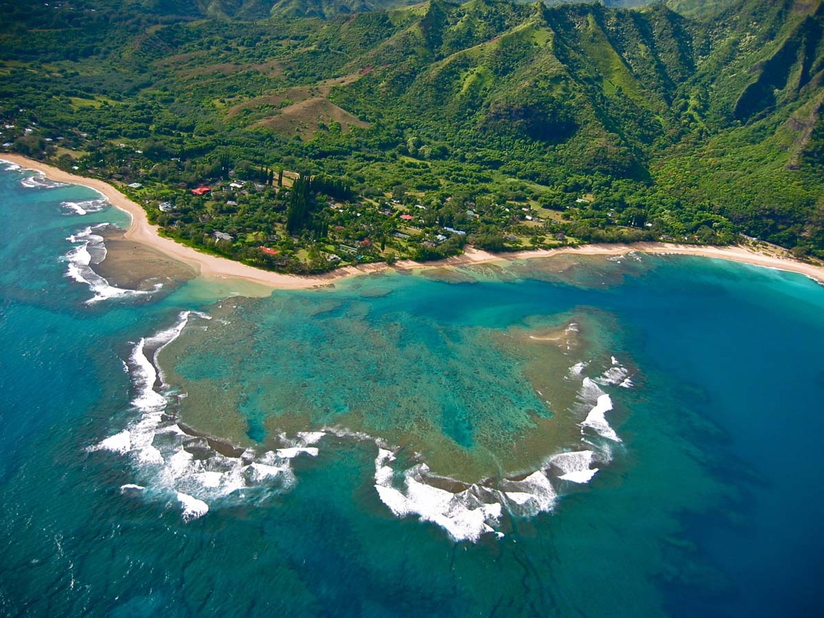
Image above: North-west coast of Lehua Island in foreground with Niihau Island in background. Photo by Juan Wilson on 7/9/11.

I attended the community meeting for the Environmental Assessment Draft in Kekaha. Their was a handful of fisherman that expressed their concern about the side effects of the rat extermination poison and aerial application.

A day after the meeting, we got word that our comments at the meeting were to "do it quickly".

At the meeting I attended in Kekaha no one supported the aerial drop, because the impact it could have on the fisherman, Niihauians, fish, limu, coral, opihi, a' am a, and ocean ecosystems.

The US Fish and Wildlife Service and the Hawaii Department of Land and Natural Resources (DLNR)  are trying to get this done this summer. Unless the fisherman raise their voices and get the media involved. Check out the article below.

Our fisheries (near shore) on the Westside is all ready impacted by these chemicals Atrazine, bentazon, chlorpyrifos, fipronil, metolachlor, propiconazole, and simozine from Kinikini ditch and second ditch during seasonal flooding.


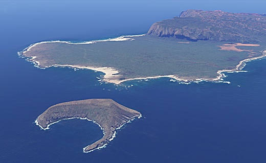
Image above: GoogleEarth 2011 aerial perspective showing proximity of Lehua and Niihau Islands. Same orientation direction as photo above. Only about 4,000 feet separate the two. Image by Juan Wilson.


The Lehua Aerial Poison Drop

SUBHEAD: A risk that the lethal anticoagulant rodenticides could impact the biologically diverse area.


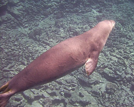
Image above: Photo of monk seal swimming close to shoreline of Lehua Island in shallow water. Photo by Richard Jarke on 7/9/11.

By Maggie Sergio on 7 June 2017 for Huffington Post - 
(http://www.huffingtonpost.com/entry/5936e141e4b033940169ce56)

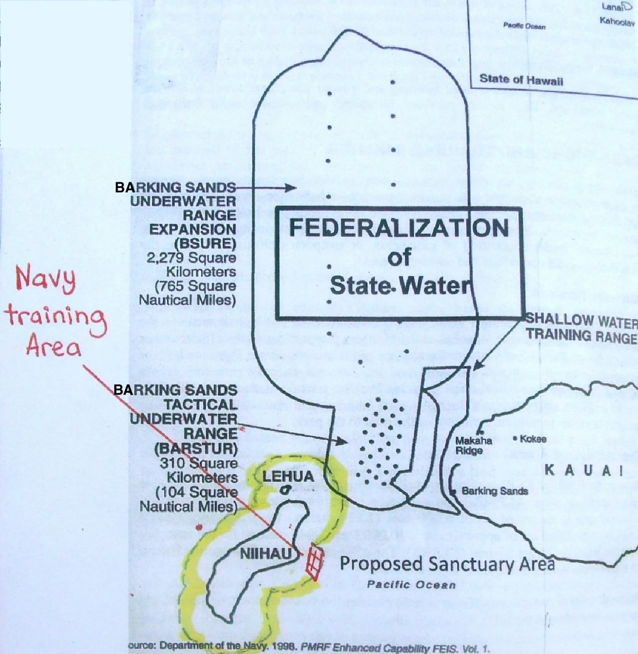
In Hawaii, the Department of Land and Natural Resources (DLNR), and U.S Fish and Wildlife Service (USFWS) are planning several rat poison drops via helicopter onto Lehua Island, located approximately 30 miles west of Kauai.

These drops are being fast-tracked for this summer, part of an eradication project for the 284 acre bird sanctuary.

The planned drop is three-quarter of a mile from an important Native Hawaiian community on Niihau. There is risk that the poison pellets (lethal anticoagulant rodenticides) could impact the biologically diverse and important Lehua Crater.

Sources indicate that DLNR and USFWS are pressuring the State Department of Agriculture to grant permission for the poison bait to be dropped right up to the shoreline, which will result in bait entering the marine environment, allowing the toxins to infiltrate and settle in waters frequented by commercial and Native Hawaiian subsistence fishermen.

The agencies will not disclose or estimate the duration or extent of any fishing bans for tour and recreational boats in surrounding waters. The extent of a ban might be of concern to the local fishing and tour boat communities, given that a 942-day fishing ban was recommended after another Island Conservation poison drop on Wake Island in the in 2012.

If given the green light, the poison drops will happen on Lehua this summer, delivering an estimated 8-10 tons of anticoagulant rodenticide. Birds, fish, monk seals, and other wildlife that consume the cereal-based poison bait either directly or indirectly (secondarily) will be affected, and there is risk of contaminating the food web.

Note: the estimated application rate has been calculated from the amount disclosed on a kg/per hectare basis. Pesticide labels were not included in the draft environmental assessments (EA), so it is unclear if the proposed amount to be dropped is within legal limits.

The Failed 2009 Poison Drop Lehua Controversy
This will be the second poisoning of Lehua in the name of “conservation,” after a failed attempt in 2009. The previous drop was highly controversial—dead fish washed up on the neighboring island of Niihau, and a juvenile whale beached itself.

The state of Hawaii claimed the fish die-off and dead whale were “coincidental” and not related in any way to the nearly four tons of rat poison that had been dropped on the island just days earlier.

After researching the failed event in 2009, which included findings in this presentation given at a national pesticides conference, questions remain about what really happened.

Why was there a two month delay in requesting the fish be tested for exposure to the poison?

Since the rodenticide used in 2009, diphacinone, metabolizes quickly, did the delay in testing capture meaningful results? Are the chain of custody documents available for review?

Could ultra-nutrification and de-oxygenating of the waters, due to the cereal component of the poison bait that entered the surrounding ocean, be a contributing reason for the algae bloom, which, officials claimed, was the cause of the fish kill?

Or, could the poison pellets that entered the marine environment have impacted the fish, not enough to kill them, but enough to cause immunosuppression, thereby making the fish more susceptible to the impacts of an algae bloom? These questions have never been addressed by the agencies.

Are Rats a Problem on Lehua? - Not According to the Data
The data provided in both draft EAs (both the state and feds created a draft environmental assessment) does not support that the rodents on Lehua are having a negative impact on the bird life on the island.

All evidence provided is anecdotal, and astonishingly, USFWS has no idea of the size of the rodent population. One could reasonably ask—since this critical piece of data is unknown—why is this project being fast tracked?

The agencies need to respond to these questions: Why is the collateral damage and potential risk to the food web, in addition to putting sustenance and commercial fishermen in jeopardy, worth the risk? How much consideration was truly given to the Native Hawaiian Ni’ihauans in this accelerated operation, aside from conversations set up and/or attended by the owner of Ni’ihau, the Robinson family?

The only evidence of rodent impact to birds included in the state issued EA shows that four eggs from the nest of a wedge tail shearwater showed indication of predation by rats.

As the wedge tailed shearwater is considered to be a species of least concern by the IUCN (with a worldwide population of over 5 million birds), this hardly constitutes a scientifically-based rationale for dropping 8-10 tons of pesticide, threatening the fragile ecosystem, rare reef system, and food chain.

The DLNR and USFWS have yet to respond to public demands for site-based scientific (vs. anecdotal) evidence on the Lehua rat population, bird decline and mortality causation on Lehua, if any, that justifies this large scale poison drop.

Downplaying Risks  - The Selling of Island Eradication Projects
Both EAs issued mispresent environmental risks, and make misleading statements about the lethal and sub-lethal impacts to wildlife poisoned, which are referred to as “non-target species.”

Though the proposed poisons have never been tested on coral reefs, and the impact is completely unknown, the EA makes the puzzling, badly worded statement on page 73 of the federal EA that “there are no data to indicate corals have been impacted by anticoagulant rodenticides from previous eradication projects.”

Since there are no studies which reflect that rodenticide testing on coral reefs has ever been carried out, and long term, ecosystem monitoring is lacking in eradication projects, the above statement made in the EA could be viewed as disingenuous.

I asked Dr. Mourad Gabriel, who has done extensive research on wildlife diseases, including the impacts of rodenticides on wildlife for his thoughts on the statement specific to coral reefs - his response can be found below.
“The lack of data collected on a topic should not imply that a deleterious impact does not occur.” - Mourad W. Gabriel MS, PhD - Executive Director of Integral Ecology Research Center.
Page 51 of the federal EA cites studies from 1977, 1998, and 1999 with respect to birds eating the poison bait and make the following, false claims:
9. To minimize consumption of bait pellets by shorebirds and terrestrial birds, the bait pellets are dyed a green or blue color, which birds appear to prefer less than yellow or red. 10. Bait pellets are formulated large enough that it would be difficult for a small, seed-eating bird to consume the whole pellet.
The video below, from the New Zealand documentary, “Poisoning Paradise – Eco-cide NZ,” is evidence that color and size of the pellets will not deter birds or other animals from eating them. Deaths of birds poisoned during these projects can occur either directly from eating the bait, or secondarily, by consuming poisoned rodents, insects and fish. Video courtesy of Clyde Graf.

Island Eradications - Previous Problems
Information received from a FOIA request filed in 2014 reveals serious ethical issues from previous eradication projects and shows the consequences of what can go wrong.

Rat Island
In October 2008, USFWS and Island Conservation aerially dropped 51 tons of brodifacoum over Rat Island, located in the Aleutian Islands, and then left for eight months. When they returned, over 400 dead birds were collected, including 46 bald eagles.

Note: the total number of poisoned wildlife counted was by no means the total number of animals poisoned, nor was any long term monitoring done to test for sub-lethal impacts.

In the investigation that followed, U.S. Fish & Wildlife Law Enforcement division reported ten illegal actions including exceeding legal application rates mandated by the pesticide label, failure to properly calibrate dispersion equipment and failure to keep accurate records of their pesticide applications.

You can read a copy of the full USFWS law enforcement report here, released as the result of a FOIA request.

After the investigation by USFWS law enforcement, the Ornithological Council issued this scathing report. You can find a copy of it here.

Wake Island
Located in the South Pacific, Wake Island is host to a military base and is under the jurisdiction of the U.S. Air Force. Wake Island was the recipient of an island eradication attempt in 2012, carried out by Island Conservation and USFWS.

While the almost 20 ton rat poison drop failed to kill all the rats, the more serious issues are the internal emails released in response to the 2014 FOIA request. The discussions between USFWS, the USAF and Island Conservation show that after the fish were tested for brodifacoum, a fishing ban was recommended for 942 days.
FYI – note the Wake Atoll brodifacoum results analysis. We have a couple of options. I guess it comes down to how long we want to restrict consumption of fish at Wake. The current recommendation is approximately 942 days. Also with no money [and] furloughs occurring July 8 – end of September, it is unlikely that a sampling project will occur this FY. I’ll keep you in the loop, but thought you’d might like this info for future projects.” - USAF
You can find the entire email exchange containing the details of the fishing ban recommendation here.

While USFWS and the state of Hawaii assert that no final decision has been made, sources indicate that this project is planned for this summer, and that lead state agencies are awaiting approval from the Hawaii Deptartment of Agriculture (Pesticides Division).

It is notable that some of the supporting state agencies for this poison drop are currently facing a federal investigation charging racial discrimination against Hawaii’s native communities in their lack of care in state pesticide regulation.

The Farallon Islands
This is not the first time that helicopter drops of rodenticides have been called into question. In 2013 a planned rodenticide drop of 1.5 tons of brodifacoum over the Farallon Islands National Marine Sanctuary was halted due to public opposition and heavy questioning into Island Conservation’s conflict of interest in authoring the draft environmental impact statement. 

The city of San Francisco closed their strongly worded letter urging USFWS to seek a partner for the risk assessment that did not have a financial interest in the project.

It remains to be seen whether Hawaii’s impacted communities and scientists will demand fuller disclosure and further study from its agencies and sole-source contractor Island Conservation. For it is Kaua’i’s fishing and tourism industries, and local Hawaiian residents that have the most to lose if anything should go wrong.

In 1962, with the publication of “Silent Spring,” Rachel Carson warned us of the influence the pesticide industry has on agriculture. Fifty-five years later, the dominion of the pesticide industry continues, and non-native species has become another market opportunity to exploit.

.

Determining Kauai's Ala Loa Trail

SUBHEAD: State lawmakers may identify the path of the ancient Ala Loa trail on Kauai as a public trail.

By Timothy Hurley 17 February 2017 for Star Advertiser -
(http://www.staradvertiser.com/2017/02/17/hawaii-news/bill-aims-to-settle-disputes-over-trail-on-kauai/)


Image above: Photo looking west along the Kalaloa Trail on the north shore of Kauai. This section of the overall Ala Loa Trail system is still in everyday use. From (http://islandbreath.blogspot.com/2015/11/kauais-ala-loa-trail.html).

[IB Publisher's Note: To follow and comment on this legislation see (http://www.capitol.hawaii.gov/measure_indiv.aspx?billtype=HB&billnumber=120&year=2017)]

State lawmakers are weighing a bill that requires the state to identify the path of the ancient Ala Loa trail on Kauai and recognize it as a public trail.

The trail, which generally follows the coast around the island, apparently includes a section that crosses the property of Facebook CEO Mark Zuckerberg as well as other oceanfront property owners reluctant to open their land.

More than 100 people marched near Zuckerberg’s property Feb. 4 in what was billed as a peaceful demonstration to “Save the Ala Loa” and urge that it be opened to the public. Some were Native Hawaiians looking for coastal access for fishing and gathering purposes.

The bill, introduced by state Rep. Kaniela Ing, is expected to be approved on second reading today by the House Committee on Ocean, Marine Resources and Hawaiian Affairs and then move on to the House Committee on Water and Land.

The measure was approved Tuesday despite a request by state Department of Land and Natural Resources Chairwoman Suzanne Case that it be deferred.

In written testimony, Case said that while the department, through its Na Ala Hele trail and access program, has determined from registered maps that the trail is owned by the state, the problem is that the exact location still remains undetermined.

“To date the department has not been able to confirm the location of this historic trail — indeed evidence indicates it may have been located further mauka away from the coast near the main highway,” she said.

Nevertheless, officials remain committed to an ongoing dialogue with community members regarding specific trail locations, and the department is continuing to review “all available information” in an effort to determine the trail’s whereabouts, Case said.

But Jocelyn Doane, public policy director for the Office of Hawaiian Affairs, said more than enough information is available to pinpoint what she called a “critical cultural pathway.”

Doane said officials with OHA and the Native Hawaiian Legal Corp., along with community members in the Koolau district of North Kauai, have been working on the issue since 2011.

“Through this work and the great work of the community, OHA believes that the specific scope and location of the Ala Loa extending through the Koolau district has in fact been thoroughly documented,” Doane said.

The historic trail appears on maps from as early as 1833 through 1900 and is recognized in land commission award documents that date back to the Great Mahele, the land distribution of 1848.

What’s more, ancient coastal settlements in the Koolau district such as Moloaa, Papaa and Aliomanu were traditionally linked by the Ala Loa, she said, and accounts of the use of this historic trail have been documented in publications from 1829 to 1895.

Doane said she walked portions of the trail with community members only two weeks ago.

“There’s no question they know exactly where the Ala Loa is,” she said.

The state’s authority to claim ownership of ancient trails dates back to when Queen Lili‘uokalani and the legislature of the kingdom of Hawaii enacted the Highways Act of 1892, a law that still remains on the books.

Under the law, all roads, trails, bridges and other forms of public access that can be verified to have existed before 1892 continue to be owned in fee simple by the state.

The law applies even if the trail is not physically on the landscape, having, for example, been wiped out from ongoing land use activities or by natural events. But the burden of proof rests with the state, which must consider archaeological reports, historic maps, historic accounts, surveyor’s notes, deeds and other sources of information that might help determine state ownership.

In written testimony, Kauai County Councilman Mason Chock said identifying and recognizing the trail would be an important step in securing public-access, hunting and gathering rights for many Native Hawaiians.

It would also help end the escalating tension between Native Hawaiians, private landowners and residents in regard to its location, Chock said.

Some residents have complained about fences blocking access, security guards patrolling beaches and fishermen being threatened with arrest.

See also:
Ea O Ka Aina: Modest Disruption will unravel us 11/25/15
Ea O Ka Aina: No need for $7m from state 11/12/15
Ea O Ka Aina: Kauai's Ala Loa Trail 11/6/15
Ea O Ka Aina: The Toxic Truth 4/18/14
Ea O Ka Aina: The Ala Loa Trail 4/10/14
Ea O Ka Aina: Trails and Tribulations 2/26/13
Ea O Ka Aina: Sleeping with the Enemy 5/24/11
Ea O Ka Aina: Paradise Ranch Rationalization 2/16/11

.

Sea Shepherd patrols Atlantic

SUBHEAD: In partnership with marines from Gabon the Sea Shepherd boarded and commandeered boat with illegal catch. 

By Peter Hammarstedt on 9 August 2016 for Sea Shepherd Global -
(http://www.seashepherdglobal.org/news-and-commentary/news/operation-albacore-results-in-detention-of-spanish-long-liner-in-sao-tome.html)


Image above: A 2006 photo of the Sea Shepherd ship "Bob Barker". From (http://teakdoor.com/world-news/115479-japan-wont-go-awhaling-year-cant-6.html).

On the 6th of August, the Spanish long-line fishing vessel Alemar Primero was boarded in waters belonging to the Central African island state of São Tomé and Príncipe by São Toméan authorities, assisted by Sea Shepherd crew and law enforcement officers from Gabon.

Although the long-liner was licensed to fish for 'tuna and similar species' inspections revealed that their fish holds were filled with sharks, predominately blue sharks that are classified as 'near-threatened' by the IUCN.

Many of the shark's fins had already been detached from their bodies, a suspected violation of the European Union Finning Ban (1185/2003) and its amendment (605/2013), which requires sharks to be landed with their Fins Naturally Attached (FNA).

São Toméan authorities ordered the long-liner to retrieve their fishing gear, release their catch and proceed to São Tomé for investigation. With four marines remaining on board for security, the long-liner was escorted to São Tomé by the Sea Shepherd vessel M/Y Bob Barker.

On the 7th of August, the Alemar Primero arrived in the fishing village of Neves where it will remain, pending investigations, while the M/Y Bob Barker resumes patrols.

Since April 2016, under the name Operation Albacore, Sea Shepherd has been assisting the Government of Gabon to tackle Illegal, Unreported and Unregulated (IUU) fishing by providing the use of the M/Y Bob Barker as a civilian offshore patrol vessel operating in Gabonese waters, under the direction of the Gabonese Government.

In August São Tomé and Príncipe partnered with Operation Albacore, sending two marines and one fisheries observer from São Tomé to join Sea Shepherd crew, Gabonese marines and Gabonese fisheries enforcement officers on board the M/Y Bob Barker, to further detect and deter IUU fishing in the Gulf of Guinea.

Sea Shepherd Global was established in 1977, Sea Shepherd is an international non-profit, marine wildlife conservation organization. Our mission is to end the destruction of habitat and slaughter of wildlife in the world's oceans in order to conserve and protect ecosystems and species.

Sea Shepherd uses innovative direct-action tactics to investigate, document, and take action when necessary to expose and confront illegal activities on the high seas. By safeguarding the biodiversity of our delicately-balanced ocean ecosystems, Sea Shepherd works to ensure their survival for future generations. For more information, visit: (http://www.seashepherdglobal.org)


.

Renewing Relatives

SUBHEAD: Indigenous people of Great Lakes restore nme` sturgeon species as key to environmental health.

By Holtgren, Ogren, Whyte on 13 November 2015 -
(http://www.earthisland.org/journal/index.php/eij/article/renewing_relatives)


Image above: Illustration of Nme` byYevgenia Nayberg. From original article.

For centuries, the ancestors of the Little River Band of Ottawa Indians, an Anishinaabe people of the Great Lakes region, gathered on the banks of the Big Manistee River every spring to celebrate the annual return of a revered fish to its age-old spawning grounds.

So ancient is this fish species, and so deeply intertwined is it with the tribe’s culture and survival, that the Anishinaabek sometimes call it the “grandfather fish.” But usually tribal members refer to the fish, which has been around since dinosaurs roamed the earth, as nmé. When the colonizers arrived, they renamed nmé “lake sturgeon.”

For many generations this massive, gray-white colored fish – which can reach up to six feet or more in length, weigh more than 150 pounds, and live up to 150 years – served the Anishinaabek as a substantial food source. “The grandfather fish would sacrifice itself so the people would have food [during the lean seasons] until the other crops were available,” says Jay Sam, the historic preservation officer of the Little River Band of Ottawa Indians, who live in what is now Michigan and within whose lands the Big Manistee River watershed lies.

Nmé populations in different parts of the rivers and streams also were aligned with clan-spirit and identity.

“There were different places on the river that were set for sturgeon clans,” says Jimmie Mitchell, the tribe’s director of natural resources.

Just as Anishinaabe families today are descendants of generations of Anishinaabek from this region, so too are surviving nmé today the descendants of those who interacted with the very same families generations ago. The fish was so important to the traditional culture that Anishinaabe leaders would sign documents with nmé images.

Before the colonizers arrived, nmé could be found in lakes and rivers all the way from Canada to Alabama, and were abundant in the basins of the Great Lakes, Hudson Bay, and Mississippi River. Regardless of this abundance, the Anishinaabek maintained a conservative approach to their harvesting practices, ever mindful that the balance of nature is in a constant state of change.

But that wasn’t the way of settlers, who initially killed nmé as a nuisance by-catch because the bottom-feeding (or benthic) sturgeon damaged their fishing gear.

Then, in the latter half of the nineteenth century, as lake sturgeon meat and eggs became prized, they trapped and killed nmé in even larger numbers. According to the US Fish and Wildlife Service, between 1879 and 1900 the Great Lakes commercial sturgeon-fishing fleet caught an average of 4 million pounds of fish per year.

This kind of overharvesting, along with other factors – such as clearcut logging practices, stocking rivers with nonnative fish species for sport fishing, environmental pollution, and dams that blocked nmé from returning to their natal streams and rivers to spawn – led to a drastic decline in nmé populations.

 By the early 2000s, only about 40 to 50 fish a year returned to spawn in the Big Manistee River and many historic nmé rivers lost their populations completely. Nmé came back to the river, not as a healthy component of either the river or tribal culture, but weakened, embattled, and imperiled.

Today, nmé are at less than 1 percent of their historic numbers and are listed as either threatened or endangered by 19 of the 20 states within their original range. In many ways, especially to settler Americans, nmé became a forgotten fish.

For the Anishinaabek, the nmé’s reduced runs meant the gradual erosion of a system of symbiotic living and the many traditions associated with it. “Decline of the sturgeon has corresponded with decline in sturgeon clan families,” says Kenny Pheasant, a culture carrier who teaches Anishinaabemowin, the language of the Anishinaabe, to people throughout the Great Lakes region. “Only a few sturgeon clan families are known around here.”

But there’s hope. During the past decade, a unique restoration effort by the Little River Band of Ottawa Indians has helped bolster nmé populations in the Big Manistee watershed, and revive their cultural and ecological connection to their nonhuman kin.

After the US reaffirmed its “recognition” of the Little River Band of Ottawa Indians as a sovereign nation in 1994, the tribe used its new government status to formalize natural resource stewardship and environmental protection programs.

Restoring relatives such as nmé is a central part of that.
Yet restoring nmé using the Indigenous conception of stewardship was not easy.

Some people in the Manistee area believed that tribal people did not desire to live sustainably. They believed that treaty rights were unfair to settler Americans.

The state of Michigan questioned tribal efforts for nmé restoration, claiming that the Little River Band of Ottawa Indians did not have the legal authority to engage in restoration work. Many local residents thought it was a waste of time and money to restore a fish that might take 100 years to recover fully.

In short, settler Americans did not understand Anishinaabe culture. They did not understand the Anishinaabe concept of sustainability, which is based on maintaining the relationships connecting humans, plants, animals, and the land. It’s a concept we call baamaadziwin, which in the Anishinaabemowin language means “living in a good and respectful way.”

Baamaadziwin, Mitchell explains, motivates people to go beyond being good and just “to being servants, devoting ourselves to making a difference in all that has occurred and may still be occurring within our respective communities and environment.” This, he says, “includes restoring the balance of our shared natural environment and of all inhabitants who are dependent upon a robust ecosystem.”

Despite the resistance from settler Americans, the tribe stubbornly persisted in its nmé restoration efforts, deeming it a sacred responsibility. The tribe was convinced that by reclaiming the nmé’s rightful place within the watershed, balance would be restored to the river’s other nonhuman kin. So tribal members and biologists crafted the “LRBOI Sturgeon Stewardship Plan.”

The plan envisioned a holistic management approach that would address the numerous threats to not only the watershed, but to the Great Lakes Basin as a whole. Although aimed at rehabilitating and reclaiming nmé, it also provided for the health and improvement of the animals, plants, and people living within the watershed.

The Sturgeon Program launched in 2001 and a year later the tribe successfully documented natural reproduction of lake sturgeon by capturing newly hatched nmé larvae (fry) from the Big Manistee River. In 2004, the Little River Band of Ottawa Indians established the first portable streamside rearing facility where young nmé collected from the river in spring were nurtured and protected until the fall, when they were released back into the same river.

This was the first time the technique had ever been used for lake sturgeon. Its success was especially important because this technique kept the fish “home” during rearing and because maintaining the genetic makeup of nmé populations in different rivers is crucial for the Anishinaabek, whose traditional beliefs include specific relationships between particular families and their local fish populations.

This idea also supports the principles of conservation biology, which seeks to maintain the unique genetic attributes of each river’s nmé population.

Since 2004, another five streamside facilities based on the same design have been set up within the Lake Michigan Basin. The tribe’s Nmé Stewardship Plan is now a guiding document for nmé restoration in the Great Lakes, and it has changed how the region’s fisheries are managed today. Many agencies, including the US Fish and Wildlife Service and the states of Michigan and Wisconsin, now collaborate with the tribe’s sturgeon program.

The success of the restoration program can be measured not only by the number of reared sturgeon in the Great Lakes, but in the changed the relationship between the settler Americans in the Manistee area and the Anishinaabek. Fishing guides, who previously were suspicious of the restoration initiatives, have begun voluntarily helping locate sturgeon.

Outfitters educate their clients about the importance of nmé and tribal stewardship. Settler Americans are now happy to see the tribal biologists on the river. The Little River Band of Ottawa Indians is no longer simply seen as a “casino tribe,” but as a nation doing distinctive work in the region based on Anishinaabe culture and science.

The watershed community now views nmé as a species whose presence makes the Manistee area special. The fish has been able to both heal old wounds and create new, sustainable, relationships among people, even in a watershed where these relationships have been strained by settler colonialism.

Now, every September hundreds of people – Native as well as settler – gather by the banks of the Big Manistee River to release young nmé into the waters with much fanfare, ceremony, and feasting. Each person cups a young sturgeon in his or her hand and gently guides it back to the river. A lasting connection is built between fish and human.

Most non-Natives present at the ceremony are probably not ready to adopt the Anishinaabe way of thinking about the world and our place in it. But in that moment of release they embrace a sense of themselves linked to a watershed shared with their nonhuman kin.

• Marty Holtgren and Stephanie Ogren are former staff of the Little River Band of Ottawa Indians. Kyle Whyte (Potawatomi) is a professor of environment philosophy and ethics at Michigan State University.


.

Fishing subsidies killing oceans

SUBHEAD: While not all subsidies are bad, some are pushing us in a race to fish out the oceans.

By Rashid Sumaila on 18 October 2015 for the Conversation -
(https://theconversation.com/the-race-to-fish-how-fishing-subsidies-are-emptying-our-oceans-48227)


Image above: Alaskan halibut commercial fishing operation in Pacific Ocean in May 2011. From (http://www.pacificfishing.com/Archives/week_of_050911pf.html).

Fish numbers are rapidly dwindling globally, and fishery subsidies are one of the key drivers behind this decline. In 2009, these subsidies totalled about US$35 billion, creating incentives for fishers around the world to increase their catch. But this short-term “race to fish” is jeopardising the long-term environmental, social, and economic security that fisheries offer us all.

My group at the University of British Columbia recently cast our net into the troubling waters of fishery subsidies, to see how this ship might be turned around.

Overfishing is major issue facing our oceans

sh (those species used by humans for subsistence or commercial purposes) have fallen by half in the four decades from 1970 to 2010. A full 90% of fish stocks globally are now classified as either over exploited or fully exploited. Common seafood choices such as tuna, shrimp, whiting, and salmon are among the worst affected.

Only the very deepest parts of the oceans are currently safe from the pressure of fisheries. But how long this remains the case is yet to be seen. The demand for fish is growing the world over, driven by population growth, increased wealth, and the continued mass subsidization of the fisheries industry.

Fishing subsidies are a global problem

The US$35 billion of subsidies that we estimate that were handed out globally in 2009 is not trivial. In fact, this figure constitutes between 30% and 40% of the landed values generated by marine fisheries worldwide.

To understand their full impact, though, it is useful to divide these subsidies into three broad categories:
  • Subsidies for management and research – considered as “good” subsidies because they generally have a positive effect on our ability to manage fishery resources sustainably for the benefit of all generations.
  • Capacity-enhancing (or harmful) subsidies – for example, construction and fuel; these tend to promote the overexploitation of fish stocks by motivating overcapacity and overfishing.
  • Ambiguous subsidies – such as those to vessel buy-back programs and rural fisher community development, can either promote or undermine the sustainability of fish stocks depending on how they are designed and implemented.
Our research found that capacity-enhancing, or harmful subsidies made up nearly 60% of the total; fuel subsidies alone (arguably the most capacity-enhancing) constituted about 22% of the total. Ports and harbors received a 10% share.

Meanwhile, subsidies provided for fishery management totaled only 20% globally. In Australia, we estimated these “good” subsidies similarly comprised about 29% of Australia’s total subsidies to fisheries.

Developed countries provided twice the amount of subsidies as developing countries, although the latter group lands about 80% of global fish catch.

In terms of national contributions, Japan provided the highest amount of subsidies (13% of the global total), followed closely by China (12.9%) and the United States (11.7%). Australia’s fishing subsidises came in at 1.4% of the global total.

The impacts of fishing subsidies

Although the direct impact of subsidies on fish resources depends on the health of the fish stock and the strength of management in place, fisheries management is rarely completely effective. In fact, there is evidence that subsidies alone can undermine efforts to manage stocks sustainably.

Commercial fishing enterprises are profit-driven, meaning the more profits that can be made the more fishing will typically take place. Because capacity-enhancing subsidies increase profits artificially, they are stimulating this “race to fish” within the industry. This is having disastrous consequences for many fish populations.

Fishery subsidies are also having socioeconomic, distributional, and trade impacts. They not only distort the market for fish, but often disadvantage fishers who receive relatively less subsidies.
In fact, most subsidies go to the large-scale industrial fishers in developed nations, rather than small-scale developing country fishers. This represents a barrier to development in precisely the regions where it is most needed.

What can be done about harmful subsidies?

Improving transparency is a fundamental requirement for reducing harmful fishing subsidies. Transparency around these subsidies could stimulate action, not only by revealing the scale of the problem, but also by providing a solid data-set that governments can use to implement reform. An important goal is to shift from “harmful” to “good” subsidies, which would go a long way to ensuring the money remains in fishing communities.

To make real progress in curtailing capacity-enhancing subsidies, it is important to develop and implement a multi-scale multi-stakeholder approach. Efforts must be made at the national, regional, and global levels of governance. Ultimately, these efforts should lead into a multilateral agreement at the World Trade Organization.

At the local level, we need to build political will to tackle the short-sightedness of our economic and political systems.

One step towards achieving this would be to develop a cadre of local opinion leaders who understand the benefits of eliminating capacity-enhancing subsidies. Supporting these domestic advocates for change could prove to be a crucial foundation stone for the building of a sustainable global fishery industry.

.

Fukushima Radiation Contamination

SOURCE: Ray Songtree (rayupdates@hushmail.com)
SUBHEAD: Two years ago birds were found with patches of white feathers related to their radiation exposure.

By Juan Wilson on 13 October 2015 for Island Breath.org -
(http://islandbreath.blogspot.com/2015/10/fukushima-radiation-contamination.html)


Image above: Slide from presentation of Ken Buesseler on impact of radiation entering the ocean in Japan and on the US west coast.

Ray Songtree emailed me a link to a video of Dr. Tim Mousseau's presentation on the biological impacts of the Chernobyl and Fukushima nuclear power plant meltdown disasters. It was an excellent report as part of a three part video presentation produced by the Ecological Options Network (EON).

We are these videos in reverse order, beginning with Beth Brangan's of EON "Neither Panic nor Denial", followed by Tim Mousseau's "Bio-Impacts of Chernobyl & Fukushima", and finishing with Ken Buesseler's "Fukushima from Two Sides of the Pacific".


Neither Panic nor Denial

By Mary Beth Brangan on 2 September 2015 for EON -
(https://youtu.be/TiKp2iZ4_z0)


Video above: Presentation by Beth Brangan of "Neither Panic nor Denial".

"EON's Mary Beth Brangan sums up an evening of presentations on Fukushima contamination by independent research scientists Ken Buesseler, of Woods Hole Oceanographic Institution, and Tim Mousseau, Department of Biological Sciences, University of South Carolina.

Brangan explains why the independent scientific evidence so far strongly supports applying the Precautionary Principle in crafting the appropriate public policy response to radioactive fallout from the on-going Fukushima nuclear disaster in Japan.

She calls for international solidarity with the plight of dispossessed & exploited Fukushima refugees, and the explosive, youth-led current Japanese grassroots campaign against the militarism and nuclear brinkmanship of the US-supported Abe regime.

She encourages people to support independent research scientists' projects and to join the growing movement to shut down California's own 'Fukushima-in-Waiting,' PG&E's aging Diablo Canyon, located over 13 intersecting earthquake faults, in a tsunami zone not far south of San Francisco - the state's 'last nuke standing.'

Organizer: Bing Gong
Co-Sponsors: Fukushima Response Campaign, Pt. Reyes Books, EON

For more info:
http://www.eon3.net/
OurRadioactiveOcean.org
www.biol.sc.edu/faculty/mousseau
MothersForPeace.org
FoE.org
NoNukesCA.net
Fukushima Responce Campaign on Facebook


Bio-Impacts of Chernobyl & Fukushima

By Dr. Tim Mousseau on 2 September 2015 for EON -
(https://youtu.be/5xnj5QYBzLs)


Video above: Presentation by Tim Mousseau of "Bio-Impacts of Chernobyl & Fukushima".

Evolutionary biologist Dr. Tim Mousseau shares findings from his unique research on the biological effects of radiation exposure to wildlife from the nuclear disasters at Chernobyl & Fukushima.

This is part 2 of a 3-part series of presentations on Fukushima contamination by independent research scientists Ken Buesseler, of Woods Hole Oceanographic Institution, and Tim Mousseau, Department of Biological Sciences, University of South Carolina.


 Fukushima from Two Sides of the Pacific

By Dr. Ken Buesseler on 2 September 2015 for EON -
(https://youtu.be/pIqs5rUo8Qs)


Video above: Presentation by Ken Buesseler of "Fukushima from Two Sides of the Pacific".

[EON Editors' note: This relatively unconcerned stance of Buesseler's appeared to change a bit the week after this talk when he spoke in Canada after the Japanese typhoon caused massive flooding. https://www.youtube.com/watch?v=zaXKL...... ]

Marine biologist Dr. Ken Buesseler, is Senior Scientist at the Woods Hole Oceanographic Institute's Center for Marine and Environmental Radioactivity.

Introduced by Mary Beth Brangan, Co-Director of EON, Dr. Buesseler reviews his findings so far in his on-going citizen-funded project monitoring the continuing radioactive contaminiation from japan's Fukushima triple nuclear meltdown.

Within months of the Fukushima disaster, Ken Buesseler assembled an international research cruise to sample the waters surrounding the nuclear plant.

To date, important fisheries remain closed due to cesium levels above Japanese limits for seafood. Ocean currents are bringing the radioactive particles released from Fukushima to the West Coast.

Buesseler now monitors over 50 sites along the West Coast, from Alaska to Mexico, with citizen-scientist funding and participation.

In june of 2014 off the coast of northern California and April 2015, in Ucluelet BC, radioactive cesium from Fukushima was detected in ocean water samples.
.

Commercial fish numbers down 50%

SUBHEAD: Some commercial fish stocks such as tuna, have fallen by almost 75% since 1970s.

By Andy Campbell on 16 September 2015 for the Huffington Post -
(http://www.huffingtonpost.com/entry/crucial-marine-populations-cut-in-half-since-the-1970s-report_55f9ecd2e4b00310edf5b1b2)


Image above: Jumping yellowfin tuna (Thunnus albacares) in Maldives, Indian Oceana. From original article .

A disturbing new report published by the World Wildlife Fund (WWF) found that the world marine vertebrate population declined by 49 percent between 1970 and 2012.

The Living Blue Planet Report -- analyzed by the Zoological Society of London (ZSL) and issued as an update on our oceans' health -- also found that local and commercial fish populations have been cut in half, tropical reefs have lost nearly half of their reef-building coral, and there are 250,000 metric tons of plastic in our oceans. The WWF reported in a press release;
"Global climate is one of the major drivers causing the ocean to change more rapidly than at any other point in millions of years . These findings coincide with the growing decline of marine habitats, where the deforestation rate of mangroves exceeds even the loss of forests by 3-5 times; coral reefs could be lost [to temperature rises] across the globe by 2050; and almost one-third of all seagrasses have been lost."
Populations of some commercial fish stocks, such as a group including tuna, mackerel and bonito, had fallen by almost 75 percent, according to the study.

Marco Lambertini, director general of WWF International, told Reuters mismanagement was pushing "the ocean to the brink of collapse.".

"There is a massive, massive decrease in species which are critical," both for the ocean ecosystem and food security for billions of people, he said. "The ocean is resilient but there is a limit."

The analysis said it tracked 5,829 populations of 1,234 species, such as seals, turtles and dolphins and sharks. It said the ZSL data sets were almost twice as large as past studies.

"This report suggests that billions of animals have been lost from the world's oceans in my lifetime alone," Ken Norris, director of science at the ZSL, said in a statement. "This is a terrible and dangerous legacy to leave to our grandchildren."

Damage to coral reefs and mangroves, which are nurseries for many fish, add to problems led by over-fishing. Other threats include coastal development, pollution and climate change, which is raising temperatures and making waters more acidic.

The study said the world's fishing fleets were too big and supported by subsidies totaling $14-35 billion a year.

World marine fish catches dipped to 79.7 million metric tons in 2012 from 82.6 million in 2011, according to the U.N.'s Food and Agriculture Organization. Safeguarding the oceans can help economic growth, curb poverty and raise food security, it says.


.

Haena Subsistence Fishing

SUBHEAD: Hawaii Governor Ige signs bill supporting Haena Community-Based Subsistence Fishing Area.

By Leo Azambuja on 5 August 2015 for ForKauai -
(http://www.forkauaionline.com/ige-signs-haena-community-based-subsistence-fishing-area-into-law-w-video/S)

http://www.islandbreath.org/2015Year/08/150805haenabig.jpg
Image above: Aerial photo of Haena Point and its coral reef formation is an especially rich aquatic environment. Click to embiggen. From (http://www.dreampusher.com/kauai-august2005/).

Gov. David Ige has signed into law the Community-Based Subsistence Fishing Area for Haena, Kauai. The state of Hawaii’s first CBSFA was filed Tuesday, according to the state Department of Land and Natural Resources.

The result of years of discussions and collaboration between the Haena community and various stakeholders, this historic rules package gives the Ha‘ena hui an opportunity to protect its ocean resources, based on traditional fisheries management practices.

“The Haena CBSFA is an outstanding example of self-determination and governance for a local community, which wants to not only preserve but enhance its local fishery for sustainability,” Ige said in a DLNR press release. “I personally want to thank everyone involved for their patience and kokua in bringing this long process to a great conclusion.”

The rules for the Haena CBSFA were approved by the state Board of Land and Natural Resources last October. DLNR will hold a public hearing on the Ha‘ena CBSFA Management Plan at a later date.

“Community based management of this nature isn’t only the past, but is now the future,” DLNR Chair Suzanne Case said. “This CBSFA reflects the hard work and commitment of the greater Haena community and provides a great example of how other communities and the state can collaborate to manage precious natural resources.”

The Ha‘ena CBSFA is the result of more than a decade of work, overwhelming support from the local community and strong recognition that government cannot do it alone and community-based management and buy-in is critical to sustaining natural resources now and for future generations.


Thomas Hashimoto, a respected master in fishing and agriculture practices was born and raised in Ha‘ena. He is also a founding member of Hui Makaainana o Makana, a nonprofit formed in 1999, which advocated for the creation of the Ha‘ena CBSFA.

“The land and the ocean are life for the people. In Haena, from my great-grandparents time, we were taught to malama Haena, its lands, and especially its ocean areas,” Hashimoto said. “I have been honored and humbled to share knowledge I received from my kupuna from past generations with all who live in Ha‘ena, so these same places that I have fished and gathered my whole life will continue to be here for my great-grandchildren and all future generations.”

.

Too many fish in the sea?

SUBHEAD: Fukushima radiation will cause long-term harm to Pacific Bluefin Tuna and Pacific Pink Salmon.

By Admin on 16 June 2015 for ENE News -
(http://enenews.com/study-fukushima-will-result-marked-lasting-decrease-population-pacific-salmon-efforts-needed-protect-species-possible-extinction-continued-monitoring-will-be-critical-avoidance-health-problems-h)


Image above: Pink salmon, shown spawning in Alaska, have increased since the 1970s, with an estimated 640 million returning to their breeding rivers in Asia and North America in 2009 alone. Now the species population is in collapse. In the long run, are the Fukushima meltdowns going to conserve or destroy fish in the Pacific Ocean? From (http://news.nationalgeographic.com/news/2014/03/140331-salmon-seabirds-pacific-fish-animals-science/).

Study: Fukushima radiation will cause long-term harm to Pacific salmon population — Efforts needed to protect species from possible extinction — Radiation monitoring is critical to avoid human health problems — “US inland areas also at risk of exposure”

Journal of Applied Mathematics — Modelling the Effects of Radioactive Effluent on Thunnus orientalis and Oncorhynchus gorbuscha, New Jersey City Univ. (Chen, Ding, Laracuenti, Lipat (Columbia Univ., NASA Goddard Institute for Space Studies)), 2013 (bold emphasis added):
  • The contamination of the Pacific Ocean by the radioactive pollutants released from the Fukushima Daiichi Nuclear Power Plant has raised legitimate concerns over the viability of marine wildlife. We… explore the extent of the effects of the radioactive effluent on two marine species: the Pacific Bluefin Tuna and the Pacific Pink Salmon…

  • Because of the brevity of the period of time during which radioactive material was discharged… [it's] assumed to be instantaneous [note the study was released before TEPCO admitted the flow of radioactive material into the Pacific never ended]…

  • This pollution was spread through the entire Pacific Ocean…

  • A numerical solution… will simulate the effects of the Fukushima Daiichi nuclear disaster… This simulation has far-reaching implications for decisions related to the location of nuclear power plants as well as to fishing policy…

  • According to data released by Tepco, the initial concentrations of radioactivity following the release of 11,500 metric tonnes of contaminated water into the Pacific Ocean… are 310,000 Bq/L of iodine-131, 230,000 Bq/L of caesium-134, and 230,000 Bq/L of caesium-137 [which] produces the initial radioactivity of the iodine-131: 3.57 trillion Bq… caesium-134: 2.65 trillion Bq… caesium-137: 2.65 trillion Bq [note that estimates by gov't scientists are 10,000+ times higher]…

  • Analysis of the results shows that the Pacific Bluefin Tuna will experience a steeper population decline in the short term compared to its expected population decline… after which the population will return to the expected population.

  • Pacific Pink Salmon, on the other hand, will simply decline at a faster pace than the expected population declineradioactive effluent will result in a marked and lasting decrease in population [see Fig. 5, 6]…

  • Before the conclusions are subjected to social analysis, the model’s limitations must be considered… the model does not reflect the migratory nature of both fish species. This does not, however, entirely negate the validity of the simulation: over a sufficiently long period of time, the short-term movement of the fish throughout the Pacific Ocean becomes negligible… The results of the model… opt to consider the fish species’ population on average…

  • The very high rate of decline of the Pacific Pink Salmon indicates that live specimens may contain relatively high levels of radioactivity. Continued monitoring of the Pacific Pink Salmon, as well as all marine species, for radioactivity will be critical to the avoidance of health problems for humans. Because the species migrates throughout freshwater rivers and tributaries of British Columbia, Alaska, and the Pacific Northwest of the United States, inland areas are also at risk of exposure to, at the very least, low-level radioactivity. Moreover, the rapid rate of decline of the Pacific Pink Salmon, in conjunction with rapidly deteriorating conditions, seems to necessitate drastic action. Work beyond sustainability is needed to protect the species from possible extinction

  • Because of the deleterious effects on the marine environment… it seems reasonable to suggest that any new nuclear power plants be constructed sufficiently far from coastal waterways so as to mitigate the absorption of any radioactive contaminants into the biosphere. This, however, would pose a risk to the environment near the nuclear power plant without the capacity of an ocean to diffuse the radioactivity…

  • The authors are thankful to [National Science Foundation award] NSF HRD-0902132 (LSAMP) for the support to do this research.
See also: Scientists: Radioactivity in food web off Pacific Northwest to “significantly increase” — Salmon forecast to exceed Japan radiation limit — “Major concern for public health”

.

Another USA Pacific territorial grab?

SUBHEAD: Yes, yes. We know it's to save the whales. Just like the US Navy Range is to protect us from the Chinese.

By Juan Wilson on 18 May 2015 for Island Breath -
(http://islandbreath.blogspot.com/2015/05/another-usa-pacific-territorial-grab.html)

http://www.islandbreath.org/2015Year/05/150518niihaubig.jpg
Image above: Map showing proposed Whale Sanctuary boundary around Niihau in yellow. Note it just encloses an offshore Navy training area and overlaps the Barking Sands Underwater Range Expansion area - thus blocking north south passage between Niihau and Kauai under some circumstances. Click to enlarge. From poster on a bulletin board at Salt Pond Store in Hanapepe that urged interested parties make comment on sanctuary expansion.

It has been called the Asian Pivot by talking heads, pundits and political flacks. It seemed it was going to be the final chapter in the westward expansion of America across the world. I suppose it began with the taking of Hawaii and the Spanish American War and was fulfilled World War Two in the Pacific: then perpetuated with the atmospheric nuclear tests through the fifties and began degrading with the Vietnam debacle and subsequent defeat.

 It is my opinion that American expansion of authority in the Pacific Ocean may have crested. There seems to be an increased skepticism and resistance to claims by America of open ocean and island nations despite our "historic victories" and newer assertions.

Note that as dedicated, environmentally aware and scientific some National Oceanic and Atmospheric Administration staff are, that NOAA is a subsidiary of the Commerce Department and is responsible for administering commercial fishing throughout American territories in the Pacific (including Hawaii) through through the Western Pacific Regional Fisheries Council (WESPAC).

In recent decades the military ranges, marine sanctuaries and monuments that the Navy and NOAA administer have grown and overlapped alarmingly.

This is happening to such an extent that we are creating a contiguous area that claims millions of square miles of the Pacific (that include dozens of strategic islands) - an area that would be hard for any navigator to avoid sailing into.

(http://www.islandbreath.org/2014Year/10/141022uspivotbig.jpg
Image above: The elliptical boundary of the Pacific Remote Islands Marine National Monument shown overlapping the testing area of the Pacific Missile Range Facility on Kauai. Click to enlarge (http://www.islandbreath.org/2014Year/10/141022uspivotbig.jpg).

As an example of difficult navigation just look at the overlapping ellipses that make up the newly proposed Pacific Remote Islands Marine National Monument (or PRIMNM). It encompasses approximately four-million square miles of the Pacific Ocean and several islands used as nuclear barbeque pits in decades past. The perimeter of this area is area bounded by no less than seven overlapping ellipses.

It you were a sailor or fisherman who needed to avoid the area of the PRIMNM you would find that such curves are impossible to circumnavigate with traditional techniques. They require a constantly changing compass heading. It is much easier to navigate around a rectangular or rectilinear shape with sides made up of lines of latitude or longitude. Just bear a constant North, South, East or West.

So when the Obama Administration proposed the current marine national monument expansion of the PRIMNM the RAMNM (Rose Atoll Marine National Monument 90,000 sq miles), the MTMNM (Marianna Trench Marine National Monument 1,000,000 sq miles) and the PMNM (the Papahanaumokukea Marine National Monument 1,300.000 sq miles) you might wonder how they generated elliptical boundaries. I think I know the answer. It is a lesson in how detached and out of touch the US government is to reality on the ground (or on the sea).

I believe some hustling anonymous assistant to a committee made up of military brass, Commerce Department honchos and Obama administration aides was tasked with showing the proposed monument areas on a map of the Pacific Ocean. 

That assistant was  provided a jpg file  by the Defense Department of our military test ranges in the Pacific. The assistant used his/her PC to open the file with CorelDRAW and preceded to use the application's ellipse drawing tool to surround the proposed monument areas under consideration with overlapping ellipses following the instruction from "Now to Make Hippos using CorelDRAW".


Image above: A step in the instructions for drawing a hippo (and Pacific Remote Islands Marine National Monument boundaries) with CorelDRAW. From (http://www.duniamedia.com/coreldraw/how-to-make-hippos-using-coreldraw.html).

As you may know, now the US Federal Government is proposing expanding the Hawaiian Islands Humpback Whale National Marine Sanctuary (HWNMS). The areas making up the sanctuary would be administered by the National Oceanic and Atmospheric Administration (or NOAA) and include the whole state.

When  Kauai fishermen, indigenous Hawaiians, and sovereignty advocates got wind of the plan they put together a six-page resolution endorsed by some 6,000 Kauai ocean users who oppose to the expansion of the HWNMS. This was presented to the Kauai County Council for approval. The Council, in a typical act of political cowardice, deferred the item until October.
See TGI here (http://thegardenisland.com/news/local/whale-wars/article_3e14e102-83cb-11e2-917a-001a4bcf887a.html) 3/3/15

There were public meetings conducted by NOAA to present the expansion plan to Hawaiian residents. The meetings were packed with interested members of the public and did not go well for Sanctuary Superintendent  Malia Chowin her presentation.

The meetings were rauckus and on occasion profane. Many members of the public were suspicious and angry. See TGI here (http://thegardenisland.com/news/local/first-sanctuary-meeting-draws-fire/article_b45a7a96-f388-11e4-ac4b-4786d5f0d807.html) 3/27/15.

One upshot is that the HWNMS expansion presentation scheduled for today on Oahu has been cancelled by NOAA with this statement of their website (http://hawaiihumpbackwhale.noaa.gov/)
"The Sanctuary Advisory Council Meeting that was scheduled for May 18, 2015 at the Pagoda Hotel in Honolulu has been cancelled. Stay tuned for the rescheduled meeting date."
I guess it is time to reassess the public relations of this Humpback Whale Sanctuary. You can submit testimony on this issue at (http://hawaiihumpbackwhale.noaa.gov). You have until June 19th 2015 to comment. Also you can write our governor. An example from the bulletin board at Salt Pond Store is below.


To: Office of the Governor
The Honorable David Y. Ige
Executive Chambers of the State Capital
Honolulu, Hawaii, 96813


I am in opposition to the proposed document Hawaii Island Humpback Whale National Marine Sanctuary: Expansion, Regulatory Revision and New Management Plan for the following reasons.

• The expansion of the Sanctuary is not justified or warranted.

• There is no justification for the proposal to move from a single species humpback whale sanctuary to managing everything in the ecosystem

• Federalization of State waters is not needed.

• The Environmental Impact Statement does not identify management gaps that need to be filled to enhance the conservation and protection of Hawaii's natural resources.

• The proposed rule clearly duplicates existing State and Federal management authority and regulations. See Appendix 4 of the Humpback Whale Sanctuary Draft Environmental Impact Statement.

• NOAA has proposed to delist the Humpback Whale from the Endangered Species list.

• The existence of the Whale Sanctuary is not justified in State waters. I am opposed to all Federal Sanctuary proposals in Hawaii.

Mahalo from

Name:

Date:

Address:


.