SUBHEAD: Yes, yes. We know it's to save the whales. Just like the US Navy Range is to protect us from the Chinese.
By Juan Wilson on 18 May 2015 for Island Breath -
(http://islandbreath.blogspot.com/2015/05/another-usa-pacific-territorial-grab.html)
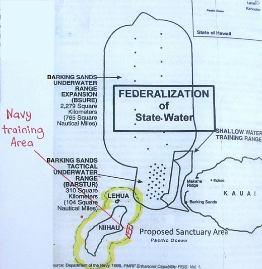
Image above: Map showing proposed Whale Sanctuary boundary around Niihau in yellow. Note it just encloses an offshore Navy training area and overlaps the Barking Sands Underwater Range Expansion area - thus blocking north south passage between Niihau and Kauai under some circumstances. Click to enlarge. From poster on a bulletin board at Salt Pond Store in Hanapepe that urged interested parties make comment on sanctuary expansion.
It has been called the Asian Pivot by talking heads, pundits and political flacks. It seemed it was going to be the final chapter in the westward expansion of America across the world. I suppose it began with the taking of Hawaii and the Spanish American War and was fulfilled World War Two in the Pacific: then perpetuated with the atmospheric nuclear tests through the fifties and began degrading with the Vietnam debacle and subsequent defeat.
It is my opinion that American expansion of authority in the Pacific Ocean may have crested. There seems to be an increased skepticism and resistance to claims by America of open ocean and island nations despite our "historic victories" and newer assertions.
Note that as dedicated, environmentally aware and scientific some National Oceanic and Atmospheric Administration staff are, that NOAA is a subsidiary of the Commerce Department and is responsible for administering commercial fishing throughout American territories in the Pacific (including Hawaii) through through the Western Pacific Regional Fisheries Council (WESPAC).
In recent decades the military ranges, marine sanctuaries and monuments that the Navy and NOAA administer have grown and overlapped alarmingly.
This is happening to such an extent that we are creating a contiguous area that claims millions of square miles of the Pacific (that include dozens of strategic islands) - an area that would be hard for any navigator to avoid sailing into.

Image above: The elliptical boundary of the Pacific Remote Islands Marine National Monument shown overlapping the testing area of the Pacific Missile Range Facility on Kauai. Click to enlarge (http://www.islandbreath.org/2014Year/10/141022uspivotbig.jpg).
As an example of difficult navigation just look at the overlapping ellipses that make up the newly proposed Pacific Remote Islands Marine National Monument (or PRIMNM). It encompasses approximately four-million square miles of the Pacific Ocean and several islands used as nuclear barbeque pits in decades past. The perimeter of this area is area bounded by no less than seven overlapping ellipses.
It you were a sailor or fisherman who needed to avoid the area of the PRIMNM you would find that such curves are impossible to circumnavigate with traditional techniques. They require a constantly changing compass heading. It is much easier to navigate around a rectangular or rectilinear shape with sides made up of lines of latitude or longitude. Just bear a constant North, South, East or West.
So when the Obama Administration proposed the current marine national monument expansion of the PRIMNM the RAMNM (Rose Atoll Marine National Monument 90,000 sq miles), the MTMNM (Marianna Trench Marine National Monument 1,000,000 sq miles) and the PMNM (the Papahanaumokukea Marine National Monument 1,300.000 sq miles) you might wonder how they generated elliptical boundaries. I think I know the answer. It is a lesson in how detached and out of touch the US government is to reality on the ground (or on the sea).
I believe some hustling anonymous assistant to a committee made up of military brass, Commerce Department honchos and Obama administration aides was tasked with showing the proposed monument areas on a map of the Pacific Ocean.
That assistant was provided a jpg file by the Defense Department of our military test ranges in the Pacific. The assistant used his/her PC to open the file with CorelDRAW and preceded to use the application's ellipse drawing tool to surround the proposed monument areas under consideration with overlapping ellipses following the instruction from "Now to Make Hippos using CorelDRAW".

Image above: A step in the instructions for drawing a hippo (and Pacific Remote Islands Marine National Monument boundaries) with CorelDRAW. From (http://www.duniamedia.com/coreldraw/how-to-make-hippos-using-coreldraw.html).
As you may know, now the US Federal Government is proposing expanding the Hawaiian Islands Humpback Whale National Marine Sanctuary (HWNMS). The areas making up the sanctuary would be administered by the National Oceanic and Atmospheric Administration (or NOAA) and include the whole state.
When Kauai fishermen, indigenous Hawaiians, and sovereignty advocates got wind of the plan they put together a six-page resolution endorsed by some 6,000 Kauai ocean users who oppose to the expansion of the HWNMS. This was presented to the Kauai County Council for approval. The Council, in a typical act of political cowardice, deferred the item until October.
See TGI here (http://thegardenisland.com/news/local/whale-wars/article_3e14e102-83cb-11e2-917a-001a4bcf887a.html) 3/3/15 By Juan Wilson on 18 May 2015 for Island Breath -
(http://islandbreath.blogspot.com/2015/05/another-usa-pacific-territorial-grab.html)
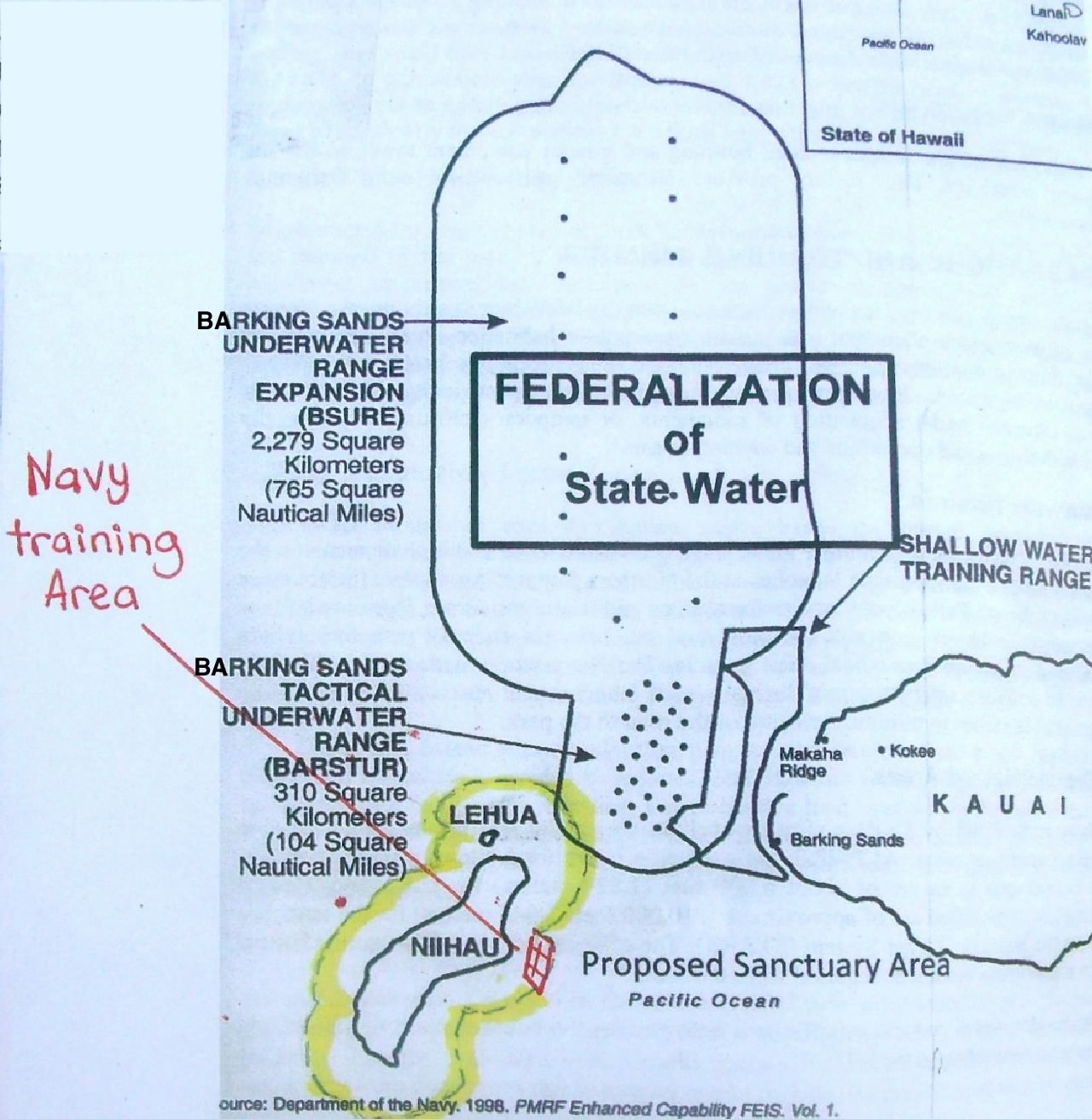
Image above: Map showing proposed Whale Sanctuary boundary around Niihau in yellow. Note it just encloses an offshore Navy training area and overlaps the Barking Sands Underwater Range Expansion area - thus blocking north south passage between Niihau and Kauai under some circumstances. Click to enlarge. From poster on a bulletin board at Salt Pond Store in Hanapepe that urged interested parties make comment on sanctuary expansion.
It has been called the Asian Pivot by talking heads, pundits and political flacks. It seemed it was going to be the final chapter in the westward expansion of America across the world. I suppose it began with the taking of Hawaii and the Spanish American War and was fulfilled World War Two in the Pacific: then perpetuated with the atmospheric nuclear tests through the fifties and began degrading with the Vietnam debacle and subsequent defeat.
It is my opinion that American expansion of authority in the Pacific Ocean may have crested. There seems to be an increased skepticism and resistance to claims by America of open ocean and island nations despite our "historic victories" and newer assertions.
Note that as dedicated, environmentally aware and scientific some National Oceanic and Atmospheric Administration staff are, that NOAA is a subsidiary of the Commerce Department and is responsible for administering commercial fishing throughout American territories in the Pacific (including Hawaii) through through the Western Pacific Regional Fisheries Council (WESPAC).
In recent decades the military ranges, marine sanctuaries and monuments that the Navy and NOAA administer have grown and overlapped alarmingly.
This is happening to such an extent that we are creating a contiguous area that claims millions of square miles of the Pacific (that include dozens of strategic islands) - an area that would be hard for any navigator to avoid sailing into.
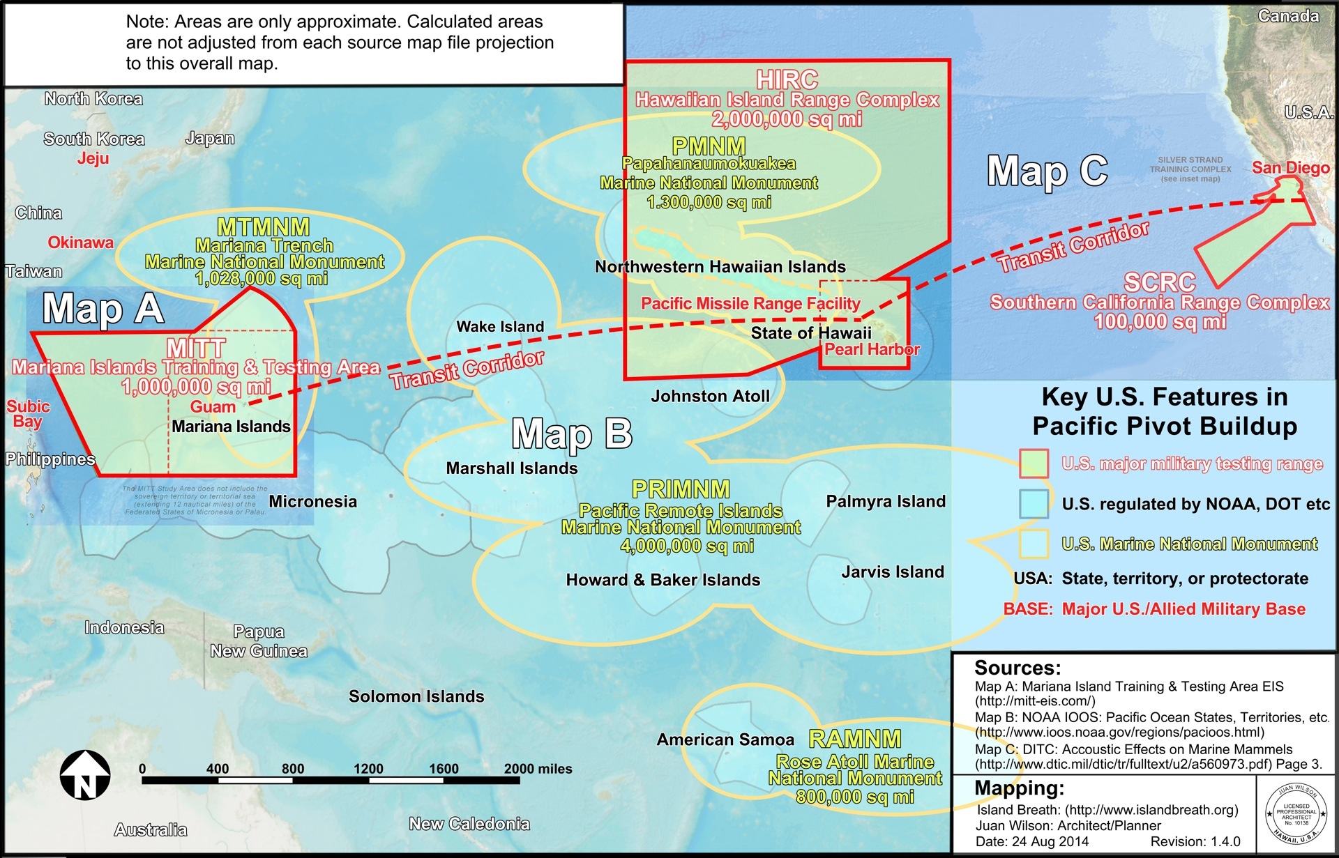
Image above: The elliptical boundary of the Pacific Remote Islands Marine National Monument shown overlapping the testing area of the Pacific Missile Range Facility on Kauai. Click to enlarge (http://www.islandbreath.org/2014Year/10/141022uspivotbig.jpg).
As an example of difficult navigation just look at the overlapping ellipses that make up the newly proposed Pacific Remote Islands Marine National Monument (or PRIMNM). It encompasses approximately four-million square miles of the Pacific Ocean and several islands used as nuclear barbeque pits in decades past. The perimeter of this area is area bounded by no less than seven overlapping ellipses.
It you were a sailor or fisherman who needed to avoid the area of the PRIMNM you would find that such curves are impossible to circumnavigate with traditional techniques. They require a constantly changing compass heading. It is much easier to navigate around a rectangular or rectilinear shape with sides made up of lines of latitude or longitude. Just bear a constant North, South, East or West.
So when the Obama Administration proposed the current marine national monument expansion of the PRIMNM the RAMNM (Rose Atoll Marine National Monument 90,000 sq miles), the MTMNM (Marianna Trench Marine National Monument 1,000,000 sq miles) and the PMNM (the Papahanaumokukea Marine National Monument 1,300.000 sq miles) you might wonder how they generated elliptical boundaries. I think I know the answer. It is a lesson in how detached and out of touch the US government is to reality on the ground (or on the sea).
I believe some hustling anonymous assistant to a committee made up of military brass, Commerce Department honchos and Obama administration aides was tasked with showing the proposed monument areas on a map of the Pacific Ocean.
That assistant was provided a jpg file by the Defense Department of our military test ranges in the Pacific. The assistant used his/her PC to open the file with CorelDRAW and preceded to use the application's ellipse drawing tool to surround the proposed monument areas under consideration with overlapping ellipses following the instruction from "Now to Make Hippos using CorelDRAW".
Image above: A step in the instructions for drawing a hippo (and Pacific Remote Islands Marine National Monument boundaries) with CorelDRAW. From (http://www.duniamedia.com/coreldraw/how-to-make-hippos-using-coreldraw.html).
As you may know, now the US Federal Government is proposing expanding the Hawaiian Islands Humpback Whale National Marine Sanctuary (HWNMS). The areas making up the sanctuary would be administered by the National Oceanic and Atmospheric Administration (or NOAA) and include the whole state.
When Kauai fishermen, indigenous Hawaiians, and sovereignty advocates got wind of the plan they put together a six-page resolution endorsed by some 6,000 Kauai ocean users who oppose to the expansion of the HWNMS. This was presented to the Kauai County Council for approval. The Council, in a typical act of political cowardice, deferred the item until October.
There were public meetings conducted by NOAA to present the expansion plan to Hawaiian residents. The meetings were packed with interested members of the public and did not go well for Sanctuary Superintendent Malia Chowin her presentation.
The meetings were rauckus and on occasion profane. Many members of the public were suspicious and angry. See TGI here (http://thegardenisland.com/news/local/first-sanctuary-meeting-draws-fire/article_b45a7a96-f388-11e4-ac4b-4786d5f0d807.html) 3/27/15.
One upshot is that the HWNMS expansion presentation scheduled for today on Oahu has been cancelled by NOAA with this statement of their website (http://hawaiihumpbackwhale.noaa.gov/)
"The Sanctuary Advisory Council Meeting that was scheduled for May 18, 2015 at the Pagoda Hotel in Honolulu has been cancelled. Stay tuned for the rescheduled meeting date."I guess it is time to reassess the public relations of this Humpback Whale Sanctuary. You can submit testimony on this issue at (http://hawaiihumpbackwhale.noaa.gov). You have until June 19th 2015 to comment. Also you can write our governor. An example from the bulletin board at Salt Pond Store is below.
To: Office of the Governor |
.
No comments :
Post a Comment