Showing posts with label NOAA. Show all posts

Hawaiian spinner dolphin restriction

SUBHEAD: NOAA considering a 150 foot buffer zone restricting swimming near dolphins.

By Aja Hannah on 4 January 2017 for Earth Island Journal -
(http://www.earthisland.org/journal/index.php/elist/eListRead/noaa_ban_swimming_spinner_dolphins_hawaii/)
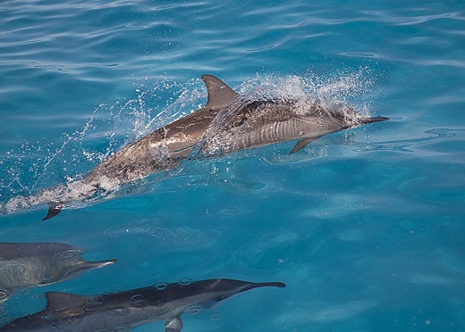

Image above: Spinner dolphins in Hawaii's Papahanaumokuakea Marine National Monument. From original article.

The proposed banned zone is intended to protect marine mammals from over-eager tourists.

[IB Publisher's note: Even 150' may be too close for approaching swimmers. Here on Kauai it is certainly it is too close for tourist filled zodiacs and catamarans that spot a pod of spinners during daylight hours and rouse them for sleep to dance for the tourists. They sail from Hanapepe along the south shore and to the westside and along the Napali Coast.]

Imagine you're sleeping and a friend comes over unannounced. You might hang out for a few hours or you might walk them out. Either way, they eventually leave and you return to bed. You're just getting into that good sleep when another person knocks on the door. Then another and another. All night this continues. Then it happens again the next night. And the night after that.

This is the current problem plaguing the Hawaiian spinner dolphin, one of the smallest dolphin species, well-known for their airborne twisting jumps.

The mainly nocturnal mammals spend their daylight hours resting near the shores of the Hawaiian Islands in shallow waters, but a growing number of tourists, tour companies, and increasing human interaction are impacting the health of the dolphin pods as well as individual dolphins.

In August, National Oceanic and Atmospheric Administration (NOAA) Fisheries proposed a rule that would ban everyone from swimming with Hawaiian spinner dolphins. Under the rule, no one would be allowed get within 50 yards of spinner dolphins by any means. This includes by boat, kayak, paddleboard, swimming, and other type of transportation.

The proposed ban has proven controversial, even among those who agree that spinner dolphins need protections. Hawaii’s economy, of course, is sustained by tourism, and local operators are concerned the ban may negatively impact their business.

At four to seven feet long, Hawaiian spinner dolphins (Stenella longirostris) spend the night hours off Hawaiian shores in search of fish, shrimp, and squid. In the darkness, these mammals track their prey to depths of nearly 1,000 feet, communicate through echolocation, and work cooperatively to herd prey for the catch.

As sunrise arrives, the dolphins return to the shallow coasts to socialize, sleep, and nurse their young until late in the afternoon. Dolphins remain in motion when they sleep: For four to five hours every afternoon, the dolphins will swim slowly back and forth, coming up for air when necessary, while half of their brain sleeps, a unique adaptation for dolphins and whales that are required to control their own breathing at all times.

When a vessel or person approaches a pod, dolphins are interrupted from their sleep — they wake up completely to assess the threat. When this happens repeatedly — as it often does — the dolphins become exhausted, and have less energy for other activities, including responding to threats, hunting, or caring for their young.

According to studies cited in the NOAA Fisheries’ proposal, short term changes in spinner dolphin behavior due to human interference have already been documented in Hawai’i, including a decreased number of individuals sighted in typical resting places. While this is not definitive of a decreased population, it at least means the dolphins have moved from traditional resting grounds.

“Several studies have suggested that spinner dolphins exhibit behaviors outside of their normal resting behaviors in response to human interactions in Hawaii. Disturbed individuals incur an energetic cost,” said Ann Garrett, the assistant regional administrator of NOAA Fisheries. Interactions that cause such behavioral changes qualify as “harassment” of marine mammals under the MMPA.

Spinner dolphin pods can be found off the coasts of Kauai/Niihau, Hawaii (The Big Island), and Oahu and do not interbreed throughout Hawaii’s archipelago. Disturbance of one individual can also disturb the whole pod into relocating and interrupts nursing mothers.

“Long-term studies on dolphins in different parts of the world have documented negative impacts from intense viewing pressure, including population decline, habitat abandonment, and decreased reproductive success,” Garrett added. “The enhanced protections were proposed in response to both identifiable short-term changes in behavior and as a preventative measure,”she said, referring to the proposed 50-yard buffer zone.

Although not listed under the Endangered Species Act, the dolphins are already protected under the MMPA, which makes it illegal to harass, feed, hunt, capture, collect or kill any marine mammal or collect or possess any part of a marine mammal. Harassment includes any pursuit, torment, or annoyance that could injure or disturb marine mammals, including activities that disturb behavioral patterns.

The MMPA is currently implemented in Hawai’i by NOAA Fisheries Office of Law Enforcement, the US Coast Guard, and Hawaii’s Division of Conservation and Resources Enforcement. Maximum penalties for violation of the law include a civil fine of $27,500 or — for criminal penalties — one year in prison and/or a $100,000 fine. Enforcement of the law, however, has been spotty, and most people visiting Hawai’i are unaware of the restrictions.

NOAA Fisheries and partners have also established a certification program, Dolphin SMART, which businesses can join to show their support for the species. Dolphin SMART promotes dolphin conservation by minimizing harassment, and includes a 50-yard distance requirement. Operators wishing to become certified must attend training and participate in responsible advertising, among other criteria.

The proposed 50-yard NOAA rule would enhance and clarify these existing protections for spinner dolphins. Exceptions to the rule would include: people who inadvertently come within 50 yards of a dolphin, as long as they make efforts to move away; vessels that are approached by dolphins, as long as the vessel remains on its course; vessels that cannot safely keep a 50-yard distance when going to or from a port or harbor; and emergency situations when imminent or serious threat must be avoided.

Other alternative rules under consideration include a 100-yard restriction and closure of important daytime habitats to swimmers at certain times of day, including four bays on the Big Island and one on Maui. These measures are unlikely to be adopted at this time, but could be adopted in the future if the 50-yard limit does not provide enough protection.

Hearings for the proposal have drawn more than 300 people from four islands and NOAA Fisheries is still compiling the written comments it received.

Dolphin Discoveries has been in business for 25 years on the Big Island, running swim tours and writing local guidelines on sustainable dolphin swims.

Co-owner of Dolphin Discoveries Kevin Merrill said, “Usually when we get in the water, we just float and the dolphins swim by. We know the dolphins are nocturnal and need to rest. Responsible operators cease at about 11:00 a.m.”

Merrill explained that legal issues and missteps created an excess of boating permits and an oversaturated tour market in Kona, a touristy area on west side of the Big Island. “Because of the way [the local government] issued permits, you have people trying to scratch out a living doing whatever they can. You’ve got all these knuckleheads that don’t understand what they’re doing with the dolphins, but they invested in a boat and have a permit.”

While conducting his tours, Merrill has encountered people driving through the pods at high speeds so that the dolphins will swim and jump at the bow. He’s seen overhand swimming and splashing tourists, which is seen as aggressive behavior by the dolphins.

Tour boats sometimes drive into the middle of pods and have clients drop into the water almost on top of the dolphins. And, of course, some operators continue to conduct swims past the ideal 11:00 a.m. limit, preventing dolphins from sleeping. Voluntary guidelines have been established locally, but there is no law to enforce the guidelines or to penalize the offenders.

Merrill believes the dolphins need protection, but there are better alternatives that would protect both dolphins and local businesses. Instead of banning the entire practice of swimming with dolphins in Hawaii, Merrill would rather see complete closures of critical habitats and time limits on swimming with dolphins made mandatory and enforced by NOAA.

These restrictions would also be easier to patrol than a 50-yard limit, he said, especially considering that the dolphins, tides, and people are constantly in motion. The new rule could put local, responsible operations out of business. “We think there should be local solutions to local problems,” he said.

Merrill also pointed out that captive facilities would be exempt from this the 50-yard ban. As a result, the only way for people to have a close encounter with a dolphin would be in a small tank. There’s the possibility that this would increase demand for captive dolphins.

However, Garrett said the 50-yard rule would level the playing field among businesses.

The pressure for close interactions with spinner dolphins would wane since no operators could legally provide them, she said, and tour operators would develop other alternatives, including wildlife tours that help customers spot the dolphins and other animals from a distance.

Mark Palmer, associate director of the International Marine Mammal Project, a project of Earth Island Institute, is a proponent of the ban. “While there is room for experimentation, in the end the needs of the dolphins are most important.

We may well need to go for swimming closures in areas necessary for dolphin respite,” he said. “I also think the issue is bigger than just the official whale watching tour companies — individual tourists are a problem.”

Because of that, he thinks that close supervision and enforcement by NOAA Fisheries will be required if the rule is passed, and that tourists will still need to be educated on why the dolphins should not be approached.

NOAA expects to make a decision on the proposed rule in late 2017.

.
Papahanaumokuakea Expansion

SUBHEAD: Hawaii and international law recognizes and protects "Subsistence Fishing" not "Sustenance Fishing".

By Mililani Trask on 6 August 2016 in Island Breath -
(http://islandbreath.blogspot.com/2016/08/papahanaumokuakea-expansion.html)


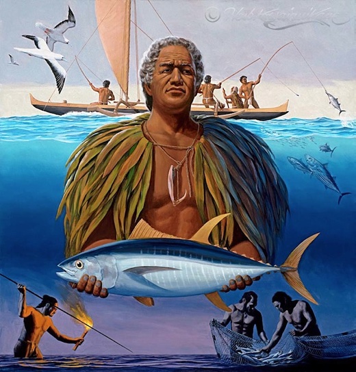
Image above: Painting of traditional Hawaiian fishing by Herb Kane. From (http://herbkanehawaii.com/).

There was no mistake made by the Environmentalists, Isaac Harp or Marjorie Ziegler when it comes to "Subsistence fishing" for Hawaiians in the Monument.

We worked on this for years BEFORE the Monument was finally created in 2006. When discussions first arose the feds did not believe what fishermen and kupuna were saying about the necessity of including the traditional Hawaiian resource users/managers.

The Feds had no background in this area and the National Oceanic and Atmospheric Administration (NOAA) and other federal agencies did not want to work with Western Pacific Regional Fisheries Council (WESPAC) and felt that the WESPAC was too local and Hawaiian oriented.

[IB Publisher's note: WESPAC is a subsidiary of NOAA, and NOAA is a subsidiary of the US Department of Commerce.]

I was at the United Nations at the time and had brought out some of the work we were doing at the UN on Traditional Knowledge and Resource Management with Indigenous Peoples.

Finally, the feds acknowledged they had no background and a hired a consultant to do an "unbiased" report on the "subsistence" issue for the Hawaii National Pacific Ocean Monument planning. They used the international criteria and worked closely with fishermen and kupuna.

The term "Subsistence" was used because this is how Hawaiians, the Hawaii State Constitution,  the rules of the Hawaiian Department of Land And Natural Resources and International law characterized the human right itself discussed always as "SUBSISTENCE FISHING".

The report was completed in March 2004. When the report came out, there was concern hat the authors had misrepresented what the Kupuna had said. The actual quotes from Kupuna did not support limiting subsistence rights to 'eating in the monument' but the report said it did.

The Kupuna had noted that unless subsistence fishing continued for Hawaiians, the traditional knowledge of fisheries and fishery management would be lost. They supported the ongoing practice of Hawaiians for gathering, worship, voyaging and fishing in the Monument in order to ensure the perpetuation of cultural management practices in the Monument

 The authors said there needed to be a new definition of 'subsistence' in the monument but promised that Hawaiians would be able to continue fishing to feed their families. This is when the idea of a Co-Op first emerged.

A few Captains had boats large enough to go up t the NWHI, and these captains were willing to support a Co-Op if someone could organize the distribution of food once the vessels returned.

OHA's staffer Heidi discussed this with me several times.  The other point that was contused in the report was the opposition to commercial fishing.

Even Uncle Buzzy felt that commercial fishing should be limited to wise management regimes, but Buzzy never support terminating commercial fishing altogether, he always supported the industry he said he was part of - but he wanted restrictions and limits to ensure there would be fish for Hawaii, Hawaiians & everyone else.

After the report came out, the NOAA formed their cultural adviser group - few fishermen & many hula dancers.

They continued to represent that our subsistence rights would be accommodated, it was bullshit.

When the final rules came out, they replaced "SUBSISTENCE" fishing with "SUSTENANCE" fishing.

[IB Publisher's note: In other words, the constitution of the state of Hawaii and international law recognizes and protects Hawaiian "SUBSISTENCE FISHING" not "SUSTENANCE FISHING".]

NOAA said that that the term "subsistence" had an established meaning legally, and they could not change the meaning legally so they decide to use the word "SUSTENANCE" instead.

This was ten years ago. I know. I was there. So was Isaac Harp and Ziegler. Check the record, its Isaac Harp (not me) who has been and still is on several of the Federal and State allegedly Hawaiian committees, as a cultural adviser.

Check the record, read the 2004 Report, stop the misrepresentations. This is a serious food security issue for our peoples and for our State. We have subsistence rights, Harp and Ziegler and the US are denying these rights.

The Environmentalists and their advisers thought it as a joke - that they had tricked the Hawaiians by changing the terminology. When the dust settled only they were laughing.

Everyone else saw it for what it was - a deliberate misrepresentation that operated to keep our Hawaiian fishermen from feeding their families and that would prevent the incorporation of Hawaiian indigenous knowledge into marine resource management.

And as you all can see..... its still at work.

Isaac Harp is now threatening to go to the big US Bully (GAO) to complain about WESPAC.

WESPAC has been attacked by PEW and the Washington environmentalists who have funded the local environmental groups for years on this issue.

Search all you want, I have never been paid by the US for my human rights work, including the Complaint to the UN against the US and World Heritage Committee (WHC) for the racism and human rights violations relating to the Marine Monument.

I am sure that the WESPAC fiscal officer will verify that Kitty Simmons (WESPAC director) is truthful as am I, the record reflects the opposite when it comes to others in this ongoing debate.

I urge everyone to inform themselves, read the reports and make an informed decision. This impacts our right to food and the preservation of traditional knowledge and cultural rights of our peoples.


.

Another USA Pacific territorial grab?

SUBHEAD: Yes, yes. We know it's to save the whales. Just like the US Navy Range is to protect us from the Chinese.

By Juan Wilson on 18 May 2015 for Island Breath -
(http://islandbreath.blogspot.com/2015/05/another-usa-pacific-territorial-grab.html)

http://www.islandbreath.org/2015Year/05/150518niihaubig.jpg
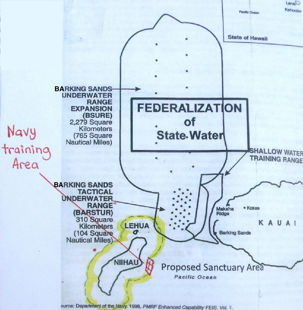
Image above: Map showing proposed Whale Sanctuary boundary around Niihau in yellow. Note it just encloses an offshore Navy training area and overlaps the Barking Sands Underwater Range Expansion area - thus blocking north south passage between Niihau and Kauai under some circumstances. Click to enlarge. From poster on a bulletin board at Salt Pond Store in Hanapepe that urged interested parties make comment on sanctuary expansion.

It has been called the Asian Pivot by talking heads, pundits and political flacks. It seemed it was going to be the final chapter in the westward expansion of America across the world. I suppose it began with the taking of Hawaii and the Spanish American War and was fulfilled World War Two in the Pacific: then perpetuated with the atmospheric nuclear tests through the fifties and began degrading with the Vietnam debacle and subsequent defeat.

 It is my opinion that American expansion of authority in the Pacific Ocean may have crested. There seems to be an increased skepticism and resistance to claims by America of open ocean and island nations despite our "historic victories" and newer assertions.

Note that as dedicated, environmentally aware and scientific some National Oceanic and Atmospheric Administration staff are, that NOAA is a subsidiary of the Commerce Department and is responsible for administering commercial fishing throughout American territories in the Pacific (including Hawaii) through through the Western Pacific Regional Fisheries Council (WESPAC).

In recent decades the military ranges, marine sanctuaries and monuments that the Navy and NOAA administer have grown and overlapped alarmingly.

This is happening to such an extent that we are creating a contiguous area that claims millions of square miles of the Pacific (that include dozens of strategic islands) - an area that would be hard for any navigator to avoid sailing into.

(http://www.islandbreath.org/2014Year/10/141022uspivotbig.jpg
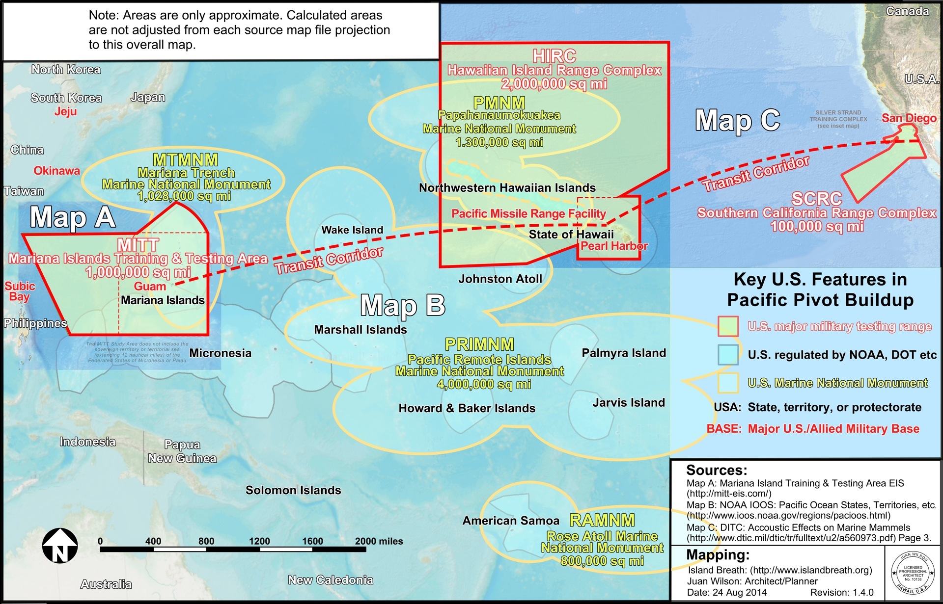
Image above: The elliptical boundary of the Pacific Remote Islands Marine National Monument shown overlapping the testing area of the Pacific Missile Range Facility on Kauai. Click to enlarge (http://www.islandbreath.org/2014Year/10/141022uspivotbig.jpg).

As an example of difficult navigation just look at the overlapping ellipses that make up the newly proposed Pacific Remote Islands Marine National Monument (or PRIMNM). It encompasses approximately four-million square miles of the Pacific Ocean and several islands used as nuclear barbeque pits in decades past. The perimeter of this area is area bounded by no less than seven overlapping ellipses.

It you were a sailor or fisherman who needed to avoid the area of the PRIMNM you would find that such curves are impossible to circumnavigate with traditional techniques. They require a constantly changing compass heading. It is much easier to navigate around a rectangular or rectilinear shape with sides made up of lines of latitude or longitude. Just bear a constant North, South, East or West.

So when the Obama Administration proposed the current marine national monument expansion of the PRIMNM the RAMNM (Rose Atoll Marine National Monument 90,000 sq miles), the MTMNM (Marianna Trench Marine National Monument 1,000,000 sq miles) and the PMNM (the Papahanaumokukea Marine National Monument 1,300.000 sq miles) you might wonder how they generated elliptical boundaries. I think I know the answer. It is a lesson in how detached and out of touch the US government is to reality on the ground (or on the sea).

I believe some hustling anonymous assistant to a committee made up of military brass, Commerce Department honchos and Obama administration aides was tasked with showing the proposed monument areas on a map of the Pacific Ocean. 

That assistant was  provided a jpg file  by the Defense Department of our military test ranges in the Pacific. The assistant used his/her PC to open the file with CorelDRAW and preceded to use the application's ellipse drawing tool to surround the proposed monument areas under consideration with overlapping ellipses following the instruction from "Now to Make Hippos using CorelDRAW".


Image above: A step in the instructions for drawing a hippo (and Pacific Remote Islands Marine National Monument boundaries) with CorelDRAW. From (http://www.duniamedia.com/coreldraw/how-to-make-hippos-using-coreldraw.html).

As you may know, now the US Federal Government is proposing expanding the Hawaiian Islands Humpback Whale National Marine Sanctuary (HWNMS). The areas making up the sanctuary would be administered by the National Oceanic and Atmospheric Administration (or NOAA) and include the whole state.

When  Kauai fishermen, indigenous Hawaiians, and sovereignty advocates got wind of the plan they put together a six-page resolution endorsed by some 6,000 Kauai ocean users who oppose to the expansion of the HWNMS. This was presented to the Kauai County Council for approval. The Council, in a typical act of political cowardice, deferred the item until October.
See TGI here (http://thegardenisland.com/news/local/whale-wars/article_3e14e102-83cb-11e2-917a-001a4bcf887a.html) 3/3/15

There were public meetings conducted by NOAA to present the expansion plan to Hawaiian residents. The meetings were packed with interested members of the public and did not go well for Sanctuary Superintendent  Malia Chowin her presentation.

The meetings were rauckus and on occasion profane. Many members of the public were suspicious and angry. See TGI here (http://thegardenisland.com/news/local/first-sanctuary-meeting-draws-fire/article_b45a7a96-f388-11e4-ac4b-4786d5f0d807.html) 3/27/15.

One upshot is that the HWNMS expansion presentation scheduled for today on Oahu has been cancelled by NOAA with this statement of their website (http://hawaiihumpbackwhale.noaa.gov/)
"The Sanctuary Advisory Council Meeting that was scheduled for May 18, 2015 at the Pagoda Hotel in Honolulu has been cancelled. Stay tuned for the rescheduled meeting date."
I guess it is time to reassess the public relations of this Humpback Whale Sanctuary. You can submit testimony on this issue at (http://hawaiihumpbackwhale.noaa.gov). You have until June 19th 2015 to comment. Also you can write our governor. An example from the bulletin board at Salt Pond Store is below.


To: Office of the Governor
The Honorable David Y. Ige
Executive Chambers of the State Capital
Honolulu, Hawaii, 96813


I am in opposition to the proposed document Hawaii Island Humpback Whale National Marine Sanctuary: Expansion, Regulatory Revision and New Management Plan for the following reasons.

• The expansion of the Sanctuary is not justified or warranted.

• There is no justification for the proposal to move from a single species humpback whale sanctuary to managing everything in the ecosystem

• Federalization of State waters is not needed.

• The Environmental Impact Statement does not identify management gaps that need to be filled to enhance the conservation and protection of Hawaii's natural resources.

• The proposed rule clearly duplicates existing State and Federal management authority and regulations. See Appendix 4 of the Humpback Whale Sanctuary Draft Environmental Impact Statement.

• NOAA has proposed to delist the Humpback Whale from the Endangered Species list.

• The existence of the Whale Sanctuary is not justified in State waters. I am opposed to all Federal Sanctuary proposals in Hawaii.

Mahalo from

Name:

Date:

Address:


.

Runoff crucial to ocean life

SUBHEAD: New land ocean connection discovered off Molokai indicating biological dependence on land resources.  

By Catherine Cluett on 7 march 2012 in the Molokai Dispatch -  
(http://themolokaidispatch.com/new-land-ocean-connections-discovered-off-molokai/)

 
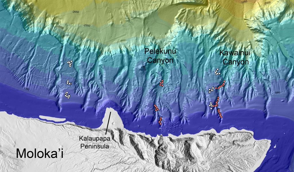
Image above: Map of ocean floor north of Molokai showing study areas. From original article. Click to enlarge.


The close connection between land and sea is nothing new for Molokai locals. But researchers have taken that connection a step farther and made a groundbreaking discovery along the coast of Molokai: they found that in two submarine canyons off the north shore of the island, ocean animals are relying heavily on resources from the land.

Fabio De Leo, a PhD candidate at University of Hawaii, Manoa Department of Oceanography, and a team of colleagues spent about three weeks a few miles out from Molokai’s north shore. They found that plant material from the forested landscapes of the shoreline, such as decomposing tree trunks, leaves and kukui nuts, feeds a high abundance of invertebrates, like worms, tiny crustaceans and mollusks. These in turn serve as food for larger species, said De Leo.

The plant material piles up in the underwater canyons that connect to the deep river valleys on the north shore.


“Areas surveyed outside the canyons showed very little…plant…material, providing support for our hypothesis that this material is really being channeled and accumulates mostly in the steep topography of the submarine canyons (i.e., a ‘canyon effect’),” said De Leo.

De Leo and his colleagues from the School of Ocean and Earth Science and Technology at UH Manoa used manned submersibles operated by the Hawaii Undersea Research Laboratory to take video in two submarine canyons off Molokai at depths ranging from 350 to 1,050 meters, or about 1,000 to 3,000 feet. This was among the first studies to quantitatively survey fish deeper than about 350 meters around Hawaii, gathering more than 13 hours of video altogether. Among the most abundant species De Leo and his team found were the so-called “rattail” fish (family Macrouridae) and the “eel-like” fish (synaphobranchids and halosaurs).

Giant sharks were also observed but only when the submersible was stationary. De Leo narrates how scary it was when he got “face–to-face” with a 10-foot “sixgill shark” with only the submersible’s porthole separating his from the shark’s nose, as the giant approached the submersible and hit the thick glass window with its face.

“Wow, it was definitely a nerve-wracking sensation,” he said. “I even dropped my video camera while trying to make good footage of the beast.”

Researchers also reported some unexpected results. They found that the “canyon effect” of fish abundances is obliterated at depths around 650 meters, coinciding exactly with the core of an oxygen minimum zone (OMZ) that flows around the Hawaiian archipelago at those depths. An OMZ is a layer of seawater that has depleted oxygen concentrations due to several biological and chemical processes. De Leo said expansion of the OMZ is concerning to scientists because it is thought to be associated with climate change and oceanic warming.

OMZ expansion is mild in Hawaii compared to the west coast of the mainland, and De Leo said it’s nothing to be concerned about in this region. But OMZ was a main topic of conversation at the Ocean Sciences Meeting in Salt Lake City, Utah, which De Leo attended last week.

De Leo’s Molokai research was done on Molokai back in 2006, and results from the data were recently released. De Leo and his colleagues will continue to analyze data from six other submarine canyons they studied around Hawaii in hopes of understanding what other factors lead to an increase in numbers and diversity of marine animals inside these topographical features.

This research was supported by NOAA Ocean Exploration and by the Hawaii Undersea Research Laboratory. University of Hawaii contributed information for this article.
.

Feds Threaten Hawaiian Sovereignty

SOURCE: Ken Taylor (taylork021@hawaii.rr.com)
SUBHEAD: The Whale Sanctuary regulation changes means Hawaiian waters resources are under Federal control.  

By Lyn McNutt on 31 January 2012 in Island Breath -
(http://islandbreath.blogspot.com/2012/02/feds-threaten-hawaiian-sovereignty.html)


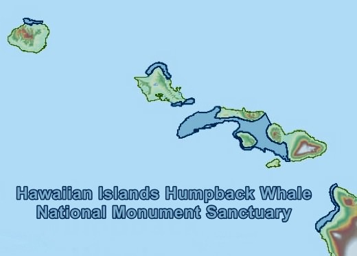
Image above: Detail of map of the waters of the Hawaiian Islands Humpback Whale National Monument Sanctuary.
From (http://sanctuaries.noaa.gov/library/imast_gis.html).

There have been changes proposed to the Humpback Whale Sanctuary that will immensely increase the power of the Federal government in Hawaiian waters, taking away the State's jurisdiction to its own waters. This takes the rights of Hawaiian residents (1.4 M) and places them at the whim of the "American people" in general, some 300-400 Million of them. This is very troubling due to the way that the National Marine Sanctuary Act and the Endangered Species Act function.

People are being lead to believe that Hawaiian peoples' rights will somehow be preserved after these changes, but my experience of how the Federal system of regulatory laws works leads me to believe that expanding any authority of the Federal government within the sanctuary can lead to very undesirable consequences (see review of compact agreement below). Currently Hawaiian Islands Humpback Whale National Monument Sanctuary (HIHWNMS) Act says:
"Sanctuary resource means any humpback whale, or the humpback whale’s habitat within the Sanctuary."
Keep in mind that whales do NOT come here to feed, so they do not compete with native Hawaiian species for resources. This is the proposed change:
"Sanctuary resource means any living or non-living resource of the National Marine Sanctuary that contributes to the conservation, recreational, ecological, historical, research, educational, or aesthetic value of the Sanctuary, including, but not limited to, the substratum of the area of the Sanctuary, other submerged features and the surrounding seabed, carbonate rock, corals and other bottom formations, coralline algae and other marine plants and algae, marine invertebrates, brine-seep biota, phytoplankton, zooplankton, fish, seabirds, sea turtles and other marine reptiles, marine mammals and historical resources."
Please NOTE that there is NO MENTION of subsistence use. In other words. everything will belong to the Feds.
The key wording in the HIHWNMS Act is this:
'The purpose of the regulations in this subpart is to implement the designation of the Hawaiian Islands Humpback Whale National Marine Sanctuary by regulating activities affecting the resources of the Sanctuary"
Therefore under the current definition of "Sanctuary resources", the sanctuary's mandate is limited to "humpback whales or the humpback whale's habitat". Under the ecosystem based management method "resources" means...

EVERYTHING INCLUDING ROCKS, WHAT IS UNDER ROCKS, AND EVERY LIVING THING IN THE WATER AND SEABIRDS ABOVE THE WATER'S SURFACE

...becomes subject to protection and regulation. Please, consider the longterm consequences of this change for the people of Hawaii. With the Federal laws as currently enforced, and the agreements in place, there really is no protection (see below) 

Notes on the Compact Agreement with the State of Hawaii and NOAA 

Please note in the agreement that NOAA, through the Sanctuary Act "has been vested with the jurisdiction and authority to protect and manage the resources of this sanctuary in trust for the People of the United States and is specifically charged with implementation of the policy of the United States". (bold lettering is mine). There is your catch because the policies of the United States may not be consistent with the laws or regulations or needs of the state of Hawaii. This allows NOAA to bring in a whole slew of federal rules and policies INCLUDING the new National Ocean Policy (remember, we have no exemptions or Strategic Plan under that policy---what goes for the Mainland goes for us, too). Section IV (D) States clearly that NOAA and the State will collaborate, but the management of the Sanctuary falls under the laws in the National Marine Sanctuary Act. In Section IV (D) (2) it says that...
"To the extent permitted by law, there shall be mutual agreement regarding enforcement policies and priorities."
The main title of that section indicates that the "law" is the "National Marine Sanctuary Act, the Sanctuary Management Plan, and MOAs, and protocols developed thereunder". ALL of these will trump the State, so beware. The agreement keeps saying that nothing will happen without the signature of the Governor, but when it comes to the Governor proposing changes (section IV (H) it says "...NOAA shall initiate the Federal rule promulgation process required to make revisions requested by the Governor..." Here is where the Endangered Species Act and other federal laws will come in. NOAA consistently "outvoted" the state in the Northwest Hawaiian Islands, and overrode the State's veto of several items related to several different species, the monk seal in particular (V. Alter, Stanford Law School, April 2006, available on request).

 It also does NOT say that fishing will not be regulated (it never mentions subsistence fishing, by the way). It says fishing is currently not included, unless DLNR implements new regulations. So, all they have to do is ask the State... and the State has a dismal record here.

  Also, the National Marine Sanctuary Act says that the Feds have the authority to "take over" if they feel that the State is not enacting laws and regulations that are effective enough. The Endangered Species Act permits the Federal Government to regulate the State's treatment of endangered species.  

So it goes back to the Federal Law trumping State law if there is a conflict in the goals of the Management Plan, and then National Marine Fisheries Service (NMFS) is the agency that will decide what needs to be done, all within the authority of the Sanctuary Act and the Endangered Species Act, under the new National Ocean Policy.

Section IV M gives NMFS oversight of all the resources for the Federal Government in the Sanctuary through "implementation of the management plan" and gives them the authority to "evaluate the effectivenedss of existing management efforts in achieving those abjectives and policies including whether additional measures (e.g. regulations or critical habitat) to protect the humpback whale or its habitat are needed)"

 OK, now substitute the word "monk seal" or "coral" for humpback whale in that sentence, and you will see that NMFS will have the authority to enact anything that they feel necessary under the ESA through the management plan and into the Sanctuary as part of the National Marine Sanctuary Act and this agreement. It also says that NOAA will "fully involve and consult with the State". It does not say that they are obligated to listen to the State. Section IV (A) says that the State doesn't relinquish its right to "title or authority to manage and regulate submerged lands, resources, or activities..." but the next two sections go on to say that the Governor agrees to put state owned lands into the Sanctuary system, and that the Sanctuary Management Plan (and therefore the laws of the Sanctuary Act) will apply throughout the ... "Sanctuary, including the portion of the Sanctuary within the seaward boundary of the State."

MOAs and Compact Agreements with references to external documents are really tricky. I used to run into the same thing with all the Space Station agreements, etc. This Agreement looks OK on the surface, since whales don't compete for resources here. Whales DO NOT EAT while they are here. Keeping this agreement in place and giving the Sanctuary the authority to add additional species that might compete for resources, such as the monk seal, would be a real mistake. They will have to create a new agreement. Stand firm on this.
.

BP Oil Disaster Could Hit Europe

SUBHEAD: BP oil disaster could hit Europe via the powerful Gulf Stream current.

By F. William Engdahl on 10 June 2010 in Market Oracle -
(http://www.marketoracle.co.uk/Article20207.html

 
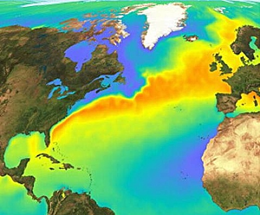
Image above: Path of the Gulf Stream to Europe shown in orange. From article.  

[IB Editor's Note: This article is the subject of a high level NOAA meeting this week.]

The Obama Administration and senior BP officials are frantically working not to stop the world’s worst oil disaster, but to hide the true extent of the actual ecological catastrophe. Senior researchers tell us that the BP drilling hit one of the oil migration channels and that the leakage could continue for years unless decisive steps are undertaken, something that seems far from the present strategy.

In a recent discussion, Vladimir Kutcherov, Professor at the Royal Institute of Technology in Sweden and the Russian State University of Oil and Gas, predicted that the present oil spill flooding the Gulf Coast shores of the United States “could go on for years and years … many years.”

According to Kutcherov, a leading specialist in the theory of abiogenic deep origin of petroleum, “What BP drilled into was what we call a ‘migration channel,’ a deep fault on which hydrocarbons generated in the depth of our planet migrate to the crust and are accumulated in rocks, something like Ghawar in Saudi Arabia.” Ghawar, the world’s most prolific oilfield has been producing millions of barrels daily for almost 70 years with no end in sight. According to the abiotic science, Ghawar like all elephant and giant oil and gas deposits all over the world, is located on a migration channel similar to that in the oil-rich Gulf of Mexico.

As I wrote at the time of the January 2010 Haiti earthquake disaster, Haiti had been identified as having potentially huge hydrocarbon reserves, as has neighboring Cuba. Kutcherov estimates that the entire Gulf of Mexico is one of the planet’s most abundant accessible locations to extract oil and gas, at least before the Deepwater Horizon event this April.

“In my view the heads of BP reacted with panic at the scale of the oil spewing out of the well,” Kutcherov adds. “What is inexplicable at this point is why they are trying one thing, failing, then trying a second, failing, then a third. Given the scale of the disaster they should try every conceivable option, even if it is ten, all at once in hope one works. Otherwise, this oil source could spew oil for years given the volumes coming to the surface already.”

He stresses, “It is difficult to estimate how big this leakage is. There is no objective information available.” But taking into consideration information about the last BP ‘giant’ discovery in the Gulf of Mexico, the Tiber field, some six miles deep, Kutcherov agrees with Ira Leifer a researcher in the Marine Science Institute at the University of California, Santa Barbara who says the oil may be gushing out at a rate of more than 100,000 barrels a day.

What the enormoity of the oil spill does is to also further discredit clearly the oil companies’ myth of “peak oil” which claims that the world is at or near the “peak” of economical oil extraction. That myth, which has been propagated in recent years by circles close to former oilman and Bush Vice President, Dick Cheney, has been effectively used by the giant oil majors to justify far higher oil prices than would be politically possible otherwise, by claiming a non-existent petroleum scarcity crisis.

Obama & BP Try to Hide

According to a report from Washington investigative journalist Wayne Madsen, “the Obama White House and British Petroleum are covering up the magnitude of the volcanic-level oil disaster in the Gulf of Mexico and working together to limit BP’s liability for damage caused by what can be called a ‘mega-disaster.’” Madsen cites sources within the US Army Corps of Engineers, FEMA, and Florida Department of Environmental Protection for his assertion.

Obama and his senior White House staff, as well as Interior Secretary Salazar, are working with BP’s chief executive officer Tony Hayward on legislation that would raise the cap on liability for damage claims from those affected by the oil disaster from $75 million to $10 billion. According to informed estimates cited by Madsen, however, the disaster has a real potential cost of at least $1,000 billion ($1 trillion). That estimate would support the pessimistic assessment of Kutcherov that the spill, if not rapidly controlled, “will destroy the entire coastline of the United States.”

According to the Washington report of Madsen, BP statements that one of the leaks has been contained, are “pure public relations disinformation designed to avoid panic and demands for greater action by the Obama administration., according to FEMA and Corps of Engineers sources.”

The White House has been resisting releasing any “damaging information” about the oil disaster. Coast Guard and Corps of Engineers experts estimate that if the ocean oil geyser is not stopped within 90 days, there will be irreversible damage to the marine eco-systems of the Gulf of Mexico, north Atlantic Ocean, and beyond. At best, some Corps of Engineers experts say it could take two years to cement the chasm on the floor of the Gulf of Mexico.

Only after the magnitude of the disaster became evident did Obama order Homeland Security Secretary Napolitano to declare the oil disaster a “national security issue.” Although the Coast Guard and FEMA are part of her department, Napolitano’s actual reasoning for invoking national security, according to Madsen, was merely to block media coverage of the immensity of the disaster that is unfolding for the Gulf of Mexico and Atlantic Ocean and their coastlines.

The Obama administration also conspired with BP to hide the extent of the oil leak, according to the cited federal and state sources. After the oil rig exploded and sank, the government stated that 42,000 gallons per day were gushing from the seabed chasm. Five days later, the federal government upped the leakage to 210,000 gallons a day. However, submersibles monitoring the escaping oil from the Gulf seabed are viewing television pictures of what they describe as a “volcanic-like” eruption of oil.

When the Army Corps of Engineers first attempted to obtain NASA imagery of the Gulf oil slick, which is larger than is being reported by the media, it was reportedly denied the access. By chance, National Geographic managed to obtain satellite imagery shots of the extent of the disaster and posted them on their web site. Other satellite imagery reportedly being withheld by the Obama administration, shows that what lies under the gaping chasm spewing oil at an ever-alarming rate is a cavern estimated to be the size of Mount Everest. This information has been given an almost national security-level classification to keep it from the public, according to Madsen’s sources.

The Corps of Engineers and FEMA are reported to be highly critical of the lack of support for quick action after the oil disaster by the Obama White House and the US Coast Guard. Only now has the Coast Guard understood the magnitude of the disaster, dispatching nearly 70 vessels to the affected area. Under the loose regulatory measures implemented by the Bush-Cheney Administration, the US Interior Department’s Minerals Management Service became a simple “rubber stamp,” approving whatever the oil companies wanted in terms of safety precautions that could have averted such a disaster. Madsen describes a state of “criminal collusion” between Cheney’s former firm, Halliburton, and the Interior Department’s MMS, and that the potential for similar disasters exists with the other 30,000 off-shore rigs that use the same shut-off valves.

Silence from Eco groups?... Follow the money


Without doubt at this point we are in the midst of what could be the greatest ecological catastrophe in history. The oil platform explosion took place almost within the current loop where the Gulf Stream originates. This has huge ecological and climatological consequences.

A cursory look at a map of the Gulf Stream shows that the oil is not just going to cover the beaches in the Gulf, it will spread to the Atlantic coasts up through North Carolina then on to the North Sea and Iceland. And beyond the damage to the beaches, sea life and water supplies, the Gulf stream has a very distinct chemistry, composition (marine organisms), density, temperature. What happens if the oil and the dispersants and all the toxic compounds they create actually change the nature of the Gulf Stream?

No one can rule out potential changes including changes in the path of the Gulf Stream, and even small changes could have huge impacts. Europe, including England, is not an icy wasteland due to the warming from the Gulf Stream.

Yet there is a deafening silence from the very environmental organizations which ought to be at the barricades demanding that BP, the US Government and others act decisively.

That deafening silence of leading green or ecology organizations such as Greenpeace, Nature Conservancy, Sierra Club and others may well be tied to a money trail that leads right back to the oil industry, notably to BP. Leading environmental organizations have gotten significant financial payoffs in recent years from BP in order that the oil company could remake itself with an “environment-friendly face,” as in “beyond petroleum” the company’s new branding.

The Nature Conservancy, described as “the world’s most powerful environmental group,” has awarded BP a seat on its International Leadership Council after the oil company gave the organization more than $10 million in recent years.

Until recently, the Conservancy and other environmental groups worked with BP in a coalition that lobbied Congress on climate-change issues. An employee of BP Exploration serves as an unpaid Conservancy trustee in Alaska. In addition, according to a recent report published by the Washington Post, Conservation International, another environmental group, has accepted $2 million in donations from BP and worked with the company on a number of projects, including one examining oil-extraction methods. From 2000 to 2006, John Browne, then BP's chief executive, sat on the CI board.

Further, The Environmental Defense Fund, another influential ecologist organization, joined with BP, Shell and other major corporations to form a Partnership for Climate Action, to promote ‘market-based mechanisms’ (sic) to reduce greenhouse gas emissions.

Environmental non-profit groups that have accepted donations from or joined in projects with BP include Nature Conservancy, Conservation International, Environmental Defense Fund, Sierra Club and Audubon. That could explain why the political outcry to date for decisive action in the Gulf has been so muted.

Of course those organizations are not going to be the ones to solve this catastrophe. The central point at this point is who is prepared to put the urgently demanded federal and international scientific resources into solving this crisis. Further actions of the likes of that from the Obama White House to date or from BP can only lead to the conclusion that some very powerful people want this debacle to continue. The next weeks will be critical to that assessment.

• F. William Engdahl, author of Gods of Money: Wall Street and the Death of the American Century and Full Spectrum Dominance: Totalitarian Democracy in the New World Order (Third Millennium Press), may be reached via his website, www.engdahl.oilgeopolitics.net.
.

NOAA & BP Worst Case Scenario

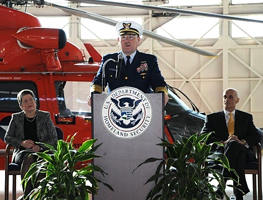
SUBHEAD: When Brice-O'Hara praised "the professionalism of our partner, BP," Napolitano quickly barked, "They are not our partner! Image above: Homeland Security Secretary Janet Napolitano listens as USGS Thad Allen speaks at podium.

[Editor's Note: The following is an excerpt from a long and excellent article on the BP disaster in the Gulf titled "The Spill, The Scandel and the President". This section of the piece deals with the original NOAA worst case estimate of the spill versus the BP public relations number. Again, USCG SuperFerry Unified Command Sally Brice-O'Hare plays bit part in propping up the Empire]

By Tim Dickenson on 8 June 2010 in Rolling Stone - (http://www.rollingstone.com/politics/news/17390/111965?RS_show_page=0)

Within hours, the government assembled a response team at the "war room" of the National Oceanographic and Atmospheric Administration in Seattle. The scene, captured by a NOAA cameraman and briefly posted on the agency's website, provides remarkable insight into the government's engagement during the earliest hours of the catastrophe, and, more troubling, the role of top administration figures in downplaying its horrific scope.

At a conference table, nearly a dozen scientists gather around a map of the Gulf. Joshua Slater, a commissioned NOAA officer dressed in his uniform, runs the show. "So far we've created a trajectory [of the slick] that was passed up the chain of command to the Coast Guard and eventually to the president showing where the oil might go," he tells the assembled team. BP's remote operated sub, he adds, "was unsuccessful in activating the blowout preventers, so we're gearing up right now."

An NOAA expert on oil disasters jumps in: "I think we need to be prepared for it to be the spill of the decade."

Written on a whiteboard at the front of the room is the government's initial, worst-case estimate of the size of the spill. While the figure is dramatically higher than any official estimate issued by BP or the government, it is in line with the high-end calculations by scientists who have monitored the spill.

"Estm: 64k - 110k bbls/Day."

The equivalent of up to three Exxon Valdez spills gushing into the Gulf of Mexico every week. Damningly, the whiteboard also documents the disconnect between what the government suspected to be the magnitude of the disaster and the far lower estimates it was feeding to the public. Written below the federal estimate are the words, "300,000 gal/day reported on CNN." Appearing on the network that same day on a video feed from the Gulf, Coast Guard Rear Adm. Mary Landry insisted that the government had no figure. "We do not have an estimate of the amount of crude emanating from the wellhead," she said.

Later in the video, a voice on speakerphone with a heavy Southern accent reveals that government scientists were concerned from the very beginning about underwater plumes of oil – a reality that NOAA administrator Jane Lubchenco and BP executives are still seeking to downplay. "They weren't sure how that oil was going to react once it was spilled," the voice says. "Whether it was going to rise, or form layers and start twisting around." The government, in short, knew from the start that surface measurements of the oil slick – on which it would premise its absurdly low estimate of 5,000 barrels a day – were likely to be unreliable.

By that evening, the White House was gearing up for an urgent response. The president convened an emergency meeting in the Oval Office with Adm. Thad Allen, Homeland Security Secretary Janet Napolitano, Interior Secretary Ken Salazar and top White House deputies Rahm Emanuel, Carol Browner and Larry Summers. Obama forcefully instructed his team that the response to the oil spill should be treated as a "number-one priority."

But then the fog of war set in. The following day, the Coast Guard – relying on assurances from BP – declared that the spill appeared to be limited to oil that was stored aboard the sunken rig. With a worst-case crisis seemingly averted, Obama checked out, heading off for a long weekend in Asheville, North Carolina, where he and the first lady would stop for ribs at a barbecue joint called 12 Bones Smokehouse before checking into the Grove Park Inn, a golf resort and spa. Asked whether the spill would hamper the president's offshore drilling agenda, spokesman Gibbs made light of the disaster. "I don't honestly think it opens up a whole new series of questions," he said. "I doubt this is the first accident that has happened, and I doubt it will be the last."

The next day, April 24th, Landry told reporters that leaks had been discovered in the riser pipe and estimated the flow at 1,000 barrels a day. "This is a very serious spill," she said. Over the next five days, the administration took significant steps to deal with the spill, but the effort fell far short of what was needed to tackle a crisis that BP was already privately estimating could be as catastrophic as 14,000 barrels a day. A Joint Information Center – a strange partnership involving BP, the Coast Guard and MMS – was set up in Louisiana. Senior officials met with BP CEO Tony Hayward to "receive briefings on the company efforts to stop the flow." The Navy opened a base in Florida as a staging area for BP's cleanup work. Salazar ordered inspections for rigs throughout the Gulf and visited BP's command center in Houston. Napolitano began an investigation into the disaster.

The president himself was occupied elsewhere. After returning from his vacation, Obama spent Monday, April 26th palling around with Derek Jeter and the New York Yankees, congratulating them on their World Series victory. He later took time to chat with the president of Honduras. When he put in a call to Gov. Haley Barbour of Mississippi, it was to talk about tornadoes that had caused damage in that state, with only a brief mention of the oil spill. On Tuesday the 27th, Obama visited a wind-turbine plant in Iowa. Wednesday the 28th, he toured a biofuels refinery in Missouri and talked up financial reform in Quincy, Illinois. He didn't mention the oil spill or the Gulf.

That evening, administration officials received news that – to judge from their subsequent response – scared the shit out of them. "The following is not public," a confidential NOAA advisory stressed. "Two additional release points were found today in the tangled riser. If the riser pipe deteriorates further, the flow could become unchecked, resulting in a release volume an order of magnitude higher than previously thought. There is no official change in the volume released but the [Coast Guard] is no longer stating that the release rate is 1,000 barrels a day. Instead they are saying that they are preparing for a worst-case release and bringing all assets to bear."

Standing before the cameras, a visibly shaken Landry bumbled through the reading of a press release. Although BP continued to believe its estimate of 1,000 barrels a day, she said, "NOAA experts believe the output could be as much as 5,000 barrels." The remarks established, for the first time, a figure that both BP and the government would stick to long past its sell-by date.

After he was briefed that evening, Obama told his deputies to contact the Pentagon. The following day, Napolitano declared the BP disaster, which was now approaching the size of Puerto Rico, an "Oil Spill of National Significance" – the designation required to draw on regional resources and to appoint an incident commander to coordinate a federal response. It had taken a full week after Deepwater Horizon exploded for the government to become fully engaged – a critical lapse that allowed the crisis to spiral out of control.

The White House press office organized a show of overwhelming force, with Gibbs convening Browner, Napolitano, Deputy Interior Secretary David Hayes, EPA chief Lisa Jackson and Coast Guard Rear Adm. Sally Brice-O'Hara for a single press conference on April 29th. Though clearly meant to signal engagement, the all-star crew didn't have their message straight. When Brice-O'Hara praised "the professionalism of our partner, BP," Napolitano quickly barked, "They are not our partner! They are not our partner!" For her part, Napolitano revealed that she didn't know whether the Defense Department possessed any assets that could help contain the spill, and referred vaguely to "whatever methodologies" BP was using to seal the well.

Instead of seizing the reins, the Obama administration cast itself in a supporting role, insisting that BP was responsible for cleaning up the mess. "When you say the company is responsible and the government has oversight," a reporter asked Gibbs on May 3rd, "does that mean that the government is ultimately in charge of the cleanup?" Gibbs was blunt: "No," he insisted, "the responsible party is BP." In fact, the National Oil and Hazardous Substances Pollution Contingency Plan – the federal regulations that lay out the command-and-control responsibilities for cleaning up an oil spill – makes clear that an oil company like BP cannot be left in charge of such a serious disaster. The plan plainly states that the government must "direct all federal, state or private actions" to clean up a spill "where a discharge or threat of discharge poses a substantial threat to the public health or welfare of the United States."

"The government is in a situation where it's required to be in charge," says William Funk, a professor of environmental and administrative law at Lewis and Clark College who previously worked as a staff attorney in the Justice Department.

What's more, the administration failed to ensure that BP was prepared to respond to the mess on the surface, where a lack of ships and equipment has left more than 100 miles of the coast – including vast stretches of fragile marshlands – covered in crude. According to MMS regulations, the agency is supposed to "inspect the stockpiles of industry's equipment for the containment and cleanup of oil spills." In BP's case, the agency should have made sure the company was prepared to clean up a spill of 250,000 barrels a day. But when Rolling Stone asked MMS whether BP had the required containment equipment on hand, the agency's head of public affairs in the Gulf replied, "I am not clear if MMS has the info that you are requesting."

The effect of leaving BP in charge of capping the well, says a scientist involved in the government side of the effort, has been "like a drunk driver getting into a car wreck and then helping the police with the accident investigation." Indeed, the administration has seemed oddly untroubled about leaving the Gulf's fate in the hands of a repeat criminal offender, and uncurious about the crimes that may have been committed leading up to the initial sinking of the rig. The Obama Justice Department took more than 40 days after the initial blast killed 11 workers to announce it was opening a criminal probe.

From the start, the administration has seemed intent on allowing BP to operate in near-total secrecy. Much of what the public knows about the crisis it owes to Rep. Ed Markey, who chairs the House Subcommittee on Energy and the Environment. Under pressure from Markey, BP was forced to release footage of the gusher, admit that its early estimates put the leak as high as 14,000 barrels a day and post a live feed of its undersea operations on the Internet – video that administration officials had possessed from the earliest days of the disaster. "We cannot trust BP," Markey said. "It's clear they have been hiding the actual consequences of this spill."

See also: Ea O Ka Aina: NOAA Insider Vents on Oil Spill 6/4/10 Ea O Ka Aina: EPA Going after BP? 5/22/10 Ea O Ka Aina: Gulf Spill 70,000 Barrels a Day 5/13/10

.