Showing posts with label Niihau. Show all posts

Less rats mean more birds and fish

SUBHEAD: Rodent eradication saves chicks and fertilizes soil and reefs for better biodiversity.

By Jan TenBruggencate on 6 July 2018 for Raising Islands -
(http://raisingislands.blogspot.com/2018/07/new-study-finds-rat-eradication.html)


Image above: Rat in tree eating Hawaiian bird eggs. From (https://conservationbytes.com/2015/01/06/help-hawaiis-hyper-threatened-birds/).

If the rat eradication of Lehua Island (in Kauai County, Hawaii) ends up being successful, it could result in a more productive nearshore fishery.

Which is ironic, in that many of those fighting the eradication program were fishermen.

A new study in the journal Nature says that when rats kill off seabirds on islands, it means those birds are no longer pooping in the nearshore waters, fertilizing reefs. And that means fewer fish on those reefs.

This study was done in the Chagos Archipelago, where some islands have rats and others are rat-free. Researchers looked at both the fertility of the land on those islands and the productivity of their reefs, where erosion from the land would carry nutrients like bird-poop-sourced nitrogen.

The Chagos are atolls and reefs just south of the Equator in the Indian Ocean. Their ownership is disputed between Great Britain and Mauritius. One is Diego Garcia, which houses a U.S military base.

The results of the research were clear, said the authors, who are from Australian, British, Danish and Canadian research institutions.

On islands without rats, seabird density as well as nitrogen deposits were hundreds of times higher. Yes, hundreds: 250 to more than 700 times higher.

Those rat-free islands had reefs that had 48 percent more biomass of "macroalgae, filter-feeding sponges, turf algae and fish."

The researchers looked specifically at damselfish, and found that they both grew faster and had higher total biomass on the rat-free islands.

The theory, then, is that seabirds feed in the open ocean, deliver bird poop to the islands, and that the islands then feed the nearshore waters, which makes the waters more productive and capable of producing more fish.

"Rat eradication on oceanic islands should be a high conservation priority as it is likely to benefit terrestrial ecosystems and enhance coral reef productivity and functioning by restoring seabird-derived nutrient subsidies from large areas of ocean," the authors wrote.

Rats are not the only problems on islands. On Midway Atoll, near the western end of the Hawaiian archipelago, mice began eating seabirds after rats were removed from the islands there. The case of the vampire mice, which chewed into the necks of Laysan albatross, is reviewed here.

On other islands, the mice even seemed to be getting bigger on their diets of eggs and bird flesh. The Washington Post was among the many international publications that picked up the vampire mouse story.

All that said, rodents mainly go after eggs and chicks of nesting seabirds. That was the case at Lehua Island. Here is a description of the situation on the little island north of Ni`ihau before an application of a rodenticide to try to wipe out the rats.

"We found Wedge-tailed Shearwater and Red-tailed Tropicbird eggs broken open, the edges gnawed, the insides consumed. Tiny seabird chick bodies were commonplace–pulled out of burrows and half eaten.

This was particularly true for the diminutive Bulwer’s Petrel–the vast majority of Bulwer’s Petrel burrows we found had bits and pieces of chick inside," wrote Andre Raine, Project Manager for the Kauai Endangered Seabird Recovery Project.

A couple of months after the 2017 rat eradication effort at Lehua, Raine said he could clearly see the difference:

"Fat, healthy Wedge-tailed Shearwater chicks shuffled about in their burrows looking like animated fuzzballs. One of our burrow cameras showed a Bulwer’s Petrel chick exercising outside its burrow and actually fledging – a great omen, as this is something we have never recorded on our cameras in previous years," he wrote.

Most, but not all the rats were killed off at Lehua, and wildlife crews were back this year with rat-hunting dogs to try to kill off the survivors and protect the island's nesting seabird population.

And the island's coastal reefs and fisheries.
The removal of rats from islands is a major conservation effort. It has been done successfully at islands in Hawai`i like Mokoli`i off O`ahu and Mokapu off Molokai.

When it was accomplished at Palmyra Atoll south of the Hawaiian Islands, it had the unintended effect of killing off the disease-causing Asian tiger mosquito, which had depended on rats for blood meals. 
.

Impact of Lehua rat poisoning

SUBHEAD: Will the aerial rat poison drop endanger Niihauans and the local fisheries?

By Kawai Warren on 7 June 2017 for Island Breath -
(http://islandbreath.blogspot.com/2017/06/impact-of-lehua-rat-poisoning.html)


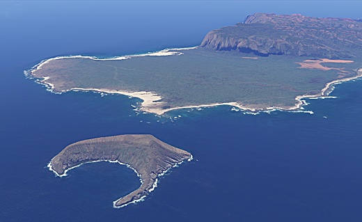
Image above: North-west coast of Lehua Island in foreground with Niihau Island in background. Photo by Juan Wilson on 7/9/11.

I attended the community meeting for the Environmental Assessment Draft in Kekaha. Their was a handful of fisherman that expressed their concern about the side effects of the rat extermination poison and aerial application.

A day after the meeting, we got word that our comments at the meeting were to "do it quickly".

At the meeting I attended in Kekaha no one supported the aerial drop, because the impact it could have on the fisherman, Niihauians, fish, limu, coral, opihi, a' am a, and ocean ecosystems.

The US Fish and Wildlife Service and the Hawaii Department of Land and Natural Resources (DLNR)  are trying to get this done this summer. Unless the fisherman raise their voices and get the media involved. Check out the article below.

Our fisheries (near shore) on the Westside is all ready impacted by these chemicals Atrazine, bentazon, chlorpyrifos, fipronil, metolachlor, propiconazole, and simozine from Kinikini ditch and second ditch during seasonal flooding.


Image above: GoogleEarth 2011 aerial perspective showing proximity of Lehua and Niihau Islands. Same orientation direction as photo above. Only about 4,000 feet separate the two. Image by Juan Wilson.


The Lehua Aerial Poison Drop

SUBHEAD: A risk that the lethal anticoagulant rodenticides could impact the biologically diverse area.


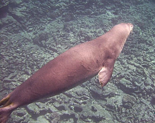
Image above: Photo of monk seal swimming close to shoreline of Lehua Island in shallow water. Photo by Richard Jarke on 7/9/11.

By Maggie Sergio on 7 June 2017 for Huffington Post - 
(http://www.huffingtonpost.com/entry/5936e141e4b033940169ce56)

In Hawaii, the Department of Land and Natural Resources (DLNR), and U.S Fish and Wildlife Service (USFWS) are planning several rat poison drops via helicopter onto Lehua Island, located approximately 30 miles west of Kauai.

These drops are being fast-tracked for this summer, part of an eradication project for the 284 acre bird sanctuary.

The planned drop is three-quarter of a mile from an important Native Hawaiian community on Niihau. There is risk that the poison pellets (lethal anticoagulant rodenticides) could impact the biologically diverse and important Lehua Crater.

Sources indicate that DLNR and USFWS are pressuring the State Department of Agriculture to grant permission for the poison bait to be dropped right up to the shoreline, which will result in bait entering the marine environment, allowing the toxins to infiltrate and settle in waters frequented by commercial and Native Hawaiian subsistence fishermen.

The agencies will not disclose or estimate the duration or extent of any fishing bans for tour and recreational boats in surrounding waters. The extent of a ban might be of concern to the local fishing and tour boat communities, given that a 942-day fishing ban was recommended after another Island Conservation poison drop on Wake Island in the in 2012.

If given the green light, the poison drops will happen on Lehua this summer, delivering an estimated 8-10 tons of anticoagulant rodenticide. Birds, fish, monk seals, and other wildlife that consume the cereal-based poison bait either directly or indirectly (secondarily) will be affected, and there is risk of contaminating the food web.

Note: the estimated application rate has been calculated from the amount disclosed on a kg/per hectare basis. Pesticide labels were not included in the draft environmental assessments (EA), so it is unclear if the proposed amount to be dropped is within legal limits.

The Failed 2009 Poison Drop Lehua Controversy
This will be the second poisoning of Lehua in the name of “conservation,” after a failed attempt in 2009. The previous drop was highly controversial—dead fish washed up on the neighboring island of Niihau, and a juvenile whale beached itself.

The state of Hawaii claimed the fish die-off and dead whale were “coincidental” and not related in any way to the nearly four tons of rat poison that had been dropped on the island just days earlier.

After researching the failed event in 2009, which included findings in this presentation given at a national pesticides conference, questions remain about what really happened.

Why was there a two month delay in requesting the fish be tested for exposure to the poison?

Since the rodenticide used in 2009, diphacinone, metabolizes quickly, did the delay in testing capture meaningful results? Are the chain of custody documents available for review?

Could ultra-nutrification and de-oxygenating of the waters, due to the cereal component of the poison bait that entered the surrounding ocean, be a contributing reason for the algae bloom, which, officials claimed, was the cause of the fish kill?

Or, could the poison pellets that entered the marine environment have impacted the fish, not enough to kill them, but enough to cause immunosuppression, thereby making the fish more susceptible to the impacts of an algae bloom? These questions have never been addressed by the agencies.

Are Rats a Problem on Lehua? - Not According to the Data
The data provided in both draft EAs (both the state and feds created a draft environmental assessment) does not support that the rodents on Lehua are having a negative impact on the bird life on the island.

All evidence provided is anecdotal, and astonishingly, USFWS has no idea of the size of the rodent population. One could reasonably ask—since this critical piece of data is unknown—why is this project being fast tracked?

The agencies need to respond to these questions: Why is the collateral damage and potential risk to the food web, in addition to putting sustenance and commercial fishermen in jeopardy, worth the risk? How much consideration was truly given to the Native Hawaiian Ni’ihauans in this accelerated operation, aside from conversations set up and/or attended by the owner of Ni’ihau, the Robinson family?

The only evidence of rodent impact to birds included in the state issued EA shows that four eggs from the nest of a wedge tail shearwater showed indication of predation by rats.

As the wedge tailed shearwater is considered to be a species of least concern by the IUCN (with a worldwide population of over 5 million birds), this hardly constitutes a scientifically-based rationale for dropping 8-10 tons of pesticide, threatening the fragile ecosystem, rare reef system, and food chain.

The DLNR and USFWS have yet to respond to public demands for site-based scientific (vs. anecdotal) evidence on the Lehua rat population, bird decline and mortality causation on Lehua, if any, that justifies this large scale poison drop.

Downplaying Risks  - The Selling of Island Eradication Projects
Both EAs issued mispresent environmental risks, and make misleading statements about the lethal and sub-lethal impacts to wildlife poisoned, which are referred to as “non-target species.”

Though the proposed poisons have never been tested on coral reefs, and the impact is completely unknown, the EA makes the puzzling, badly worded statement on page 73 of the federal EA that “there are no data to indicate corals have been impacted by anticoagulant rodenticides from previous eradication projects.”

Since there are no studies which reflect that rodenticide testing on coral reefs has ever been carried out, and long term, ecosystem monitoring is lacking in eradication projects, the above statement made in the EA could be viewed as disingenuous.

I asked Dr. Mourad Gabriel, who has done extensive research on wildlife diseases, including the impacts of rodenticides on wildlife for his thoughts on the statement specific to coral reefs - his response can be found below.
“The lack of data collected on a topic should not imply that a deleterious impact does not occur.” - Mourad W. Gabriel MS, PhD - Executive Director of Integral Ecology Research Center.
Page 51 of the federal EA cites studies from 1977, 1998, and 1999 with respect to birds eating the poison bait and make the following, false claims:
9. To minimize consumption of bait pellets by shorebirds and terrestrial birds, the bait pellets are dyed a green or blue color, which birds appear to prefer less than yellow or red. 10. Bait pellets are formulated large enough that it would be difficult for a small, seed-eating bird to consume the whole pellet.
The video below, from the New Zealand documentary, “Poisoning Paradise – Eco-cide NZ,” is evidence that color and size of the pellets will not deter birds or other animals from eating them. Deaths of birds poisoned during these projects can occur either directly from eating the bait, or secondarily, by consuming poisoned rodents, insects and fish. Video courtesy of Clyde Graf.

Island Eradications - Previous Problems
Information received from a FOIA request filed in 2014 reveals serious ethical issues from previous eradication projects and shows the consequences of what can go wrong.

Rat Island
In October 2008, USFWS and Island Conservation aerially dropped 51 tons of brodifacoum over Rat Island, located in the Aleutian Islands, and then left for eight months. When they returned, over 400 dead birds were collected, including 46 bald eagles.

Note: the total number of poisoned wildlife counted was by no means the total number of animals poisoned, nor was any long term monitoring done to test for sub-lethal impacts.

In the investigation that followed, U.S. Fish & Wildlife Law Enforcement division reported ten illegal actions including exceeding legal application rates mandated by the pesticide label, failure to properly calibrate dispersion equipment and failure to keep accurate records of their pesticide applications.

You can read a copy of the full USFWS law enforcement report here, released as the result of a FOIA request.

After the investigation by USFWS law enforcement, the Ornithological Council issued this scathing report. You can find a copy of it here.

Wake Island
Located in the South Pacific, Wake Island is host to a military base and is under the jurisdiction of the U.S. Air Force. Wake Island was the recipient of an island eradication attempt in 2012, carried out by Island Conservation and USFWS.

While the almost 20 ton rat poison drop failed to kill all the rats, the more serious issues are the internal emails released in response to the 2014 FOIA request. The discussions between USFWS, the USAF and Island Conservation show that after the fish were tested for brodifacoum, a fishing ban was recommended for 942 days.
FYI – note the Wake Atoll brodifacoum results analysis. We have a couple of options. I guess it comes down to how long we want to restrict consumption of fish at Wake. The current recommendation is approximately 942 days. Also with no money [and] furloughs occurring July 8 – end of September, it is unlikely that a sampling project will occur this FY. I’ll keep you in the loop, but thought you’d might like this info for future projects.” - USAF
You can find the entire email exchange containing the details of the fishing ban recommendation here.

While USFWS and the state of Hawaii assert that no final decision has been made, sources indicate that this project is planned for this summer, and that lead state agencies are awaiting approval from the Hawaii Deptartment of Agriculture (Pesticides Division).

It is notable that some of the supporting state agencies for this poison drop are currently facing a federal investigation charging racial discrimination against Hawaii’s native communities in their lack of care in state pesticide regulation.

The Farallon Islands
This is not the first time that helicopter drops of rodenticides have been called into question. In 2013 a planned rodenticide drop of 1.5 tons of brodifacoum over the Farallon Islands National Marine Sanctuary was halted due to public opposition and heavy questioning into Island Conservation’s conflict of interest in authoring the draft environmental impact statement. 

The city of San Francisco closed their strongly worded letter urging USFWS to seek a partner for the risk assessment that did not have a financial interest in the project.

It remains to be seen whether Hawaii’s impacted communities and scientists will demand fuller disclosure and further study from its agencies and sole-source contractor Island Conservation. For it is Kaua’i’s fishing and tourism industries, and local Hawaiian residents that have the most to lose if anything should go wrong.

In 1962, with the publication of “Silent Spring,” Rachel Carson warned us of the influence the pesticide industry has on agriculture. Fifty-five years later, the dominion of the pesticide industry continues, and non-native species has become another market opportunity to exploit.

.

Kauai Nui Kuapapa

SUBHEAD: Kuapapa means united under one chief. Bullshit. Niihau isn't a moku of Kauai. Mana is a moku of Kauai.

By Juan Wilson on 14  May 2017 for Island Breath -
(http://islandbreath.blogspot.com/2017/05/kauai-nui-kuapapa.html)

http://www.islandbreath.org/2017Year/05/170514mokubig.jpg
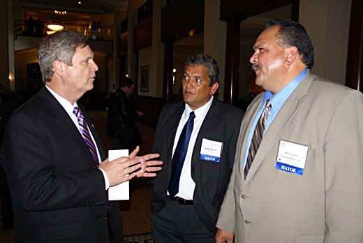
Image above: A heavily sweating Kauai Mayor Carvalho and Big Island Mayor Kenoi are being "man-splained" how GMO and pesticide policy will go down in Hawaii by Secretary of Agriculture Thomas Vilsack in a meeting in 2011. Vilsack was a former governor of Iowa and an early supporter of corn ethanol production. He had also been a lobbyist and Vice President of Monsanto corporation. Glyphoste is in his blood. From (https://damontucker.wordpress.com/tag/mayor-bernard-carvalho/).

Recently I received a mailing purportedly from Bernard Carvalho to "talk about Nui Kuapapa" - "to talk about our island". The mailing invited me to identify which moku I live in from a provided map of Kauai and Niihau. The map was first seen in the drafts of the proposed Kauai General Plan Update 2020.

http://www.islandbreath.org/2017Year/05/170514mokubig.jpg
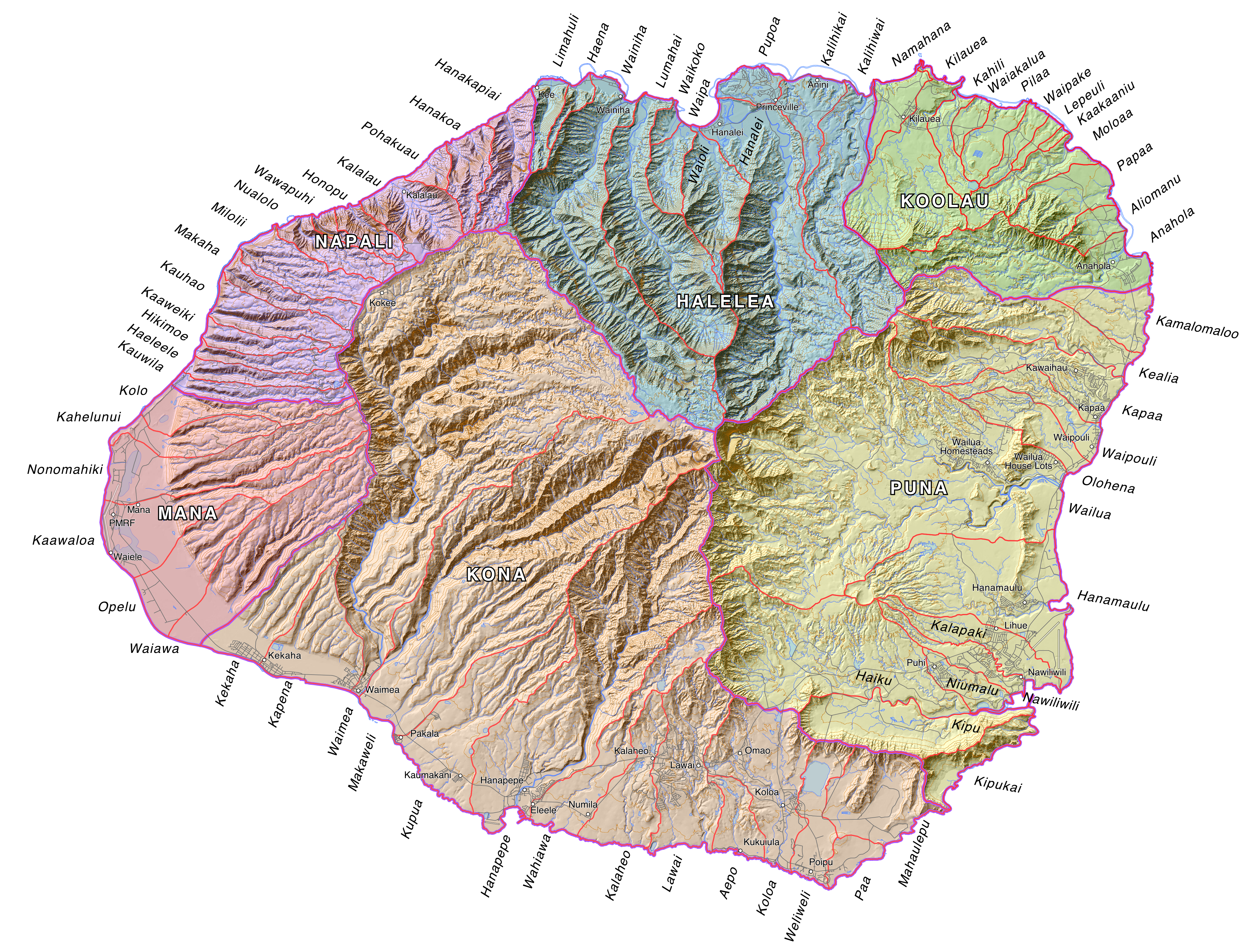
Image above: Map of Kauai and Niihau from the draft of the General Plan Update showing Niihau as a moku of Kauai and Kona moku flooding into half of the Napali moku from Haeleele to Nualolo. See also (http://kauainuikuapapa.com/moku/kona/).


Note, this map does conform to historic moku borders in some ways. Certainly Halelea, Koolau, and Puna are reasonable representations according to many, but not all cultural interpretations. As  in many modern maps no Mana Moku is shown. Mana is subsumed by Kona.

But in addition the Napali Moku has been shriveled by half as Kona has engulfed much of the western Napali ahupuaa from Haeleele to Nualolo, including Milolii. Since when has Milolii not been considered on the Napali Coast?

To see how shallow this cultural vision of Kauai is check out the source  (http://kauainuikuapapa.com/#home). The creators of this site are linked to the General Plan effort and reveal  something interesting when you get down to the contacts page:
Nā Hōkū Welo, LLC
P.O. Box 511
Līhue, HI 96766
Phone (808) 779-9454
Fax (855) 251-5425
partner@nahokuwelo.com

Nalani K. Brun
Economic Development Specialist IV-Tourism
Office of Economic Development
County of Kauai
4444 Rice St. Suite 200
Līhue, HI 96766
Phone (808) 241-4952
Fax (808) 241-6399
nbrun@kauai.gov
In my opinion, the map, as a part of the presentation of the entire General Plan Update Plan process, shares a false Hawaiian cultural patina. The map shows Kauai County - that is the islands of Kauai and Niihau. It show five moku on Kauai and show Niihau as a moku of Kauai. Moreover, the moku are not in conformance with the earliest Hawaiian maps prior to the introduction of private property.

The General Plan Update process pretends to be a gathering of our community voices to determine our future. It uses Hawaiian words to pretend it shares Hawaiian cultural perspective. It is presented in an informal style with lots of images of local people and places, but as merely props and scenery to disguise its true purpose - ECONOMIC DEVELOPMENT... particularly for tourism and real estate development.

Because this is a Kauai County government project it is seen from a county political perspective, Niihau has been reduced to an appendage of Kauai. 

From the get-go the County Planning Department has had the goal that the General Plan Update 2020 will implement a doubling of the population of Kauai in the next generation. It calls for a tripling of the population in the Hanapepe-Elelele area and a significant increase in military operations (and personnel) on the Westside.

Niihau is not a moku of Kauai!
Hawaiian language definitions, like English, are multidimensional. In general "moku" means a cut piece of something, and a "puni" means surrounded as by water.
Moku (Parker Hawaiian Dictionary)
 A district; a division of an island, as Kona on Hawaii, and Hana on Maui.
Mokupuni (Parker Hawaiian Dictionary)
The full form for island; that is, a division of land surrounded by water.
It is true that Kauai and Niihau were at one time part of a single larger island rivaling the Big Island and included the tiny island of Kaula further to the southwest of Niihau.  Niihau maybe politically part of Kauai County but it is a separate inhabited island and a mokupuni unto itself.

Maui has had a similar fate. At one time Maui was an island that included Molokai, Lanai and Kahoolawe. As it was eroded and broken into separate islands over geological time each part became a mokupuni unto itself.

But this is clear. All Hawaiian inhabited Hawaiian islands have an identified windward and leeward side (or Kona and Koolau moku).

Mana is a moku of Kauai!
Before I detail why, I must tell you I've been mapping the moku of Kauai for over a decade. In 2009 I was approached by Jean Ileialoha Beniamina to map the moku and ahupuaa of all the Hawaiian islands. She was then Chair of the Aha Kiole Committee (later to become the Aha Moku Council).

The committee and council sought kapuna and others with knowledge of historic Hawaiian land management and the names and places of moku and ahupuaa to report on each island.

I was commissioned by the Western Pacific Regional Fisheries Management Council (WesPac) through funds from the US National Ocean & Atmospheric Administration (NOAA) to do that mapping according to the reports of the Aha Moku Council.

In 2010 the maps I produced were accepted as complete. Some adjustments were made and corrections submitted by Ahu Moku participants and others who saw the maps once published and made available to the public. The results of that effort can be found at (http://www.islandbreath.org/mokupuni/mokupuni.html).

The Kauai map specifically can be found at (http://www.islandbreath.org/mokupuni/M7Kauai/M7KauaiRasterFile.png). The kauai and the other island maps can be found at the Aha Moku Council website here (http://www.ahamoku.org/index.php/maps/).

In studying the issues I came across two vital sources. One was Mrs. Ursula S. Emerson, the wife of minister Rev. John S. Emerson of Kauai. In conjunction with local Hawaiians she mapped Kauai, Niihau and Oahu.

Mokupuni O Kauai

Image above: The 1833 map of Kauai by Ursula Emerson, wife of Reverend John Emerson of Koloa. In my opinion this is the finest map of Kauai until four decades later. It had the best proportions features and selection of detail until after the overthrow of Hawaiian sovereignty. This copy came from the Kauai Historical Society. For some unaccountable reason the title block of the maps was mutilated. Click to enlarge and see full image.

This map of Kauai is dated 1833. Besides sailor's navigational maps, this is the first coherent map of Kauai. It identifies streams and renders interior valleys and ridges. The map also show the Great Ala Loa Trail and the ahupuaa and moku of the island.  I consider it the most accurate map of Kauai until after the Great Mahhele. It shows clearly six moku on Kauai, the westernmost one being Mana Moku. Her Kauai map was used a a basis for the US Navy and British Navy maps of the late 1830’s.

Mokupuni O Kauai
Image above:  Detail of the 1833 map of Niihau by Ursela Emerson. Click for complete map.

The Emerson map of Niihau distinctly identifies two moku - Kona and Koolau. It, like her map of Kauai, shows a detailed knowledge of shoreline, features and place names. Her maps were done in Hawaiian language and my understanding is that local Hawaiians were the source of her detailed knowledge of the islands.


Image above: Detail of Kauai island from 1838 map of Hawaiian Islands by S. P. Kalama.

Also, Simon Peter Kalama of Maui’s Lahaina Luna School was the first Hawaiian to map the Hawaiian Islands in 1837 and more accurately in 1838). He clearly shows Mana as a moku of Kauai and Niihau with a Kona and Koolau moku. See (http://islandbreath.blogspot.com/2010/06/na-mokupuni-o-hawaii-nei.html).


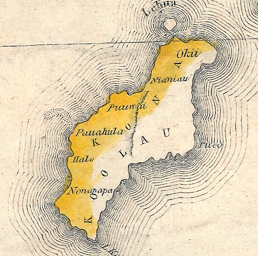
Image above: Detail of Niihau Island from 1838 map of Hawaiian Islands by S. P. Kalama 1838.  

It is not until well after the establishment of private property and the Hawaiian Government Survey map of 1878 did you see Mana as just an area of the westside of Kauai identified as the Moku of Waimea. That continued through the the Territory of Hawaii Map of 1901. Only later was area changed to be part Kona Moku.

I wrote to the partner at Nahokuwelo.com of this matter over a week ago saying I was prepared to work with him on the issues concerning Moku and Ahupuaa on Kauai and Niihau, needless to say, I got no reply.

If the cultural and historic confusion represented by the General Plan Update maps of moku on Kauai and Niihau are representative of the quality of the General Plan then woe be it unto Kauai and Niihau.

.

Introduction to Hawaiian Land Areas

SUBHEAD: This is a synthesis of the Hawaiian historical record combined with contemporary ecological frameworks.

By Juan Wilson & Jonathan Jay on 2 May 2016 for Island Breath-
(http://islandbreath.blogspot.com/2016/05/introduction-to-hawaiian-land-areas.html)


http://www.islandbreath.org/hawaiinei/M8Niihau/M8NiihauRasterFile.png

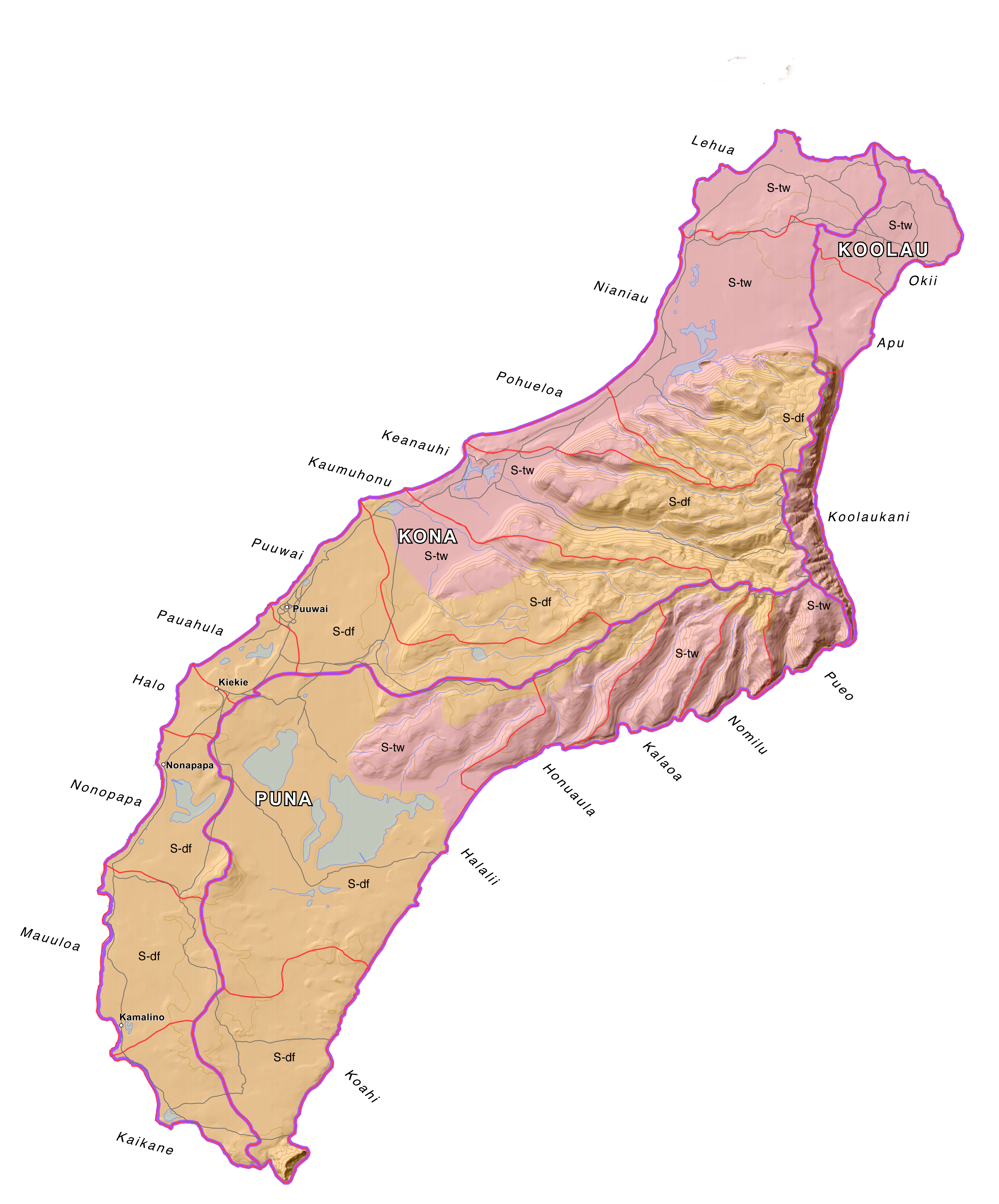
Image above: Map of Niihau, Hawaii, showing Life Zones, Ahupuaa and Moku. Click to enlarge.

By Juan Wilson
The traditional land divisions of pre-contact Hawaiians was based on the sustainability and self-reliance within community watershed areas (ahupuaa) as well as within bioregions (moku) and lastly individual sovereign islands (mokupuni). These natural land divisions were the result of the flow of water over the land.

We are now beginning to include evidence of the flow of water over and under the surface of the islands. We are calling these areas of consideration Waihona.

For simplicity and efficiency this current work is not being coordinated through the Ahu Moku Committee. Historic documents, reference material and selected kapuna are being consulted. On May 1st 2016 we released the current state of the work to the public.

We welcome comment and criticism. This work is far from complete. Waihona are only partially covered at this time.

The new work can be found by clicking here:
(http://www.islandbreath.org/hawaiinei/hawaiinei.html

The available downloadable files of Big Island, Maui, Kahoolawe, Lanai Molokai, Oahu, Kauai and Niihau are in the following formats:

GoogleEarth Files - .kmv
Arch D size Plot Files - .pdf
High Resolution Raster Files - .png
ArcView GIS Shape Files - .shp
AutoCad Document Exchage Files - .dxf

The older Ahu Moku work can be found here:
(http://www.islandbreath.org/mokupuni/mokupuni.html)


By Jonathan Jay
Although this work began as an inquiry into the existing historical cartographic documents and collected oral descriptions of the traditional and customary Ahupua`a and Moku land management system of the Polynesian and Hawaiian people, this work is now a synthesis of that historical record combined with contemporary Western ecological and environmental frameworks, adapted to existing present conditions.

As such, this work is no longer an attempt to accurately recreate the boundaries of ahupua'a or moku divisions at a particular point in history. Instead, by attempting to discern the principles and frameworks of understanding that allowed for the creation of organic divisions of land in the first place, we now strive to apply these principles to our contemporary conditions - 'Ahupua`a & Moku for the 3rd Millennium' if you will.  It is our hope that this work will provide the basis for prudent, long-range, sustainable land-use and resource management.


.

Kauai's PMRF is bang out of sight

SUBHEAD: The PMRF on Kauai and what the increasing military presence in the Pacific means for Hawaii and the world.

By Jon Letman on 26 June 2014 for Hawaii Independent -
(http://hawaiiindependent.net/story/pmrf-kauais-biggest-bang-is-out-of-sight)
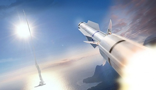

Image above: The Navy announced on 5/21/14 the first live-fire test of Raytheon's SM-3 landbased missile from the PMRF. It is a variation of Lockheed Martin’s Aegis missile defense system. From (http://www.inquisitr.com/1262375/with-successful-test-firing-of-sm-3-missile-us-inches-closer-to-advanced-defense-against-ballistic-missiles-attacks/).

When you think of Kauai perhaps you envision lush tropical foliage, hiking in Waimea Canyon or kayaking the Wailua River.

What you probably don’t think of are Advanced Hypersonic Weapons, Ballistic Missile Defense testing, Predator drones, low-earth orbit intercepts and sophisticated tracking systems that monitor activities around the globe.

Whale watching tourists sailing along Kauai’s famed Nā Pali Coast have no idea they are sharing the scenic waters with defense contractors Boeing, Raytheon, Lockheed Martin, Northrop Grumman and General Atomics, among others.

But just as Kauai is a major center for biotech companies (Syngenta, Dupont-Pioneer, Dow-AgroSciences, BASF), so is it a critical, albeit under-reported, testing and training hub for the U.S. military, the Defense Advanced Research Projects Agency (DARPA), NASA, the Missile Defense Agency (MDA) and Sandia National Laboratories which all conduct programs at the Pacific Missile Range Facility (PMRF).

Unlike Oahu, Kauai’s military presence goes largely unseen. Yet PMRF, which has nearly 75-year-old roots as an Army landing site, occupies a seven and a half by three-quarter’s mile wide swath of coast at Barking Sands on the edge of the Mānā Plain. This once marshy wetland, long ago drained to grow sugar cane, is today home to GMO crop fields that form a buffer around PMRF.

For most tourists and even many Kauai residents, PMRF remains terra incognita. Although PMRF is covered in the local Garden Island newspaper and the Honolulu Star-Advertiser, it’s rarely mentioned in national or international media unless there’s a major launch like the May 22 Aegis Ashore ballistic missile defense (BMD) test.

Recently, I had the chance to spend a few hours touring PMRF with its commanding officer Captain Bruce Hay as my guide. As part of its community outreach, PMRF’s public affairs officer invited me (along with two other local reporters) to see what goes on largely out of view and without scrutiny.

Going ‘Open kimono’
After a cafeteria-style lunch at PMRF’s Shenanigans café during which Capt. Hay promised our tour would be “open kimono,” we were led to his car—a Chevy Malibu as blinding white as his uniform. We piled in and were taken on a short drive to a 135-foot long rocket launch rail that resembled a grey steel bridge jutting out over the sand.

The captain described how the launch was designed to fire the Space-borne Payload Assist Rocket, also called Super Strypi—a collaborative project of Sandia National Laboratories, Aerojet Rocketdyne Corp., the University of Hawaii and PMRF. The main function of its first mission will be to demonstrate how to inexpensively deliver a 300-kilogram payload into low-earth orbit.

For the project’s partners, Super Strypi represents not only a technical achievement but an educational opportunity as private and public sectors push to advance Hawaii’s position in the world of the aerospace and defense industries.

Launching a rocket—any kind of a rocket—at PMRF is for Hay “pretty neat.” Over the course of the two and a half hour tour, he repeatedly expressed his enthusiasm for involving children in launches (as observers), whenever possible. It’s all part of PMRF’s—and more broadly, the aerospace and military defense industry’s—enthusiasm for supporting STEM (Science, Technology, Engineering and Math) education.

Not just Kauai
Contrary to popular belief, PMRF is not limited to Kauai’s Mānā Plain. The range also includes “small installation” sites at Kokee State Park, Mākaha Ridge, Kamokala Ridge, Port Allen, Mauna Kapu on Oahu, Pōhakuloa Training Area on Hawaii Island and the privately-owned island Niihau which is home to a “perch site” comprised of a helicopter pad, electronic warfare equipment and surveillance radar.

Less than two dozen miles south of Niihau is Kaula, a steep offshore islet inhabited by bird colonies. Like Kahoolawe island and Pagan island in the Northern Marianas, part of Kaula is being used for “intert air-to-surface weapons” testing. Unlike Kahoolawe and Pagan, however, there is effectively no protest or even knowledge that this island is being used.

As we drove from one site to the next, Hay pointed out that Kaula’s ownership is in question. “Is it the Federal Government? Is it the Department of Defense? Is it the State of Hawaii? I don’t know. I’m not a lawyer—thank God,” he quipped.

“We expect use to go up as all the forces that were in the desert for the last 20 years are starting to flow back to bases in the United States. Marines, Air Force and Army are all coming back,” he said then, without missing a beat, pointed out a playing field visited by pro football players last year.

One of PMRF’s greatest assets Hay has said previously, is the fact that it has a whole lot of nothing.

That “nothing” is, in fact, over 2.1 million square miles of “extended range” roughly the size of the continental United States west of the Mississippi including Baja, Mexico. This is in addition to 1,100 square miles of “instrumented sea range” and 42,000 square miles of “controlled airspace.”
From Hay’s perspective, conducting testing and training west of Kaua‘i means the military is not impacting shipping lanes or civilian air traffic. Critics, however, are increasingly challenging environmental impacts, particularly the use of high-frequency sonar and its alleged impact on marine life from deep water corals to large marine mammals.

Out in that vast watery “nothingness” PMRF operates MATSS (Mobile-At-Sea-Sensor system)—a barge loaded with antennae, telemetry tracking dishes and equipment used to support BMD testing. Hay noted that when the crew is waiting to support training exercises, there’s plenty of time to cast rods and “have some beautiful ahi sashimi.”

Base Living
PMRF touts itself as an important economic driver on Kaua‘i, proudly describing its role in employing local people. According to Hay, the base employs around one thousand (770 contractors, tenants and other service providers, 140 civilian and 87 military officers/enlisted). Currently about 150 people live on base in some 50 modest housing units.

Although PMRF has many of the amenities you’d find in a small town (gas station, car wash, barber shop, post office, an outdoor theater, Subway sandwich outlet, parks and recreational sports facilities), it doesn’t feel like your average civilian town. Maybe it was the Regulus cruise missile mounted on display, but the place just feels like a military base which, of course, it is.

Driving along PMRF’s almost carless roads, we slowed down to look at roadside tanks. Hay said the dummy tanks—called “composites”—are used for pilot training. The tanks aren’t fired at with live ammunition but they can provide a realistic training object particularly when equipped with heat generators that simulate a real “live” target.

“You know, we do all kinds of cool testing and training on base,” the captain said, “but I get more questions about these than anything else.” He was referring to the 26 seaside guest cabins (for retired and active duty military personnel) just two minutes walk from the longest continuous beach in the Hawaiian islands. If you know someone on base, he explained, “they can hook you up.”

‘The Roc’
Next we stopped at an unremarkable beige building which Hay identified as his primary working headquarters—the Range Operations Complex or “the Roc.” Hay led us to a Standard Missile Three (SM-3) displayed on a mount behind a plaque that reads “Ad Astra Per Aspera” (“To the stars through adversity”).

The SM-3 (manufactured by Raytheon which describes it as “the world’s only ballistic missile killer deployable on land or at sea”), Hay explained, is designed to “engage non-air-breathing ballistic missile targets.” In other words, the SM-3 is intended to be fired at an incoming enemy missile and destroyed mid-air by sheer kinetic force. It’s the “kill vehicle,” Hay explained, gesturing to the rocket’s 21-inch tip, that matters most.

“It’s pretty neat to think we are hitting a bullet with a bullet,” Hay said, referring to the 21-foot 6-inch long white priapic missile behind him.

Hay described ballistic missile defense as “very successful, in the low nineties” but a recent Los Angeles Times investigation found that the Boeing-manufactured $40 billion Ground-based Midcourse Defense system, tested at PMRF-partnering facility Vandenberg Air Force Base in California was “unreliable, even in scripted tests.” One physicist at Lawrence Livermore National Laboratory called the system’s test record “abysmal,” the Times reported.

Speaking about BMD testing at PMRF Hay said, “When we do a live engagement, we’re going to shoot towards Kauai, not at Kauai. That’s an important distinction.”

Aegis Ashore
Meanwhile, other ballistic missile defense systems are tested at PMRF, most notably Aegis Ashore.
PMRF has a long history of supporting missile defense testing. One of the most high-profile systems being tested today is Aegis Ashore. Essentially identical to the BMD system deployed on Aegis naval destroyers, Aegis Ashore is designed for use on land.

A product of Lockheed Martin, Raytheon, the U.S. Navy and the Missile Defense Agency, Aegis Ashore, was championed by the late Senator Daniel Inouye and is slated for deployment in Romania in 2015 and Poland in 2018.

As Capt. Hay pulled up in front of a dull, white building topped with radar antenna equipment behind a high black fence topped with barbed wire he said, “If you’re familiar with ships, it looks a lot like a Ticonderoga Class (guided missile) cruiser.” He explained that Aegis on a ship requires 300-400 people to operate. “Take a stab at how many sailors run this facility,” he said.
“Fifteen?” I guessed.

“Less, but not much. Twelve sailors and a few contractors,” he replied. According to Hay, Aegis Ashore is cheaper but still expensive. The building alone (Aegis Ashore Missile Defense Test Complex) cost $60 million. Once fitted with all radar and other equipment, that cost soared to $700 million. On a ship, Hay said, that would be around $2 billion even before crew salaries and fuel.
Aegis Ashore, he said, “gives you an opportunity to do that at much less cost.”

The first Aegis Ashore test took place at PMRF just three days before my visit and made news for the mysterious vapor trails it left behind, but the real news no one seems to talk about in Hawaii is how Kauai is at the center of a BMD system which the Obama administration insists is to protect Europe from Iran but whose deployment has been repeatedly and angrily criticized by Russia.

Now, with the backdrop of increased tensions between the U.S., NATO and Russia resulting from Moscow’s annexation of Crimea and fighting in Ukraine, far-off Kauai’s own role in global military conflicts is underscored.

When I asked Capt. Hay who Aegis Ashore is intended to defend against he declined to name names, instead saying, “Think of all the antagonists all throughout Europe and the Middle East.”

Asked how the schedule deployment was being received Hay said, “The former Soviet Union wasn’t too crazy about it, for obvious reasons. But by and large it’s been a non-issue.” I did not ask how the U.S. would respond to a Russian BMD deployment in Mexico, Canada, or Cuba.

Big things for important people
Kauai’s Garden Island newspaper recently reported that PMRF is pushing forward a proposal to be renamed as the Inouye Pacific Range Facility in honor of the Senator Daniel Inouye who served in Congress for over 53 years. Over his career Inouye funneled billions in defense contracts to Hawaii, making it the defense, military and aerospace juggernaut it is today. Hay said, “[Inouye] was a great advocate and champion for the range.”

While the name change may be a show of respect for Inouye, it’s also an example of shrewd branding. Inouye is revered in Hawaii and will remain so for years. To replace the word “missile” with “Inouye” is, in a sense, to put the facility beyond reproach. After all, PMRF could change its name to the Inouye Pacific Missile Range and drop the superfluous word “facility.”

PMRF is “not just ballistic missile testing,” Hay pointed out in an interview with the Garden Island newspaper last year, “…We’re doing big things for very important people all across the globe.”

“Big things” presumably include supporting UAV (Unmanned Aerial Vehicle) or drone testing and training for systems like the MQ-9 Reaper, MQ-1 Predator, the high-altitude capable ALTUS II as well as NASA research aircraft and other UAV systems like the Coyote and the Cutlass V. PMRF has also seen visiting F-16s, F-18s, C-17s, P-3s, E-2s and the V-22 Osprey, a hybrid aircraft with a checkered safety record and the object of ongoing protests in Okinawa where it is deployed.

Doing “big things for very important people” also means hosting the Kauai Test Facility (KTF), operated by Sandia National Laboratories. Sandia, a wholly owned subsidiary of Lockheed Martin, is one of the United States’ three primary nuclear weapons laboratories. KTF was established on Kauai as a tenant inside the PMRF in 1962 to support the Atomic Energy Commission’s Operation Dominic which included a series of 36 high-altitude nuclear weapons tests in the Pacific.

In November 2011 KTF was the launch site of the Advanced Hypersonic Weapon (AHW), a missile that is intended to fulfill the goal of a “Prompt Global Strike,” a directive that would enable the U.S. to bomb anywhere on earth in under 60 minutes. In the November 2011 test, the AHW was fired from Kauai, arriving at the Reagan Test Site on Kwajalein Atoll in the Marshall Islands, about 2,500 miles away, in 30 minutes. The Army has reported another test is scheduled for August.

Since its inception in 1962, KTF has supported 437 rocket launches (as of May 2014), making it—and its host PMRF—major players in a militarized Pacific.

When asked directly if nuclear weapons or components of nuclear weapons have ever been stored or passed through PMRF, a spokesman replied, “Per Department of Defense policy, all U.S. military installations can neither confirm nor deny the presence of nuclear weapons.”

Rim of the Pacific
This summer (June 26 through August 1) 23 nations are converging on Hawaii for the RIMPAC (Rim of the Pacific) 2014 biennial maritime exercise. While the war games include countries as diverse as India, China, Singapore, Norway and Tonga and Japan, the participants page of RIMPAC’s website shows the U.S. military is overwhelmingly represented.

Speaking on Kauai’s KKCR radio recently, Capt. Hay pointed out that RIMPAC includes things “as benign as sports competitions…receptions, dialogues,” saying that RIMPAC helps ensure “we can all enjoy the giant Pacific Ocean.”

RIMPAC also provides a chance to show off the latest military technology, gadgetry and test systems like drones (during RIMPAC 2012 a submarine launched drone was tested) and practice live fire sinkings on decommissioned ships in an exercise called SINKEX (Sinking Exercises, planned between July 12-18 during RIMPAC 2014).

Besides this, RIMPAC provides a realistic setting for urban combat training, amphibious landings, under water sonar training and a host of other military exercises. A spokesman confirmed that PMRF will provide “subsurface, surface and air training capabilities. Ships, submarines and aircraft [will] train on an instrumented range … off the northwest shores of Kauai.”

Not "the" base, "our" base
Kauai may be only 35 square miles larger than the city of Phoenix with less than five percent of its population, but thanks to PMRF, it plays an outsized role in America’s ability to wage wars, control the seas, skies and space and ensure that the U.S. military juggernaut can continue in its quest to maintain Full-spectrum Dominance. Like RTS in the Marshall Islands and Vandenberg Air Force Base (California), PMRF is a key spoke in the military missile testing arsenal.

At the end of the tour, Captain Hay drove us to the gate, thanked us and said that he hoped when people on Kauai spoke about PMRF they wouldn’t talk about “the base” but rather “our base.”

As I drove away, passing the surrounding fields, a hard rain began to fall and I reflected. If PMRF is our base, then it is also our kuleana (responsibility) to understand what goes on inside and to make the connections between it and events around the world.

Militarism and war do not take place in a vacuum. What happens here affects people around the world. It is incumbent on us to closely follow what our base is doing beyond the occasional headline rocket launch or star-spangled hoopla of Fourth of July fireworks.

We need to understand that our base impacts lives in far away places, from the dun-colored hills of Afghanistan and the war-torn cities of Syria and Iraq to the shallow blue lagoons of Micronesia’s coral atolls and the gritty urban landscapes across the U.S. where many veterans end up after war.
Each of us must ask ourselves if our base is pursuing our values, and on a course that is in our best long-term interests.


See also:
Ea O Ka Aina: The Pacific Pivot 6/28/14
Ea O Ka Aina: RIMPAC IMPACT 6/8/14
Ea O Ka Aina: RIMPAC Then and Now 5/16/14
Ea O Ka Aina: Earthday TPP Fukushima RIMPAC 4/22/14
Ea O Ka Aina: The Asian Pivot - An ugly dance 12/5/13
Ea O Ka Aina: Help save Mariana Islands 11/13/13
Ea O Ka Aina: End RimPac destruction of Pacific 11/1/13 
Ea O Ka Aina: Moana Nui Confereence 11/1/13
Ea O Ka Aina: Navy to conquer Marianas again  9/3/13
Ea O Ka Aina: Pagan Island beauty threatened 10/26/13
Ea O Ka Aina: Sleepwalking through destruction 7/16/12
Ea O Ka Aina: Okinawa breathes easier 4/27/12
Ea O Ka Aina: Navy Next-War-Itis 4/13/12
Ea O Ka Aina: America bullies Koreans 4/13/12
Ea O Ka Aina: Despoiling Jeju island coast begins 3/7/12
Ea O Ka Aina: Jeju Islanders protests Navy Base 2/29/12
Ea O Ka Aina: Hawaii - Start of American Empire 2/26/12
Ea O Ka Aina: Korean Island of Peace 2/26/12   
Ea O Ka Aina: Military schmoozes Guam & Hawaii 3/17/11
Ea O Ka Aina: In Search of Real Security - One 8/31/10
Ea O Ka Aina: Peace for the Blue Continent 8/10/10
Ea O Ka Aina: Shift in Pacific Power Balance 8/5/10
Ea O Ka Aina: RimPac to expand activities 6/29/10
Ea O Ka Aina: RIMPAC War Games here in July 6/20/10
Ea O Ka Aina: Pacific Resistance to U.S. Military 5/24/10
Ea O Ka Aina: Guam Land Grab 11/30/09
Ea O Ka Aina: Guam as a modern Bikini Atoll 12/25/09
Ea O Ka Aina: GUAM - Another Strategic Island 11/8/09
Ea O Ka Aina: Diego Garcia - Another stolen island 11/6/09
Ea O Ka Aina: DARPA & Super-Cavitation on Kauai 3/24/09
Island Breath: RIMPAC 2008 - Navy fired up in Hawaii 7/2/08
Island Breath: RIMPAC 2008 uses destructive sonar 4/22/08
Island Breath: Navy Plans for the Pacific 9/3/07
Island Breath: Judge restricts sonar off California 08/07/07
Island Breath: RIMPAC 2006 sonar compromise 7/9/06
Island Breath: RIMPAC 2006 - Impact on Ocean 5/23/06
Island Breath: RIMPAC 2004 - Whale strandings on Kauai 9/2/04
Island Breath: PMRF Land Grab 3/15/04


.
It's all about the drones

SUBHEAD: It's the military/industrial drone program coming to Hawaii that is driving separation of Kauai and Niihau.

By Juan Wilson on 11 February 2014 for Island Breath -
(http://islandbreath.blogspot.com/2014/02/its-all-about-drones.html)

http://www.islandbreath.org/2014Year/02/140211dronebig.jpg
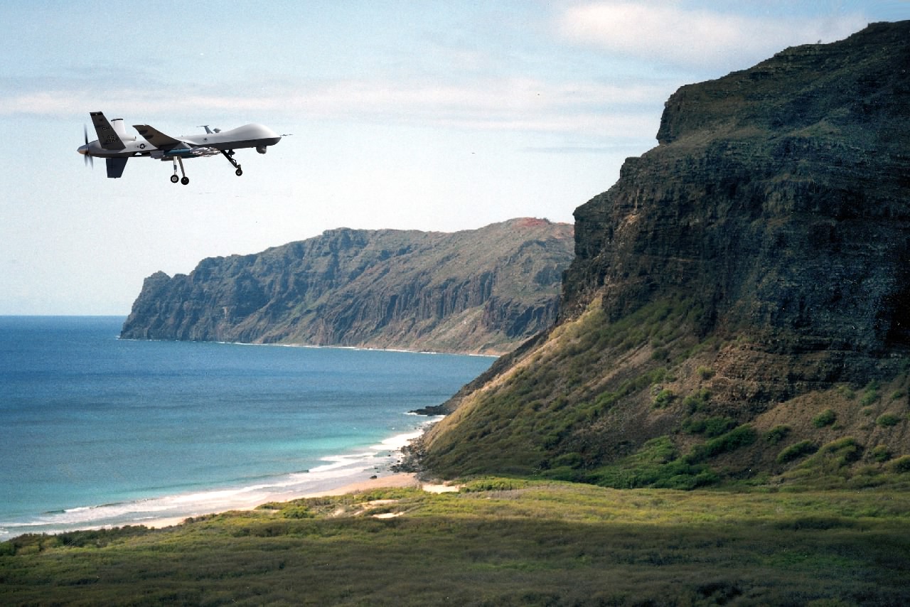
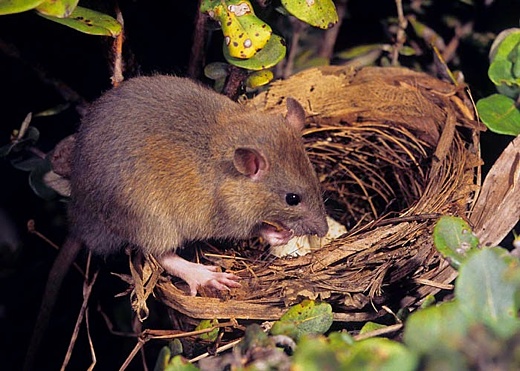
Image above: Mashup by Juan Wilson of drone over the Apu ahapuaa in the Koolau moku of northeast Niihau. Click to embiggen.

The ugly shape in the darkness is revealing itself as people turn their attention to recent news concerning Niihau.

It would seem there has been a stealthy program to beef up the military presence here in Kauai County - specifically to add Niihau to the area controlled through the Pacific Missile Range Facility (PMRF). The PMRF already has rights on 6,000 acres of the Mana Plain through leases with the DLNR and non-exclusive easement arrangements. Moreover, beyond Kauai they "coordinate" one million square miles of range in the Pacific Ocean.

The issue is not about picking opihi, or nearshore fishing rights, or private property rights, or Aha Moku konhiki responsibilities, or Hawaiian cultural values, or increasing  PMRF basesecurity, or separating Niihau from Kauai County.

This is about a play by the federal government to orchestrate the inclusion of Niihau as a part of US military operations here. Stakeholders in the drama (wittingly or unwittingly)  include the US Department of Defense, US Navy, PMRF, several military contractors, Governor Abercrombie, members of the Hawaii legislature, the DLNR, Aha Moku Council, and some Hawaiian cultural practitioners.

Just remember, every other even numbered year is another RIMPAC exercise, and this year is RIMPAC 2014. There are some saying the channel between Kauai and Niihau is similar to the space at the Straights of Hormuz that separates the Arab Gulf States from Iran, ans here the bulk of Middle East oil must pass to reach the world - What better simulation area for practicing WWIII?

See also:
Ea O Ka Aina: Two bills to rule Niihau 2/9/14
Ea O Ka Aina: Niihau and the US Military 2/7/14
Ea O Ka Aina: End RimPac destruction of Pacific 11/1/13
Ea O Ka Aina: Navy admits threat to sea mammals 5/12/12
Ea O Ka Aina: RIMPAC to Expand Activities 8/3/10
Ea O Ka Aina: RIMPAC War Games here in July 6/21/10
Ea O Ka Aina: RIMPAC to return in 2010 5/2/10
Island Breath: RIMPAC blaimed for beaked whale's death 7/29/08
Island Breath: RimPac 2008 7/2/08 
Island Breath: Protection of whales from Navy sonar 6/3/07
Island Breath: RIMPAC 2006 Impact 7/9/06
Island Breath: RIMPAC Threatens Kauai Again 5/23/06
Island Breath: RIMPAC 2004 Strandings 9/2/04


Keeping the islands one

By Chris D'Angelo on 9 February 2014 for the Garden Island -

(http://thegardenisland.com/news/local/govt-and-politics/keeping-the-islands-one/article_35834f64-915e-11e3-afae-0019bb2963f4.html)

By now, it is no secret that the Robinson family and a handful of Hawaii legislators have major plans for the “Forbidden Island” of Niihau.

A slew of bills have been introduced this legislative session related to the island — proposals from establishing no-fishing zones and regulating the harvesting of opihi in nearshore coastal waters to making the privately owned piece of land a new, independent county from Kauai.

On Friday, Kauai community members came out in force at Wilcox Elementary School to make it clear that they feel they’re being left out of the discussions.

“This whole bill thing for Niihau just absolutely stinks,” said Don Moses, a 40-year Kauai fisherman.

The crowd of more than 100 was united in its stance.

“They are being rushed through without hearings, which seems very unfair,” Puanani Rogers added of the bills. “What is the rush? Is it because the Robinsons have an ulterior motive?”

Dan Ahuna, the Kauai and Niihau trustee for the Office of Hawaiian Affairs, said he organized the “listening session” to make sure all Hawaiian beneficiaries are being heard on the matter.

“Two days ago, in one of our OHA Board of Trustee meetings, a procedural vote came up and I was put in a situation to support a vote to write a letter to the governor and support this bill for (banning fishing) three miles out,” he said. “But it is important for me to be here to listen to you and your comments.”

While he feels he has been put in an “unfortunate situation,” Ahuna said he wants to move forward with open dialogue.

In attendance Friday was Rep. Faye Hanohano, who introduced the House version of a bill that would have established a two-mile no-fishing zone around the island. That bill was ultimately deferred and Hanohano has since introduced a short form bill, SB 709, that would make appropriations to the state Department of Land and Natural Resources to conduct public outreach meetings to adopt rules for statewide coastal management.

“The problem is not only on Kauai and Niihau,” she said.

Rep. Dee Morikawa, who was also in attendance, said Hanohano’s bill is a compromise.

“Her bill is what brings everybody to the table,” she said. “So that’s what we want you to know. It’s not getting shoved down your throat. If we can get her bill passed, we can get everybody on the table to figure out what we’re going to do about this.”

More than a dozen people took the opportunity to voice their feelings. One resounding message was that Kauai and Niihau are one and should not be separated — neither as counties nor fishing areas.

Westside fisherman Greg Holtzman described the two islands as “brother and sister,” and a relationship the state clearly doesn’t understand.

Before any decisions are made in regard to Niihau, Rogers said there needs to be many more community discussions.

“In my eyes, Niihau and Kauai are not separated,” she said. “We are one. We share the same ocean, we share the resources, we share ohana.”

The concerns voiced during the meeting varied greatly. Some said the bills are nothing more than the Robinson family trying to further privatize their already private island. Others said they are worried that the Niihau people are having their voices suppressed.

As for bringing everyone to the table, many questioned why the Robinsons didn’t attend the meeting. Shane Cobb Adams, however, said it’s not the Robinsons that should be included, but the people of Niihau.

“The people on Niihau have rights, and nobody’s asking them what they want,” he said.

If passed, SB 172 would make the island of Niihau a separate county under the control of the DLNR.

Mel Wills, operations manager at Holoholo Charters, said his concerns with the recent proposals vary greatly. One concern is that the DLNR, which issues his company boating permits, has been unable to enforce the law when it comes to illegal boaters.

While against fishing bans and the separation of counties, many in the audience seemed to be on board for Hanohano’s bill to appropriate money to the DLNR to study the issue.

Moses said it is time for fishermen and other interested parties on Kauai to organize and fight together so that the end result is a win-win for everyone, not just the Robinson family.

“We have to be one voice, one group that represents a lot of people that vote because that’s the only people they listen to,” he said of legislators.

Last to share his thoughts was Mayor Bernard Carvalho Jr., who expressed his disappointment with the flurry of bills, particularly the last-minute one to separate Niihau from Kauai.

“What’s up with that?” he asked. “We are the county of Kauai and Niihau, Niihau and Kauai.”

Carvalho added that fishing is everyone’s right and that Friday’s discussion was overdue.

“We got to be able to talk,” he said.


Responsive to local "stakeholders"

SUBHEAD:  The FAA expects that public entities will be "responsive" to stakeholder concerns.

By Lyn McNutt on 10 February 2014 in Island Breath -

Regarding the situation on the ground needed for FAA approval of US Drone Test Sites:

BINGO!  Here is the notice in the federal register (http://www.gpo.gov/fdsys/pkg/FR-2013-11-14/pdf/2013-27216.pdf).

Second, the FAA believes that Test Sites operators will be responsive to local stakeholders’ privacy concerns and will develop privacy policies appropriately tailored to each Test Site. The selection criteria for the Test Sites specify that only a ‘‘public entity’’ can serve as a Test Site operator. The term ‘‘public entity’’ is defined in the selection criteria to mean
(A) any State or local government;

(B) any department, agency, special purpose district, or other instrumentality of a State or States or local government;

(C) the National Railroad Passenger Corporation, and any commuter authority.
 The FAA expects that public entities will be "responsive" to stakeholder concerns.


Hawaii offers exceptional opportunities 

SOURCE: Lyn McNutt (zensea1@gmail.com)
SUBHEAD: Alaska among six sites selected by FAA for cutting-edge drone research.

By Mary Kauffman on 30 December 2014 for Sit News -
(http://www.sitnews.us/1213News/123013/123013_test_sites.html)

The "drones" are coming to Alaska (and Hawaii) - research that is. The University of Alaska will serve as one of six official Federal Aviation Administration unmanned aircraft system test sites, the federal agency announced today.

According to the FAA, the University of Alaska's proposal was chosen making Alaska one of the six test sites joining Nevada, New York, North Dakota, Texas and Virginia as testing grounds for unmanned aircraft systems (UAS). The Alaska-led team includes state agencies and companies in Oregon and Hawaii who joined Alaska's effort. In total, 58 companies and companies are part of the Alaska-led effort, according to ACUASI's Greg Walker of the University of Alaska.

“The University is both honored and challenged with this selection,” Ro Bailey, Deputy Director, Alaska Center for Unmanned Aircraft Systems at University of Alaska Fairbanks, said. “The benefits for the state, for its citizens, for business and technology, and for the nation are exciting and potentially very dramatic.”

“The University of Alaska Fairbanks’ reputation as an experienced, safe and savvy operator using a variety of UAS types in diverse missions and locations all over the globe undoubtedly played a major part in our selection,” said Ro Bailey, deputy director of ACUASI and the intended Pan-Pacific UAS Test Range Complex director.

“Alaska, Oregon and Hawaii offer exceptional climatic and geographic diversity, lightly populated airspace and overwater test opportunities that can support the majority of FAA needs.”

The Pan-Pacific UAS Test Range Complex will be managed by the University of Alaska Fairbanks and the test site will build on the ongoing work of the Alaska Center for Unmanned Aircraft Systems Integration, which is part of the UAF Geophysical Institute. Operations of the test range complex are slated to begin in mid-2014.

The Federal Aviation Administration (FAA) announced today the selection of the six public entities that will develop unmanned aircraft systems (UAS) research and test sites around the country. These congressionally-mandated test sites will conduct critical research into the certification and operational requirements necessary to safely integrate unmanned aircraft systems (UAS) into the national airspace over the next several years.

Today, unmanned aircraft systems (UAS) perform border and port surveillance, help with scientific research and environmental monitoring, support public safety by law enforcement agencies, help state universities conduct research, and support various other missions for government entities.

In selecting the six test site operators, the FAA considered geography, climate, location of ground infrastructure, research needs, airspace use, safety, aviation experience and risk. In totality, these six test applications achieve cross-country geographic and climatic diversity and help the FAA meet its UAS research needs.

Across the six applicants, the FAA stated in a press release it is confident that the agency’s research goals of System Safety & Data Gathering, Aircraft Certification, Command & Control Link Issues, Control Station Layout & Certification, Ground & Airborne Sense & Avoid, and Environmental Impacts will be met.

“These test sites will give us valuable information about how best to ensure the safe introduction of this advanced technology into our nation’s skies,” said Transportation Secretary Anthony Foxx.

The FAA’s role in the UAS program is to help the test site operators set up a safe testing environment and to provide oversight that ensures the sites operate under strict safety standards.

“Safety continues to be our first priority as we move forward with integrating unmanned aircraft systems into U.S. airspace,” said FAA Administrator Michael Huerta. “We have successfully brought new technology into the nation’s aviation system for more than 50 years, and I have no doubt we will do the same with unmanned aircraft.”

The FAA has established requirements for each test site that will help protect privacy. The requirements were developed with public input and the final requirements were published on November 14, 2013 in the Federal Register. This followed the February Federal Register notice that asked for public comments on the draft privacy requirements for the six test site operators. Among other requirements, test site operators will be required to comply with federal, state, and other laws protecting an individual’s right to privacy; have publicly available privacy policies and a written plan for data use and retention; and conduct an annual review of privacy practices that allows for public comment.

Alaska Lt. Governor Mead Treadwell welcomed the announcement that the Federal Aviation Administration chose Alaska as one of six states to be a test bed to integrate unmanned aerial vehicles (UAVs) or remotely piloted aircraft into civil airspace.

Treadwell is chair of the Aerospace States Association, which has advocated for the FAA's test bed program, and has helped Alaska and other states address privacy and constitutional issues related to UAVs.

"UAVs can help save lives, and promote scientific research and resource development here in Alaska," Treadwell said. "An unmanned vehicle can fly through volcanic ash clouds and into forest fires where it is not safe to send humans. They can provide observational warnings about marine mammals approaching offshore oil and gas fields. In a state as vast as Alaska, UAVs can give us information on what's happening with weather, climate, and other conditions in remote parts of our state.

"Safety and maintaining individual privacy continue to be our priority, and we're working to ensure they are never compromised," Treadwell said. "Alaska was a test bed for the next generation of air traffic control being adopted across the country. The FAA has learned Alaska airspace is a good place to advance safety for the nation."

Lt. Gov. Treadwell said many individuals and groups came together to support the Alaska proposal, made by the University of Alaska's Geophysical Institute's Alaska Center for Unmanned Aerial Systems Integration (ACUASI). An Alaska UAS Interest Group, organized by the State of Alaska, the U.S. Department of the Interior in Alaska, the FAA and the University, has hosted an annual workshop for the last seven years to help prepare for the new technology here.

U.S. Senator Mark Begich (D-AK) also welcomed the announcement that Alaska was chosen by the Federal Aviation Administration as one of the test sites.

“I fought hard to include funding for this research in the FAA bill because this kind of cutting-edge research will bring jobs, resources and a new mission to the University of Alaska system,” Begich said. “This new initiative will help lay the foundation for other new economic activity in Alaska and put our state on the world map when it comes to this exciting emerging technology.”

For years Begich has argued that Alaska is perfectly positioned for such research and development, given the state’s enormous airspace and challenging weather and temperature conditions.

Representative Shelley Hughes, who co-chairs the State House legislative task force for unmanned aircraft systems, congratulated the University of Alaska Fairbanks for being selected and pointed out the timeliness of the task force’s work.

“Our members have diligently been reviewing the state’s responsibility regarding privacy concerns, and we’ll be bringing forward recommendations to the legislature to provide a safeguard to the public,” Hughes said. “Alaska continues to be a leader in aviation, and this is the next wave. It makes sense to use UAS for the dull, dirty, and dangerous tasks.”

A brief description of the six test site operators and the research they will conduct into future UAS use are below:

University of Alaska. The University of Alaska proposal contained a diverse set of test site range locations in seven climatic zones as well as geographic diversity with test site range locations in Hawaii and Oregon. The research plan includes the development of a set of standards for unmanned aircraft categories, state monitoring and navigation. Alaska also plans to work on safety standards for UAS operations.

State of Nevada. Nevada’s project objectives concentrate on UAS standards and operations as well as operator standards and certification requirements. The applicant’s research will also include a concentrated look at how air traffic control procedures will evolve with the introduction of UAS into the civil environment and how these aircraft will be integrated with NextGen. Nevada’s selection contributes to geographic and climatic diversity.

New York’s Griffiss International Airport. Griffiss International plans to work on developing test and evaluation as well as verification and validation processes under FAA safety oversight. The applicant also plans to focus its research on sense and avoid capabilities for UAS and its sites will aid in researching the complexities of integrating UAS into the congested, northeast airspace.

North Dakota Department of Commerce. North Dakota plans to develop UAS airworthiness essential data and validate high reliability link technology. This applicant will also conduct human factors research. North Dakota’s application was the only one to offer a test range in the Temperate (continental) climate zone and included a variety of different airspace which will benefit multiple users.

Texas A&M University – Corpus Christi. Texas A&M plans to develop system safety requirements for UAS vehicles and operations with a goal of protocols and procedures for airworthiness testing. The selection of Texas A&M contributes to geographic and climactic diversity.

Virginia Polytechnic Institute and State University (Virginia Tech).Virginia Tech plans to conduct UAS failure mode testing and identify and evaluate operational and technical risks areas. This proposal includes test site range locations in both Virginia and New Jersey.

On November 7,2013, the FAA released its first annual Roadmap outlining efforts needed to safely integrate UAS into the nation’s airspace system. The Roadmap addresses current and future policies, regulations, technologies and procedures that will be required as demand moves the country from today’s limited accommodation of UAS operations to the extensive future integration of UAS into the NextGen aviation system.
As required in the 2012 FAA Reauthorization, the Joint Planning and Development Office has developed a comprehensive plan to safely accelerate the integration of civil UAS into the national airspace system. That plan details a multi-agency approach to safe and timely UAS integration and coordination with the NextGen shift to satellite-based technologies and new procedures.

On the Web:

FAA's first annual Roadmap http://www.faa.gov/about/initiatives/uas/media/UAS_Roadmap_2013.pdf

Joint Planning and Development Office developed a comprehensive plan to safely accelerate the integration of civil UAS into the national airspace system, for more information...
http://www.faa.gov/about/initiatives/uas/

Source of News:

Federal Aviation Admin. (FAA)
www.faa.gov

Lt. Gov. Mead Treadwell
ltgov.alaska.gov

U.S. Senator Mark Begich
www.begich.senate.gov

Alaska House Majority Caucus
akleg.gov

University of Alaska Fairbanks
uaf.edu


.