Showing posts with label Restoration. Show all posts

Maui conservation effort working

SUBHEAD: Large landscape scale reforestation at Auwahi on Haleakala is proof.

By Jan TenBruggencate on 21 July 2017 for Raising Islands-
(http://raisingislands.blogspot.com/2017/07/landscape-scale-conservation-can-work.html)
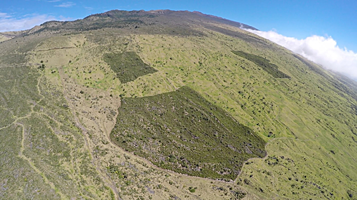
http://www.islandbreath.org/2017Year/08/170803auwahibig.png
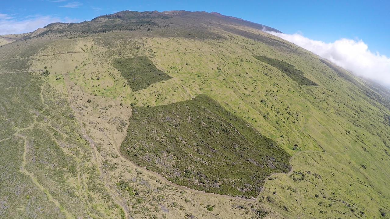
Image above: Southern flank of southwest Maui where Auwahi reforestation project is turning Haleakela green. From original article. Click to enlarge.

When Art Medeiros fenced some Maui pasture that had a smattering of native dryland forest plants on it, most folks figured he was engaged in a pipe dream.

He hoped that by excluding deer and cattle, and with a little loving care and some outplanting, something approaching a healthy native dryland forest could result.

Medeiros was right. The image above is the proof. The three dark green patches are areas fenced to keep grazing animals out and then planted with dryland natives. The 10-acre center square was fenced and planted 20 years ago, the bottom 23 acres 12 years ago, and the 23-acre shape at the right eight years ago.

Medeiros worked with the landowners, `Ulupalakua Ranch’s Erdman family, along with the U.S. Fish and Wildlife Service and the Natural Resources Conservation Service, to form the Auwahi Forest Restoration Project. You can learn more about it at this website.

What they found is that landscape-scale conservation efforts work.

It is a remarkable example, but certainly not the only example in Hawaii.
  • When the Territory of Hawai`i removed feral cattle from the Koke`e grasslands on Kaua`i, those rolling acres of pasture were able to convert back to forest that is now Koke`e State Park.

  • When George Munro on Lana`i fenced hundreds of acres at Kanepu`u a century ago to keep out deer and mouflon sheep, he protected a native forest that survives today.

  • When Lida and David Burney took the analysis of ancient pollen samples at Makawehi on Kaua`i  and planted those plants into a nearby former cane field, they restored something long gone from that landscape. 
Medeiros a few decades ago saw a few botanical gems in a severely degraded landscape. When he proposed trying to restore it, he got a lot of pushback. It was a dead forest standing, he was told - Degraded landscapes were inevitably going to further decline.

He didn’t give up.

“The question was whether we could rebuild this system, or was this (an example of) the end of all natural systems?”

At Auwahi, there were priceless old endemic trees, but they were not reproducing and had not reproduced for decades. The native species covered only 3 percent of the landscape.

Why care? Native dryland forest is some of the rarest treasure in the Hawaiian realm. It has been displaced by development, agriculture, pasture and constant pressure from non-native predators on the natural landscape, like cattle, deer, goats, sheep, pigs and rats.

Medeiros and his team fenced out the cattle and deer at Auwahi, starting with the 10-acre square they now call A-1. With the help of teams of community volunteers, teachers, canoe clubs and many others, they began planting out native species—more than 125,000 seedlings to date.
The result: Native species cover in some areas is now 82 percent.

“Near two-thirds of native tree species at Auwahi are now producing seedlings naturally, a sign of a healthy functioning ecosystem, including some species that had not done so in centuries,” Medeiros said.

And on a dry slope of Haleakala, where much of the landscape is brown and yellow, here it is deep green. Not only an indication that the plants are back, but that the landscape is functioning as a watershed.

Medeiros gives special credit to the landowners, Pardee and Sumner Erdman and their family, for their dedication to conservation, and their willingness to convert pasture to native forest—without compensation.

“`Ulupalakua Ranch has...served largely as a silent and enthusiastic partner. In all my years in conservation, I have never seen another for-profit group act in this way,” he said.

Donors to the project over the years included the Frost Family Foundation, Maui County Department of Water Supply, Hawai`i Community Foundation, Hawai`i Tourism Authority, Maui County Office of Economic Development and the Edward J Anderson Foundation.
.

A Climate Changing Proposal

SUBHEAD: We must devote ourselves to cooling the climate if we are to have any future at all.

By Peter Bane & Susan Butler on 15 June 2017 for Resilence -
(http://www.resilience.org/stories/2017-06-15/a-climate-cooling-proposal/)


Image above: An aerial view of agroforestry management practices in Niger in 2004. From (http://www.smithsonianmag.com/science-nature/great-green-wall-stop-desertification-not-so-much-180960171/).

Climate cooling activities increase water storage to support green plant growth, and draw carbon from the atmosphere through photosynthesis to form deep, rich soils under forests, marshes, and grasslands.

The result is known as Drawdown, carbon banking, or when coupled with agriculture, carbon farming. While healthy biosystems worldwide do this already, human carbon emissions from fossil fuel, destructive agriculture, and deforestation combine to overwhelm the balancing effects of natural systems.

Beginning 7,000 years ago with early agriculture, quickening with the Industrial Revolution, and threatening to spin out of control in the 21st century, human activities past and present are heating the planet. We must now consciously enter the climate equation by assisting nature’s cooling processes through land repair.

For the first time in the UN process, Drawdown was recognized as a viable and necessary response to the climate crisis under the Paris agreement of 2015 (COP-21). Pushed aggressively by European and Commonwealth nations, “net zero emissions” became the goal.

This approach has gained political traction because, despite a quarter century of international agreements and efforts, emissions reductions through effiency, conservation, fuel shifting, technological innovation, and system redesign have proved exceedingly slow to move the global economy onto a lean carbon basis.

Optimists point to recent rapid growth in renewable energy, but time is not on our side. Beyond lowering the increment of industrial emissions, we must rapidly subtract CO2 and advance ecosystem cooling in order to mitigate the catastrophic and mounting effects of climate change.

The threat from climate disruption is more immediate and dire than is widely understood. Extreme weather events—fire, flood, drought, and storm—are proliferating and growing more intense with each year; this endangers life and property on a vast scale, triggering war, conflict, and migration.

Over the past 10,000 years, agriculture and human settlement have damaged and degraded two-thirds of Earth’s land cover, and devastated ocean life. Biosystems are under extreme pressure as humans consume 50% more than natural regeneration provides each year, further suppressing photosynthetic capacity.

Overshoot has accelerated since 1987, bringing more and more living systems to the brink of collapse. Because of inertia in the climate system, the most dramatic changes from recent human carbon excesses have not yet manifested, but the trends are ominous.

Positive feedback loops from methane releases under permafrost, burning of tropical and temperate forests, ice-free Arctic seas, and deglaciation threaten to speed up warming exponentially well before mid-century. Scientists across the planet are afraid. Runaway heating presents a terrifying but ever closer prospect.

All life we know would die if Earth were to become another Venus. The build-out of renewable energy systems will take more than a generation and would not by itself be enough to reverse carbon loading of the atmosphere, while we may have no more than a decade before passing critical planetary thresholds.

More must be done. Geoengineering of the atmosphere and oceans is unproven and its undertaking would be reckless. But extending the longevity of green cover on land is within our grasp and will bring enormous benefits.

The evidence for effectiveness of photosynthesis is encoded in the data from Charles Keeling’s Mauna Loa laboratory.

Every May, as the two-thirds of Earth’s land mass in the Northern Hemisphere regreens, carbon levels in the atmosphere drop. Our job is to increase this drawdown. One method is proven across centuries: reforestation.

At times of plague and genocide during the past two millenia, the upward march of carbon in the atmosphere has stalled and reversed. Forests have done the work, as they supplanted farm fields abandoned by collapsing societies.

We do not wish for mass human death; fortunately recent innovations in agriculture point to the possibility of rebuilding our soils and forests while eating from them too.

A 2014 white paper by the Rodale Institute calculated that adopting best current organic farming practices worldwide, even without further reforestation, could sequester more carbon than the global economy and nature emit each year.

The required wholesale redesign of landscapes across the earth can provide healthy livelihoods for millions, redefine the meaning of work, and solve pressing social problems.


Image above: Before and after photos of ecological and agricultural restoration of the Loess Plateau in China begun in 2005. From (https://revitalizationnews.com/article/ecological-agricultural-restoration-of-chinas-loess-plateau/).

We must make building deep, rich soils and tending magnificent forests the over-arching purpose of human life, woven deeply into all cultures. Soils, forests, grasslands and silvocroplands can store 20 billion tons of carbon annually, enough to bring the atmospheric load down to climate-safe levels in the range of 280-310 ppm CO2 by the end of the century.

With demonstrated carbon capture rates between 4 and 300 tons per hectare per year, the planet’s 13 billion hectares of accessible land can support enough photosynthesis to reverse our current destructive course—but only if we make it our top priority now and for generations to come.

Building deep rich soils requires extensive land repair coupled with intelligent ecosystem management, especially slowing, spreading, and sinking runoff water, and covering land with green plants. For most immediate effect, surfaces must be kept cool to take heat load off the atmosphere.

Soils must remain vegetated or mulched at all times and pavements in urban areas should be shaded wherever possible. Forests too must be protected and expanded, especially connecting coastlines with continental interiors to enhance water cycles. With adequate water, crops and biomass can be grown, nurturing humans and other animals with nutrient-dense foods, while providing materials for the circular economy.

As agriculture is transformed away from tillage and chemicals and toward a perennial framework, the fungal associates of plants will orchestrate both health and carbon capture, regenerating soil organic matter levels to their prehistoric maxima and beyond.

In a virtuous spiral, organically growing soils, animals, and plants would support ample and healthy human populations as they do the work of tending highly productive landscapes. We see a fine-grained pattern of forests, fields, orchards, pastures, and wetlands across all the inhabited continents, dotted with villages and towns, connected by the World Wide Web.

Our cities too will regain their once green raiment, becoming mosaics of market gardens, greenhouses, edible parks, and offices, factories, shops, and warehouses under living roofs. There will be water everywhere: springs, streams, rivers, and lakes will reappear where no one expected to see them again.

Building up deep rich soils and healthy ecosystems begs a global effort in promotion and finance, but will be achieved by millions of small-scale projects carried out at neighborhood and watershed levels, where design standards can be determined democratically and best practices tested empirically.

This is work for hundreds of millions of people presently unemployed, underemployed, or pursuing dangerous and destructive jobs. Ongoing, globally coordinated research and development efforts should focus on documenting and sharing effective strategies arising from grassroots innovation.

Land repair leads directly to higher yields in agriculture and forestry, as well as cleaner water, reduced damage from flooding and drought, and so can become self-supporting in food, water, and economic yields.

Estimates from Slovakia suggest that savings from mitigation of flood damage alone provided a one-year payback on investments of 4 euros (USD$5) per cubic meter of water storage created. Most materials will be available locally (wood, stone, brush, plants, clay), and the energy, tools, and machinery required will be modest.

As hundreds of millions devote their lives to this cause, the resulting rich landscapes, clean waters, healthy populations, and stable climate will be deeply respected as a global commons, deserving of permanent protection.

Climate change is an emergency demanding that we reorganize our societies on a wartime footing to fight for our lives. By terra-forming the planet, by pulling carbon gas out of the air and storing it safely and securely as humus in soil and wood in trees, we can rebalance the earth’s carbon chemistry.

While this calls for lifetimes of labor and virtual mountains of treasure, we have hundreds of millions needing employment while trillions of dollars slosh around the global economy hiding from taxation, feeding speculative bubbles, extracting wealth from the natural world, and creating pernicious social and political problems.

Migrant problem? Not anymore; rather, an opportunity. Instead of vast refugee camps spreading across deserts in Africa and the Middle East, let us create networks of villages for a new Civilian Conservation Corps, housing millions of well-paid and well-trained workers building infrastructures designed to catch water and repair landscapes.

Starting where investments in natural capital can bring the most immediate return of employment and agricultural productivity, this urgent, moon-shot-scale effort must be kickstarted now because time is of the essence. It can evolve into self-organized human cultures across the planet.

We know how to do this. President Franklin Roosevelt put millions to work through the Civilian Conservation Corps (CCC) and Works Progress Administration (WPA) across the US during the New Deal era of the 1930s.

Many of the earthen structures: swales, terraces, infiltration pits and ponds, as well as the bridges, culverts, forest trails, and more that these agencies built are still in place, working quietly to regulate stream flow and improve ecosystems.

More recently, the Slovak Republic undertook a pilot program of waterworks with EU support to similar purposes in 2010-11. The result was a dizzying array of creative, low-cost solutions to flooding and erosion in agricultural, forested, and urban landscapes. These are national-scale examples from recent history to the present.

Smaller efforts are ongoing in a multitude of regions, unremarked but no less effective. Bill Mollison and others have described many of the same techniques and methods used in these programs, and have gone beyond the Euro-American context to address dryland and tropical regions.

Permaculture designers have gathered traditional knowledge and combined it with the scientific method to demonstrate what works to repair damaged lands, restore water supplies, improve agriculture, and sequester carbon.

The demonstrated systems are effective, cheap, can be made in large measure with local materials, and do not require machinery—although it can be helpful on larger projects.

Wood, stone, and bamboo structures, gabions and check dams, earthen dams, dikes, polders, balks, terraces, and contour ditches can be created quickly and without specialized tools or materials. They can endure for generations and so represent excellent investments.

Water slows down and infiltrates into soils, making more groundwater available to sustain more plant growth for a longer time each season promoting better transpiration, cooling, cloud formation, and rainfall. This supports healthy springs, streams, lakes and estuaries.

xxx

Microengineering works are not the only approach, though they restore damaged lands directly, and once installed can work passively for decades, supporting food systems where no agriculture is presently sustainable.

Where farming is active, cover crops, zerotillage implements, elimination of fallow, intensive rotational grazing, polycultures, and a suite of agroforestry techniques are available to improve yields, eliminate erosion, support ecosystem services such as pollination and microclimate, and build soil carbon.

Through the international Permaculture movement and its proven curriculum, extensive grassroots networks are now familiar with land repair tools and could rapidly extend these practices by training teams of local workers.

The urgent need for a massive effort to ensure human survival means it’s now time to take back finance. Faced with a falling house of cards, global elites have been innovating like mad, using quantitative easing and negative interest rates to prop up failing industrial growth economies, perhaps to no avail.

But now we know more about using finance as a tool. We know money is not scarce. It’s not a commodity, but a social construct.

Whatever we can do, we can finance. Whatever is truly productive magnetizes and proliferates money. It would be an epic understatement to say that Drawdown activities are truly productive.

We must use Keynesian public financing to put the global underemployed and the badly employed—which is most people—to meaningful and collaborative work at sufficient wages making their immediate vicinities ecologically productive, building rich soils, sequestering carbon, and cooling the climate. Finance for this purpose, issued debt-free by national central banks, can be administered by local governments.

Much as the 1911 Weeks Act in the US acquired failed farms for the public trust, and planted forests on them, derelict and degraded lands can be purchased from private ownership through public finance to create new common pool resources, vested in local land trusts, community councils, or state stewardship, as appropriate.

Conservation agreements with private landowners accompanied by 4C land repair can upgrade private property while pulling it out of the polluting industrial economy and into organic production.

Good design of our watersheds, forests, rangelands, and estuaries holds the promise of a regenerative economy for the future. These will be the long-term rewards of seizing the moment of our destiny:

We must devote ourselves to cooling the climate if we are to have any future at all. On our way there we can solve a plethora of persistent problems that have plagued the growth economy from its inception, ushering in a new era of human prosperity and planetary health.
.

Recovering from Climate Change

SUBHEAD: Restoring degraded ecosystems using renaturalization and reforestation to achieve resilience. 

By Andrew Urevig on 12 april 21017 for Ensia -
(https://ensia.com/notable/habitat-restoration-climate-change/)


Image above: "Closed for Restoration" sign in forest. From original article.

[IB Publisher's note: Water diversion for agriculture has been a historic problem for Hawaii. It is not that man made efforts to modify nature are bad in themselves, but whether they make nature more fragile or more resilient. Supporting life's diversity by slowing the movement and spreading the reach of water is one thing; but using water to advance profits and increase human impact on the land through development is another.]

Florida’s Kissimmee River once flowed freely. Fish, birds and other wildlife dwelled in the wetlands it fed. But in the 1960s, spurred by public outrage over flooding, the U.S. Army Corps of Engineers straightened the winding waterway and turned it into a drainage canal.

Flip forward a few decades and the river is returning — at least in part. The U.S. Army Corps of Engineers has partnered with the South Florida Water Management District on the Kissimmee River Restoration Project, aiming to restore a long section of the river to its natural state.

How can the Kissimmee team and others best restore degraded environments in the face of the unpredictable and tumultuous future that climate change promises?

A big part of the answer is by building in resilience — the ability to resist change or to recover from disturbance in a way that preserves the essence of a system’s structure and function.

To that end, Britta Timpane-Padgham, a fisheries biologist at the National Oceanic and Atmospheric Administration’s Northwest Fisheries Science Center, and colleagues have created an interactive decision support table that restoration professionals can use to choose strategies and goals that best boost climate change resilience in the systems in which they’re working.

Published last month in the scientific journal PLOS ONE, the table is based on a review of hundreds of studies of restoration projects covering a number of ecosystem types, including rivers, coasts, forests and lakes.

Timpane-Padgham and colleagues reviewed the studies and identified 45 factors — ranging from genetic diversity to habitat connectivity to air carbon balance — that build resilience into restoration projects.


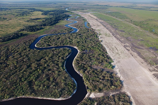
Image above: Through Kissemmee River Restoration water was routed back into a natural channel from straight drainage ditch it had been forced into improving Florida's ecosystem. From (https://www.tes.com/lessons/IO8d-fSGuKa1uA/ib-freshwater-part-3-river-floodplains-at-rhsb).

A few major themes popped up again and again. Connections between different areas let species move and migrate, which is crucial to resilience in many restoration efforts, including Florida’s Kissimmee River project. Habitat variability helps by making ecosystems more resilient to extreme climate events. A history of natural disturbance also can contribute to successful restoration.

The decision support table sorts resilience attributes into five categories based roughly on ecological scale: individual, population, community, ecosystem and process. Life span and reproductive strategy, for example, are individual attributes, while population density and genetic diversity are population attributes.

Ecosystem attributes include habitat area, habitat condition and connections between different habitats.

Each of the 45 attributes has two components: the project’s focus (whether it aims to restore a species, a habitat, or a whole system) and the project’s scale (whether it’s operating on one population, a single site, or an entire ecosystem).

Anyone who is interested can download and use the decision support table, which comes as an Excel spreadsheet (click the “S1 Table” link on the paper’s PLOS ONE page).

For guidance on a project, practitioners simply choose an appropriate focus and scale, then the table returns a list of attributes in the five categories that can best help build resilience under that project’s unique circumstances. Users are encouraged to provide feedback to the project team so the tool can be improved in the future.

“In the face of climate change,” the study notes, “restoration approaches that promote natural sources of resilience are more likely to be successful than those that focus on creating optimal steady states.”.

Saving the Colorado River Delta

SUBHEAD: Two Years After the Colorado Pulse Flow to restore the river delta — An abundance of life.

By Maureen Nandini Mitra on 21 October 2016 for Earth Island -
(http://www.earthisland.org/journal/index.php/elist/eListRead/two_years_after_the_colorado_pulse_flow_an_abundance_of_life/)


Image above: Martha Gómez Sapiens, a monitoring team member, stands on a riverbank next to willows and cottonwoods that germinated as result of the pulse flow. Photo by Karl W. Flessa. From original article.

Birds, plants, and groundwater continue to benefit from effort to revive the Colorado River delta.

Back 2014, an unprecedented transnational experiment attempted to restore, temporarily, the flow of the Colorado River to the Gulf of California. As part of a landmark agreement between the United States and Mexico, the International Boundary Water Commission unleashed an eight-week “pulse flow” of some 105,000 acre feet of water from a small dam on the US-Mexico border to help restore the Colorado River delta.

Conservationists hoped the water would revitalize the delta — which has been bone dry for nearly 60 years as a result of upstream dams and diversions on the Colorado — and bring back trees, animals, and aquatic life that were once abundant in the region when it was flush with water. (The transnational agreement authorized environmental flows of water into the Colorado River Delta from 2013 to 2017.)

Two growing seasons after that engineered release, it appears that birds, plants and groundwater in the delta, which lies south of the US-Mexico border, have indeed been benefitting from it.

Native willows and cottonwoods have sprung up wherever the pulse flow inundated bare soil and in response to this post-flood vegetation, birds have begun flocking to the area, according to the latest monitoring report prepared for the International Boundary and Water Commission by a bi-national University of Arizona-led team.

The interim report, released on Wednesday, documents the effects of the environmental flows in the delta from the initial pulse in March 2014 plus subsequent supplemental deliveries of water through December 2015.

"Some of the cottonwoods that germinated during the initial pulse flow are now more than 10 feet tall," Karl W. Flessa, UA professor of geosciences and co-chief scientist of the team that’s monitoring the impact of the pulse, said in a statement.

Migratory waterbirds, nesting waterbirds, and nesting riparian birds have all increased in abundance, the report says. The monitoring team found that the abundance of 19 bird species of conservation concern, including vermillion flycatchers, hooded orioles, and yellow-breasted chats, was 43 percent higher at the restoration sites than at other sites in the floodplain.


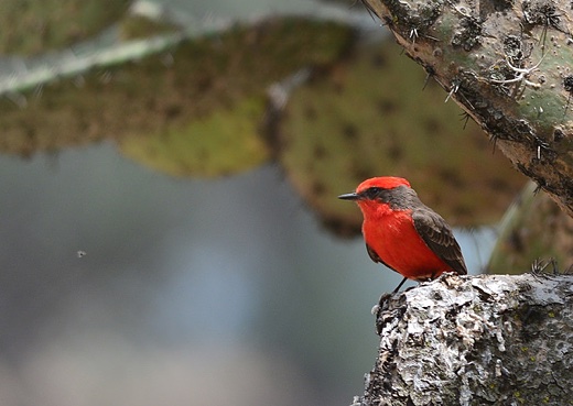
Image above: The abundance of 19 bird species of conservation concern, including vermillion flycatchers (pictured here), hooded orioles, and yellow-breasted chats, was 43 percent higher at the restoration sites than at other sites in the floodplain. Photo by Sarah Murry. From original article.

Some of the water from the pulse flow and subsequent smaller environmental flows recharged the groundwater, which had both ecological and social benefits, said Eloise Kendy, a senior freshwater scientist with The Nature Conservancy's North America Water Program who helped compile the report.

The vegetation greened up in areas that received surface water and also in some areas that did not. "The farmers [whose irrigation canals were used for some of the water deliveries] were happy because it recharged the aquifer they use for groundwater irrigation," she said. "And plants that were outside the inundation zone got a big drink of water.

Dams and river diversions built in the twentieth century have for decades prevented the river — that once flowed freely from the Rocky Mountains all the way to the Sea of Cortez in Mexico — from completing its journey to the sea.

These days it dies after it crosses the US-Mexico border. The southernmost dam on the river — Mexico’s Morelos Dam, near Yuma, AZ — diverts nearly all of the river water into an aqueduct that serves agriculture and homes in Tijuana. South of the dam, the river channel travels about 75 miles to the Gulf of California. With the exception of a few wet years, the river has not reached the Gulf of California since 1960.

Before 1960, spring snowmelts regularly sent water gushing down the Colorado River into the delta, scouring the river bottom and overtopping the bank and creating the ideal conditions cottonwood and willow trees to germinate and establish.

But since then, salt cedar or tamarisk, an invasive plant, has taken over the riverbanks. Since cottonwoods and willows need bare ground and sunlight to germinate, they cannot establish themselves on tamarisk-covered riverbanks.

The March 2014 pulse flow delivered a fraction of the water the pre-1960 spring floods used to bring to the delta. Staff from the Sonoran Institute and Pronatura Noroeste, a Mexican conservation group, cleared some areas of non-native vegetation beforehand. The researchers hoped that reducing competition would allow native plants such as willows and cottonwoods to germinate and grow after the pulse flow.

"We reconnected the meanders to the main river channels so when the pulse flow came there were these nice backwater areas where the conditions were good for the establishment of native trees," said Karen Schlatter, a restoration ecologist of the Sonoran Institute's Colorado River Delta Program, who was part of the monitoring team. In those restoration areas, cottonwood and willow seeds that germinated after the pulse flow have become 10 to 13 foot trees, and bird diversity and abundance has increased.

"Now we have diverse habitat types, including lagoons, cottonwoods-willow forest, mesquite bosque and marshes," Schlatter said. "We are seeing a much higher diversity of riparian bird species in the restoration sites compared to other areas along the river."

The pulse flow has also reduced soil salinity in some areas that had been targeted for restoration. "We didn't expect that — it is a huge bonus," Schlatter said. Reducing the soil salinity makes conditions more favorable for native plant species.  If there's another pulse flow, she suggests clearing tamarisk and other non-native vegetation from the river's bank ahead of it would be helpful.

The pulse was the only water release planned so far. Once this pilot project ends in 2018, US and Mexican officials will review findings and discuss whether other discharges should be made.

Part of the impetus for the pulse experiment was to determine whether a healthy delta system can be maintained without a lot of water. Of course, the delta can’t be restored to what it was a say, a century ago, given the cities and towns that need Colorado’s water aren't going anywhere, as well as the fact that much of the delta land has since been converted to farmland.

But, as Flessa says, this short-term experiment “really demonstrates that a little bit of water does a lot of environmental good."
.

Renewing Relatives

SUBHEAD: Indigenous people of Great Lakes restore nme` sturgeon species as key to environmental health.

By Holtgren, Ogren, Whyte on 13 November 2015 -
(http://www.earthisland.org/journal/index.php/eij/article/renewing_relatives)


Image above: Illustration of Nme` byYevgenia Nayberg. From original article.

For centuries, the ancestors of the Little River Band of Ottawa Indians, an Anishinaabe people of the Great Lakes region, gathered on the banks of the Big Manistee River every spring to celebrate the annual return of a revered fish to its age-old spawning grounds.

So ancient is this fish species, and so deeply intertwined is it with the tribe’s culture and survival, that the Anishinaabek sometimes call it the “grandfather fish.” But usually tribal members refer to the fish, which has been around since dinosaurs roamed the earth, as nmé. When the colonizers arrived, they renamed nmé “lake sturgeon.”

For many generations this massive, gray-white colored fish – which can reach up to six feet or more in length, weigh more than 150 pounds, and live up to 150 years – served the Anishinaabek as a substantial food source. “The grandfather fish would sacrifice itself so the people would have food [during the lean seasons] until the other crops were available,” says Jay Sam, the historic preservation officer of the Little River Band of Ottawa Indians, who live in what is now Michigan and within whose lands the Big Manistee River watershed lies.

Nmé populations in different parts of the rivers and streams also were aligned with clan-spirit and identity.

“There were different places on the river that were set for sturgeon clans,” says Jimmie Mitchell, the tribe’s director of natural resources.

Just as Anishinaabe families today are descendants of generations of Anishinaabek from this region, so too are surviving nmé today the descendants of those who interacted with the very same families generations ago. The fish was so important to the traditional culture that Anishinaabe leaders would sign documents with nmé images.

Before the colonizers arrived, nmé could be found in lakes and rivers all the way from Canada to Alabama, and were abundant in the basins of the Great Lakes, Hudson Bay, and Mississippi River. Regardless of this abundance, the Anishinaabek maintained a conservative approach to their harvesting practices, ever mindful that the balance of nature is in a constant state of change.

But that wasn’t the way of settlers, who initially killed nmé as a nuisance by-catch because the bottom-feeding (or benthic) sturgeon damaged their fishing gear.

Then, in the latter half of the nineteenth century, as lake sturgeon meat and eggs became prized, they trapped and killed nmé in even larger numbers. According to the US Fish and Wildlife Service, between 1879 and 1900 the Great Lakes commercial sturgeon-fishing fleet caught an average of 4 million pounds of fish per year.

This kind of overharvesting, along with other factors – such as clearcut logging practices, stocking rivers with nonnative fish species for sport fishing, environmental pollution, and dams that blocked nmé from returning to their natal streams and rivers to spawn – led to a drastic decline in nmé populations.

 By the early 2000s, only about 40 to 50 fish a year returned to spawn in the Big Manistee River and many historic nmé rivers lost their populations completely. Nmé came back to the river, not as a healthy component of either the river or tribal culture, but weakened, embattled, and imperiled.

Today, nmé are at less than 1 percent of their historic numbers and are listed as either threatened or endangered by 19 of the 20 states within their original range. In many ways, especially to settler Americans, nmé became a forgotten fish.

For the Anishinaabek, the nmé’s reduced runs meant the gradual erosion of a system of symbiotic living and the many traditions associated with it. “Decline of the sturgeon has corresponded with decline in sturgeon clan families,” says Kenny Pheasant, a culture carrier who teaches Anishinaabemowin, the language of the Anishinaabe, to people throughout the Great Lakes region. “Only a few sturgeon clan families are known around here.”

But there’s hope. During the past decade, a unique restoration effort by the Little River Band of Ottawa Indians has helped bolster nmé populations in the Big Manistee watershed, and revive their cultural and ecological connection to their nonhuman kin.

After the US reaffirmed its “recognition” of the Little River Band of Ottawa Indians as a sovereign nation in 1994, the tribe used its new government status to formalize natural resource stewardship and environmental protection programs.

Restoring relatives such as nmé is a central part of that.
Yet restoring nmé using the Indigenous conception of stewardship was not easy.

Some people in the Manistee area believed that tribal people did not desire to live sustainably. They believed that treaty rights were unfair to settler Americans.

The state of Michigan questioned tribal efforts for nmé restoration, claiming that the Little River Band of Ottawa Indians did not have the legal authority to engage in restoration work. Many local residents thought it was a waste of time and money to restore a fish that might take 100 years to recover fully.

In short, settler Americans did not understand Anishinaabe culture. They did not understand the Anishinaabe concept of sustainability, which is based on maintaining the relationships connecting humans, plants, animals, and the land. It’s a concept we call baamaadziwin, which in the Anishinaabemowin language means “living in a good and respectful way.”

Baamaadziwin, Mitchell explains, motivates people to go beyond being good and just “to being servants, devoting ourselves to making a difference in all that has occurred and may still be occurring within our respective communities and environment.” This, he says, “includes restoring the balance of our shared natural environment and of all inhabitants who are dependent upon a robust ecosystem.”

Despite the resistance from settler Americans, the tribe stubbornly persisted in its nmé restoration efforts, deeming it a sacred responsibility. The tribe was convinced that by reclaiming the nmé’s rightful place within the watershed, balance would be restored to the river’s other nonhuman kin. So tribal members and biologists crafted the “LRBOI Sturgeon Stewardship Plan.”

The plan envisioned a holistic management approach that would address the numerous threats to not only the watershed, but to the Great Lakes Basin as a whole. Although aimed at rehabilitating and reclaiming nmé, it also provided for the health and improvement of the animals, plants, and people living within the watershed.

The Sturgeon Program launched in 2001 and a year later the tribe successfully documented natural reproduction of lake sturgeon by capturing newly hatched nmé larvae (fry) from the Big Manistee River. In 2004, the Little River Band of Ottawa Indians established the first portable streamside rearing facility where young nmé collected from the river in spring were nurtured and protected until the fall, when they were released back into the same river.

This was the first time the technique had ever been used for lake sturgeon. Its success was especially important because this technique kept the fish “home” during rearing and because maintaining the genetic makeup of nmé populations in different rivers is crucial for the Anishinaabek, whose traditional beliefs include specific relationships between particular families and their local fish populations.

This idea also supports the principles of conservation biology, which seeks to maintain the unique genetic attributes of each river’s nmé population.

Since 2004, another five streamside facilities based on the same design have been set up within the Lake Michigan Basin. The tribe’s Nmé Stewardship Plan is now a guiding document for nmé restoration in the Great Lakes, and it has changed how the region’s fisheries are managed today. Many agencies, including the US Fish and Wildlife Service and the states of Michigan and Wisconsin, now collaborate with the tribe’s sturgeon program.

The success of the restoration program can be measured not only by the number of reared sturgeon in the Great Lakes, but in the changed the relationship between the settler Americans in the Manistee area and the Anishinaabek. Fishing guides, who previously were suspicious of the restoration initiatives, have begun voluntarily helping locate sturgeon.

Outfitters educate their clients about the importance of nmé and tribal stewardship. Settler Americans are now happy to see the tribal biologists on the river. The Little River Band of Ottawa Indians is no longer simply seen as a “casino tribe,” but as a nation doing distinctive work in the region based on Anishinaabe culture and science.

The watershed community now views nmé as a species whose presence makes the Manistee area special. The fish has been able to both heal old wounds and create new, sustainable, relationships among people, even in a watershed where these relationships have been strained by settler colonialism.

Now, every September hundreds of people – Native as well as settler – gather by the banks of the Big Manistee River to release young nmé into the waters with much fanfare, ceremony, and feasting. Each person cups a young sturgeon in his or her hand and gently guides it back to the river. A lasting connection is built between fish and human.

Most non-Natives present at the ceremony are probably not ready to adopt the Anishinaabe way of thinking about the world and our place in it. But in that moment of release they embrace a sense of themselves linked to a watershed shared with their nonhuman kin.

• Marty Holtgren and Stephanie Ogren are former staff of the Little River Band of Ottawa Indians. Kyle Whyte (Potawatomi) is a professor of environment philosophy and ethics at Michigan State University.


.

Argentina's plan to restore wetlands

SUBHEAD: The country is implementing an ambitious program to restore wildlife in its wetlands.

By Marina Aizen on 11 November 2015 for Huffington Post -
(http://www.huffingtonpost.com/entry/argentina-wetlands-wildlife_564219dde4b0307f2caf041c)


Image above: The Natural Ibera Reserve, home of a significant variety of fauna, is a natural paradise unique in its type. From original article.

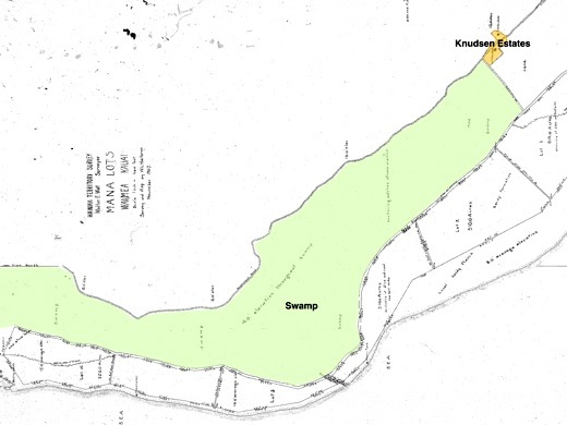
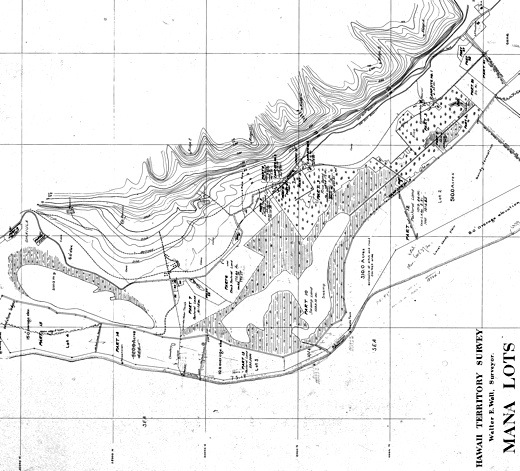
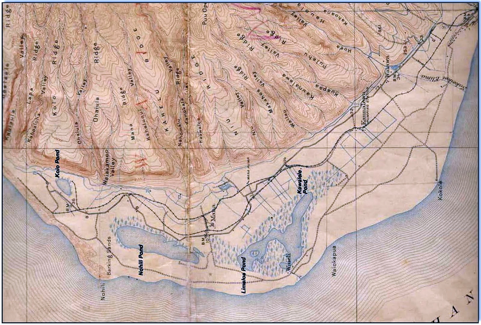
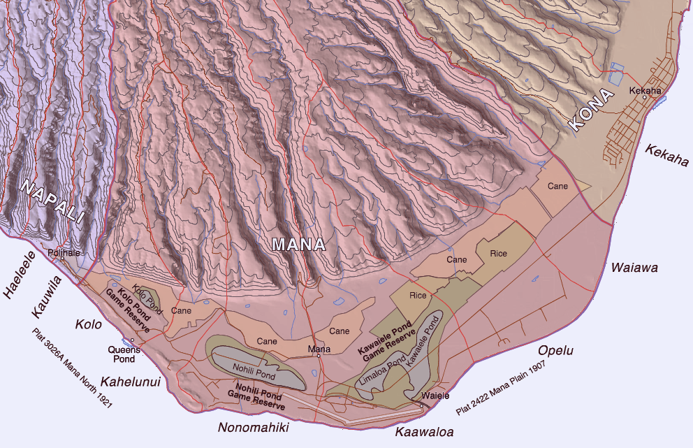
[IB Publisher's note: We published this to call attention to what could happen in Hawaii. The two greatest wetlands in Hawaii, Ewa on Oahu and Mana on Kauai, were both obliterated by American interests in the last century in a half. The Ewa plain was dug out for Pearl Harbor and the remaining Ewa plain has been burdened by military and industrial interests (now it is being scarred by the HART rail system construction). On Kauai the marshes of Mana were filled in for sugar cane and now are dominated by the military-industrial complex of the Pacific Missile Range Facility and the Chemical/Pesticide corporation's experimental GMO fields. For the long term health of the Hawaiian Islands we should restore the flora and fauna of these to sources of Pacific bird, insect, fish wildlife.]

The Ibera wetlands are witnessing South America’s largest experiment to reintroduce lost species, which will change the estuary’s appearance and dynamize its economy.

Tucked away in the shelter provided by the meadow, Jurumina is fast asleep, coiled like a fireman’s hose. Even her long anteater snout seems made for putting out fires. But nothing seems to disturb her in the Ibera, a landscape shaped by estuaries that this creature blends so well into.

Her natural connection to these bird-thronged surroundings is a picture postcard that, until recently, belonged to the realm of memory. For Jurumina’s species had been wiped out in this flood-prone land where camalotes bloom with purple flowers.

If Jurumina can now curl up to sleep and then get up to feed off termites scurrying nearby, it is because she is part of an ambitious experiment, the first of its kind in the Americas, organized by a team of Argentine and international scientists. They plan to bring together all the pieces of the jigsaw that the life of this vast wetland represents: it has been left damaged, fragmented and, in many cases, deliberately destroyed.

Only South Africa has carried out large scale reintroductions of animals. What is happening in the Ibera wetlands is setting a precedent in Argentina and many other countries. The technical term is ‘rewilding’.

Practically speaking, it means giving the environment back its original functions. In his San Alonso ranch, the biologist Ignacio Jiménez explains that you cannot divorce the landscape from its living inhabitants. And he claims that under the same bio-physical conditions – that is, the availability of water and the climate – an environment transforms according to the inhabitants that it supports.

In simple terms, the geography of a place will change according to whether or not it contains giraffes. And the landscape of the Ibera has been visibly impoverished by the absence of its charismatic critters.

Their return will generate more woodland and better meadows. Both have a key role because they sequester carbon from the atmosphere (the principal cause of climate change): one absorbs it, while the other fixes it in the soil and converts it into peat.

“Achieving a fully functional ecosystem means re-introducing large carnivores and herbivores. Rewilding says ‘let’s bring them back’,” Jiménez tells us. He works for the NGO Conservation Land Trust, established by US philanthropist Douglas Tompkins.

The project has a motto, “Corrientes vuelve a ser Corrientes” or, loosely translated, “Corrientes province is going back to how it was.” The province has been covered with posters featuring this slogan, because it is definitely society as a whole that will benefit from the restoration of its wildlife. The Ibera wetlands are today a mecca for eco-tourism because of its fabulous birds, capybaras, alligators and Cayará monkeys, among other animals.

“If we succeed here, in 30 years’ time this whole area will be full of life,” Jiménez says excitedly. “The Ibera will be home to woodland creatures that can serve as a tourist attraction. It is an historic opportunity to lessen a very real crisis. We have a trickle of species losses that we cannot make up for. Rewilding will generate better numbers.”

The sun has barely emerged from the horizon when a group of peasants comes into view, driving a JCB with an air of triumph. Their work is to continue the construction of gigantic pens that will shelter a new generation of jaguars until they can be released.

The pens of San Alonso, the most isolated point of the Ibera wetlands, have the look of a chemical molecule when seen from the air, with their four interconnected cages, each 120 square meters large. Inside live two females (the first to arrive is called Tobuna; she is magnificent) and two males.

Once the females are pregnant, they will be moved to bigger pens – around 1.5 hectares – where their young will be out of sight of humans. They will be left live prey so that they learn how to hunt.

Once they have reached maturity, they will be separated from their mothers and will go on to an even bigger pen, 30 hectares large. Everything works well in theory. “We still have to see if the reality corresponds to our ideas,” Jiménez admits.

One of the first species to return to the Ibera wetlands were the anteaters. They come from different areas, where many local people bring them up alongside their dogs. Girls find the baby anteaters affectionate and loving, but the critters stand no chance of surviving in a household environment.

“For this reason it is very important to work together with local communities,” says the biologist Alicia Delgado, head of the Rescue Centre in the Riachuelo area, where they undergo an obligatory quarantine before their relocation.

“The anteater is neither herbivore nor carnivore. It is an insectivore. It fulfills a specific role in the food chain, as insect eater and as prey to larger animals,” the scientist says.

The animal became extinct in the Ibera in the 1980s. Competition with dogs, hunting and habitat loss were the factors the sealed its fate.

See also:
Ea O Ka Aina: The Golden Plain  8/27/2013
Ea O Ka Aina: The Mana Mirage 4/17/1847
.

Beyond Resilience

SUBHEAD: As Climate Change creates "new normals" mitigation and adjustments will have to be made.

By Courtney White on 23 July 2015 for the Carbon Pilgrim -
(https://carbonpilgrim.wordpress.com/2015/07/14/beyond-resilience/)


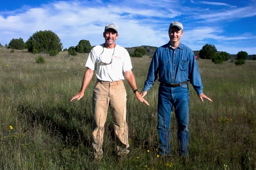
Image above: Photo of the abundant and diverse grasses that returned to the Cañon Bonita ranch. Mike Reardon on the left. From original article.

Restoring land to health means trying to return it to something like normal ecological conditions. But what if the definition of normal changes in the meantime?

An ecosystem’s capacity to absorb a shock, such as a drought, flood, or forest fire, and then bounce back as quickly as possible is called resilience. Since it’s a critical part of ecosystem health, ecologists have made a big effort to understand what constitutes “normal” conditions in order to help a system be as resilient as possible, especially if the shock has been caused by humans, such as overgrazing by cattle.

But what if a system’s definition of normal changes? What if a region’s annual precipitation dropped by half—and stayed there? Or when the rains did fall, they came as unusually large flood events or at the wrong time of year? What does resilience mean in this context?

It’s not an abstract question. Under climate change, scientists tell us, we’ll be experiencing all manner of new normals. For restoration purposes, this means we need to search the management toolbox for practices that go beyond short-term resilience and allow an ecosystem to endure long-term deviations from normal conditions.

What would those practices be? Mike Reardon has an idea.

Since the late 1990s, Reardon has used a wide variety of land restoration tools on his family’s 6500-acre Cañon Bonita Ranch, located in northeastern New Mexico. These tools include tree removal, brush clearing, prescribed fire, planned grazing, erosion control, riparian restoration, water harvesting, dam building, and ranch road repair—all in service of restoring ecological health to the land after decades of mismanagement by previous landowners.

Reardon’s overall goal is to support a multitude of diverse wildlife on the property and his work has been highly effective in this regard. Today, however, he faces a new challenge: How do you maintain forward progress when prolonged drought limits the use of certain tools?

In 1997, an expert with the USDA’s Natural Resources Conservation Service told Reardon that there were “too many trees” on his ranch. This was news to Reardon, who lives in Albuquerque and readily admits to being a novice about land health when he began managing the ranch. Too many piñon and juniper trees, the expert said, meant a reduced amount of open, grassy habitat for wildlife. In the past, nature corrected this situation with periodic, lightning-sparked wildfires that would thin out the trees, allowing the land to bounce back with perennial grasses.

However, a century of fire suppression by landowners and cooperating agencies across the region, coupled with poor livestock management, eventually eliminated the land’s grass cover, resulting in widespread tree encroachment.

To reverse this situation, Reardon focused first on reducing the density of piñon and juniper trees on the ranch. His original tools were handheld loppers and a chainsaw. Then came a spin trimmer, a front-end loader, and a Bobcat skid-steer. Next, Reardon hired a professional woodcutting crew from Mexico. To date, nearly three thousand acres have been cleared on the ranch, though some stands of trees were left for wildlife.

Next, during the years when grass (and rain) was abundant, Reardon alternated the use of two other tools to further reinvigorate the grasslands: prescribed fire and planned grazing. With the assistance of neighbors and fire experts, Reardon has completed two controlled burns, ten years apart, which effectively suppressed tree seedlings.

Reardon also employed the tool of high-density, short-duration grazing by cattle during the vegetative dormant season (December through March). This “living fire” recycles old grass into cattle manure, which helps to build grass cover.

All three tools worked. Grass came back with a flourish, teaching Reardon an important lesson.
“I learned that bare ground was enemy number one,” Reardon said, “so I do everything I can to get grass to grow. And not just any grass, I want perennials and I want as much diversity as possible.”

The next job for the resilience toolbox was water. In order to create more surface water for wildlife to drink, as well as grow a year-round supply of nutritious food, twelve earthen dams and four metal tanks (with windmills) were repaired, modified, or constructed across the ranch. He also implemented a five-phase wetland and riparian restoration project that employed many of the innovative practices pioneered by specialists Bill Zeedyk and Craig Sponholtz.

They designed and implemented treatments for a two-mile stretch of Cañon Bonito Creek, which ran through the center of the ranch. Their goals were to decrease stream bank erosion and downcutting and to raise the water table. They also wanted to reconnect the creek to its floodplain in order to re-wet adjoining wet meadows and increase the amount of live water.

They also hoped to increase forage species, including wetland vegetation, and increase cover for wildlife. There was even a plan to harvest water from ranch roads using a variety of techniques, including redesigned road crossings and water-harvesting rock structures in canyon side channels.

Reardon also implemented a detailed monitoring program on the ranch in order to see how changes were progressing. This included vegetation and bare-ground monitoring, moisture data collection, wildlife population surveys, and photographic documentation, including sixty photo points along Cañon Bonito creek alone.

The message of the monitoring data was clear: conditions were improving. Under Reardon’s management, the ranch progressed from a monoculture of blue grama grass to hosting a diversity of more than 55 different grass species. Dry springs began to flow again and wildlife populations shot up by a factor of ten.

Despite a drying trend that began in 2002, deer, elk, and wild turkey populations continued to rise and things seemed to be returning to normal. It looked like Reardon had succeeded in rebuilding resilience on the ranch.

Except the definition of normal was changing. The drought, for example, went on and on—and still goes on.

Today, year-round water in the Cañon Bonito creek is rare, though there is still a steady trickle in the spring area. A relict population of ponderosa pines is dying, along with piñon and juniper trees. Small populations of perennial grasses, previously restored, are now dying as well. And wildlife populations are in decline—wild turkey populations have dropped by 75 percent. As for the land management toolbox—persistent drought means that prescribed fire is off the table and grazing by cattle is limited to selected areas of the ranch.

Reardon has learned the hard way that getting “beyond resilience” is easier said than done.
On the good news front, there is still plenty of ground cover holding the soil in place, capturing “airmail topsoil,” as Reardon puts it, during local dust storms, as well as any raindrop that falls from the sky.

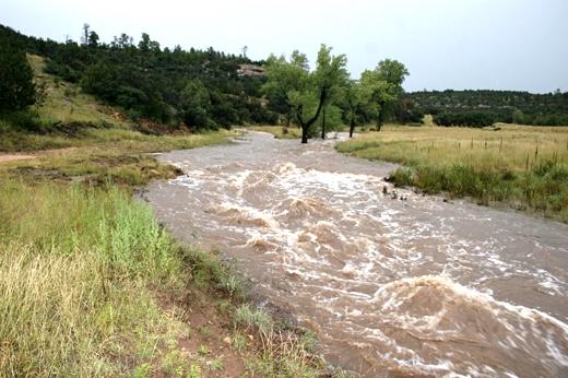
The wetland and riparian restoration work have kept the ground moist where otherwise it might have gone dry. It also helps to dissipate the destructive forces of unusually big flood events, such as one the ranch endured on September 2013, when nearly five inches fell in a matter of hours. Thanks to all the vegetation that had grown along the stream banks, the effects of that flood were not nearly as devastating as they would have been otherwise.


Image above: Here’s a photo of the new normal of big flood events on the ranch. From original article.

For Reardon, the whole experience points to important lessons learned for the new normals of hotter, drier conditions and chaotic moisture events.

“Use your time effectively,” he said, “focus on sweet spots, have a plan, pull together a diverse group of supporters and professionals, be willing to listen and learn, trust the data, be willing to admit mistakes, be proactive, become land literate, and get ready for the next storm—dust, rain, snow, whatever Mother Nature brings. It will rain again!”

Sage words as we move deeper into the twenty-first century!

• Courtney White is a former archaeologist and Sierra Club activist, Courtney dropped out of the 'conflict industry' in 1997 to co-found The Quivira Coalition, a nonprofit dedicated to building bridges between ranchers, conservationists, public land managers, scientists and others around the idea of land health. This is a chapter from his forthcoming book 2% Solutions for the Planet to be published by Chelsea Green in October. See: http://www.chelseagreen.com/two-percent-solutions-for-the-planet]


.

BP Gulf Spill Ignored

SUBHEAD: Five years after the BP oil disaster a barrier island for nesting birds is still devoid of life.

By Julie Dermansky 19 April 2015 for DeSmogBlog -
(http://www.desmogblog.com/2015/04/19/five-years-after-bp-oil-disaster-barrier-island-nesting-birds-devoid-life)


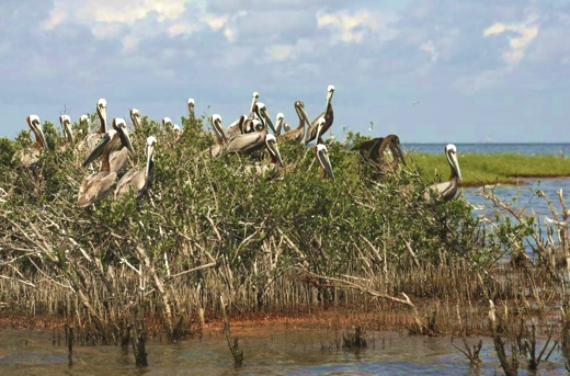
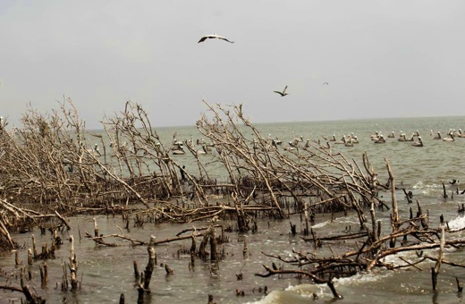
Image above: Cat Island, Mississippi, on May 22, 2010, nesting pelicans are seen as oil washes ashore from BP Deepwater Horizon oil spill. From (http://www.spokesman.com/picture-stories/gulf-oil-spill-one-year-later/#867).

Cat Island, off the Gulf Coast in Louisiana's Plaquemines Parish, was home to a vibrant bird rookery inhabited by brown pelicans, seagulls, spoonbills, and egrets before BP's Deepwater Horizon oil disaster. Five years after the largest oil spill in American history, the barrier island has just about disappeared.

Despite ongoing efforts by former Plaquemines Parish coastal zone manager PJ Hahn to restore the island, only the needed building permits and an engineering plan have been completed.
"Cat Island was ground zero of the oil spill," Hahn told DeSmogBlog.

He thought that the restoration of the island was a no-brainer since, while much of the oil spill's damage was underwater and invisible, the damage to Cat Island was easy to prove. According to Hahn, not only would the island's restoration be necessary for the birds, but it would provide a great public relations move for anyone who helped in the process.

At the time of the spill, Cat Island was approximately five and a half acres, covered by a dense forest of black mangrove trees which were occupied by nesting birds. All that remains now are two small strips of land — less than an acre combined. Mangrove stumps jut out from the broken, shell-covered sandy remains of the island, at times fully submerged during high tide.

"The island was a treasure and it deserves to be restored," Hahn told DeSmogBlog. He continues to advocate for the restoration project he spearheaded.

"It's a hard sell for many since the island doesn't serve as storm protection like other barrier islands that are in the process of being restored since the spill," Hahn said.

But Cat Island and other small barrier islands, some of which have completely eroded since the spill, were perfect bird habitats because they were free of predators. Hahn believes the $6 million restoration price tag is a good investment, one that will pay for itself in dollars generated by the tourism industry. "Bird watchers from all over will come to visit the island," he said.

So far, the parish has raised $3 million of the $6 million needed before the rebuilding process can begin.
Shell, the only oil company to contribute, donated $1 million. Other contributors include the American Bird Conservancy and the federal Coastal Impact Assistance Program. The parish hopes to get the rest of the needed funds from the state's "Restore Act Fund," made up of money from that part of the BP settlement that has already been paid.

Billy Nungesser, Plaquemines Parish president during the spill who is now running for lieutenant governor, had been famous for his fierce criticism of BP. But now it seems he's changed his tune.

During a town hall meeting hosted by Rush Radio in St. Tammany Parish, where residents turned out to express their concerns about the possibility of the first fracking project in their area, Nungesser gushed over the great relationship Plaquemines Parish has with the oil industry, no longer singling out BP as a bad player as he had in the past.

Though he believes residents should have a say regarding what type of industry is welcomed in their community, he said oil companies that operate in his parish "do the right thing."

Referencing the "horrible pictures of the pelicans covered in oil," Nungesser claimed that in the case of "a safety incident or something spilling from a platform, every company has gone beyond the call of duty in our parish to make it right. Oil companies are rebuilding those islands."

But Cat Island is a perfect example that Plaquemines Parish "has not been made whole," according to Hahn. "BP was asked to contribute to rebuilding Cat Island multiple times," Hahn said, "but they haven't given anything to help the project."


Image above: Cat Island on April 8, 2011 photo, dead mangrove is seen on an eroding point of Cat Island, heavily damaged by oil from the BP oil spill. The island remains unrestored. From ((http://www.spokesman.com/picture-stories/gulf-oil-spill-one-year-later/#867).).

Cat Island was not mentioned in a BP report on the condition of the Gulf issued in March which paints a picture of the Gulf Coast on the mend. According to the report, "Available data does not indicate the spill caused any significant long-term population-level impact to species in the Gulf," and "affected areas are recovering faster than predicted."

State and federal agencies involved in the Natural Resources Damage Assessment (NRDA) took issue with BP's report.

"It is inappropriate as well as premature for BP to reach conclusions about impacts from the spill before the completion of the assessment," an NRDA report states. NRDA will determine how much BP and its subcontractors owe for the environmental damages.

When asked what specifically BP has done to restore Cat Island, BP media spokesperson Jason Ryan sent out a statement about other coastal restoration projects the company has contributed to.  

BP agreed to pay for restoration projects in advance of NRDA's assessment, which it was not required to do. Several of the projects are underway, but rebuilding Cat Island is not one of them.

The statement from BP points out: "The state loses about a football field worth of wetlands every hour," and that "with regard to Cat Island specifically, it was rapidly eroding before the spill, primarily due to the impacts of Hurricanes Katrina and Rita."

Though BP wouldn't give a "Yes" or " No" as to whether it has contributed to rebuilding Cat Island, the company wrote: "We are studying shoreline erosion on marshes and barrier islands, including Cat Island, to determine if there was any acceleration due to the spill."

The BP spill "totally accelerated" the erosion of Cat Island," Linda Hooper Bui, an entomologist at Louisiana State University, told DeSmogBlog.

Bui has been working on studies of insect life in Barataria Bay that she began prior to the BP oil spill, making her a witness to the ongoing erosion process impacting the island. When plants are stressed they can't hold on to sediment, she explained. And that is what happened when the oil covered the plant life on Cat Island. "You lose the mangrove, you lose the sediment," Bui said.

"Heavily-oiled marshes erode at double the rate of a non-oiled marsh," Melanie Driscoll, Director of Bird Conservation for the Gulf of Mexico and Mississippi flyway for the Audubon Society, told DeSmogBlog, citing a scientific peer-reviewed study done after the BP spill.

"Every year there is a delay restoring the island, there is less area for nesting," Driscoll said. " We need restoration to proceed as soon as possible."

On March 31, a trip arranged by Restore the Mississippi River Delta Coalition gave members of the media a chance to document what little remains of Cat Island. The National Wildlife Federation, a key player in the coalition, released a report about the health of the Gulf five years after the spill that paints a completely different picture than BP's.

The NWF report cites several scientific studies that document the negative impact the spill had on 20 different species, including the brown pelican, which were Cat Island's main inhabitants.

"The tragedy is brown pelicans were taken off the endangered species list the year before the spill," Hahn said. "If there is no habitat, there are no birds. Who knows if they will come back when we finally get the island rebuilt?"


.

The Colorado River Delta

SUBHEAD: Scientists plan for grand experiment in the Colorado River Delta - Some rewatering.

By Sandra Postel on 12 December 2013 for National Geographic -
(http://newswatch.nationalgeographic.com/2013/12/12/scientists-plan-for-grand-experiment-in-the-colorado-river-delta/)


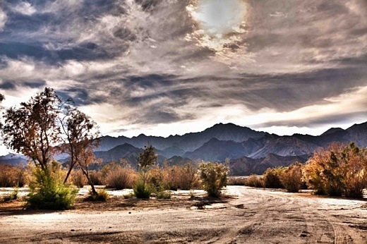
Image above: The dry Colorado River Delta against the Cucapá Mountains. Photo by Erik Rochner from original article.

Once written off as dying of thirst and beyond revival, the delta of the Colorado River is slated to get a rejuvenating flood that for scientists offers a unique opportunity: the chance to study how plants, trees, birds, fisheries, and the vast delta ecosystem as a whole respond to an experimental pulse of river water.

This flood is made possible by Minute 319, the add-on to the 1944 treaty between the United States and Mexico that divides the Colorado River between the two neighboring nations.

Signed in late 2012, Minute 319 allows Mexico to store some water in Lake Mead, the giant reservoir behind Hoover Dam, establishes new rules for sharing shortages in times of drought, and commits the two nations to return some flow to the delta as part of a five-year pilot project.

The Colorado Delta was once one of the planet’s great desert aquatic ecosystems, boasting 2 million acres of lush wetland habitat. For millions of years, it received a huge spring flood as the winter snows melted in the Rocky Mountains and the resulting flows coursed south. The flood waters spread across the delta before emptying into the upper Gulf of California.

That yearly flood cleansed the river channel and floodplain, recharged groundwater, aided the reproduction of native cottonwoods and willows, and sustained the overall delta ecosystem and its extraordinary bird and wildlife habitat. It also connected the Colorado River to the sea, where fisheries depend on the mixing of saltwater with fresh water for their spawning and rearing grounds.

But the construction of big dams and river diversions during the 20th century siphoned off the river’s flow, leaving little or none for the delta in most years of the last half century. Wetlands have shrunk to about 10 percent of their former area, and fish, birds and wildlife have declined dramatically. The native Cucapá, who fished and farmed in the delta for at least a thousand years, have lost their way of life.

The last time the delta enjoyed a significant influx of fresh water was in the late 1990s, a period of unusually high precipitation in the Colorado watershed that resulted in “surplus” water passing through the basin’s dams, across the international border, and on to the thirsty delta in northwestern Mexico.

Writing in this week’s issue of Eos, a publication of the American Geophysical Union, seven scientists who have collectively clocked decades of research in the Colorado Delta note that those 1990s flood pulses “demonstrated the resilience of the riparian zone and gave hope for its potential restoration, should a regular supply of water be found.”

Minute 319 calls for a flood pulse of 105,392 acre-feet (130 million cubic meters). The water will be released from Lake Mead at Hoover Dam, and then, mimicking the historic natural flood, will flow south to the delta.

Compared with the pre-dam spring flood of some 15 million acre-feet, this pulse appears paltry. But the delta scientists expect it to be sufficient to flood low terraces and backwaters, move channel sediments, recharge groundwater, and promote the germination of native cottonwoods and willows, which create prime habitat for birds.

Last February, a National Geographic team and I traversed parts of the delta with Osvel Hinojosa Huerta, an ecologist with the Mexican conservation organization ProNatura Noroeste and a co-author of the Eos article.

We visited a local nursery that was growing young cottonwoods, willows and mesquite, native trees that are being planted along the river channel and in wetland restoration sites. The anticipated spring flood will help them get established and reproduce.

Teams of scientists from both sides of the border are collecting pre-flood baseline data and, after the flood, they will track the immediate and longer-term effects on the delta’s vegetation, birds, wildlife, and other ecosystem attributes.

The hope is that beneficial results, and the potential for more, will lead the two countries to expand the restoration effort beyond this pilot period and establish a longer-term commitment to revitalizing the delta.

The experimental spring flood offers a rare scientific opportunity, to be sure.

But even more important, it is a crucial step toward restoring a great aquatic ecosystem, and shows the power of political and scientific cooperation in solving our water problems.

To learn more, click here to see our National Geographic videos, blog posts and photo galleries of the Colorado Delta.

• Sandra Postel is director of the Global Water Policy Project, Freshwater Fellow of the National Geographic Society, and author of several books and numerous articles on global water issues.  She is co-creator of Change the Course, the national freshwater conservation and restoration campaign being piloted in the Colorado River Basin.

.

The Second Genesis

SUBHEAD: Sowing seeds in the desert, natural farming, global restoration, and ultimate food security. 

By Erik Curren on 18 September 2013 for transition Voice -
(http://transitionvoice.com/2013/09/deserts-non-native-species-and-the-second-genesis/)


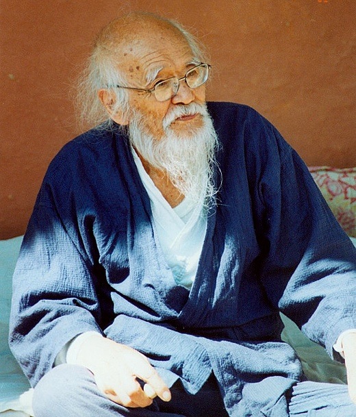
Image above: Masanobu Fukuoka contemplates before throwing one of his seedballs in Navdanya, India. From (http://www.flickr.com/photos/25788156@N06/2500691769/).


When Zen farmer Masanobu Fukuoka proposed that military bombers of his native Japan be used to drop balls made of seeds for hundreds of plant species over the world’s desert areas in order to revegetate them, housewives and children around the country started sending Fukuoka donations of seeds.

Though his dream of a vegetation air force has yet to become a reality, Fukuoka’s book Sowing Seeds in the Desert: Natural Farming, Global Restoration, and Ultimate Food Security tells the story of how he did work with authorities in India and Africa to successfully start growing plants in deserts and bring back forest habitat for elephants and people.

And Fukuoka claims that his method can help regenerate other degraded areas too, replacing extinct species around the world with new ones and leading to a Second Genesis. But his work has implications far beyond farming and land, offering a way to deal with such huge issues climate change, peak oil and economic collapse.

A quiet revolutionary
For more than half a century, Fukuoka ran a farm where he grew rice organically without plowing or flooding his fields as Asian farmers have done for centuries. Yet, his more natural method produced double the yield.

In 1975, Fukuoka published an autobiography dealing with his farming techniques and his Buddhist-friendly philosophy, The One-Straw Revolution. When the book was translated into a couple dozen languages Fukuoka gained recognition as a leader in sustainable agriculture. He continued farming until he died in 2008 at age 95.

In Sowing Seeds in the Desert, edited after the author’s death by American disciple Larry Korn, Fukuoka extends his method to the desert areas of the world, now poised to spread at an accelerating rate due to droughts caused by climate change.

Unlike traditional approaches like drilling wells or damming rivers to provide irrigation that exhaust precious water resources for little long-term benefit, Fukuoka’s angle is just to dump a bunch of seeds on a dry area and see what takes, without the need for any artificial irrigation.

Fukuoka jokes that this his method is a lazy one. But letting nature take charge may be more effective than trying to exert more human control.

Most of the seeds will fail to sprout. But those that do take root have a better chance to thrive in that environment. And if they do thrive, they will start a virtuous cycle of growth of grasses and moisture retention that will bring water back to a dry area naturally. This sets the stage for bushes and trees and eventually, return of a robust forest.

Not going native
Forget about restoring native species, Fukuoka counsels. On degraded land, those are the very species that disappeared in the first place, so they probably won’t work any better now.

“We cannot simply put things back the way they once were,” he writes. “Too much has happened. Conditions are far different today from what they were just one hundred years ago…Even if we did go to the trouble of putting back the plants that were once native to a certain place, there is no guarantee that they would thrive there anymore.” Instead, he urges us to just jumble plants up and let nature sort them out:
My idea is entirely different. I think we should mix all the species together and scatter them worldwide, completing doing away with their uneven distribution. This would give nature a full palette to work with as it establishes a new balance given the current conditions. I call this the Second Genesis.
This is an intriguing enough idea to deal with the spreading deserts of the Sahel, the Middle East or Northern India. But Fukuoka says that much of Europe and North America (including about half of the U.S.) are just deserts waiting to happen, with a surface layer of green grass and trees hiding dangerously degraded soil that gets worse every decade.

A lesson for localizers
Sowing Seeds in the Desert is a thought-provoking and inspiring book with implications beyond restoring deserts or making organic agriculture more effective.

Mixing plants from all over the world can serve as a metaphor for a new kind of culture that’s both local and global, a cosmopolitan-local society that would mix ideas and traditions from all over the world and then see which combination works for people in any particular place.

For example, if you live in Mississippi, it’s OK to choose Zen meditation and green tea over Southern Baptism and football at Ole Miss. Likewise, living in rural Japan shouldn’t stop you from playing the Gulf Coast blues on your banjo from Biloxi.

Fukuoka would surely tell regionalists everywhere that you shouldn’t feel guilty for being inauthentic or ignoring local culture if you try something from across the globe. And only by using the best approaches from around the world can communities adapt successfully to climate change, peak oil and economic collapse.

The inclusion of Fukuoka’s own amiable brush paintings adds a meditative element that makes reading Sowing Seeds in the Desert even more delightful.


Video above: Masanobu Fukuoka rice and orchard techniques. From (http://youtu.be/sQOG-dBsgzQ).

Click here for Masanobu Fukuoka's book "Sewing Seeds in the Desert"


.

The Golden Plain

SUBHEAD: Mana was once a vital wetlands supporting the lives of fish bird and plants - It can be again.

By Juan Wilson on 27 August 2013 for Island Breath -
(http://islandbreath.blogspot.com/2013/08/the-golden-plain.html)


Image above: Vernal ponds on the westside. In this case Puolo Point, near Hanapepe. Photo by Juan Wilson.

An imaginary true story
Imagine you are in Kekaha, Kauai, during a full moon near the Winter Solstice early in the 20th century; or more precisely at sunset on December 19th in 1907. As the sun is setting you are at the western end of Kekaha in a grove of palm trees at the sandy southern edge of a wetland. It is a place the Hawaiians call Pokii.

The bright day is cooling as above you the glow of as the sky turns from orange to a deep purple.  You look down again you see a small outrigger canoe slipping across the shallow water. It will soon take you north.

Your guide uses his paddle to pole you into the marshy water as the canoe rocks. It has rained a lot above the Mana plain in the last week and the water has made its way to down to the marsh. After a short while you are gliding through the water in an area fringed with sedge grasses. On either side, beyond the marsh, flooded fields of rice reflect what is left of the twilight.

To your left a thick forest of kiawe borders the marshland. You can barely hear the winter swell crashing on the shore break beyond the trees. A Pueo owl hovers over a clearing in the trees as it hunts for dinner.

On the right are the quarter-mile high cliffs of Mana and above them the grassland on the mantle above. The grassy mantle is divided by forested narrow valleys that cut the land into what look like loaves of bread set side by side. You can see farther when open water widens into the lower part of the 500 or so acres of Kawaiele Pond.

From the valleys along the base of the cliffs a forest of lehua and ohia trees spills. The valleys carry the fast moving rainwater from far above down to the Mana Plain. There along the base of the cliffs the marsh edge is fringed in pili and makaloa grasses.

As the dusk becomes darkness your guide points ahead. The moon is shining brightly on the smooth water. Suddenly there is a flash as a school of young fish leaps through the water and into the air chased by something unseen.

There is a great variety of fish, birds and plants that depend on this expansive wetland for their birth and sustenance. How many we will never know.

The rice paddies are behind you now. You are lucky to have this guide through Kawaiele Pond as it has branches that sprawl in different directions. One way leads to an outlet to the ocean and the village of Waiele in Kaawaloa ahupuaa.  There are stone walls lining fishponds near the shore of the village. Here fish enter to spawn in the Mana wetlands. The keike thrive in the warm brackish waters until it's their time.

In the distance there is a flatboat with two of men in it. One holds an oil lamp over the water while another gathers something from the water with a net. Shorebirds used these marshes to breed and hunt the fish too.

You pass through another branch of the pond leading to Limaloa Pond and Hohili beyond. You turn to look behind at the moon. The sky is cloudless. The moon is so bright that at first you do not see the rainbow surrounding it. As your eyes adjust the colors around the moon seem to pulse.

The guide has reached the northern end of Limaloa Pond and he nudges the bow of the canoe into a reedy area that seems solid enough. Above and ahead of you a line of clouds moves slowly with the trades strung down Mana Ridge from the swamp and forests of Kokee. It streches across the channel to Niihau bringing fresh water with it. After a short portage over a sandy area the two of you slip the canoe into the marsh of Nohili Pond in Nonomahiki ahupuaa. The guide navigates the canoe through the grassy area and into open water.

This is not as big as Kawaiele or Limaloa Pond but it has an impressive feature ahead to your left - it glows white in the moonlight with a scattering of dark tree stands on its back - its known to many as Barking Sands. At the peak the sand dunes of Nohili Point are about 100 feat high - the tallest in Hawaii. The beach they sit on is the longest in Hawaii as well, stretching over ten miles uninterrupted from Kekaha to Polihale.

You are tempted to end your trip at south end of Barking Sands. It is certainly about the most spectacular place to survey Mana and the ocean, but you have another goal farther ahead. The northern marshes of Nohili Pond are just ahead. As you drift onto shore you hear the scrape of sand on the canoe's hull. 

Once you land you could stay with your guide and go over the next portage and soon reach Kolo Pond close to the cliffs. It is a special place, but your plan is to head toward the old road that skirts the back of the dunes and reach Queen's Pond that lies along the shore of Kolo Ahupuaa. It is not a long walk.

You walk along the old dirt road and in s short while you cross into Kahelunui ahupuaa. The giant sand dunes north of Barking Sands continue there march up the beach with you. Kahelunui is narrow so its not long before you enter into Kolo ahupuaa; not where the pond is back at the cliff, but near the ocean dunes.

The old road passes through a group of giant monkeypod trees  Their ancient boughs make semicircular arcs from the massive trunks almost reaching the ground. The trees are the marker to head towards the ocean and Queen's Pond. You hike up the sandy path through kiawe trees that provide the only shade available in the day.  The moon is casting its shadows of the treetops in the white sand. You are careful to avoid the thorns of their fallen branches.

The dunes here are high and block the sound of the ocean. However you do hear laughter from the top of the 50 foot dune. The path ramps up to a clearing and you see sparks fly into the sky. You have found your friend's campfire in the dunes protected from the ocean wind. After a brief greeting you're off down the face of the dune heading toward to the ocean and the pond.

Queen's Pond is fully formed next to the ocean, and glistening in the moonlight. Tonight the pond is fat. It lies parallel to the ocean over 700 long by 150 wide. It is probably over your head in the middle.

Being a tidal ocean pond it forms in the sand only under the right conditions. It can disappear in a matter of hours or stay on for weeks. You never quite know if it will be there the next time you come. No one is out here but you and your friends.

You strip off your dusty clothes and touch a toe in the pond. The pond has been in place for couple of sunny weeks so it is warm. You wade in on the sandy bottom. There is a greenish blue flash beneath you. Your feet must have disturbed some bioluminescent algae growing in the pond.

Surprised, you laugh. A friend dives in head first and waves of aqua color light radiate out in front of her. You can see tiny fish dart away as you decide to dive in too - eyes open you see more rainbows.


Image above: Looking north towards Queens Pond and Polihale in distance, from the border of Kolo Ahupuaa, Photo by Juan Wilson.

The reality of it all
In 2010 I was asked to map the traditional land areas of the islands of Hawaii. They consist of the moku (roughly bioregions) and ahupuaa (roughly watersheds) of each island.

The indigenous Hawaiians developed a land management system utilizing the moku and ahupuaa to achieve long lasting agricultural and aquaculture practices. Although it was not perfect, it supported people's needs while protecting the environment for a longer time than modern practice has proven to do.

The Hawaiian success, as with most cultures, resulted in higher populations. Pigs escaped domestication and tore up the mountains. Birds became extinct because of the color of their feathers. Limits of acreage in the valleys meant greater difficulty expanding food production. These factors and more meant leaning too hard on the resources of the land.

As Hawaiian population reached into the hundreds of thousands, stricter regulation and control (kapu or taboo) of people increased. These disciplines were needed to maintain a precarious equilibrium with the environment. Even with these difficulties the pre-contact Hawaiians did better protecting the land than those from afar who settled here. By the time of Captain Cook's landing on Kauai, in 1779, growing population was something that Hawaiians already were dealing with. But not for long.

After taking just about every whale in the Atlantic the whalers moved to the Pacific with the attendant missionaries. They brought new diseases that decimated the Hawaiian people. As much damage as they did to Hawaii was only topped by plantations and the military.
Plantations:
The industrialized agriculture (primarily sugarcane and pineapple) that began in the 19th century that was practiced by Americans and Europeans required terraforming the islands to divert water our of the valleys and swamps and to where large fields could be assembled for irrigation of monocultures. The Hawaiians who depended on the natural flow of water in their valley watersheds were not consulted. The practice of Hawaiian culture shriveled. many of those Hawaiians who survived intermarried with imported plantation laborers and they and their progeny ended up in work camps no longer managing their own valleys.

Military:
The US Navy realized quickly that basing a fleet in the Pacific Ocean was a strategic necessity. By 1887 the Navy had exclusive rights on Oahu to repair and fuel ships in the shallow bay that was part of the largest wetland in Hawaii (now Pearl Harbor). Just a few years later a conspiracy between the plantation owners and US military overthrew Hawaiian sovereignty. Pearl Harbor was needed to take down Spanish Imperialism in the Pacific and replace it with an American brand. Pearl Harbor was dredged out and bulkheaded. Docks were built and bilge was jettisoned. What had been a shallow wetlands and marsh rich in plant and wildlife became a machine for the US Navy... which is the single most destructive organization on the planet.
Here on the outer island of Kauai we certainly were not immune to the effects of plantations. In fact, it was the observations by missionaries of the rich and productive Koloa Field System of the Hawaiians that inspired the first sugarcane plantation.

The Hawaiians had diverted the fast flowing Waikomo stream and other southside fresh water systems into a sophisticated irrigation system of ditches, loi and fishponds that produced vast amounts of food to support a large population. The Koloa Field system was so productive that it exported yams and sweet potatoes from Koloa Landing to California, to field hungry Forty-Niners during the California Gold Rush. The Hawaiians also had been growing sugarcane for their own use.

By 1835 Ladd & Company had started the first commercially successful industrial sugarcane plantation. Others soon followed. Ditches were dug, reservoirs were built, fields were irrigated.

On the west side of Kauai was the largest level area of land in Hawaii and the second largest wetland after Pearl Harbor. Chris Cook, former editor of the Garden Island News wrote in an article in 11/27/2000:
...the land (of Mana) was populated by Native Hawaiians who landed canoes at Pokii near Kekaha, which was then but a village marked by a stand of palm trees. Other villages dotted the base of the cliffs that reach sea level at the base of the once marshy Mana Plain, and Lehua forests grew down to the bottom of the cliffs.
The plain would flood following heavy rains, allowing outrigger canoe paddlers to travel freely from Mana to Waimea. Some taro planters there grew their crop atop unique wooden rafts that could rise and drop with the floodwaters...
Vladamar Knudsen began operating the Kekaha Sugar Company mill and plantation in 1856. Knudsen drained about 50 acres of the marsh along the Mana Plain and planted the first crop of commercially grown sugarcane there in 1878.

By the beginning of the 20th century Knudsen and family with the help of Hans Faye had plans for the Kekaha Ditch and the Kokee Ditch, which together diverted the water of the Waimea River and the Alakai Swamp into ditches feeding the upper reaches of Mana Moku near Puu Opae, and the lower flatland of the Mana Plain. Together these fields were the highest and lowest altitude sugarcane fields in operation.

Mana in 1907
In November 1907 a map of the Mana Plain was drawn up using the framework of the US Geological Surveys we still see today. The map appears to be a preliminary map prepared to be part of the Hawaii Territorial Survey under the authority of Walter E. Wall, Surveyor. The map was created by W. L. Heilbron.


Image above: A preliminary plan of Palt #2422 of Mana was done in November 1907 for Walter E. Wall, surveyor. Click to enlarge. Note we have highlighted swamp in green and Knudsen Estates in yellow.

This preliminary map shows two roads from Kekaha out towards Polihale. One was Government Road along the base of the Mana Cliffs and the other was a road behind the dunes and kiawe forests. Heilbron noted the area with the simple word "Swamp" and noted "4.0' elevation throughout Swamp" above sea level. Only to the southeast extreme, in front of the estates of Augustus and Eric Knudsen, was "Cane" identified.


Image above: Hawaiian Territorial Survey Plat #2422 of Mana in December 1907 for Walter E. Wall, surveyor. Click to enlarge.

Only a month later, in December 1907, another map drawn by Heilbron. It the official HTS Plat Registered Map 2422. It shows much greater detail than the November map, including the layout of the town of Mana and the land use on the Mana Plain.

This included much more area planted in rice around specific large ponds and marshes. The largest pond is in Kawaiele Ahupuaa and it and its surrounding marsh were over a thousand acres in area. Another area pond and marsh mauka of Nohili Point was over 400 acres.

This map also shows the expansion of sugarcane planted along the base of the Mana cliffs from Kekaha past Nohili Point. Paralleling mauka of the government road, a rail line extends across the Mana plain to haul cane.


Image above: USGS Mana Quadrangle Map from 1910. Provided by former DLNR Chair Peter Young by way of Hope Kallai. Note village of Waiele (identified as Waieli) a the exit of Kawaiele Pond into the ocean. On later maps Wailele is not shown, but property entitled to "E. Knudsen" takes its place. This was important in that this outlet to the ocean was used to drain the waters of the Mana Plane by Knudsen and his cronies. Click to enlarge.

Peter Young, former chair of the Department of Land & natural Resources for Hawaii wrote on FaceBook 8/26/13:
Mana is a coastal plain with an ancient sea cliff at its inner edge, which extends from Waimea in the south to Barking Sands in the north on the western shores of Kauai. This region has been identified as a leina-a-ka-uhane (paths-for-leaping-by-the-spirit). These were almost always on bluffs looking westward over the ocean, from which the spirits of the dead were believed to plunge in order to enter the spiritual realm.

Throughout prehistory [pre-contact more exactly], large areas of the Mana Plain were covered by the great Mana swamp, allowing the ancients to canoe as far south as Waimea. Up until the mid-1880s, the great Mana swamp, east of the plain, covered large areas of the lowlands.
Approximately 1,700-acres of permanent, semi-permanent and seasonal wetlands were present on the Mana Plain. It is believed that these wet conditions encouraged the independent invention of aquaculture on Kauai and the construction of stone and earthen ponds for growing staples such as taro, yam and sweet potatoes.

Historically, native Hawaiians constructed four different types of fishponds - freshwater taro ponds, other freshwater ponds, brackish water ponds and seawater ponds. Aquaculture was employed to supplement their other fishing activities, and permanent fishponds guaranteed a stable food supply for populations in lean times.  

Tended ponds provided fish without requiring fishing expertise, and harvesting the pond, unlike fishing at sea, was not weather dependent. Evidence suggests that Hawaiian fishponds were constructed as early as AD 1000, if not earlier, and continued to be built until the 1820's.
Mana in 1920-22
In May 1920 another HTS Plat Map was done (#3026) for Walter E. Wall drawn by T. J. K. Evans. It is obviously based on the 1907 map and following 1910 USGS map. It labels the wetlands as the Kawaiele Pond Game Reserve (leaving off Limaloa Pond), and shows Hohili Pond Game Reserve.

Another two maps were created in 1921 by T. J. K. Evans for Walter Wall Surveyor. They were Plat 3026-A and  Plat 3026-B.

Plat 3026-A shows the area north from Hohili that includes Poli Hale. On that map, north of Nohili Point, an additional marshland area lies mauka of Queen's Pond Beach in the Kolo Ahupuaa. It is labeled Kolo Pond Game Reserve (as does the USGS 1910 map).

These identifications of wetland as a specific pond and game reserve indicate to me some level of regulation of the resources by the Hawaii Territorial Government.  Surrounding the Kolo Pond area is shown sugarcane. The land makai of Nohili Pond to the back of the ocean sand dunes is labeled Pastoral Land.

Plat 3026-B shows a more southerly view of Mana Plat 3026. It extends from the northwest near the Knudsens' estates to the southeast and the edge of Waimea Canyon. This is the first Hawaiian Territory Survey that show the route of Kekaha Ditch created by Hans Faye. The Kekaha Ditch diverts the Waimea River water to the Mana Moku for growing sugarcane.
 
Bad things were in store for the Hawaiians living in Mana the next year. The early surveys of Mana by Walter Wall appear to have been the groundwork for the USGS map of 1910. Unfortunately, they may also have been the base maps for the destruction of the Mana wetlands and replacement by plantation sugarcane. In 1922 Faye began filling in the Mana wetlands.

Wikipedia says about Faye's work:
With the draining of the Nohili and Kawaiele Marshes in 1922 and the continued expansion of sugar cane area, another period of well development took place in the 1920s and 1930s.
Initially, this consisted of batteries of closely spaced drilled wells, but Maui-type shafts (tunnels that skim fresh water off the top of the basal aquifer) located along the foot of the bluffs subsequently replaced these.
It was Faye's vision that created the systems and the intricate drainage canals that drained the large swamps of Mana.
In 1926, the Kokee Ditch was completed diverting water from Mohihi Stream and the headwater of the Waimea River in the Alakai Swamp at an altitude of about 3400 feet.

About one-fourth of the Kokee Ditch supply has irrigated the highland cane fields below Puu Opae reservoir on Niu Ridge, and the balance has irrigated the highland fields east of Kokee Road.
The village of Waiele with its few houses at the mouth of Kawaiele Pond never appeared on a map again. It's foundations are under the end of the southern 10,000 runway operated by the PMRF. 

The town of Mana lingered on for a while as the Kawaiele, Nohili and Kolo ponds and their surrounding wetlands were filled in to make room for more sugar. I have a 1963 USGS map that I have shows about 50 buildings out in Mana town. The town was just a bit southeast (to the right) of the intersection where you turn onto the dirt road to Polihale.  In my 1983 USGS map there were less than twenty buildings shown.

Today there are no buildings there. You cannot get there either. There is a gate that is always locked and controlled by Syngenta that keeps prying eyes out of what was once Mana. But long before the people and the places of Mana were disappeared, the Moku name itself was buried. On all maps afterwards, the Kekaha and Kokee ditches were operational the Mana Plain was designated as part of Kona - no longer Mana. That's because it was in Kona where the power was - where the Waimea and Kekaha mills stood.

The town was dismantled after Mana lost its designation as a bioregion in Hawaiian culture. I think that needs correcting. I think for the sake of life itself that Mana's wetlands and ponds should be restored.

Perhaps because Mana as a place no longer has any status it is the place on the island where bad things go to hide. This includes the landfill, the shooting range, the US Navy Pacific Missile Range Facility, the activities of Sandia Labs, DARPA, Raytheon and ITT corporations, as well as the activities of GMO companies like Syngenta. Evil abides there.  We call it "Mordor".

The Golden Plain Tomorrow
To heal the island and the ocean, we need to make Mana whole. One meaning of the Hawaiian word mana is "dry land". Certainly much of Mana fits that description much of the year. But the times when parts are wet with rain and connected to the ocean were important - even vital.


Image above: Aha Kiole Advisory Committee Mana Map with historic wetlands from 1907-1910 overlaid. Click to enlarge.

Another meaning for the Hawaiian word mana is "supernatural, miraculous or divine power". The place has some of that too. Spirits move through and beyond the place and will help us heal.

Hawaiian tradition held that the souls of the people, uhane, when separated from their bodies traveled along the cliffs of the northwestern edges of their island and dove from cliffs into the sea to reach the realm of the dead, Po, that was below the sea and beyond the setting sun.

As I understand it, souls migrated up the archipelago from island to island. They finally reached Kauai from Kaena Point on Oahu. Their final journey was to Mana and on to cliffs of Haelele over Polihale, the House of the Spirits. There they dived into the sea to find peace for eternity. 

The US military, its corporate weapons building partners (e.g. Sandia Labs, Ratheon, ITT, Lockheed Martin, DARPA), as well as the GMO Chemical companies (like Syngenta DuPont and DOW) and even entities like the Kauai County Landfill and Kauai Shrimp Farm are all occupying and damaging the westside of Kauai and particularly the Mana Moku.

 
Image above: Near Mount Doom sits Mordor with its flaming eye searching the world for anything it can destroy. Composite illustration using New Age Cinema image of Mordor from the Lord of the Rings film trilogy with a GoogleEarth image looking over Makaha Ridge at the Mana Plain by Juan Wilson. Click to enlarge. From IB post Ea O Ka AIna: Navy plans for Mordor.

It seems an abomination that these things have come to dominate such a supernatural place - this place of Hawaiian spirit. 

I am beginning a project to add to the moku and ahupuaa maps. It focuses on Mana Moku. I believe if we can heal Mana we can heal Kauai and ultimately Hawaii. We have much work to do.

For Kauai and the ocean to thrive we need to restore the Mana Plain as birthing and nurturing place for birds, fish and plants that it was. This will require ridding ourselves of the merchants of greed and death.


Image above: Queen's Pond, fully formed, as it rarely appears today due to beach erosion. Polihale in the distance and beyond Makaha Ridge. From (http://www.natgeocreative.com/photography/1136837).

.