SUBHEAD: This is a synthesis of the Hawaiian historical record combined with contemporary ecological frameworks.
By Juan Wilson & Jonathan Jay on 2 May 2016 for Island Breath-
(http://islandbreath.blogspot.com/2016/05/introduction-to-hawaiian-land-areas.html)
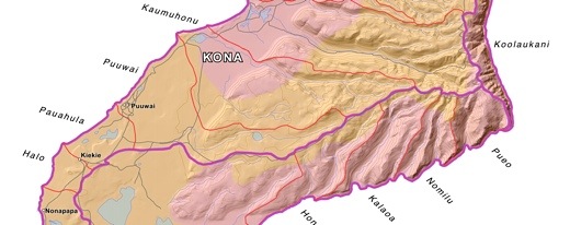
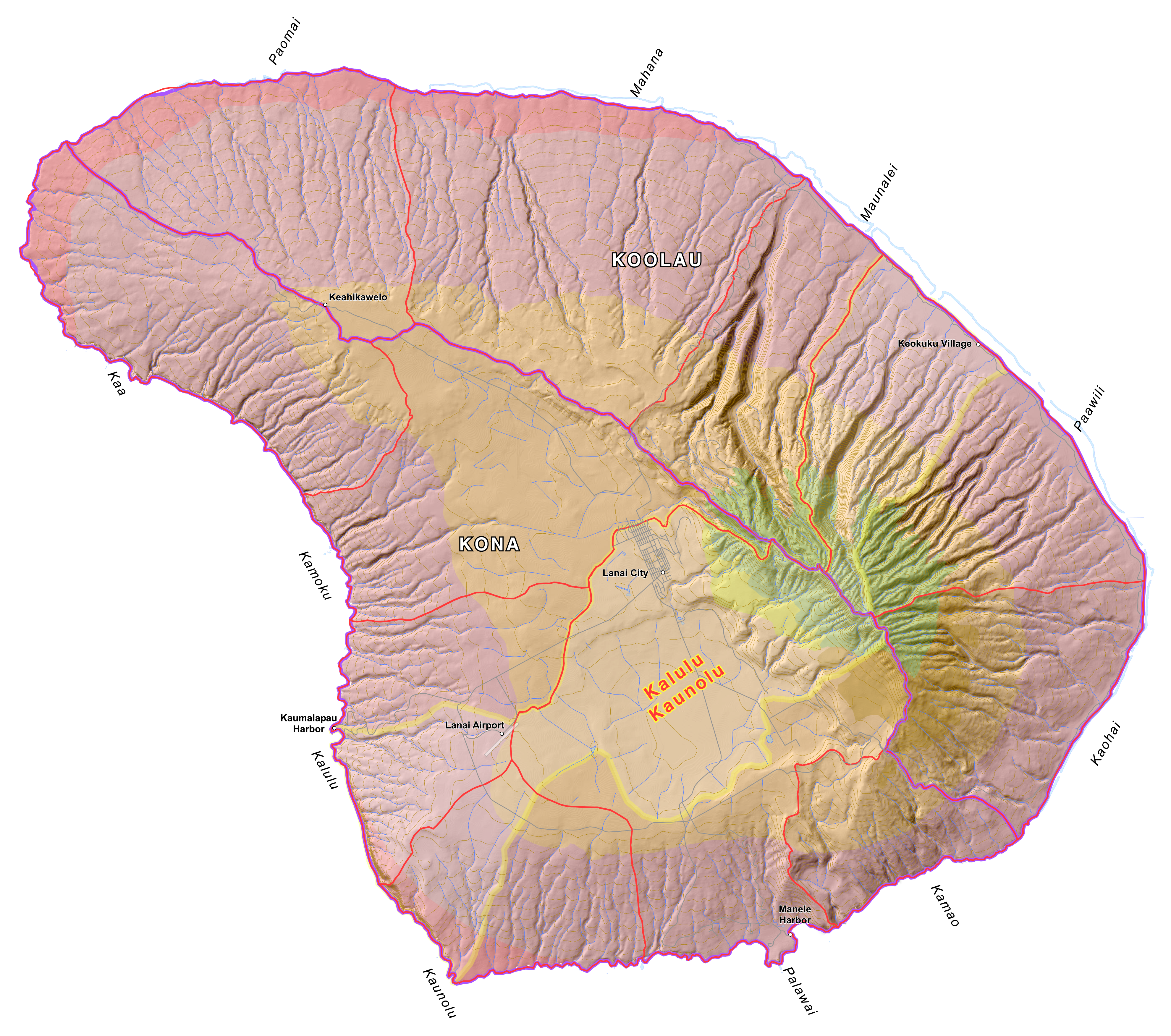
Image above: Map of Niihau, Hawaii, showing Life Zones, Ahupuaa and Moku. Click to enlarge.
By Juan Wilson
The traditional land divisions of pre-contact Hawaiians was based on the sustainability and self-reliance within community watershed areas (ahupuaa) as well as within bioregions (moku) and lastly individual sovereign islands (mokupuni). These natural land divisions were the result of the flow of water over the land.
We are now beginning to include evidence of the flow of water over and under the surface of the islands. We are calling these areas of consideration Waihona.
For simplicity and efficiency this current work is not being coordinated through the Ahu Moku Committee. Historic documents, reference material and selected kapuna are being consulted. On May 1st 2016 we released the current state of the work to the public.
We welcome comment and criticism. This work is far from complete. Waihona are only partially covered at this time.
The new work can be found by clicking here:
(http://www.islandbreath.org/hawaiinei/hawaiinei.html)
The available downloadable files of Big Island, Maui, Kahoolawe, Lanai Molokai, Oahu, Kauai and Niihau are in the following formats:
GoogleEarth Files - .kmv
Arch D size Plot Files - .pdf
High Resolution Raster Files - .png
ArcView GIS Shape Files - .shp
AutoCad Document Exchage Files - .dxf
The older Ahu Moku work can be found here:
(http://www.islandbreath.org/mokupuni/mokupuni.html)
By Jonathan Jay
Although this work began as an inquiry into the existing historical cartographic documents and collected oral descriptions of the traditional and customary Ahupua`a and Moku land management system of the Polynesian and Hawaiian people, this work is now a synthesis of that historical record combined with contemporary Western ecological and environmental frameworks, adapted to existing present conditions.
As such, this work is no longer an attempt to accurately recreate the boundaries of ahupua'a or moku divisions at a particular point in history. Instead, by attempting to discern the principles and frameworks of understanding that allowed for the creation of organic divisions of land in the first place, we now strive to apply these principles to our contemporary conditions - 'Ahupua`a & Moku for the 3rd Millennium' if you will. It is our hope that this work will provide the basis for prudent, long-range, sustainable land-use and resource management.
.
By Juan Wilson & Jonathan Jay on 2 May 2016 for Island Breath-
(http://islandbreath.blogspot.com/2016/05/introduction-to-hawaiian-land-areas.html)
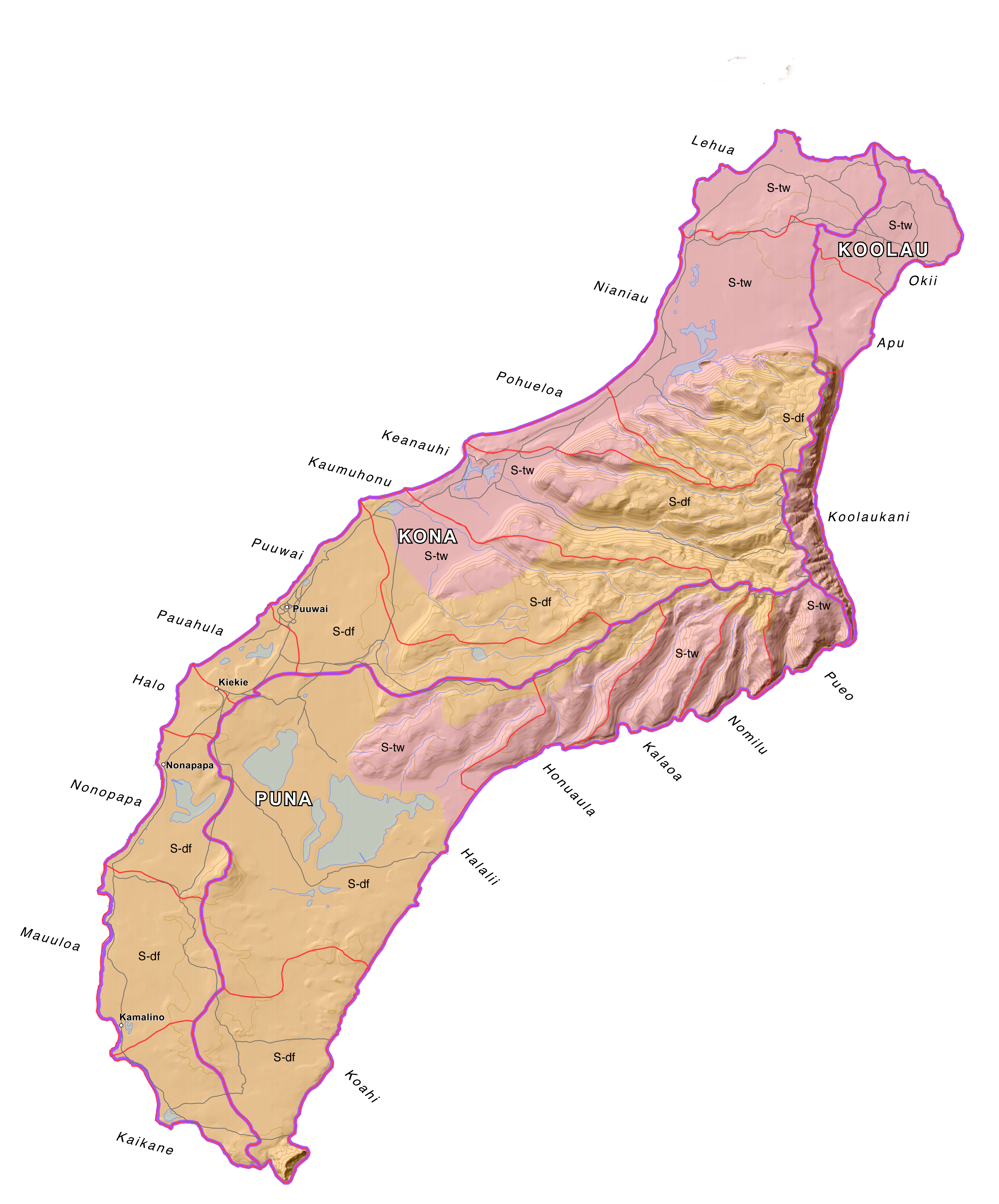
Image above: Map of Niihau, Hawaii, showing Life Zones, Ahupuaa and Moku. Click to enlarge.
By Juan Wilson
The traditional land divisions of pre-contact Hawaiians was based on the sustainability and self-reliance within community watershed areas (ahupuaa) as well as within bioregions (moku) and lastly individual sovereign islands (mokupuni). These natural land divisions were the result of the flow of water over the land.
We are now beginning to include evidence of the flow of water over and under the surface of the islands. We are calling these areas of consideration Waihona.
For simplicity and efficiency this current work is not being coordinated through the Ahu Moku Committee. Historic documents, reference material and selected kapuna are being consulted. On May 1st 2016 we released the current state of the work to the public.
We welcome comment and criticism. This work is far from complete. Waihona are only partially covered at this time.
The new work can be found by clicking here:
(http://www.islandbreath.org/hawaiinei/hawaiinei.html)
The available downloadable files of Big Island, Maui, Kahoolawe, Lanai Molokai, Oahu, Kauai and Niihau are in the following formats:
GoogleEarth Files - .kmv
Arch D size Plot Files - .pdf
High Resolution Raster Files - .png
ArcView GIS Shape Files - .shp
AutoCad Document Exchage Files - .dxf
The older Ahu Moku work can be found here:
(http://www.islandbreath.org/mokupuni/mokupuni.html)
By Jonathan Jay
Although this work began as an inquiry into the existing historical cartographic documents and collected oral descriptions of the traditional and customary Ahupua`a and Moku land management system of the Polynesian and Hawaiian people, this work is now a synthesis of that historical record combined with contemporary Western ecological and environmental frameworks, adapted to existing present conditions.
As such, this work is no longer an attempt to accurately recreate the boundaries of ahupua'a or moku divisions at a particular point in history. Instead, by attempting to discern the principles and frameworks of understanding that allowed for the creation of organic divisions of land in the first place, we now strive to apply these principles to our contemporary conditions - 'Ahupua`a & Moku for the 3rd Millennium' if you will. It is our hope that this work will provide the basis for prudent, long-range, sustainable land-use and resource management.
.
No comments :
Post a Comment