SUBHEAD: Kuapapa means united under one chief. Bullshit. Niihau isn't a moku of Kauai. Mana is a moku of Kauai.
By Juan Wilson on 14 May 2017 for Island Breath -
(http://islandbreath.blogspot.com/2017/05/kauai-nui-kuapapa.html)
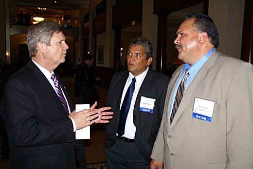
Image above: A heavily sweating Kauai Mayor Carvalho and Big Island Mayor Kenoi are being "man-splained" how GMO and pesticide policy will go down in Hawaii by Secretary of Agriculture Thomas Vilsack in a meeting in 2011. Vilsack was a former governor of Iowa and an early supporter of corn ethanol production. He had also been a lobbyist and Vice President of Monsanto corporation. Glyphoste is in his blood. From (https://damontucker.wordpress.com/tag/mayor-bernard-carvalho/).
Recently I received a mailing purportedly from Bernard Carvalho to "talk about Nui Kuapapa" - "to talk about our island". The mailing invited me to identify which moku I live in from a provided map of Kauai and Niihau. The map was first seen in the drafts of the proposed Kauai General Plan Update 2020.
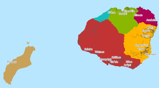
Image above: Map of Kauai and Niihau from the draft of the General Plan Update showing Niihau as a moku of Kauai and Kona moku flooding into half of the Napali moku from Haeleele to Nualolo. See also (http://kauainuikuapapa.com/moku/kona/).
Note, this map does conform to historic moku borders in some ways. Certainly Halelea, Koolau, and Puna are reasonable representations according to many, but not all cultural interpretations. As in many modern maps no Mana Moku is shown. Mana is subsumed by Kona.
But in addition the Napali Moku has been shriveled by half as Kona has engulfed much of the western Napali ahupuaa from Haeleele to Nualolo, including Milolii. Since when has Milolii not been considered on the Napali Coast?
To see how shallow this cultural vision of Kauai is check out the source (http://kauainuikuapapa.com/#home). The creators of this site are linked to the General Plan effort and reveal something interesting when you get down to the contacts page:
The General Plan Update process pretends to be a gathering of our community voices to determine our future. It uses Hawaiian words to pretend it shares Hawaiian cultural perspective. It is presented in an informal style with lots of images of local people and places, but as merely props and scenery to disguise its true purpose - ECONOMIC DEVELOPMENT... particularly for tourism and real estate development.
Because this is a Kauai County government project it is seen from a county political perspective, Niihau has been reduced to an appendage of Kauai.
From the get-go the County Planning Department has had the goal that the General Plan Update 2020 will implement a doubling of the population of Kauai in the next generation. It calls for a tripling of the population in the Hanapepe-Elelele area and a significant increase in military operations (and personnel) on the Westside.
Niihau is not a moku of Kauai!
Hawaiian language definitions, like English, are multidimensional. In general "moku" means a cut piece of something, and a "puni" means surrounded as by water.
Maui has had a similar fate. At one time Maui was an island that included Molokai, Lanai and Kahoolawe. As it was eroded and broken into separate islands over geological time each part became a mokupuni unto itself.
But this is clear. All Hawaiian inhabited Hawaiian islands have an identified windward and leeward side (or Kona and Koolau moku).
Mana is a moku of Kauai!
Before I detail why, I must tell you I've been mapping the moku of Kauai for over a decade. In 2009 I was approached by Jean Ileialoha Beniamina to map the moku and ahupuaa of all the Hawaiian islands. She was then Chair of the Aha Kiole Committee (later to become the Aha Moku Council).
The committee and council sought kapuna and others with knowledge of historic Hawaiian land management and the names and places of moku and ahupuaa to report on each island.
I was commissioned by the Western Pacific Regional Fisheries Management Council (WesPac) through funds from the US National Ocean & Atmospheric Administration (NOAA) to do that mapping according to the reports of the Aha Moku Council.
In 2010 the maps I produced were accepted as complete. Some adjustments were made and corrections submitted by Ahu Moku participants and others who saw the maps once published and made available to the public. The results of that effort can be found at (http://www.islandbreath.org/mokupuni/mokupuni.html).
The Kauai map specifically can be found at (http://www.islandbreath.org/mokupuni/M7Kauai/M7KauaiRasterFile.png). The kauai and the other island maps can be found at the Aha Moku Council website here (http://www.ahamoku.org/index.php/maps/).
In studying the issues I came across two vital sources. One was Mrs. Ursula S. Emerson, the wife of minister Rev. John S. Emerson of Kauai. In conjunction with local Hawaiians she mapped Kauai, Niihau and Oahu.
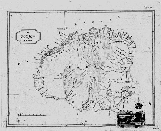
Image above: The 1833 map of Kauai by Ursula Emerson, wife of Reverend John Emerson of Koloa. In my opinion this is the finest map of Kauai until four decades later. It had the best proportions features and selection of detail until after the overthrow of Hawaiian sovereignty. This copy came from the Kauai Historical Society. For some unaccountable reason the title block of the maps was mutilated. Click to enlarge and see full image.
This map of Kauai is dated 1833. Besides sailor's navigational maps, this is the first coherent map of Kauai. It identifies streams and renders interior valleys and ridges. The map also show the Great Ala Loa Trail and the ahupuaa and moku of the island. I consider it the most accurate map of Kauai until after the Great Mahhele. It shows clearly six moku on Kauai, the westernmost one being Mana Moku. Her Kauai map was used a a basis for the US Navy and British Navy maps of the late 1830’s.
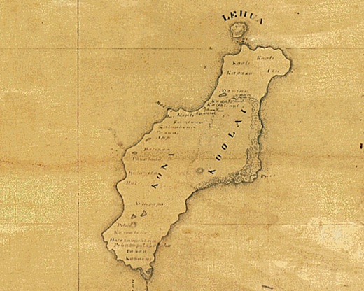
Image above: Detail of the 1833 map of Niihau by Ursela Emerson. Click for complete map.
The Emerson map of Niihau distinctly identifies two moku - Kona and Koolau. It, like her map of Kauai, shows a detailed knowledge of shoreline, features and place names. Her maps were done in Hawaiian language and my understanding is that local Hawaiians were the source of her detailed knowledge of the islands.

Image above: Detail of Kauai island from 1838 map of Hawaiian Islands by S. P. Kalama.
Also, Simon Peter Kalama of Maui’s Lahaina Luna School was the first Hawaiian to map the Hawaiian Islands in 1837 and more accurately in 1838). He clearly shows Mana as a moku of Kauai and Niihau with a Kona and Koolau moku. See (http://islandbreath.blogspot.com/2010/06/na-mokupuni-o-hawaii-nei.html).
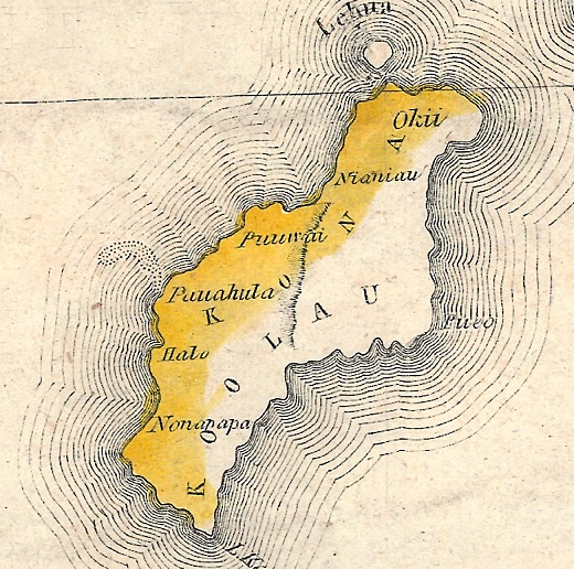
Image above: Detail of Niihau Island from 1838 map of Hawaiian Islands by S. P. Kalama 1838.
It is not until well after the establishment of private property and the Hawaiian Government Survey map of 1878 did you see Mana as just an area of the westside of Kauai identified as the Moku of Waimea. That continued through the the Territory of Hawaii Map of 1901. Only later was area changed to be part Kona Moku.
I wrote to the partner at Nahokuwelo.com of this matter over a week ago saying I was prepared to work with him on the issues concerning Moku and Ahupuaa on Kauai and Niihau, needless to say, I got no reply.
If the cultural and historic confusion represented by the General Plan Update maps of moku on Kauai and Niihau are representative of the quality of the General Plan then woe be it unto Kauai and Niihau.
.
By Juan Wilson on 14 May 2017 for Island Breath -
(http://islandbreath.blogspot.com/2017/05/kauai-nui-kuapapa.html)

Image above: A heavily sweating Kauai Mayor Carvalho and Big Island Mayor Kenoi are being "man-splained" how GMO and pesticide policy will go down in Hawaii by Secretary of Agriculture Thomas Vilsack in a meeting in 2011. Vilsack was a former governor of Iowa and an early supporter of corn ethanol production. He had also been a lobbyist and Vice President of Monsanto corporation. Glyphoste is in his blood. From (https://damontucker.wordpress.com/tag/mayor-bernard-carvalho/).
Recently I received a mailing purportedly from Bernard Carvalho to "talk about Nui Kuapapa" - "to talk about our island". The mailing invited me to identify which moku I live in from a provided map of Kauai and Niihau. The map was first seen in the drafts of the proposed Kauai General Plan Update 2020.

Image above: Map of Kauai and Niihau from the draft of the General Plan Update showing Niihau as a moku of Kauai and Kona moku flooding into half of the Napali moku from Haeleele to Nualolo. See also (http://kauainuikuapapa.com/moku/kona/).
Note, this map does conform to historic moku borders in some ways. Certainly Halelea, Koolau, and Puna are reasonable representations according to many, but not all cultural interpretations. As in many modern maps no Mana Moku is shown. Mana is subsumed by Kona.
But in addition the Napali Moku has been shriveled by half as Kona has engulfed much of the western Napali ahupuaa from Haeleele to Nualolo, including Milolii. Since when has Milolii not been considered on the Napali Coast?
To see how shallow this cultural vision of Kauai is check out the source (http://kauainuikuapapa.com/#home). The creators of this site are linked to the General Plan effort and reveal something interesting when you get down to the contacts page:
Nā Hōkū Welo, LLCIn my opinion, the map, as a part of the presentation of the entire General Plan Update Plan process, shares a false Hawaiian cultural patina. The map shows Kauai County - that is the islands of Kauai and Niihau. It show five moku on Kauai and show Niihau as a moku of Kauai. Moreover, the moku are not in conformance with the earliest Hawaiian maps prior to the introduction of private property.
P.O. Box 511
Līhue, HI 96766
Phone (808) 779-9454
Fax (855) 251-5425
partner@nahokuwelo.com
Nalani K. Brun
Economic Development Specialist IV-Tourism
Office of Economic Development
County of Kauai
4444 Rice St. Suite 200
Līhue, HI 96766
Phone (808) 241-4952
Fax (808) 241-6399
nbrun@kauai.gov
The General Plan Update process pretends to be a gathering of our community voices to determine our future. It uses Hawaiian words to pretend it shares Hawaiian cultural perspective. It is presented in an informal style with lots of images of local people and places, but as merely props and scenery to disguise its true purpose - ECONOMIC DEVELOPMENT... particularly for tourism and real estate development.
Because this is a Kauai County government project it is seen from a county political perspective, Niihau has been reduced to an appendage of Kauai.
From the get-go the County Planning Department has had the goal that the General Plan Update 2020 will implement a doubling of the population of Kauai in the next generation. It calls for a tripling of the population in the Hanapepe-Elelele area and a significant increase in military operations (and personnel) on the Westside.
Niihau is not a moku of Kauai!
Hawaiian language definitions, like English, are multidimensional. In general "moku" means a cut piece of something, and a "puni" means surrounded as by water.
Moku (Parker Hawaiian Dictionary)It is true that Kauai and Niihau were at one time part of a single larger island rivaling the Big Island and included the tiny island of Kaula further to the southwest of Niihau. Niihau maybe politically part of Kauai County but it is a separate inhabited island and a mokupuni unto itself.
A district; a division of an island, as Kona on Hawaii, and Hana on Maui.
Mokupuni (Parker Hawaiian Dictionary)
The full form for island; that is, a division of land surrounded by water.
Maui has had a similar fate. At one time Maui was an island that included Molokai, Lanai and Kahoolawe. As it was eroded and broken into separate islands over geological time each part became a mokupuni unto itself.
But this is clear. All Hawaiian inhabited Hawaiian islands have an identified windward and leeward side (or Kona and Koolau moku).
Mana is a moku of Kauai!
Before I detail why, I must tell you I've been mapping the moku of Kauai for over a decade. In 2009 I was approached by Jean Ileialoha Beniamina to map the moku and ahupuaa of all the Hawaiian islands. She was then Chair of the Aha Kiole Committee (later to become the Aha Moku Council).
The committee and council sought kapuna and others with knowledge of historic Hawaiian land management and the names and places of moku and ahupuaa to report on each island.
I was commissioned by the Western Pacific Regional Fisheries Management Council (WesPac) through funds from the US National Ocean & Atmospheric Administration (NOAA) to do that mapping according to the reports of the Aha Moku Council.
In 2010 the maps I produced were accepted as complete. Some adjustments were made and corrections submitted by Ahu Moku participants and others who saw the maps once published and made available to the public. The results of that effort can be found at (http://www.islandbreath.org/mokupuni/mokupuni.html).
The Kauai map specifically can be found at (http://www.islandbreath.org/mokupuni/M7Kauai/M7KauaiRasterFile.png). The kauai and the other island maps can be found at the Aha Moku Council website here (http://www.ahamoku.org/index.php/maps/).
In studying the issues I came across two vital sources. One was Mrs. Ursula S. Emerson, the wife of minister Rev. John S. Emerson of Kauai. In conjunction with local Hawaiians she mapped Kauai, Niihau and Oahu.

Image above: The 1833 map of Kauai by Ursula Emerson, wife of Reverend John Emerson of Koloa. In my opinion this is the finest map of Kauai until four decades later. It had the best proportions features and selection of detail until after the overthrow of Hawaiian sovereignty. This copy came from the Kauai Historical Society. For some unaccountable reason the title block of the maps was mutilated. Click to enlarge and see full image.
This map of Kauai is dated 1833. Besides sailor's navigational maps, this is the first coherent map of Kauai. It identifies streams and renders interior valleys and ridges. The map also show the Great Ala Loa Trail and the ahupuaa and moku of the island. I consider it the most accurate map of Kauai until after the Great Mahhele. It shows clearly six moku on Kauai, the westernmost one being Mana Moku. Her Kauai map was used a a basis for the US Navy and British Navy maps of the late 1830’s.

Image above: Detail of the 1833 map of Niihau by Ursela Emerson. Click for complete map.
The Emerson map of Niihau distinctly identifies two moku - Kona and Koolau. It, like her map of Kauai, shows a detailed knowledge of shoreline, features and place names. Her maps were done in Hawaiian language and my understanding is that local Hawaiians were the source of her detailed knowledge of the islands.

Image above: Detail of Kauai island from 1838 map of Hawaiian Islands by S. P. Kalama.
Also, Simon Peter Kalama of Maui’s Lahaina Luna School was the first Hawaiian to map the Hawaiian Islands in 1837 and more accurately in 1838). He clearly shows Mana as a moku of Kauai and Niihau with a Kona and Koolau moku. See (http://islandbreath.blogspot.com/2010/06/na-mokupuni-o-hawaii-nei.html).

Image above: Detail of Niihau Island from 1838 map of Hawaiian Islands by S. P. Kalama 1838.
It is not until well after the establishment of private property and the Hawaiian Government Survey map of 1878 did you see Mana as just an area of the westside of Kauai identified as the Moku of Waimea. That continued through the the Territory of Hawaii Map of 1901. Only later was area changed to be part Kona Moku.
I wrote to the partner at Nahokuwelo.com of this matter over a week ago saying I was prepared to work with him on the issues concerning Moku and Ahupuaa on Kauai and Niihau, needless to say, I got no reply.
If the cultural and historic confusion represented by the General Plan Update maps of moku on Kauai and Niihau are representative of the quality of the General Plan then woe be it unto Kauai and Niihau.
.
No comments :
Post a Comment