SUBHEAD: Mana was once a vital wetlands supporting the lives of fish bird and plants - It can be again.
By Juan Wilson on 27 August 2013 for Island Breath -
(http://islandbreath.blogspot.com/2013/08/the-golden-plain.html)

Image above: Vernal ponds on the westside. In this case Puolo Point, near Hanapepe. Photo by Juan Wilson.
An imaginary true story
Imagine you are in Kekaha, Kauai, during a full moon near the Winter Solstice early in the 20th century; or more precisely at sunset on December 19th in 1907. As the sun is setting you are at the western end of Kekaha in a grove of palm trees at the sandy southern edge of a wetland. It is a place the Hawaiians call Pokii.
The bright day is cooling as above you the glow of as the sky turns from orange to a deep purple. You look down again you see a small outrigger canoe slipping across the shallow water. It will soon take you north.
Your guide uses his paddle to pole you into the marshy water as the canoe rocks. It has rained a lot above the Mana plain in the last week and the water has made its way to down to the marsh. After a short while you are gliding through the water in an area fringed with sedge grasses. On either side, beyond the marsh, flooded fields of rice reflect what is left of the twilight.
To your left a thick forest of kiawe borders the marshland. You can barely hear the winter swell crashing on the shore break beyond the trees. A Pueo owl hovers over a clearing in the trees as it hunts for dinner.
On the right are the quarter-mile high cliffs of Mana and above them the grassland on the mantle above. The grassy mantle is divided by forested narrow valleys that cut the land into what look like loaves of bread set side by side. You can see farther when open water widens into the lower part of the 500 or so acres of Kawaiele Pond.
From the valleys along the base of the cliffs a forest of lehua and ohia trees spills. The valleys carry the fast moving rainwater from far above down to the Mana Plain. There along the base of the cliffs the marsh edge is fringed in pili and makaloa grasses.
As the dusk becomes darkness your guide points ahead. The moon is shining brightly on the smooth water. Suddenly there is a flash as a school of young fish leaps through the water and into the air chased by something unseen.
There is a great variety of fish, birds and plants that depend on this expansive wetland for their birth and sustenance. How many we will never know.
The rice paddies are behind you now. You are lucky to have this guide through Kawaiele Pond as it has branches that sprawl in different directions. One way leads to an outlet to the ocean and the village of Waiele in Kaawaloa ahupuaa. There are stone walls lining fishponds near the shore of the village. Here fish enter to spawn in the Mana wetlands. The keike thrive in the warm brackish waters until it's their time.
In the distance there is a flatboat with two of men in it. One holds an oil lamp over the water while another gathers something from the water with a net. Shorebirds used these marshes to breed and hunt the fish too.
You pass through another branch of the pond leading to Limaloa Pond and Hohili beyond. You turn to look behind at the moon. The sky is cloudless. The moon is so bright that at first you do not see the rainbow surrounding it. As your eyes adjust the colors around the moon seem to pulse.
The guide has reached the northern end of Limaloa Pond and he nudges the bow of the canoe into a reedy area that seems solid enough. Above and ahead of you a line of clouds moves slowly with the trades strung down Mana Ridge from the swamp and forests of Kokee. It streches across the channel to Niihau bringing fresh water with it. After a short portage over a sandy area the two of you slip the canoe into the marsh of Nohili Pond in Nonomahiki ahupuaa. The guide navigates the canoe through the grassy area and into open water.
This is not as big as Kawaiele or Limaloa Pond but it has an impressive feature ahead to your left - it glows white in the moonlight with a scattering of dark tree stands on its back - its known to many as Barking Sands. At the peak the sand dunes of Nohili Point are about 100 feat high - the tallest in Hawaii. The beach they sit on is the longest in Hawaii as well, stretching over ten miles uninterrupted from Kekaha to Polihale.
You are tempted to end your trip at south end of Barking Sands. It is certainly about the most spectacular place to survey Mana and the ocean, but you have another goal farther ahead. The northern marshes of Nohili Pond are just ahead. As you drift onto shore you hear the scrape of sand on the canoe's hull.
Once you land you could stay with your guide and go over the next portage and soon reach Kolo Pond close to the cliffs. It is a special place, but your plan is to head toward the old road that skirts the back of the dunes and reach Queen's Pond that lies along the shore of Kolo Ahupuaa. It is not a long walk.
You walk along the old dirt road and in s short while you cross into Kahelunui ahupuaa. The giant sand dunes north of Barking Sands continue there march up the beach with you. Kahelunui is narrow so its not long before you enter into Kolo ahupuaa; not where the pond is back at the cliff, but near the ocean dunes.
The old road passes through a group of giant monkeypod trees Their ancient boughs make semicircular arcs from the massive trunks almost reaching the ground. The trees are the marker to head towards the ocean and Queen's Pond. You hike up the sandy path through kiawe trees that provide the only shade available in the day. The moon is casting its shadows of the treetops in the white sand. You are careful to avoid the thorns of their fallen branches.
The dunes here are high and block the sound of the ocean. However you do hear laughter from the top of the 50 foot dune. The path ramps up to a clearing and you see sparks fly into the sky. You have found your friend's campfire in the dunes protected from the ocean wind. After a brief greeting you're off down the face of the dune heading toward to the ocean and the pond.
Queen's Pond is fully formed next to the ocean, and glistening in the moonlight. Tonight the pond is fat. It lies parallel to the ocean over 700 long by 150 wide. It is probably over your head in the middle.
Being a tidal ocean pond it forms in the sand only under the right conditions. It can disappear in a matter of hours or stay on for weeks. You never quite know if it will be there the next time you come. No one is out here but you and your friends.
You strip off your dusty clothes and touch a toe in the pond. The pond has been in place for couple of sunny weeks so it is warm. You wade in on the sandy bottom. There is a greenish blue flash beneath you. Your feet must have disturbed some bioluminescent algae growing in the pond.
Surprised, you laugh. A friend dives in head first and waves of aqua color light radiate out in front of her. You can see tiny fish dart away as you decide to dive in too - eyes open you see more rainbows.
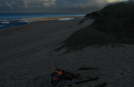
Image above: Looking north towards Queens Pond and Polihale in distance, from the border of Kolo Ahupuaa, Photo by Juan Wilson.
The reality of it all
In 2010 I was asked to map the traditional land areas of the islands of Hawaii. They consist of the moku (roughly bioregions) and ahupuaa (roughly watersheds) of each island.
The indigenous Hawaiians developed a land management system utilizing the moku and ahupuaa to achieve long lasting agricultural and aquaculture practices. Although it was not perfect, it supported people's needs while protecting the environment for a longer time than modern practice has proven to do.
The Hawaiian success, as with most cultures, resulted in higher populations. Pigs escaped domestication and tore up the mountains. Birds became extinct because of the color of their feathers. Limits of acreage in the valleys meant greater difficulty expanding food production. These factors and more meant leaning too hard on the resources of the land.
As Hawaiian population reached into the hundreds of thousands, stricter regulation and control (kapu or taboo) of people increased. These disciplines were needed to maintain a precarious equilibrium with the environment. Even with these difficulties the pre-contact Hawaiians did better protecting the land than those from afar who settled here. By the time of Captain Cook's landing on Kauai, in 1779, growing population was something that Hawaiians already were dealing with. But not for long.
After taking just about every whale in the Atlantic the whalers moved to the Pacific with the attendant missionaries. They brought new diseases that decimated the Hawaiian people. As much damage as they did to Hawaii was only topped by plantations and the military.
The Hawaiians had diverted the fast flowing Waikomo stream and other southside fresh water systems into a sophisticated irrigation system of ditches, loi and fishponds that produced vast amounts of food to support a large population. The Koloa Field system was so productive that it exported yams and sweet potatoes from Koloa Landing to California, to field hungry Forty-Niners during the California Gold Rush. The Hawaiians also had been growing sugarcane for their own use.
By 1835 Ladd & Company had started the first commercially successful industrial sugarcane plantation. Others soon followed. Ditches were dug, reservoirs were built, fields were irrigated.
On the west side of Kauai was the largest level area of land in Hawaii and the second largest wetland after Pearl Harbor. Chris Cook, former editor of the Garden Island News wrote in an article in 11/27/2000:
By the beginning of the 20th century Knudsen and family with the help of Hans Faye had plans for the Kekaha Ditch and the Kokee Ditch, which together diverted the water of the Waimea River and the Alakai Swamp into ditches feeding the upper reaches of Mana Moku near Puu Opae, and the lower flatland of the Mana Plain. Together these fields were the highest and lowest altitude sugarcane fields in operation.
Mana in 1907
In November 1907 a map of the Mana Plain was drawn up using the framework of the US Geological Surveys we still see today. The map appears to be a preliminary map prepared to be part of the Hawaii Territorial Survey under the authority of Walter E. Wall, Surveyor. The map was created by W. L. Heilbron.
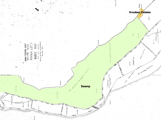
Image above: A preliminary plan of Palt #2422 of Mana was done in November 1907 for Walter E. Wall, surveyor. Click to enlarge. Note we have highlighted swamp in green and Knudsen Estates in yellow.
This preliminary map shows two roads from Kekaha out towards Polihale. One was Government Road along the base of the Mana Cliffs and the other was a road behind the dunes and kiawe forests. Heilbron noted the area with the simple word "Swamp" and noted "4.0' elevation throughout Swamp" above sea level. Only to the southeast extreme, in front of the estates of Augustus and Eric Knudsen, was "Cane" identified.
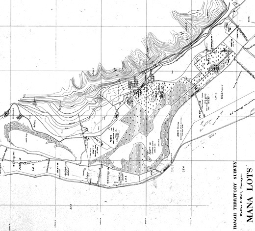
Image above: Hawaiian Territorial Survey Plat #2422 of Mana in December 1907 for Walter E. Wall, surveyor. Click to enlarge.
Only a month later, in December 1907, another map drawn by Heilbron. It the official HTS Plat Registered Map 2422. It shows much greater detail than the November map, including the layout of the town of Mana and the land use on the Mana Plain.
This included much more area planted in rice around specific large ponds and marshes. The largest pond is in Kawaiele Ahupuaa and it and its surrounding marsh were over a thousand acres in area. Another area pond and marsh mauka of Nohili Point was over 400 acres.
This map also shows the expansion of sugarcane planted along the base of the Mana cliffs from Kekaha past Nohili Point. Paralleling mauka of the government road, a rail line extends across the Mana plain to haul cane.
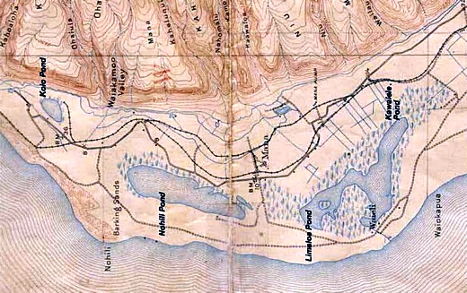
Image above: USGS Mana Quadrangle Map from 1910. Provided by former DLNR Chair Peter Young by way of Hope Kallai. Note village of Waiele (identified as Waieli) a the exit of Kawaiele Pond into the ocean. On later maps Wailele is not shown, but property entitled to "E. Knudsen" takes its place. This was important in that this outlet to the ocean was used to drain the waters of the Mana Plane by Knudsen and his cronies. Click to enlarge.
Peter Young, former chair of the Department of Land & natural Resources for Hawaii wrote on FaceBook 8/26/13:
In May 1920 another HTS Plat Map was done (#3026) for Walter E. Wall drawn by T. J. K. Evans. It is obviously based on the 1907 map and following 1910 USGS map. It labels the wetlands as the Kawaiele Pond Game Reserve (leaving off Limaloa Pond), and shows Hohili Pond Game Reserve.
Another two maps were created in 1921 by T. J. K. Evans for Walter Wall Surveyor. They were Plat 3026-A and Plat 3026-B.
Plat 3026-A shows the area north from Hohili that includes Poli Hale. On that map, north of Nohili Point, an additional marshland area lies mauka of Queen's Pond Beach in the Kolo Ahupuaa. It is labeled Kolo Pond Game Reserve (as does the USGS 1910 map).
These identifications of wetland as a specific pond and game reserve indicate to me some level of regulation of the resources by the Hawaii Territorial Government. Surrounding the Kolo Pond area is shown sugarcane. The land makai of Nohili Pond to the back of the ocean sand dunes is labeled Pastoral Land.
Plat 3026-B shows a more southerly view of Mana Plat 3026. It extends from the northwest near the Knudsens' estates to the southeast and the edge of Waimea Canyon. This is the first Hawaiian Territory Survey that show the route of Kekaha Ditch created by Hans Faye. The Kekaha Ditch diverts the Waimea River water to the Mana Moku for growing sugarcane.
Bad things were in store for the Hawaiians living in Mana the next year. The early surveys of Mana by Walter Wall appear to have been the groundwork for the USGS map of 1910. Unfortunately, they may also have been the base maps for the destruction of the Mana wetlands and replacement by plantation sugarcane. In 1922 Faye began filling in the Mana wetlands.
Wikipedia says about Faye's work:
The town of Mana lingered on for a while as the Kawaiele, Nohili and Kolo ponds and their surrounding wetlands were filled in to make room for more sugar. I have a 1963 USGS map that I have shows about 50 buildings out in Mana town. The town was just a bit southeast (to the right) of the intersection where you turn onto the dirt road to Polihale. In my 1983 USGS map there were less than twenty buildings shown.
Today there are no buildings there. You cannot get there either. There is a gate that is always locked and controlled by Syngenta that keeps prying eyes out of what was once Mana. But long before the people and the places of Mana were disappeared, the Moku name itself was buried. On all maps afterwards, the Kekaha and Kokee ditches were operational the Mana Plain was designated as part of Kona - no longer Mana. That's because it was in Kona where the power was - where the Waimea and Kekaha mills stood.
The town was dismantled after Mana lost its designation as a bioregion in Hawaiian culture. I think that needs correcting. I think for the sake of life itself that Mana's wetlands and ponds should be restored.
Perhaps because Mana as a place no longer has any status it is the place on the island where bad things go to hide. This includes the landfill, the shooting range, the US Navy Pacific Missile Range Facility, the activities of Sandia Labs, DARPA, Raytheon and ITT corporations, as well as the activities of GMO companies like Syngenta. Evil abides there. We call it "Mordor".
The Golden Plain Tomorrow
To heal the island and the ocean, we need to make Mana whole. One meaning of the Hawaiian word mana is "dry land". Certainly much of Mana fits that description much of the year. But the times when parts are wet with rain and connected to the ocean were important - even vital.

Image above: Aha Kiole Advisory Committee Mana Map with historic wetlands from 1907-1910 overlaid. Click to enlarge.
Another meaning for the Hawaiian word mana is "supernatural, miraculous or divine power". The place has some of that too. Spirits move through and beyond the place and will help us heal.
Hawaiian tradition held that the souls of the people, uhane, when separated from their bodies traveled along the cliffs of the northwestern edges of their island and dove from cliffs into the sea to reach the realm of the dead, Po, that was below the sea and beyond the setting sun.
As I understand it, souls migrated up the archipelago from island to island. They finally reached Kauai from Kaena Point on Oahu. Their final journey was to Mana and on to cliffs of Haelele over Polihale, the House of the Spirits. There they dived into the sea to find peace for eternity.
The US military, its corporate weapons building partners (e.g. Sandia Labs, Ratheon, ITT, Lockheed Martin, DARPA), as well as the GMO Chemical companies (like Syngenta DuPont and DOW) and even entities like the Kauai County Landfill and Kauai Shrimp Farm are all occupying and damaging the westside of Kauai and particularly the Mana Moku.
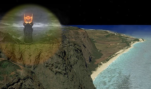
Image above: Near Mount Doom sits Mordor with its flaming eye searching the world for anything it can destroy. Composite illustration using New Age Cinema image of Mordor from the Lord of the Rings film trilogy with a GoogleEarth image looking over Makaha Ridge at the Mana Plain by Juan Wilson. Click to enlarge. From IB post Ea O Ka AIna: Navy plans for Mordor.
It seems an abomination that these things have come to dominate such a supernatural place - this place of Hawaiian spirit.
I am beginning a project to add to the moku and ahupuaa maps. It focuses on Mana Moku. I believe if we can heal Mana we can heal Kauai and ultimately Hawaii. We have much work to do.
For Kauai and the ocean to thrive we need to restore the Mana Plain as birthing and nurturing place for birds, fish and plants that it was. This will require ridding ourselves of the merchants of greed and death.
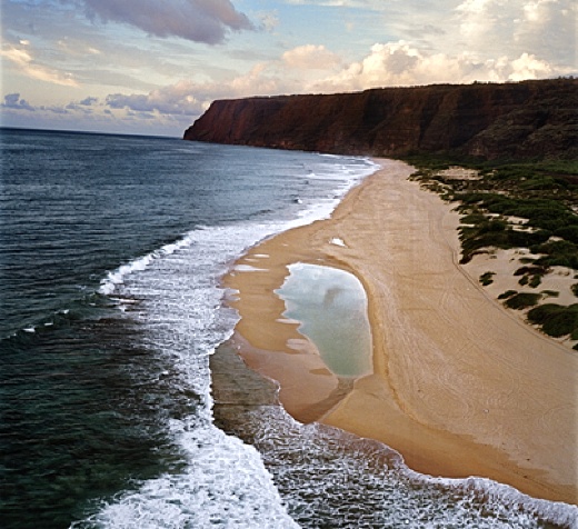
Image above: Queen's Pond, fully formed, as it rarely appears today due to beach erosion. Polihale in the distance and beyond Makaha Ridge. From (http://www.natgeocreative.com/photography/1136837).
.
By Juan Wilson on 27 August 2013 for Island Breath -
(http://islandbreath.blogspot.com/2013/08/the-golden-plain.html)
Image above: Vernal ponds on the westside. In this case Puolo Point, near Hanapepe. Photo by Juan Wilson.
An imaginary true story
Imagine you are in Kekaha, Kauai, during a full moon near the Winter Solstice early in the 20th century; or more precisely at sunset on December 19th in 1907. As the sun is setting you are at the western end of Kekaha in a grove of palm trees at the sandy southern edge of a wetland. It is a place the Hawaiians call Pokii.
The bright day is cooling as above you the glow of as the sky turns from orange to a deep purple. You look down again you see a small outrigger canoe slipping across the shallow water. It will soon take you north.
Your guide uses his paddle to pole you into the marshy water as the canoe rocks. It has rained a lot above the Mana plain in the last week and the water has made its way to down to the marsh. After a short while you are gliding through the water in an area fringed with sedge grasses. On either side, beyond the marsh, flooded fields of rice reflect what is left of the twilight.
To your left a thick forest of kiawe borders the marshland. You can barely hear the winter swell crashing on the shore break beyond the trees. A Pueo owl hovers over a clearing in the trees as it hunts for dinner.
On the right are the quarter-mile high cliffs of Mana and above them the grassland on the mantle above. The grassy mantle is divided by forested narrow valleys that cut the land into what look like loaves of bread set side by side. You can see farther when open water widens into the lower part of the 500 or so acres of Kawaiele Pond.
From the valleys along the base of the cliffs a forest of lehua and ohia trees spills. The valleys carry the fast moving rainwater from far above down to the Mana Plain. There along the base of the cliffs the marsh edge is fringed in pili and makaloa grasses.
As the dusk becomes darkness your guide points ahead. The moon is shining brightly on the smooth water. Suddenly there is a flash as a school of young fish leaps through the water and into the air chased by something unseen.
There is a great variety of fish, birds and plants that depend on this expansive wetland for their birth and sustenance. How many we will never know.
The rice paddies are behind you now. You are lucky to have this guide through Kawaiele Pond as it has branches that sprawl in different directions. One way leads to an outlet to the ocean and the village of Waiele in Kaawaloa ahupuaa. There are stone walls lining fishponds near the shore of the village. Here fish enter to spawn in the Mana wetlands. The keike thrive in the warm brackish waters until it's their time.
In the distance there is a flatboat with two of men in it. One holds an oil lamp over the water while another gathers something from the water with a net. Shorebirds used these marshes to breed and hunt the fish too.
You pass through another branch of the pond leading to Limaloa Pond and Hohili beyond. You turn to look behind at the moon. The sky is cloudless. The moon is so bright that at first you do not see the rainbow surrounding it. As your eyes adjust the colors around the moon seem to pulse.
The guide has reached the northern end of Limaloa Pond and he nudges the bow of the canoe into a reedy area that seems solid enough. Above and ahead of you a line of clouds moves slowly with the trades strung down Mana Ridge from the swamp and forests of Kokee. It streches across the channel to Niihau bringing fresh water with it. After a short portage over a sandy area the two of you slip the canoe into the marsh of Nohili Pond in Nonomahiki ahupuaa. The guide navigates the canoe through the grassy area and into open water.
This is not as big as Kawaiele or Limaloa Pond but it has an impressive feature ahead to your left - it glows white in the moonlight with a scattering of dark tree stands on its back - its known to many as Barking Sands. At the peak the sand dunes of Nohili Point are about 100 feat high - the tallest in Hawaii. The beach they sit on is the longest in Hawaii as well, stretching over ten miles uninterrupted from Kekaha to Polihale.
You are tempted to end your trip at south end of Barking Sands. It is certainly about the most spectacular place to survey Mana and the ocean, but you have another goal farther ahead. The northern marshes of Nohili Pond are just ahead. As you drift onto shore you hear the scrape of sand on the canoe's hull.
Once you land you could stay with your guide and go over the next portage and soon reach Kolo Pond close to the cliffs. It is a special place, but your plan is to head toward the old road that skirts the back of the dunes and reach Queen's Pond that lies along the shore of Kolo Ahupuaa. It is not a long walk.
You walk along the old dirt road and in s short while you cross into Kahelunui ahupuaa. The giant sand dunes north of Barking Sands continue there march up the beach with you. Kahelunui is narrow so its not long before you enter into Kolo ahupuaa; not where the pond is back at the cliff, but near the ocean dunes.
The old road passes through a group of giant monkeypod trees Their ancient boughs make semicircular arcs from the massive trunks almost reaching the ground. The trees are the marker to head towards the ocean and Queen's Pond. You hike up the sandy path through kiawe trees that provide the only shade available in the day. The moon is casting its shadows of the treetops in the white sand. You are careful to avoid the thorns of their fallen branches.
The dunes here are high and block the sound of the ocean. However you do hear laughter from the top of the 50 foot dune. The path ramps up to a clearing and you see sparks fly into the sky. You have found your friend's campfire in the dunes protected from the ocean wind. After a brief greeting you're off down the face of the dune heading toward to the ocean and the pond.
Queen's Pond is fully formed next to the ocean, and glistening in the moonlight. Tonight the pond is fat. It lies parallel to the ocean over 700 long by 150 wide. It is probably over your head in the middle.
Being a tidal ocean pond it forms in the sand only under the right conditions. It can disappear in a matter of hours or stay on for weeks. You never quite know if it will be there the next time you come. No one is out here but you and your friends.
You strip off your dusty clothes and touch a toe in the pond. The pond has been in place for couple of sunny weeks so it is warm. You wade in on the sandy bottom. There is a greenish blue flash beneath you. Your feet must have disturbed some bioluminescent algae growing in the pond.
Surprised, you laugh. A friend dives in head first and waves of aqua color light radiate out in front of her. You can see tiny fish dart away as you decide to dive in too - eyes open you see more rainbows.
Image above: Looking north towards Queens Pond and Polihale in distance, from the border of Kolo Ahupuaa, Photo by Juan Wilson.
The reality of it all
In 2010 I was asked to map the traditional land areas of the islands of Hawaii. They consist of the moku (roughly bioregions) and ahupuaa (roughly watersheds) of each island.
The indigenous Hawaiians developed a land management system utilizing the moku and ahupuaa to achieve long lasting agricultural and aquaculture practices. Although it was not perfect, it supported people's needs while protecting the environment for a longer time than modern practice has proven to do.
The Hawaiian success, as with most cultures, resulted in higher populations. Pigs escaped domestication and tore up the mountains. Birds became extinct because of the color of their feathers. Limits of acreage in the valleys meant greater difficulty expanding food production. These factors and more meant leaning too hard on the resources of the land.
As Hawaiian population reached into the hundreds of thousands, stricter regulation and control (kapu or taboo) of people increased. These disciplines were needed to maintain a precarious equilibrium with the environment. Even with these difficulties the pre-contact Hawaiians did better protecting the land than those from afar who settled here. By the time of Captain Cook's landing on Kauai, in 1779, growing population was something that Hawaiians already were dealing with. But not for long.
After taking just about every whale in the Atlantic the whalers moved to the Pacific with the attendant missionaries. They brought new diseases that decimated the Hawaiian people. As much damage as they did to Hawaii was only topped by plantations and the military.
Plantations:Here on the outer island of Kauai we certainly were not immune to the effects of plantations. In fact, it was the observations by missionaries of the rich and productive Koloa Field System of the Hawaiians that inspired the first sugarcane plantation.
The industrialized agriculture (primarily sugarcane and pineapple) that began in the 19th century that was practiced by Americans and Europeans required terraforming the islands to divert water our of the valleys and swamps and to where large fields could be assembled for irrigation of monocultures. The Hawaiians who depended on the natural flow of water in their valley watersheds were not consulted. The practice of Hawaiian culture shriveled. many of those Hawaiians who survived intermarried with imported plantation laborers and they and their progeny ended up in work camps no longer managing their own valleys.
Military:
The US Navy realized quickly that basing a fleet in the Pacific Ocean was a strategic necessity. By 1887 the Navy had exclusive rights on Oahu to repair and fuel ships in the shallow bay that was part of the largest wetland in Hawaii (now Pearl Harbor). Just a few years later a conspiracy between the plantation owners and US military overthrew Hawaiian sovereignty. Pearl Harbor was needed to take down Spanish Imperialism in the Pacific and replace it with an American brand. Pearl Harbor was dredged out and bulkheaded. Docks were built and bilge was jettisoned. What had been a shallow wetlands and marsh rich in plant and wildlife became a machine for the US Navy... which is the single most destructive organization on the planet.
The Hawaiians had diverted the fast flowing Waikomo stream and other southside fresh water systems into a sophisticated irrigation system of ditches, loi and fishponds that produced vast amounts of food to support a large population. The Koloa Field system was so productive that it exported yams and sweet potatoes from Koloa Landing to California, to field hungry Forty-Niners during the California Gold Rush. The Hawaiians also had been growing sugarcane for their own use.
By 1835 Ladd & Company had started the first commercially successful industrial sugarcane plantation. Others soon followed. Ditches were dug, reservoirs were built, fields were irrigated.
On the west side of Kauai was the largest level area of land in Hawaii and the second largest wetland after Pearl Harbor. Chris Cook, former editor of the Garden Island News wrote in an article in 11/27/2000:
...the land (of Mana) was populated by Native Hawaiians who landed canoes at Pokii near Kekaha, which was then but a village marked by a stand of palm trees. Other villages dotted the base of the cliffs that reach sea level at the base of the once marshy Mana Plain, and Lehua forests grew down to the bottom of the cliffs.
The plain would flood following heavy rains, allowing outrigger canoe paddlers to travel freely from Mana to Waimea. Some taro planters there grew their crop atop unique wooden rafts that could rise and drop with the floodwaters...Vladamar Knudsen began operating the Kekaha Sugar Company mill and plantation in 1856. Knudsen drained about 50 acres of the marsh along the Mana Plain and planted the first crop of commercially grown sugarcane there in 1878.
By the beginning of the 20th century Knudsen and family with the help of Hans Faye had plans for the Kekaha Ditch and the Kokee Ditch, which together diverted the water of the Waimea River and the Alakai Swamp into ditches feeding the upper reaches of Mana Moku near Puu Opae, and the lower flatland of the Mana Plain. Together these fields were the highest and lowest altitude sugarcane fields in operation.
Mana in 1907
In November 1907 a map of the Mana Plain was drawn up using the framework of the US Geological Surveys we still see today. The map appears to be a preliminary map prepared to be part of the Hawaii Territorial Survey under the authority of Walter E. Wall, Surveyor. The map was created by W. L. Heilbron.
Image above: A preliminary plan of Palt #2422 of Mana was done in November 1907 for Walter E. Wall, surveyor. Click to enlarge. Note we have highlighted swamp in green and Knudsen Estates in yellow.
This preliminary map shows two roads from Kekaha out towards Polihale. One was Government Road along the base of the Mana Cliffs and the other was a road behind the dunes and kiawe forests. Heilbron noted the area with the simple word "Swamp" and noted "4.0' elevation throughout Swamp" above sea level. Only to the southeast extreme, in front of the estates of Augustus and Eric Knudsen, was "Cane" identified.
Image above: Hawaiian Territorial Survey Plat #2422 of Mana in December 1907 for Walter E. Wall, surveyor. Click to enlarge.
Only a month later, in December 1907, another map drawn by Heilbron. It the official HTS Plat Registered Map 2422. It shows much greater detail than the November map, including the layout of the town of Mana and the land use on the Mana Plain.
This included much more area planted in rice around specific large ponds and marshes. The largest pond is in Kawaiele Ahupuaa and it and its surrounding marsh were over a thousand acres in area. Another area pond and marsh mauka of Nohili Point was over 400 acres.
This map also shows the expansion of sugarcane planted along the base of the Mana cliffs from Kekaha past Nohili Point. Paralleling mauka of the government road, a rail line extends across the Mana plain to haul cane.
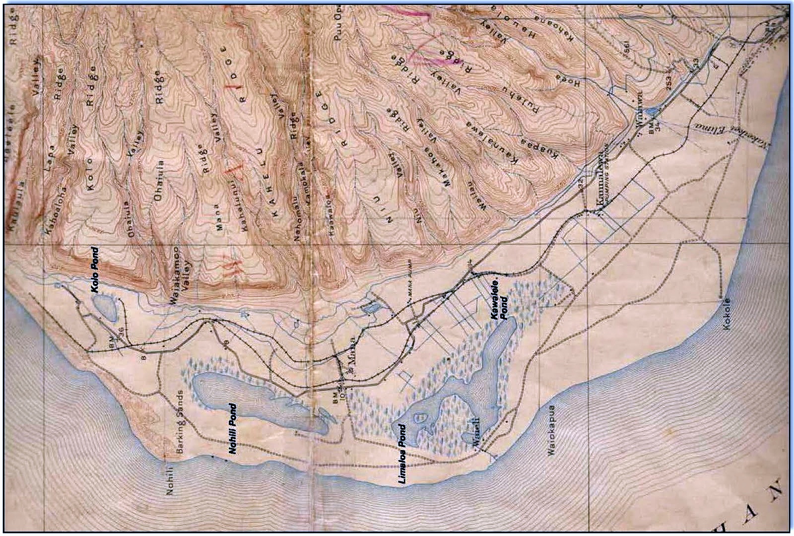
Image above: USGS Mana Quadrangle Map from 1910. Provided by former DLNR Chair Peter Young by way of Hope Kallai. Note village of Waiele (identified as Waieli) a the exit of Kawaiele Pond into the ocean. On later maps Wailele is not shown, but property entitled to "E. Knudsen" takes its place. This was important in that this outlet to the ocean was used to drain the waters of the Mana Plane by Knudsen and his cronies. Click to enlarge.
Peter Young, former chair of the Department of Land & natural Resources for Hawaii wrote on FaceBook 8/26/13:
Mana is a coastal plain with an ancient sea cliff at its inner edge, which extends from Waimea in the south to Barking Sands in the north on the western shores of Kauai. This region has been identified as a leina-a-ka-uhane (paths-for-leaping-by-the-spirit). These were almost always on bluffs looking westward over the ocean, from which the spirits of the dead were believed to plunge in order to enter the spiritual realm.
Throughout prehistory [pre-contact more exactly], large areas of the Mana Plain were covered by the great Mana swamp, allowing the ancients to canoe as far south as Waimea. Up until the mid-1880s, the great Mana swamp, east of the plain, covered large areas of the lowlands.
Approximately 1,700-acres of permanent, semi-permanent and seasonal wetlands were present on the Mana Plain. It is believed that these wet conditions encouraged the independent invention of aquaculture on Kauai and the construction of stone and earthen ponds for growing staples such as taro, yam and sweet potatoes.Mana in 1920-22
Historically, native Hawaiians constructed four different types of fishponds - freshwater taro ponds, other freshwater ponds, brackish water ponds and seawater ponds. Aquaculture was employed to supplement their other fishing activities, and permanent fishponds guaranteed a stable food supply for populations in lean times.
Tended ponds provided fish without requiring fishing expertise, and harvesting the pond, unlike fishing at sea, was not weather dependent. Evidence suggests that Hawaiian fishponds were constructed as early as AD 1000, if not earlier, and continued to be built until the 1820's.
In May 1920 another HTS Plat Map was done (#3026) for Walter E. Wall drawn by T. J. K. Evans. It is obviously based on the 1907 map and following 1910 USGS map. It labels the wetlands as the Kawaiele Pond Game Reserve (leaving off Limaloa Pond), and shows Hohili Pond Game Reserve.
Another two maps were created in 1921 by T. J. K. Evans for Walter Wall Surveyor. They were Plat 3026-A and Plat 3026-B.
Plat 3026-A shows the area north from Hohili that includes Poli Hale. On that map, north of Nohili Point, an additional marshland area lies mauka of Queen's Pond Beach in the Kolo Ahupuaa. It is labeled Kolo Pond Game Reserve (as does the USGS 1910 map).
These identifications of wetland as a specific pond and game reserve indicate to me some level of regulation of the resources by the Hawaii Territorial Government. Surrounding the Kolo Pond area is shown sugarcane. The land makai of Nohili Pond to the back of the ocean sand dunes is labeled Pastoral Land.
Plat 3026-B shows a more southerly view of Mana Plat 3026. It extends from the northwest near the Knudsens' estates to the southeast and the edge of Waimea Canyon. This is the first Hawaiian Territory Survey that show the route of Kekaha Ditch created by Hans Faye. The Kekaha Ditch diverts the Waimea River water to the Mana Moku for growing sugarcane.
Bad things were in store for the Hawaiians living in Mana the next year. The early surveys of Mana by Walter Wall appear to have been the groundwork for the USGS map of 1910. Unfortunately, they may also have been the base maps for the destruction of the Mana wetlands and replacement by plantation sugarcane. In 1922 Faye began filling in the Mana wetlands.
Wikipedia says about Faye's work:
With the draining of the Nohili and Kawaiele Marshes in 1922 and the continued expansion of sugar cane area, another period of well development took place in the 1920s and 1930s.
Initially, this consisted of batteries of closely spaced drilled wells, but Maui-type shafts (tunnels that skim fresh water off the top of the basal aquifer) located along the foot of the bluffs subsequently replaced these.
It was Faye's vision that created the systems and the intricate drainage canals that drained the large swamps of Mana.
In 1926, the Kokee Ditch was completed diverting water from Mohihi Stream and the headwater of the Waimea River in the Alakai Swamp at an altitude of about 3400 feet.The village of Waiele with its few houses at the mouth of Kawaiele Pond never appeared on a map again. It's foundations are under the end of the southern 10,000 runway operated by the PMRF.
About one-fourth of the Kokee Ditch supply has irrigated the highland cane fields below Puu Opae reservoir on Niu Ridge, and the balance has irrigated the highland fields east of Kokee Road.
The town of Mana lingered on for a while as the Kawaiele, Nohili and Kolo ponds and their surrounding wetlands were filled in to make room for more sugar. I have a 1963 USGS map that I have shows about 50 buildings out in Mana town. The town was just a bit southeast (to the right) of the intersection where you turn onto the dirt road to Polihale. In my 1983 USGS map there were less than twenty buildings shown.
Today there are no buildings there. You cannot get there either. There is a gate that is always locked and controlled by Syngenta that keeps prying eyes out of what was once Mana. But long before the people and the places of Mana were disappeared, the Moku name itself was buried. On all maps afterwards, the Kekaha and Kokee ditches were operational the Mana Plain was designated as part of Kona - no longer Mana. That's because it was in Kona where the power was - where the Waimea and Kekaha mills stood.
The town was dismantled after Mana lost its designation as a bioregion in Hawaiian culture. I think that needs correcting. I think for the sake of life itself that Mana's wetlands and ponds should be restored.
Perhaps because Mana as a place no longer has any status it is the place on the island where bad things go to hide. This includes the landfill, the shooting range, the US Navy Pacific Missile Range Facility, the activities of Sandia Labs, DARPA, Raytheon and ITT corporations, as well as the activities of GMO companies like Syngenta. Evil abides there. We call it "Mordor".
The Golden Plain Tomorrow
To heal the island and the ocean, we need to make Mana whole. One meaning of the Hawaiian word mana is "dry land". Certainly much of Mana fits that description much of the year. But the times when parts are wet with rain and connected to the ocean were important - even vital.
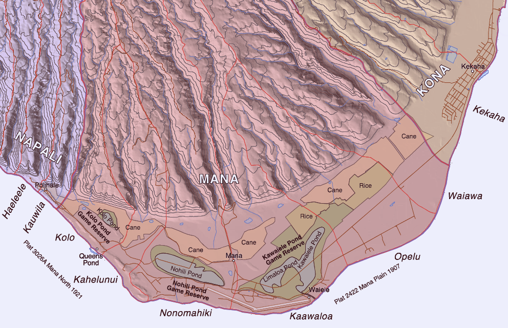
Image above: Aha Kiole Advisory Committee Mana Map with historic wetlands from 1907-1910 overlaid. Click to enlarge.
Another meaning for the Hawaiian word mana is "supernatural, miraculous or divine power". The place has some of that too. Spirits move through and beyond the place and will help us heal.
Hawaiian tradition held that the souls of the people, uhane, when separated from their bodies traveled along the cliffs of the northwestern edges of their island and dove from cliffs into the sea to reach the realm of the dead, Po, that was below the sea and beyond the setting sun.
As I understand it, souls migrated up the archipelago from island to island. They finally reached Kauai from Kaena Point on Oahu. Their final journey was to Mana and on to cliffs of Haelele over Polihale, the House of the Spirits. There they dived into the sea to find peace for eternity.
The US military, its corporate weapons building partners (e.g. Sandia Labs, Ratheon, ITT, Lockheed Martin, DARPA), as well as the GMO Chemical companies (like Syngenta DuPont and DOW) and even entities like the Kauai County Landfill and Kauai Shrimp Farm are all occupying and damaging the westside of Kauai and particularly the Mana Moku.

Image above: Near Mount Doom sits Mordor with its flaming eye searching the world for anything it can destroy. Composite illustration using New Age Cinema image of Mordor from the Lord of the Rings film trilogy with a GoogleEarth image looking over Makaha Ridge at the Mana Plain by Juan Wilson. Click to enlarge. From IB post Ea O Ka AIna: Navy plans for Mordor.
It seems an abomination that these things have come to dominate such a supernatural place - this place of Hawaiian spirit.
I am beginning a project to add to the moku and ahupuaa maps. It focuses on Mana Moku. I believe if we can heal Mana we can heal Kauai and ultimately Hawaii. We have much work to do.
For Kauai and the ocean to thrive we need to restore the Mana Plain as birthing and nurturing place for birds, fish and plants that it was. This will require ridding ourselves of the merchants of greed and death.
Image above: Queen's Pond, fully formed, as it rarely appears today due to beach erosion. Polihale in the distance and beyond Makaha Ridge. From (http://www.natgeocreative.com/photography/1136837).
.
No comments :
Post a Comment