SUBHEAD: This military chemical dump proposal threatens Oahu's Ewa leeward shores.
By Kane Hili on 29 June 2017 for Kanehili News -
(http://kanehili.blogspot.com/2017/06/wetlands-navy-chemical-dump.html)
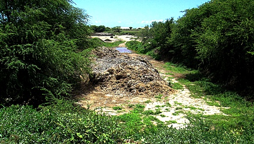
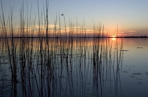
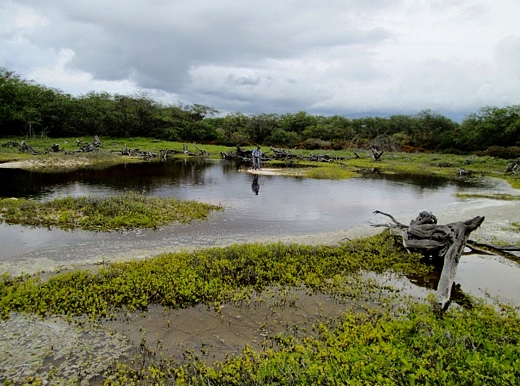
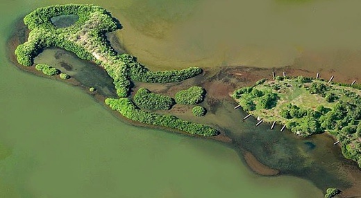
Image above: Site used by migratory and endangered Hawaiian birds has been gradually bulldozed over for Navy use as chemical dump. From original article.
In order to provide members of the community with another opportunity to learn about this site, the Navy will be holding an Open House at Ewa Beach Public and School Library at 7pm on Thursday, June 29, 2017. In addition, the Navy has extended the 30-day public comment period until July 21.
SEND COMMENTS TO:
Denise Emsley
Public Affairs Officer
Naval Facilities Engineering Command Hawaii
400 Marshall Road
JBPHH HI 96860-3139
denise.emsley@navy.mil
808-221-6387 - cel
Ancient Hawaiian Wetlands - Navy Chemical Dump - Threatens Ewa Leeward Shores.
Feedback sought for Navy’s landfill cleanup
By William Cole on 27 June 2017 for the Honolulu Star-Advertiser
http://www.staradvertiser.com/2017/06/27/hawaii-news/more-feedback-sought-for-navys-landfill-cleanup-proposal/
The Navy is extending the public comment period on a proposal to spend $1.2 million to reduce potential exposure to chemicals at a Barbers Point landfill where asbestos and burned waste were dumped between 1942 and 1997. The surface soil contains antimony, lead and hydrocarbons that exceed state Department of Health standards, the Navy said. The Navy is proposing to add cover material, put in place erosion control measures and add perimeter warning signs at the site.


Hiding all this from the public for at least 14 years (and more likely nearly three decades) with an under the radar "public notice" for comment, the Ewa-Kapolei community was shocked and surprised - no neighborhood board notice, no political reps apparently notified - HCDA apparently not notified.
PHOTOS Below show the chemical dump site's natural, cultural history and ecology more complicated than just simple localized chemical dump.
Here's what you likely don't know:
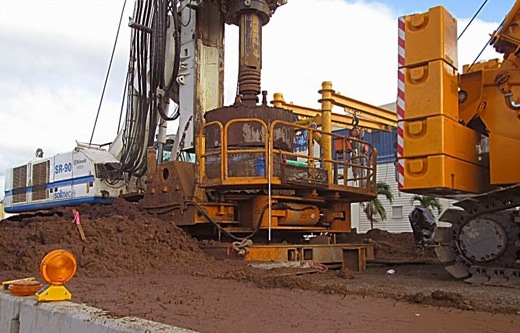
Thermal Desorption Treatment site of PCB-Contaminated Soil, PCB, DDT, Asbestos, Sludge and other hazardous materials brought in to be burned for nearly two decades, maybe more.
Now, the Navy is leaving and wants it off their books and off their inventory. Is what they plan to do sufficient considering future use, site natural, cultural, ecological geography and history?
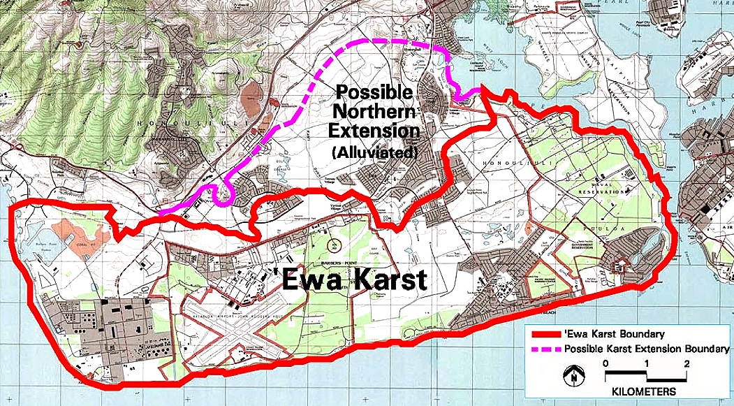
 Stockpiling of Asbestos, PCB and other toxic chemicals for 14 years (or more) without any analysis of heavy rains washing the materials down subsurface karst ancient coral reef waterway channels into the Leeward beach shorelines used for camping, fishing, parties, endangered seals, turtles, limu, etc.
Recent studies found that high levels of lead and other heavy metals on the surface were exposed by recent rains. They very likely have been washing into the shoreline beaches and fisheries for 10-15 years at minimum.
This site is directly adjacent to a Fish & Wildlife endangered species preserve where school children are regularly taken to observe and care take the rare native plants and Opae Ula native shrimp which live in the same underground coral reef brackish water that comes directly wind borne and via subsurface water from this toxic dump.
 Karst ponds and underground channels act as storm drains during heavy rains.
The Navy wants to treat the site by covering it up with more soil, but environmental watchdogs say that's not enough.
A Kapolei landfill is more hazardous than initially thought as clean up options, costs vary
http://www.hawaiinewsnow.com/story/35678630/exclusive-navy-kapolei-landfill-plans-debated
"If they were going to do anything, they should seal it up and treat it like a Brownfield site," Carroll Cox of Envirowatch Inc. said. (Ric Daysog, HNN Story)

 This site is an identifiable ancient natural karst pond and wetlands and ancient Hawaiian habitation area. It was identified as wetlands and ancient Hawaiian sites in the major 1999 Tuggles research down for the closing of the Naval Air Station Barbers point.
https://triadcentral.clu-in.org/user/doc/TPP-BarbersPt-Thermal_Trmt.pdf
Thermal Desorption Treatment of PCB-Contaminated Soil.
Former Naval Air Station Barbers Point. Oahu, Hawaii.
Department of the Navy.
An estimated 26,306 cubic yards of PCB-contaminated soil from 100 sites
at various Navy installations on Oahu were sent to the site for treatment.
Soil from 21 sites totaling more than 5,600 cubic yards had been excavated and
processed through the NAVFAC Kalaeloa site (2003- to ?)
PCB Contaminated soils from military bases all over Oahu, including possibly Kaneohe MCBH where there have been lawsuits filed.
It still has visits by migratory birds, ducks. They have been gradually bulldozing over it but water keeps appearing. It's an ancient karst water pond but they always deny it.

PCB- Short for polychlorinated biphenyl. A family of industrial compounds used as lubricants, heat-transfer fluids, and plasticizers. The manufacture and use of PCBs has been restricted since the 1970s because they are very harmful to the environment, being especially deadly to fish and invertebrates, and stay in the food chain for many years. Most of the toxic materials came from WW-II and 50's-60's era Oahu military bases.
PCB's are found in old electric power transformers as dielectric and coolant fluids. PCBs as definite carcinogens in humans. The maximum allowable contaminant level in drinking water in the United States is set at zero.
The North American producer, Monsanto Company, marketed PCBs under the trade name Aroclor from 1930 to 1977. The commercial production of PCBs started in 1929 but their use has been banned or severely restricted in many countries since the 1970s and 80s.
Dichlorodiphenyltrichloroethane (DDT), DDT and other pesticides had been shown to cause cancer and that their agricultural use was a threat to wildlife, particularly birds. DDE is dichlorodiphenyldichloroethylene-breakdown product of DDT.
DDD (DDT) is dichlorodiphenyldichloroethane
Polycyclic aromatic hydrocarbons (PAHs) are a class of chemicals that occur naturally in coal, crude oil, and gasoline. They also are produced when coal, oil, gas, wood, garbage, and tobacco are burned. Cancer is a primary human health risk of exposure to PAHs.[43] Exposure to PAHs has also been linked with cardiovascular disease and poor fetal development.
Total petroleum hydrocarbons (TPH) is a term used to describe a large family of several hundred chemical compounds that originally come from crude oil.
Also: residual sewage sludge (and what ELSE? we don't know?
Navy admits lapses in Red Hill flow studies
By William Cole on 24 June 2017 in the Honolulu Start Advertiser
http://www.staradvertiser.com/2017/06/24/hawaii-news/navy-admits-lapses-in-red-hill-flow-studies/?HSA=304b9c8e9f0c5c558bbad055d7d009ce4a60bb8f
The U.S. Environmental Protection Agency and state Department of Health sent a June 7 letter criticizing the Navy for providing too little information on water flow modeling to determine where previously spilled fuel might end up, even though the Navy has spent almost two years on the environmental investigation.
A better understanding of groundwater flow patterns is a critical step in the investigation of contamination at Red Hill, the EPA said on its website.
“While most parties agree that groundwater generally flows from the mountains to the ocean, there are specific geologic characteristics in the area around Red Hill that may cause some groundwater to flow in directions other than directly towards the ocean,” the EPA said.

Running out the comment clock: Started May 23 - public was not aware.
Navy says they ran notice in daily newspaper which makes it "ok"
Claim they wanted "public comment" but seem to hope they get ZERO as this was
all Under The Radar.
Is there a plan to make this a new City trash dump that has been a hot
potato for many years? Politicians want all trash and toxic substances
dumped in West Oahu and "Wild West" back roads Kalaleoa are ideal. Is this next?
Only now is there admission of a remediation plan, however these toxic
substances were trucked in from all over Oahu since 2003 and stockpiled
for disposal. How much has all the waste leaked into the porous karst
caves and channels down into the shoreline food chain of limu, reef fish,
turtles, seals etc. ? It has all been kept a secret for at least 14 years.
Only discovered two weeks ago, information about the "public notice" and
"public meeting" was already well underway- started May 22 .
https://triadcentral.clu-in.org/user/doc/TPP-BarbersPt-Thermal_Trmt.pdf
Thermal Desorption Treatment of PCB-Contaminated Soil.
Former Naval Air Station Barbers Point. Oahu, Hawaii.
Department of the Navy.
An estimated 26,306 cubic yards of PCB-contaminated soil from 100 sites at various Navy installations on Oahu were sent to the site for treatment. Soil from 21 sites totaling more than 5,600 cubic yards had been excavated and processed through the NAVFAC Kalaeloa site (2003- to ?)
PCB Contaminated soils from military bases all over Oahu, including Kaneohe MCBH where there have been lawsuits filed.
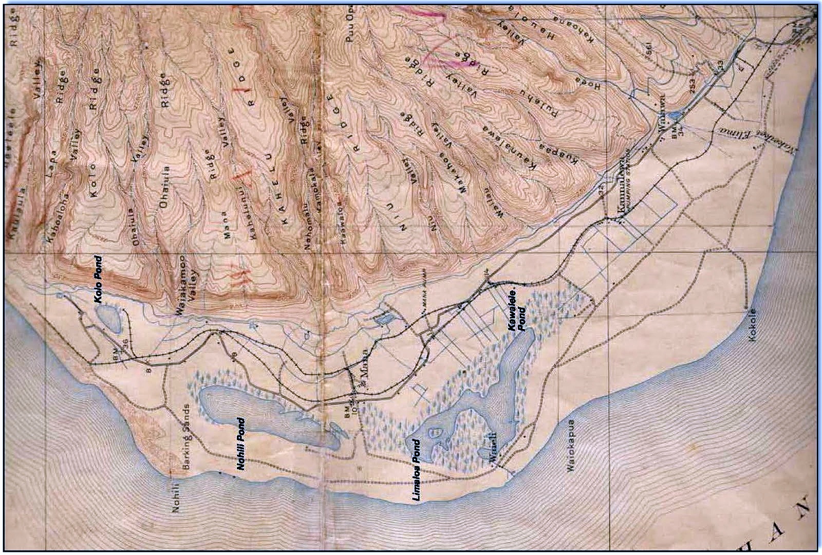
Site At Kalaeloa Was Freshwater Pond Before WW-II, 2003 Navy Turned It Into Turned Into PCB Toxic Dump
Still visited by migratory birds, ducks. They have been gradually bulldozing over it but water keeps appearing. It's an ancient karst water pond wetlands but the Navy denies it. 1928 air photos show it was there before WW-II Navy airfield, then after base closure was turned into toxic waster disposal site because it was so far away and out of sight. Nobody ever asked any questions.
Feedback sought for Navy’s cleanup
By William Cole on 27 June 32017 for the Honolulu Star Advertiser -
http://www.staradvertiser.com/2017/06/27/hawaii-news/more-feedback-sought-for-navys-landfill-cleanup-proposal/
The Navy is extending the public comment period on a proposal to spend $1.2 million to reduce potential exposure to chemicals at a Barbers Point landfill where asbestos and burned waste were dumped between 1942 and 1997. The surface soil contains antimony, lead and hydrocarbons that exceed state Department of Health standards, the Navy said. The Navy is proposing to add cover material, put in place erosion control measures and add perimeter warning signs at the site.
Not one person in the entire community was informed about this Project Plan, including either of the two local neighborhood boards which is where nearly all community projects are presented and questions answered. No one with the Hawaii Community Development Authority were this Navy parcel is located was aware of this plan or the claimed public meeting. A call to all of the local offices of elected officials in the area revealed not one of them or their staff knew about any public meeting.


Suits over toxic soil at Marine Base
SUBHEAD: Residents began to report problems with asthma, cancer and birth defects.
By Chad Blair on 14 December 2014 for Civil Beat -
http://www.civilbeat.org/2016/12/more-suits-filed-over-fears-of-toxic-soil-at-marine-corps-base-hawaii/
Sixty-four military families have now filed suit over fears of pesticide contamination near their homes at Marine Corps Base Hawaii in Kaneohe.
Five separate lawsuits were filed earlier this year by 44 families who said they were not told about the contamination near their homes. On Dec. 8, two more lawsuits were filed on behalf of 20 additional families.
The lawsuits name as defendants Forest City Residential Management and its former subsidiary, Ohana Military Communities, which is owned by military housing developer Hunt Companies.
All of the families leased residential housing at the base sometime from 2006 to 2014. The lawsuits are seeking damages from the defendants that own and manage privatized housing at the base. Ten other unidentified defendants are also named in the suits.
“Since at least 2006, defendants have systematically failed to warn military families of pesticide contamination at MCBH and knowingly and intentionally exposed military families at MCBH to unsafe conditions including higher rates of cancer and other adverse health outcomes without disclosing these risks to military families or taking sufficient steps to protect military families from such risks,” the new claims allege.
The plaintiffs’ attorneys, Kyle Smith and Terrance Revere, declined to comment, and a spokesperson for Ohio-based Forest City said the company does not comment on pending litigation.
The new cases were filed in 1st Circuit Court in Honolulu.
The concerns about potential soil contamination date to 2006, when Ohana Military Communities (then a subsidiary of Forest City) was demolishing homes and buildings. The developer discovered high levels of organochlorine pesticides left over from termite treatments.
Forest City completed a state Department of Health-approved pesticide management plan, which allowed for higher levels of carcinogenic pesticides than the Environmental Protection Agency generally recommends to remain in the surface soil. It was assumed that military families would not live on the base longer than six years, given the frequency or relocations.
But residents also began to report problems with asthma, cancer and birth defects.
Barber, the wife of a Marine Corps veteran who lived on the base for several years, was the lead plaintiff in the initial lawsuit against Forest City in 2014. Barber’s case was later settled out of court.
It’s unclear how much the plaintiffs are seeking, as there are no dollar amounts indicated in the court filings.Damages for emotional distress are also sought.
Navy Seeks comment on waste plan
By William Cole on 16 June 2017 for Honolulu Star-Advertiser

The Navy is seeking public comment on a proposal to spend $1.2 million to reduce potential exposure to chemicals at a Barbers Point landfill where asbestos and burned municipal waste were in trash dumped between 1942 and 1997. Surface soil contains antimony, lead and hydrocarbons that exceed state Department of Health action levels, the Navy said.
By Kane Hili on 29 June 2017 for Kanehili News -
(http://kanehili.blogspot.com/2017/06/wetlands-navy-chemical-dump.html)
Image above: Site used by migratory and endangered Hawaiian birds has been gradually bulldozed over for Navy use as chemical dump. From original article.
In order to provide members of the community with another opportunity to learn about this site, the Navy will be holding an Open House at Ewa Beach Public and School Library at 7pm on Thursday, June 29, 2017. In addition, the Navy has extended the 30-day public comment period until July 21.
SEND COMMENTS TO:
Denise Emsley
Public Affairs Officer
Naval Facilities Engineering Command Hawaii
400 Marshall Road
JBPHH HI 96860-3139
denise.emsley@navy.mil
808-221-6387 - cel
Ancient Hawaiian Wetlands - Navy Chemical Dump - Threatens Ewa Leeward Shores.
Feedback sought for Navy’s landfill cleanup
By William Cole on 27 June 2017 for the Honolulu Star-Advertiser
http://www.staradvertiser.com/2017/06/27/hawaii-news/more-feedback-sought-for-navys-landfill-cleanup-proposal/
The Navy is extending the public comment period on a proposal to spend $1.2 million to reduce potential exposure to chemicals at a Barbers Point landfill where asbestos and burned waste were dumped between 1942 and 1997. The surface soil contains antimony, lead and hydrocarbons that exceed state Department of Health standards, the Navy said. The Navy is proposing to add cover material, put in place erosion control measures and add perimeter warning signs at the site.
Under The Radar: Ancient Ewa Freshwater Karst Pond Wetlands- Navy PCB Toxic Waste Dump


Hiding all this from the public for at least 14 years (and more likely nearly three decades) with an under the radar "public notice" for comment, the Ewa-Kapolei community was shocked and surprised - no neighborhood board notice, no political reps apparently notified - HCDA apparently not notified.
PHOTOS Below show the chemical dump site's natural, cultural history and ecology more complicated than just simple localized chemical dump.
Here's what you likely don't know:
Thermal Desorption Treatment site of PCB-Contaminated Soil, PCB, DDT, Asbestos, Sludge and other hazardous materials brought in to be burned for nearly two decades, maybe more.
Now, the Navy is leaving and wants it off their books and off their inventory. Is what they plan to do sufficient considering future use, site natural, cultural, ecological geography and history?

Recent studies found that high levels of lead and other heavy metals on the surface were exposed by recent rains. They very likely have been washing into the shoreline beaches and fisheries for 10-15 years at minimum.
This site is directly adjacent to a Fish & Wildlife endangered species preserve where school children are regularly taken to observe and care take the rare native plants and Opae Ula native shrimp which live in the same underground coral reef brackish water that comes directly wind borne and via subsurface water from this toxic dump.

The Navy wants to treat the site by covering it up with more soil, but environmental watchdogs say that's not enough.
A Kapolei landfill is more hazardous than initially thought as clean up options, costs vary
http://www.hawaiinewsnow.com/story/35678630/exclusive-navy-kapolei-landfill-plans-debated
"If they were going to do anything, they should seal it up and treat it like a Brownfield site," Carroll Cox of Envirowatch Inc. said. (Ric Daysog, HNN Story)


https://triadcentral.clu-in.org/user/doc/TPP-BarbersPt-Thermal_Trmt.pdf
Thermal Desorption Treatment of PCB-Contaminated Soil.
Former Naval Air Station Barbers Point. Oahu, Hawaii.
Department of the Navy.
An estimated 26,306 cubic yards of PCB-contaminated soil from 100 sites
at various Navy installations on Oahu were sent to the site for treatment.
Soil from 21 sites totaling more than 5,600 cubic yards had been excavated and
processed through the NAVFAC Kalaeloa site (2003- to ?)
PCB Contaminated soils from military bases all over Oahu, including possibly Kaneohe MCBH where there have been lawsuits filed.
Site Used By Migratory and Endangered Hawaiian Birds
It still has visits by migratory birds, ducks. They have been gradually bulldozing over it but water keeps appearing. It's an ancient karst water pond but they always deny it.

What Chemicals Have Been Stockpiled There?
PCB- Short for polychlorinated biphenyl. A family of industrial compounds used as lubricants, heat-transfer fluids, and plasticizers. The manufacture and use of PCBs has been restricted since the 1970s because they are very harmful to the environment, being especially deadly to fish and invertebrates, and stay in the food chain for many years. Most of the toxic materials came from WW-II and 50's-60's era Oahu military bases.
PCB's are found in old electric power transformers as dielectric and coolant fluids. PCBs as definite carcinogens in humans. The maximum allowable contaminant level in drinking water in the United States is set at zero.
The North American producer, Monsanto Company, marketed PCBs under the trade name Aroclor from 1930 to 1977. The commercial production of PCBs started in 1929 but their use has been banned or severely restricted in many countries since the 1970s and 80s.
Dichlorodiphenyltrichloroethane (DDT), DDT and other pesticides had been shown to cause cancer and that their agricultural use was a threat to wildlife, particularly birds. DDE is dichlorodiphenyldichloroethylene-breakdown product of DDT.
DDD (DDT) is dichlorodiphenyldichloroethane
Polycyclic aromatic hydrocarbons (PAHs) are a class of chemicals that occur naturally in coal, crude oil, and gasoline. They also are produced when coal, oil, gas, wood, garbage, and tobacco are burned. Cancer is a primary human health risk of exposure to PAHs.[43] Exposure to PAHs has also been linked with cardiovascular disease and poor fetal development.
Total petroleum hydrocarbons (TPH) is a term used to describe a large family of several hundred chemical compounds that originally come from crude oil.
Also: residual sewage sludge (and what ELSE? we don't know?
Navy admits lapses in Red Hill flow studies
By William Cole on 24 June 2017 in the Honolulu Start Advertiser
http://www.staradvertiser.com/2017/06/24/hawaii-news/navy-admits-lapses-in-red-hill-flow-studies/?HSA=304b9c8e9f0c5c558bbad055d7d009ce4a60bb8f
The U.S. Environmental Protection Agency and state Department of Health sent a June 7 letter criticizing the Navy for providing too little information on water flow modeling to determine where previously spilled fuel might end up, even though the Navy has spent almost two years on the environmental investigation.
A better understanding of groundwater flow patterns is a critical step in the investigation of contamination at Red Hill, the EPA said on its website.
“While most parties agree that groundwater generally flows from the mountains to the ocean, there are specific geologic characteristics in the area around Red Hill that may cause some groundwater to flow in directions other than directly towards the ocean,” the EPA said.

Location of the site in Google Maps
Running out the comment clock: Started May 23 - public was not aware.
Navy says they ran notice in daily newspaper which makes it "ok"
Claim they wanted "public comment" but seem to hope they get ZERO as this was
all Under The Radar.
Is there a plan to make this a new City trash dump that has been a hot
potato for many years? Politicians want all trash and toxic substances
dumped in West Oahu and "Wild West" back roads Kalaleoa are ideal. Is this next?
Only now is there admission of a remediation plan, however these toxic
substances were trucked in from all over Oahu since 2003 and stockpiled
for disposal. How much has all the waste leaked into the porous karst
caves and channels down into the shoreline food chain of limu, reef fish,
turtles, seals etc. ? It has all been kept a secret for at least 14 years.
Only discovered two weeks ago, information about the "public notice" and
"public meeting" was already well underway- started May 22 .
https://triadcentral.clu-in.org/user/doc/TPP-BarbersPt-Thermal_Trmt.pdf
Thermal Desorption Treatment of PCB-Contaminated Soil.
Former Naval Air Station Barbers Point. Oahu, Hawaii.
Department of the Navy.
An estimated 26,306 cubic yards of PCB-contaminated soil from 100 sites at various Navy installations on Oahu were sent to the site for treatment. Soil from 21 sites totaling more than 5,600 cubic yards had been excavated and processed through the NAVFAC Kalaeloa site (2003- to ?)
PCB Contaminated soils from military bases all over Oahu, including Kaneohe MCBH where there have been lawsuits filed.
Site At Kalaeloa Was Freshwater Pond Before WW-II, 2003 Navy Turned It Into Turned Into PCB Toxic Dump
Still visited by migratory birds, ducks. They have been gradually bulldozing over it but water keeps appearing. It's an ancient karst water pond wetlands but the Navy denies it. 1928 air photos show it was there before WW-II Navy airfield, then after base closure was turned into toxic waster disposal site because it was so far away and out of sight. Nobody ever asked any questions.
Feedback sought for Navy’s cleanup
By William Cole on 27 June 32017 for the Honolulu Star Advertiser -
http://www.staradvertiser.com/2017/06/27/hawaii-news/more-feedback-sought-for-navys-landfill-cleanup-proposal/
The Navy is extending the public comment period on a proposal to spend $1.2 million to reduce potential exposure to chemicals at a Barbers Point landfill where asbestos and burned waste were dumped between 1942 and 1997. The surface soil contains antimony, lead and hydrocarbons that exceed state Department of Health standards, the Navy said. The Navy is proposing to add cover material, put in place erosion control measures and add perimeter warning signs at the site.
Not one person in the entire community was informed about this Project Plan, including either of the two local neighborhood boards which is where nearly all community projects are presented and questions answered. No one with the Hawaii Community Development Authority were this Navy parcel is located was aware of this plan or the claimed public meeting. A call to all of the local offices of elected officials in the area revealed not one of them or their staff knew about any public meeting.
NOT AWARE OF NAVY REQUEST FOR PUBLIC COMMENT:
Elected leaders of the Neighborhood Board # 34
Hawaii Community Development Authority (Governor Appointed leaders)
State Senator(s) of the district and surrounding areas
State Representative(s) of the district and surrounding areas
City Council Members of the district and surrounding areas
Adjacent Neighborhood Boards (downstream of potential PCB run-off)
Hawaiian Cultural leaders in the area
Residents of the Kalaeloa community
Click on an image to enlarge.


Suits over toxic soil at Marine Base
SUBHEAD: Residents began to report problems with asthma, cancer and birth defects.
By Chad Blair on 14 December 2014 for Civil Beat -
http://www.civilbeat.org/2016/12/more-suits-filed-over-fears-of-toxic-soil-at-marine-corps-base-hawaii/
Sixty-four military families have now filed suit over fears of pesticide contamination near their homes at Marine Corps Base Hawaii in Kaneohe.
Five separate lawsuits were filed earlier this year by 44 families who said they were not told about the contamination near their homes. On Dec. 8, two more lawsuits were filed on behalf of 20 additional families.
The lawsuits name as defendants Forest City Residential Management and its former subsidiary, Ohana Military Communities, which is owned by military housing developer Hunt Companies.
All of the families leased residential housing at the base sometime from 2006 to 2014. The lawsuits are seeking damages from the defendants that own and manage privatized housing at the base. Ten other unidentified defendants are also named in the suits.
“Since at least 2006, defendants have systematically failed to warn military families of pesticide contamination at MCBH and knowingly and intentionally exposed military families at MCBH to unsafe conditions including higher rates of cancer and other adverse health outcomes without disclosing these risks to military families or taking sufficient steps to protect military families from such risks,” the new claims allege.
The plaintiffs’ attorneys, Kyle Smith and Terrance Revere, declined to comment, and a spokesperson for Ohio-based Forest City said the company does not comment on pending litigation.
The new cases were filed in 1st Circuit Court in Honolulu.
The concerns about potential soil contamination date to 2006, when Ohana Military Communities (then a subsidiary of Forest City) was demolishing homes and buildings. The developer discovered high levels of organochlorine pesticides left over from termite treatments.
Forest City completed a state Department of Health-approved pesticide management plan, which allowed for higher levels of carcinogenic pesticides than the Environmental Protection Agency generally recommends to remain in the surface soil. It was assumed that military families would not live on the base longer than six years, given the frequency or relocations.
But residents also began to report problems with asthma, cancer and birth defects.
Barber, the wife of a Marine Corps veteran who lived on the base for several years, was the lead plaintiff in the initial lawsuit against Forest City in 2014. Barber’s case was later settled out of court.
Meanwhile, Forest City and Hunt Companies have been seeking to prevent Barber’s attorneys — Smith and Revere — from representing some of the other current and former residents of military housing who have submitted mediation demands.
Goodsill Anderson Quinn and Stifel and another law firm, Cox Fricke, argue that Smith and Revere should be disqualified because they violated conflict of interest and professional conduct rules by allegedly soliciting clients in the contaminated soil case.
Another complication: The earlier lawsuits have been shifted from 1st Circuit Court to the U.S. District Court in Hawaii, a matter that is under dispute.
It’s possible that additional cases might be filed. In the meantime, the jurisdiction debate could be settled by February, at which time discovery in the court cases could commence.
Goodsill Anderson Quinn and Stifel and another law firm, Cox Fricke, argue that Smith and Revere should be disqualified because they violated conflict of interest and professional conduct rules by allegedly soliciting clients in the contaminated soil case.
Another complication: The earlier lawsuits have been shifted from 1st Circuit Court to the U.S. District Court in Hawaii, a matter that is under dispute.
It’s possible that additional cases might be filed. In the meantime, the jurisdiction debate could be settled by February, at which time discovery in the court cases could commence.
It’s unclear how much the plaintiffs are seeking, as there are no dollar amounts indicated in the court filings.Damages for emotional distress are also sought.
Navy Seeks comment on waste plan
By William Cole on 16 June 2017 for Honolulu Star-Advertiser
The Navy is seeking public comment on a proposal to spend $1.2 million to reduce potential exposure to chemicals at a Barbers Point landfill where asbestos and burned municipal waste were in trash dumped between 1942 and 1997. Surface soil contains antimony, lead and hydrocarbons that exceed state Department of Health action levels, the Navy said.
The Navy is proposing to add cover material, put in place erosion control measures, add perimeter warning signs and conduct a review every five years at the industrial site in an old coral pit south of Runway 11 at Kalaeloa Airport.
The Barbers Point Sanitary Landfill is adjacent to the site of a 2003-04 operation to cleanse more than 44,500 cubic yards of soil contaminated with polychlorinated biphenyls (PCBs) that were collected from 14 military installations around Oahu. A thermal treatment plant was brought in to bake the soil at 900 degrees to remove PCBs as sludge.
A coral pit used to generate fill and road-base material in the early 1940s was subsequently used for the landfill, the Navy said. “Bagged asbestos was reportedly disposed of at the site between 1976 and 1991,” the Navy said in a synopsis of the mitigation plan. “According to historic reports, municipal waste was burned and placed in the landfill, then covered with coralline soil from a nearby coral pit. A landfill cover of compacted gravel and sand was placed over the site prior to closure in 1997 as a final waste containment measure.”
A Navy review between 1994 and 1998 indicated that chemicals of potential concern were not present in concentrations that could pose a risk, but the report was reviewed in 2011 and found to have “data gaps” over the characterization of the surface soil, the Navy said.
Under the Comprehensive Environmental Response, Compensation, and Liability Act, also known as Superfund, the Navy is responsible for the investigation and cleanup of contamination resulting from its past operations.
The landfill, consisting of about 4.8 acres, no longer is in operation, but is part of the Navy’s Solid Waste Management Facility, which takes in green waste and sewage sludge.
The landfill cover was maintained as a vegetated surface until 2009, when heavy rain caused flooding and erosion of the cover, the Navy said. Compost material was spread across the surface, but charred wood and plastic started to become visible.
The $1.2 million mitigation plan is the Navy’s “preferred” alternative among several being considered. The most expensive would be the $42 million removal and disposal of soil and debris down to 10 feet.
Ewa Beach historian John Bond said he has concerns over the contamination remaining in the ground. Army Air Corps photos from 1928 show a karst sinkhole pond mauka of the landfill site, and “anything you put in the ground there is going to leach right down into the water table and into the ocean,” he said.
Bond said the Navy mitigation plan is new to him and other community members and that further review of the alternatives is needed. The state Department of Health in December said it concurred with the Navy’s preferred plan.
The Barbers Point Sanitary Landfill is adjacent to the site of a 2003-04 operation to cleanse more than 44,500 cubic yards of soil contaminated with polychlorinated biphenyls (PCBs) that were collected from 14 military installations around Oahu. A thermal treatment plant was brought in to bake the soil at 900 degrees to remove PCBs as sludge.
A coral pit used to generate fill and road-base material in the early 1940s was subsequently used for the landfill, the Navy said. “Bagged asbestos was reportedly disposed of at the site between 1976 and 1991,” the Navy said in a synopsis of the mitigation plan. “According to historic reports, municipal waste was burned and placed in the landfill, then covered with coralline soil from a nearby coral pit. A landfill cover of compacted gravel and sand was placed over the site prior to closure in 1997 as a final waste containment measure.”
A Navy review between 1994 and 1998 indicated that chemicals of potential concern were not present in concentrations that could pose a risk, but the report was reviewed in 2011 and found to have “data gaps” over the characterization of the surface soil, the Navy said.
Under the Comprehensive Environmental Response, Compensation, and Liability Act, also known as Superfund, the Navy is responsible for the investigation and cleanup of contamination resulting from its past operations.
The landfill, consisting of about 4.8 acres, no longer is in operation, but is part of the Navy’s Solid Waste Management Facility, which takes in green waste and sewage sludge.
The landfill cover was maintained as a vegetated surface until 2009, when heavy rain caused flooding and erosion of the cover, the Navy said. Compost material was spread across the surface, but charred wood and plastic started to become visible.
The $1.2 million mitigation plan is the Navy’s “preferred” alternative among several being considered. The most expensive would be the $42 million removal and disposal of soil and debris down to 10 feet.
Ewa Beach historian John Bond said he has concerns over the contamination remaining in the ground. Army Air Corps photos from 1928 show a karst sinkhole pond mauka of the landfill site, and “anything you put in the ground there is going to leach right down into the water table and into the ocean,” he said.
Bond said the Navy mitigation plan is new to him and other community members and that further review of the alternatives is needed. The state Department of Health in December said it concurred with the Navy’s preferred plan.
.