Showing posts with label Beach. Show all posts

Strafing run at Salt Pond Beach

SUBHEAD: Lifeguards on duty thought the military helicopters were a clear danger to the public.

By Juan Wilson on 9 December 2017 for Island Breath -
(http://islandbreath.blogspot.com/2017/12/strafing-run-at-salt-pond.html)


Image above: Attack helicopter traverses Salt Pond Beach Park at low altitude from east to west as beachgoers watch. Note the chopper is right over cars parked at the far side if the beach. See image below for close up of cars. Photo by Juan Wilson.

This is the second time I have witnessed what amounts to practice strafing runs over an occupied county public beach park on Kauai, Hawaii. It is not welcomed.

Below are images and a short video that caught on my iPod as two military helicopters flying low and hot in at least four passes from east to west and back over Burns Field.

Burns is an unregulated airstrip at Puolo Point shared by small private civilian and commercial aircraft. There is no control tower, personnel or traffic regulation at the fields.


Image above: Vehicles park along fence of Burns Field for access to beach for swimming and fishing. Photo by Juan Wilson.

These maneuvers brought them over the Salt Pond Beach area including a sandy beach and ocean swimming area occupied by tourists and locals that often park near the end of the Burns Field runway.

one of  the helicopter's passed was higher from west to east. See video below.


Image above: The two  helicopters heading west over water of Salt Pond Beach Park in one of at least four runs at Burn's Field. In most they approached the area and dropped to lower strafing altitude. From (https://youtu.be/dQvwrn8EMPQ).

I spoke to the lifeguards on duty at the time. They were appalled by the risks of flying so low over a swimming area. They thought it clearly a danger to the public.

One aircraft appeared to be a UH-60 Black Hawk and the other a Bell Cobra attack helicopter, both used by the US Army.


The Navy operates two 7,000 foot long runways with a control tower, fire trucks and safety equipment just a few miles from this beach. Why can't the Army make what look like strafing runs there? Is it because they would have to ask permission of the Navy and might be turned down?


These copters likely flew from Oahu - Probably from the US Army's Schofield Barracks airfield.

See also:


.

Private party in New Jersey

SUBHEAD: After closing public parks and beaches Gov. Christie takes his family to state beach park for some fun.

By Abby Zimet on 3 July 2017 for Common Dreams -
(https://www.commondreams.org/further/2017/07/03/thats-just-way-it-goes-these-people-are-grotesque)


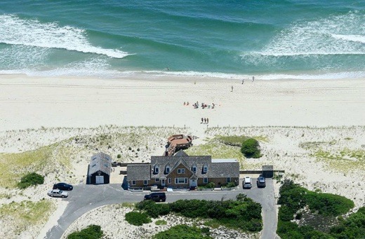
Image above: Aerial photo of Island Beach State Park in New Jersey where Governor Chis Christie took wife, family and security detail for some fun in the sun after he closed public and state parks on Monday of this Fourth of July weekend. Photo by Andrew Mills. From original article.

[IB Publisher's note: This is the end of Chris Christie's career. First he was fired by Trump and now this pathetic self inflicted wound.]

Talk about your profanely perfect metaphor: This hot and sunny weekend, big-time New Jersey cretin and governor Chris Christie closed down the state's parks and beaches due to a budget stalemate.

Then he hopped into his State Police helicopter and took his entire family to the 10-mile, now blissfully pristine Island Beach State Park, which thanks to the closing they had to themselves.

All day, meanwhile, police posted at the park's gates turned away the hot and frustrated peasants who pay Christie's salary as a, lest we forget, so-called public servant. Later, the family and their friends hunkered down in the palatial residence provided there by - yes! - also us.

Asked about it at a press conference later in the day, Christie - who boasts a 15% approval rating, or the lowest of any governor in the country - first lied that he hadn't gotten any sun that day. When confronted by photos from an enterprising photojournalist, his spokesman conceded “the governor was on the beach briefly” but "he had a baseball hat on.” 

Because one middle finger to his public wasn't enough, Christie added another when asked if this was fair: “That’s just the way it goes,” he said. “Run for governor and you can have a residence there.”  

Welcome to the class war, where Christie and the big orange creep and their entitled ilk have no more fucks to give as long as they can get away with it. Soon, let them eat sand.


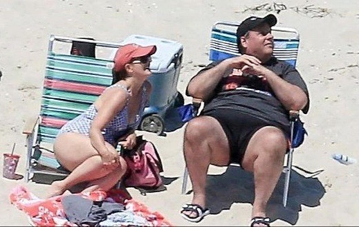
Image above: Video still of NJ Governor Chis Christie with wife watching the press helicopters capturing his "private" beach jaunt. Taken by Andrew Mills. From (http://abcnews.go.com/GMA/video/gov-chris-christie-unapologetic-beach-photos-48431133).

.

MV-22 Osprey landing at Salt Pond

SUBHEAD: Multiple landings and takeoffs of controversial aircraft at Kauai public beach.

By Juan Wilson on 5 February 2017 for Island Breath -
(http://islandbreath.blogspot.com/2017/02/mv-22-oprey-landings-at-salt-pond.html)


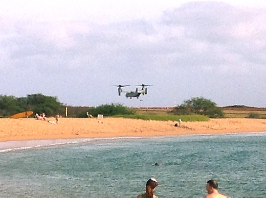
Image above: Photo for this article by Juan Wilson of Osprey aircraft landing over Salt Pond Beach Park.

Last Tuesday, January 31st, I was at the beach with my wife Linda and granddaughter Ruby. We were at the kiddy beach at the west end of Salt Pond Park in Hanapepe, Kauai, Hawaii. It was a pleasant sunny day and there were several locals and tourists on the beach and in the water.

At four-thirty in the afternoon a deep guttural growl could be heard coming from the east. In moments the sound amped up as a strange looking "plane" flew past going west offshore of the southern extremity of nearby Puolo Point. The profile was that of uniquely odd MV-22 Osprey helicopter/plane that was developed primarily for the US Marine Corps.

The Osprey has rotational wings that old two turbine propeller engines that allow it to fly much faster than a conventional helicopter yet rotate its engines and land vertically.

"The best of both world's?" Not exactly! I knew from previous reporting that the Marine Corps had been having performance issues with the Osprey.

It was found that the Osprey is quite sensititve to dust entering its turbine engines when landing in sandy and dusty conditions. It has experienced crashes. Hovering for even a short while over dusty terrain had to be severely limited.

I had hard that the military had plans to do training for the Ospreys on Kauaiand be stationed out of the Pacific Missile Range Facility (PMRF). I heard it involved difficult landings and takeoffs from narrow valleys on the Napali Coast. I assumed the passing Osprey was on its way west to land at the PMRF for that training.

But once shortly just past Kamakani near the old Gay & Robinson sugar mill the Osprey could be seen turning around. It approached Salt Pond Beach low and fast. As it past the sound of the rotors was quite load. The Osprey passed right over swimmers and people on the beach and slowed as it came to the runway near Puolo Point.

That's when the thing got really noisy. As it rotated its wings to vertical orientation it ceased traveling horizontal and the engines whined loudly. There must be some strange dynamic between the horizontal and vertical flight that causes chaotic and disturbing vibrations boomed across the water to where I stood a half a mile away. It sounded like a controlled crash.

The Osprey never shut down its engines after landing. In a moment it revved up the turbines and began a vertical take-off. Again chaotic and noisy at it made it transition to horizontal flight. Some people did not understand what was going on and seemed disturbed.

The Osprey took off going east and somewhere over Hanapepe Sound came around to west again and past again heading towards Kamakane. Once there it did a one-eighty and returned to land again. It seemed a little closer to where I stood in the kiddy pond.By this time I was shaking my fist at the Osprey.

Altogether there were three test landings over the public beach.

A a resident of Hanapepe, and a frequent user of Salt Pond Beach Park, I strongly request that the US military use its own 10,000 foot runways at the PMRF for this training activity and stay away from public recreational areas with this controversial aircraft.

The Japanese on Okinawa have had a long struggle with the US Marines and their Ospreys. This Janaury 9th there was a non-fatal crash of an Osprey in Okinawa that brought safety fears to the fore. See (http://www.japantimes.co.jp/news/2017/01/09/reference/nonfatal-osprey-crash-okinawa-brings-safety-fears-fore/#.WJe8rRAnr6g).

Closer to home their has been a crash on Oahu.

After relating this encounter with the Marines to a friend he identified a valley on the Napali Coast where if one hikes these days you will be met with camouflaged armed soldiers coming from hidden structures who will frog-walk you out of the valley.


Visdeo above: Osprey aircraft takes of after passing over Salt Pond Beach Park and landing on tarmac of runaway near Puolo Point near Hanapepe, Kauai, on 31 January 2017. Filmed by Juan Wilson.  From (https://youtu.be/j6eAKPpbun8).


Image above: Two days before this landing on Kauai an Osprey crashed in burned in Yemen during the ill-fated Al Qaeda raid by Seal Team Six. From (https://theaviationist.com/2017/01/29/u-s-mv-22-osprey-tilt-rotor-aircraft-crash-lands-in-yemen-during-special-ops-raid-on-al-qaeda/).

See also:
Ea O Ka Aina: Kauai and Niihau endangered 9/24/16
Ea O Ka Aina: Oceans 4 Peace Pacific Pivot Panel 6/18/16
Ea O Ka Aina: Judgement against RIMPAC 2016 5/29/16
Ea O Ka Aina: Okinawans wish US military gone 8/26/15
Ea O Ka Aina: RIMPAC 2014 in Full March 7/17/14
Ea O Ka Aina: Stop bombing Kaula Island! 10/8/12
Ea O Ka Aina: Marines backing off 8/24/12
Ea O Ka Aina: Unproved Osprey on Kauai 8/21/12


EPA vs Pflueger and other violators

SOURCE:  Michael Guard Sheehan (mailto:hanaleirivermichael@gmail.com)
SUBHEAD: EPA closes Pflueger case on Kauai but ignores other owner's environmental violations.

By Dean Higuchi on 24 August 2016 for the EPA.gov -
(https://www.epa.gov/newsreleases/epa-closes-pflueger-stormwater-case-after-successful-restoration-kauai-property)


Image above: This photo from 2004 was taken prior to environmental damage caused by this unauthorized grading and landscaping by retired car dealer James Pflueger on his Pila’a property. From (http://www.staradvertiser.com/breaking-news/pfluegers-environmental-repairs-on-kauai-shoreline-meets-epa-muster/).

Editorial comment  by Michael Guard Sheehan:
This case is a tragic case of selective enforcement against one man while surrounding him were numerous persons and politicians doing far worse to the Environment with their own illegal digging and construction in Habitats for Endangered Species. Instead of self-congratulatory news releases, your organization should be shamefully quiet and reflective.

The U.S. Environmental Protection Agency announced the successful conclusion of its case against James Pflueger for construction activities that damaged his former property and the beach and coral reefs at Pila’a on Kauai. The consent decree settling the Clean Water Act violations was closed after Pflueger stabilized and restored the slopes and streams.

“Thanks to the work completed under this settlement, this once-degraded land has a healthy population of native trees and shrubs and restored stream channels,” said Alexis Strauss, EPA’s Acting Regional Administrator for the Pacific Southwest. “With continued care by the new owners, these restoration efforts can be sustained for the future.”

EPA initiated its case after Pflueger conducted extensive grading and construction at the 378-acre coastal site without obtaining necessary Clean Water Act permits. Those activities included excavating a hillside to expose a 40-foot vertical road cut, grading a coastal plateau, creating new access roads to the coast, and dumping dirt and rock into three perennial streams. As a result, massive discharges of sediment-laden stormwater flowed to the ocean at Pila’a Bay in November 2001.

The settlement required Pflueger to build a wall to stabilize the road cut adjacent to the shoreline, remove dam material in streams, install erosion controls on roadways and trails, terrace slopes to slow runoff, use native plants to control erosion, and control invasive plants and animals on the property. He was also required to reconstruct natural rock-lined stream beds and reestablish native plants along the banks.

The 2006 stormwater settlement was the largest for federal Clean Water Act violations at a single site, by a single landowner, in the United States. Pflueger paid $2 million in penalties to the State of Hawaii and the United States, and was expected to spend approximately $5.3 million to conduct the required restoration efforts.

The State of Hawaii was a co-plaintiff in EPA’s case against Pflueger, and the settlement was joined by the Limu Coalition and Kilauea neighborhood organizations, which had also filed a lawsuit against Pflueger.

EPA and local community organizations involved in the settlement conducted oversight inspections throughout a ten-year restoration effort that was slowed by funding obstacles and the necessity of adapting the restoration projects to changing field conditions.

.

Zuckerberg's idea of Kuleana

SUBHEAD: Facebook's Mark Zuckerberg buying 700 acres of Kauai north shore.


[IB Publisher's note: This correction from Richard Spacer:
"On the Zuckerburg article, you made the same mistake Andy Parx did.

The Zuckerburg purchases have nothing at all to do with Lepeuli. Lepeuli is the ahupua'a that Lepeuli Beach aka Larsen's Beach is in. The land owner is, and remains, Waioli Corporation, a public charity governed by a board of trustees with Wilcox family members and friends.

Waipake makai of Koolau Road was bought by Zuckerburg from Falko Partners, owned by San Mateo hedge fund owner Larry Bowman. That beach is Waipake Beach.

Pila'a makai was bought by Zuckerburg from Jimmy Pflueger. There are two beaches in Pila'a.

None of this has any connection with Lepeuli. Even the photo caption mention Lepeuli when the photo is of Waipake Beach. Thanks."
The illustrations and description relating purchase to Lepeuli has been removed. Mahalo Richard.


By Erin Carlyle on 10 October 2014 for Forbes Magazine -
(http://www.forbes.com/sites/erincarlyle/2014/10/11/confirmed-facebooks-mark-zuckerberg-paying-more-than-100-million-for-kauai-property/)


Image above: Mark Zuckerberg and his wife, Priscilla Chan, (center) walk in Hanalei after lunching at Bubba Burgers on a vacation this spring. From (http://www.nydailynews.com/news/national/mark-zuckerberg-priscilla-chan-low-key-hawaii-vacation-article-1.1326290).

Facebook’s Mark Zuckerberg has purchased two massive, adjacent chunks of land on Kauai’s North Shore in an effort to create a secluded 700-acre sanctuary for his family, sources have confirmed to Forbes. All told, the 30-year-old billionaire has spent in excess of $100 million to acquire the land, and he hasn’t even built a house yet.

The first acquisition is Pila’a Beach, an isolated, 393-acre parcel with a gorgeous white sand beach. Property records show that an entity called Pila’a International LLC paid $49.8 million for an 89.2% stake (or about 350 acres) in the property on September 12. Pila’a International, LLC has an office in Woodbridge, Conn. The property was not officially listed, but was being shopped discreetly as a “pocket listing.”

Zuckerberg’s second acquisition is the adjacent Kahu’aina Plantation, a 357-acre former sugarcane plantation that has been off-and-on-the market for a few years, most recently listed for $70 million. That property features 2,500 feet of oceanfront and a working organic farm. The sale price has not yet been recorded at the county, but local reporter Duane Shimogawa of Pacific Business News pegs it at about $66 million. Sources tell Forbes his reporting is accurate.

Though the Facebook billionaire brought an unusually lengthy non-disclosure agreement along on his property shopping trip, the fact that he bought land on Kauai’s North Shore is a well-known secret on the island. Last year, when Zuckerberg dined at burger joint Bubba Burgers he made the local paper’s front page.

“We don’t comment on rumors and speculation, but thank you for reaching out!” a Facebook spokesperson said.

Zuckerberg purchased Pila’a Beach from Pflueger Properties, a Hawaii limited partnership belonging to Jim Pflueger, a retired local Honda dealer. Last year Pflueger reportedly pled no contest to felony reckless endangerment after seven people were killed in a 2006 collapse of a dam on his property.
The Pila’a Beach property consists of five separate parcels, each which could be developed into private homes.

Sources tell Forbes that Zuckerberg plans to build just one home on the parcels. But he will have one neighbor, Denver executive Gary Stewart of Melange International, who purchased the remaining 10.8% interest in the property for $6.04 million under the name Koa Kea International LLC, according to property records. Sources tell Forbes that the billionaire tried to buy Stewart out, but that the oil exec wasn’t interested. Stewart did not respond immediately to Forbes’ inquiry about the property.

But the 30-year-old tech executive is having better luck buying out what a source says are as many as two dozen “kuleanas,” or small plots of landlocked land within the greater 357 acres that is Kahu’aina Plantation.

Kuleanas are plots of land that often house basic, even ramshackle huts, many without electricity, which have been passed down through families over generations. They are generally used as rustic weekend or vacation spots, although some people live on them full-time. Zuckerberg is said to be paying large sums for these tiny plots of land, so that his compound can be totally private.

The Kahu’aina Plantation had been approved for up to 80 homes, so Zuckerberg’s buy seems designed to fend off potential neighbors. The seller of the plantation is San Mateo, Calif.-based Falko Partners, which is reportedly owned by a Hawaii landowner named Larry Bowman.
Zuckerberg has a net worth of $32.2 billion at the time of this story.

Corrections and amplifications:
The original article implied that “kuleanas” were the residences on landlocked plots of land within a bigger parcel. “Kuleanas” actually refers to the land rights themselves. Also, a beach was referred to as “private”; Hawaii has no beaches that are not open to the public.

See also:

Ea O Ka Aina: Larry Ellison - Oracle 6/21/12
Oracle Corporation's CEO buys Lanai from Castle & Cook's David Murdoch for half a billion dollars. Too bad Bill Gates and mark Zuckerberg - you missed out.

Ea O Ka Aina: Trails and Tribulations 2/26/13
For centuries Native Hawaiians in the ahupua'a of Lepeuli, on the windward or Koolau side of Kauai, have lived their lives, fished and grew taro ...

Ea O Ka Aina: The Ala Loa Trail 4/10/14
Lepeuli Beach from the Ala Loa Trail on Kauai's Koolau northshore.


.

North Shore Toxic Sediment

SUBHEAD: Sediment tests off Hanalei and Anini Beach reveal toxic metals and organic compounds.

By Michael Guard Sheehan on 11 January 2014 in Island Breath -
(http://islandbreath.blogspot.com/2014/01/hanalei-river-toxic-sediment.html)
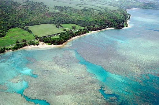

Image above: Aerial photo of Anini Beach looking northwest towards Hanalei. From (http://www.hawaiigaga.com/kauai/beaches/anini-beach.aspx).

The following report is the result of testing sediment samples taken in November of 2013. Reasd it and weep.

REPORT TO:   
Hanalei River Heritage Foundation
Post Office Box 518            
Hanalei, HI 96714

REPORT OF:     
Significant Findings Report- Review of Test America Report ID 320-4779-1
10 Sediment Samples- Near Kauai North Shore, Hanalei Bay, and Anini Bay, Hawaii
Sampled on Nov. 12 and 13, 2013
                                          
JOB NUMBER:   
14-3306

ATTENTION:
Mr. Michael Guard Sheehan
hanaleirivermichael@gmail.com
                                                       
Analytical Chemical Testing Laboratory, Inc’s (ACT) Analytical Chemist, Mr. Robert M. Naman, has reviewed Test America’s Report ID# 320-4779-1  presented to the Hanalei River Heritage Foundation on the results of analysis of 10 sediment samples from specific locations near Hanalei Bay and Anini Bay, Hawaii.

All aspects of the reported data were reviewed including Organic Semi-Volatiles; Herbicides; Dioxins; Furans; Organo-chlorine Pesticides; Organo-Phosphorus Pesticides; and Heavy Metals.  Also reviewed was a report by North Coast Laboratories, Ltd. of  Arcata, CA, for Glyphosate  in each of the sediment samples from Hanalei Bay, Hawaii.

The information presented herein is the Significant Findings with respect to ACT’s review of the supplied report.  Our Significant Findings are as follows: 

SAMPLE SEDIMENT LOCATIONS   
 1  Hanalei Bay 1
 2  Hanalei Bay 2
 3  Anini Bay 1
 4  Anini Bay 2
 5  Sealodge Reef 1
 6  Sealodge Reef 2
 7  Hanalei River 1
 8  Hanalei River 2
 9  Anini Creek 1
10 Anini Creek 2

SIGNIFICANT FINDINGS
Organic Semi-Volatile Compounds showed no detection of Method listed compounds in any of the 10 samples submitted.  However, Tentatively Identified Organic Compounds were detected and estimated in each analysis.  The findings are:

SAMPLE LOCATIONS      ESTIMATED ORGANIC COMPOUNDS


 1  Hanalei Bay 1                    Benzaldehyde 270 ug/Kg; Bicyclo undec-4-ene 470 ug/Kg;
                                               1H-Cycloprop-azulene 430 ug/kg;
                                               Approximately 12,000 ug/Kg of Unknown Alkanes, Organic Acids,
                                               And Unknown Organic Compounds

 2  Hanalei Bay 2                   Benzaldehyde 220 ug/Kg; Bicyclo undec-4-ene 430 ug/Kg;
                                               Approximately 5,000 ug/Kg of Unknown Alkanes, Organic Acids,
                                               And Unknown Organic Compounds

 3  Anini Bay 1                      Approximately 2,200 ug/Kg of Unknown Organic Acids,
                                               And Unknown Organic Compounds

 4  Anini Bay 2                      Approximately 1,300 ug/Kg of Unknown Organic Acids,
                                               And Unknown Organic Compounds

 5  Sealodge Reef 1               Approximately 22,000 ug/Kg of Unknown Organic Compounds

 6  Sealodge Reef 2               Approximately 10,500 ug/Kg of Unknown Organic Compounds

 7  Hanalei River 1                 Approximately 8,000 ug/Kg of Unknown Organic Compounds

 8  Hanalei River 2                 Bicyclo undec-4-ene 360 ug/Kg;
                                               Approximately 7,500 ug/Kg of Unknown Alkanes And Unknown                                                          Organic Compounds

 9  Anini Creek 1                    Approximately 1,000 ug/Kg of Unknown Organic Compounds

10 Anini Creek 2                    Approximately 1,300 ug/Kg of Unknown Organic Compounds


TEST GROUP                             RESULTS OF TESTING
Herbicides                                      Not Detected in significant levels in any of the 10 samples

Dioxins & Furans                   Not Detected in any of the 10 samples

Organo-Chlorine Pesticides           Trace Levels reported present in all 10 samples but
                                                        present in insignificant amounts and not verified   

Organo-Phosphorus Pesticides       Not Detected in any of the 10 samples

Glyphosate                                     Not Detected in any of the 10 samples


ORGANIC COMPONENTS SIGNIFICANT FINDINGS SUMMARY
In summary, there exists a substantial amount of unknown organic compounds that are present in these sediments as Tentatively Identified Compounds (TIC).  The significance of these organic compounds has not been established, but some are cyclic and others are straight chain Alkanes and unknown Organic Acids.
\
No research exists for these unknown compounds and therefore causes much speculation considering that most of the sediments contain between 5,000 and 22,000 ug/Kg of these TIC components.  At these levels a great concern exists for the marine life subjected to these compounds and any persons consuming  these compounds may be affected in ways that are yet to be understood.

Human health and the environment must coexist in a symbiotic harmony that does not allow for the potential impact presented here and the unknown affects that the presence of these compounds could have on human health and proper organ function.


HEAVY METALS                              
SAMPLE SEDIMENT LOCATIONS       RESULTS OF TESTING

    1    Hanalei Bay 1                                      Significant Level of Arsenic         18 mg/Kg
                                                                  Significant Level of Chromium  130 mg/Kg
                         Significant Level of Nickel        150 mg/Kg
                         Significant Level of Cadmium  0.99 mg/Kg
                         Significant Level of Cobalt          23 mg/Kg
                         Significant Level of Copper         26 mg/Kg
                         Significant Level of Selenium   0.92 mg/Kg
                         Significant Level of Vanadium    80 mg/Kg

    1    Hanalei Bay 2                                      Significant Level of Arsenic         16 mg/Kg
                         Significant Level of Chromium  100 mg/Kg
                                                                  Significant Level of Nickel        130 mg/Kg
                         Significant Level of Cadmium  0.74 mg/Kg
                         Significant Level of Cobalt          19 mg/Kg
                         Significant Level of Copper         20 mg/Kg
                         Significant Level of Selenium   0.65 mg/Kg
                         Significant Level of Vanadium    61 mg/Kg

    1    Anini Bay 1                                          Significant Level of Arsenic        9.8 mg/Kg
                         Significant Level of Chromium    44 mg/Kg
                                                                  Significant Level of Nickel          18 mg/Kg
                         Significant Level of Cadmium  0.34 mg/Kg
                         Significant Level of Cobalt          4.7 mg/Kg
                         Significant Level of Copper         5.1 mg/Kg
                         Significant Level of Selenium    0.73 mg/Kg
                         Significant Level of Vanadium    45 mg/Kg

    1    Anini Bay 2                                         Significant Level of Arsenic         12 mg/Kg
                         Significant Level of Chromium    43 mg/Kg
                                                                  Significant Level of Nickel           28 mg/Kg
                         Significant Level of Cobalt          1.8 mg/Kg
                         Significant Level of Copper         5.2 mg/Kg
                         Significant Level of Selenium      1.8 mg/Kg
                         Significant Level of Vanadium     41 mg/K

    1    Sealodge Reef 1                                  Significant Level of Arsenic        3.0 mg/Kg
                         Significant Level of Chromium    15 mg/Kg
                                                                  Significant Level of Nickel          1.4 mg/Kg
                         Significant Level of Cobalt          1.8 mg/Kg
                         Significant Level of Selenium      1.4 mg/Kg
                         Significant Level of Vanadium    6.5 mg/Kg

    1    Sealodge Reef 2                                  Significant Level of Arsenic        2.0 mg/Kg
                         Significant Level of Chromium    12 mg/Kg
                                                                  Significant Level of Nickel          8.2 mg/Kg
                         Significant Level of Cobalt          1.4 mg/Kg
                         Significant Level of Selenium    0.58 mg/Kg
                         Significant Level of Vanadium    4.8 mg/Kg

    1    Hanalei River 1                                    Significant Level of Arsenic          14 mg/Kg
                         Significant Level of Chromium   160 mg/Kg
                                                                  Significant Level of Nickel          480 mg/Kg
                         Significant Level of Cadmium      1.2 mg/Kg
                         Significant Level of Cobalt            55 mg/Kg
                         Significant Level of Copper           39 mg/Kg
                         Significant Level of Vanadium      77 mg/Kg

    1    Hanalei River 2               Significant Level of Arsenic            15 mg/Kg
                         Significant Level of Chromium     180 mg/Kg
                                                                  Significant Level of Nickel           530 mg/Kg
                         Significant Level of Cadmium       1.2 mg/Kg
                         Significant Level of Cobalt             61 mg/Kg
                         Significant Level of Copper            43 mg/Kg
                         Significant Level of Selenium      0.99 mg/Kg
                         Significant Level of Vanadium       88 mg/Kg

    1    Anini Creek 1                                      Significant Level of Arsenic            32 mg/Kg
                         Significant Level of Chromium     180 mg/Kg
                                                                  Significant Level of Nickel             18 mg/Kg
                         Significant Level of Cobalt             20 mg/Kg
                         Significant Level of Selenium        1.8 mg/Kg
                         Significant Level of Vanadium       25 mg/Kg
     
10     Anini Creek 2                          Significant Level of Arsenic          9.1 mg/Kg
                         Significant Level of Chromium       39 mg/Kg
                                                                  Significant Level of Nickel             21 mg/Kg
                         Significant Level of Cadmium     0.37 mg/Kg
                         Significant Level of Cobalt            4.4 mg/Kg
                         Significant Level of Selenium        1.5 mg/Kg
                         Significant Level of Vanadium       32 mg/Kg

mg/Kg = milligrams per Kilogram = Parts per Million


HEAVY METALS RESULTS DISCUSSION
Results show elevated concentrations of Arsenic in every sample tested, ranging from 2.1 mg/Kg to 18 mg/Kg, or p.p.m.  At these elevated levels, Arsenic uptake into oysters, mollusks, crabs, bivalves, and bottom dwellers and feeders allows for ingestion by humans consuming these marine organisms.

Arsenic is a poison and an EPA Listed Hazardous Metal that can deleteriously affect the life cycle and impair normal functions of these marine life.  When allowed to enter into the food chain, humans consuming these marine life can also be affected by Arsenic’s presence.   It is also likely that coral reefs could be seriously affected by the Arsenic presence in these samples at the levels reported in the sediments.

The US EPA regulates leachable Arsenic from sediments and lists the Hazardous Leachable level (TCLP) of Arsenic as 5.0 mg/L, or p.p.m.

Results show elevated concentrations of Cadmium in 6 of 10 samples tested, ranging from 0.34 mg/Kg to 1.2 mg/Kg, or p.p.m.  At these elevated levels, Cadmium uptake into marine life would likely be a concern from ingestion by humans consuming these marine organisms.

Cadmium is an EPA Listed Hazardous Metal that can also affect the life cycle and impair normal functions of marine life.  When allowed to enter into the food chain, humans consuming these marine life can also be affected by Cadmium’s presence.   It is also likely that coral reefs could be seriously affected by the Cadmium presence in these samples at the levels reported in the sediments.

The US EPA regulates leachable Cadmium from sediments and lists the Hazardous Leachable level (TCLP) of Cadmium as 1.0 mg/L, or p.p.m.
                                               
Results show elevated concentrations of Chromium  in every sample tested, ranging from 12 mg/Kg to 160 mg/Kg, or p.p.m.  At these elevated levels, Chromium uptake into marine life allows for ingestion by humans consuming these marine organisms.

Chromium is a poison and a carcinogen, and is an EPA Listed Hazardous Metal that can deleteriously affect the life cycle and impair normal functions of marine life.  It can affect normal protein synthesis in healthy organisms and when allowed to enter into the food chain, humans consuming these marine life can also be affected by Chromium’s presence.   It is also likely that coral reefs could be seriously affected by the Chromium presence in these samples at the levels reported in the sediments.

The US EPA regulates leachable Chromium from sediments and lists the Hazardous Leachable level (TCLP) of Chromium as 5.0 mg/L, or p.p.m.

Results show elevated concentrations of Cobalt in every sample tested, ranging from 1.4 mg/Kg to 60 mg/Kg, or p.p.m.  Cobalt can also be radioactive and can remain in sediments for long periods of time.  At these elevated levels, Cobalt uptake into marine life would likely be a concern from ingestion by humans consuming these marine organisms.  When allowed to enter into the food chain, humans consuming these marine life can also be affected by Cobalt’s presence.   It is also likely that coral reefs could be seriously affected by the Cobalt presence in these samples at the levels reported in the sediments. 

Results show elevated concentrations of Nickel  in every sample tested, ranging from 8.2 mg/Kg to 530 mg/Kg, or p.p.m.  Nickel uptake into marine life would also likely be a concern from ingestion by humans consuming these marine organisms.  It is also likely that coral reefs could be seriously affected by these levels of Nickel reported in the sediments analyzed. 

Results show elevated concentrations of Selenium in 9 of 10 samples tested, ranging from 0.58 mg/Kg to 1.8 mg/Kg, or p.p.m.  At these elevated levels, Selenium uptake into marine life would likely be a concern from ingestion by humans consuming these marine organisms.  Selenium is an EPA Listed Hazardous Metal that can also affect the life cycle and impair normal functions of marine life.

When allowed to enter into the food chain, humans consuming these marine life can also be affected by Selenium’s presence.   It is also likely that coral reefs could be seriously affected by the Selenium presence in these samples at the levels reported in the sediments.   The US EPA regulates leachable Selenium from sediments and lists the Hazardous Leachable level (TCLP) of Selenium as 1.0 mg/L, or p.p.m.

Results show elevated levels of Vanadium present in every sample  tested, ranging from 4.8 mg/Kg to 88 mg/Kg, or p.p.m.  At these elevated levels, Vanadium uptake into marine life would likely be a concern from ingestion by humans consuming these marine organisms.  When allowed to enter into the food chain, humans consuming these marine life can also be affected by Vanadium’s presence.   It is also likely that coral reefs could be seriously affected by the Vanadium presence in these samples at the levels reported in the sediments.  

Results show elevated levels of other metals including Zinc which was present in every sample  tested, ranging from 2.2 mg/Kg to 82 mg/Kg, or p.p.m.  Zinc uptake into marine life could also be a concern from ingestion by humans consuming these marine organisms.  It is also likely that coral reefs could be seriously affected by the Zinc presence in these samples at the levels reported in the sediments.

Heavy Metals contamination in general can have a serious adverse impact on the normal life cycle and function of marine life.  Because of the large variety of metals detected in these samples, the metals present and the combined levels detected in the sediments would likely be a strong contributor to the demise of the coral reefs in the areas in question.


FINAL SUMMARY
rganic Compounds present when coupled with Heavy Metals can affect internal organs of all organisms and are a clear danger to human health and the marine environment.   Normal life cycles and development in marine life can be disrupted from the presence of the compounds detected in this report and will generate concerns that cannot go unnoticed.

The results produced by this report only point to a need for further testing and research with target organisms to develop a better understanding of the long-term impacts of the presence of these substances.

The real danger which has not been discussed here is the affect these substances have on microscopic organisms which can be greatly affected by changes in the aquatic matrix in which all marine life thrives.  These concerns should also be researched and studied to attain a better understanding of what measures may be able to be utilized to minimize the impact presented by the results discovered in this report.  Water column analysis would likely need to be addressed as well to get a better picture of the degree and presence of dissolved compounds and contaminants that are present.

A serious attempt should also be made to determine the source of these compounds in these sediments so that further impact can be prohibited.   Scientific methods and models should be developed to gain understanding and real insight for future human impact on marine environments and human health.  

The information presented here constitutes the professional opinions of the undersigned, as relates to this report and the data generated by it.

We appreciate this opportunity to be of service.  If there are any questions, please feel free to call.

                    Very truly yours,

                    ANALYTICAL CHEMICAL TESTING LABORATORY, INC.
                     
                    Robert M. Naman, President
                    Analytical Chemist
                    Fellow, American Institute
                    of Chemists, Reg. 15488


.

Photo of the Day

SUBHEAD:  The Photo of the Day on TreeHugger.com is a rainbow as it falls over Kauai at sunset.

By Jaymi Heinbuch on 23 August 2013 for TreeHugger -
(http://www.treehugger.com/slideshows/natural-sciences/photo-day-rainbow-falls-over-kauai-sunset/)


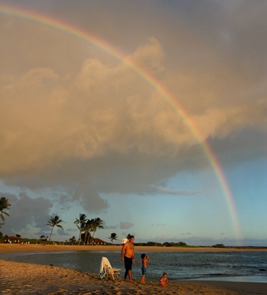
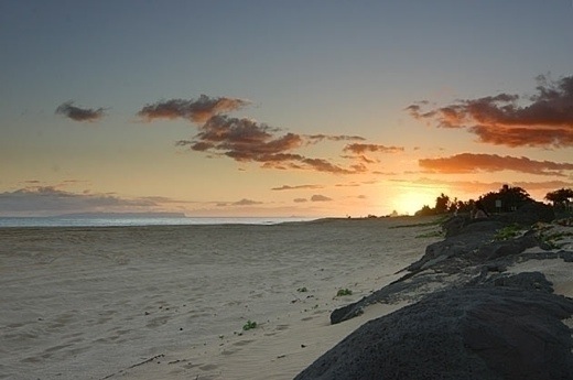
Image above: Photo of Salt Pond Beach Park by Jaymi Heinbuch.

A tropical paradise isn't complete without a rainbow at sunset. During a break in a shower, a rainbow appears as a family plays at the water's edge.


Bozos out of touch at HI DOT

By Juan Wilson on 23 August 2013 for Island Breath - 
(http://islandbreath.blogspot.com/2013/08/photo-of-day.html)

This photo above was featured today at the top of the popular website TreeHugger.com. The unattributed Kauai slocation above is taken from the area of the keiki beach at Salt Pond Beach Park in Hanapepe looking southeast. In the left-background is the location of Hawaiian salt gathering for the last 1,000 years. In the right-backgound is Puolo Point and a small airstrip.

Puolo Point is about 60 acres of  grassland and windswept haole koa trees. It is a bird sanctuary with a magnificent view of much of the south and west sides of Kauai. Pueo owl s are frequently seen hunting at sunset.


Image above: Photo of "No Trespassing" recently erected on othe alaloa path at Puolo Point. Click to see panoramic view.

In the last few weeks the Hawaii Department of Transportation Divisions of Airports have put up "No Trespassing No Camping" signs. Whoever put the signs up had the gall to set them outside the airport area and along shore in the traditional Hawaiian alaloa (belt trail around the island). These paths are the traditional route of Hawaiians and especially fishermen. The alaloa are not to be tampered with by foreign occupiers. Screw the DOT and the airport!

I can only imagine that this new directive by the DOT comes from fearfulness. Either it comes from the scaredy-cats at the US Department of Homeland Security, or it's an excuse to roust the occasional "scary homeless" person from camping in a place, off the road, where they can get some sleep. 

I would rather have the current airport operations pack-up and go and leave the place to the birds and local people. Most operations within the DOT fence are tourist thrill rides including ultra-lights, parachuting and helicopter rides by an outfit that doubles up on income by flying "green harvest " runs and "special ops" for the Navy, DEA and KPD as well as ratting out hikers on the westside to Keith Robinson.


Image above: A photo from Puolo Point at sunrise titled "Fire, Air, Earth, Water" by Arius Hopman, of Hanapepe, Kauai, illustrating this article we posted trying to protect the area from further development. To see more of Arius' work start here (http://www.hopmanart.com/artwork_detail.php?products_id=55&278163f320da9a5285220a73).


.

Trails and Tribulations

SUBHEAD: The location of the fence is subject to approval by the DLNR to ensure public access to and along the lateral coastal trail.

By Richard Spacer on 25 February 2013 Hawaii Reporter -
(http://www.hawaiireporter.com/lepeuli-kauai-trails-and-tribulations/123)


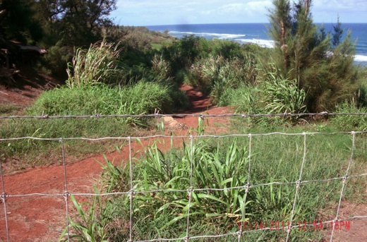
Image above: Photo of illegal cattle fence with barbwire blocking access to Lepeuli Beach. From original article.

For centuries Native Hawaiians in the ahupua'a of Lepeuli, on the windward or Koolau side of Kauai, have lived their lives, fished and grew taro from the streams there as noted by early missionarys and sailors. They walked from their settlements in Lepeuli to other Kauai ahupua'a along the ala loa trail, a lateral, coastal trail that runs along near the sea.

Long before the idea of the H-1 in Honolulu, or Kuhio Highway on Kauai, Hawaiians of old used THEIR highway system, the trails, to get from A to B. They were public infrastructure, no less so than any street or highway today.

The Hawaiian cultural concepts of sharing and general lack of private ownership was no threat to these trails being open and accessible. Not so today.

The arrival of Captain Cook and the cataclysmic transformation of society in Hawaii that followed, squelched not only traditional cultural practices like speaking their Hawaiian language, dancing the hula, and surfing, but public access.

The introduction of the European and American concept of private property to Hawaii, especially when Kamehameha III initiated private land ownership to Hawaiians in 1848 and to all comers in 1850, was intended in principle to economically empower the local population. That, in fact, it has greatly benefited non-Hawaiian interests was no small reason Queen Lili' uokalani, in the last year of her legislature in 1892, passed the Highways Act. It is incorporated now as Hawaii Revised Statutes 264-1, in other words, the law of the land today.

This brilliant, forward thinking act is used today, but not often enough, as a powerful tool to acquire public trail access.

Fast forward to 2009 at Lepeuli, Kauai where a cattle rancher named Bruce Laymon applies for state and county permits for his beef cattle ranch company called Paradise Ranch. Laymon, beneficiary of a highly questionable Hawaii sweetheart deal system known as "after-the- fact" permitting, applied for these permits after the public informed land regulators that he was clearing brush mauka of the public beach there without a permit. The beach, commonly known as Larsen's Beach, is a healthy breeding ground to federally endangered Hawaiian Monk Seals and green sea turtles. Above, Laysan Albatross fly in winter.

The beach never really gets busy, 20 people all day is typical. Two dangerous rip currents, cuts in the reef by old streams, which are now intermittant, have taken at least 13 lives there. The reef offshore is pristine, and fishing is a favorite pastime. The property to which Laymon has an exclusive lease is 541 acres in size owned by Waioli Corporation, a non-profit public charity. It was purchased by Abner Wilcox, a missionary teacher, from Kamehameha III in 1850.

Laymon has an air of entitlement to the property. In March of 2010, while clearing vegetation with a brush hog in violation of his permit, Laymon told beachgoers he was going to run the f-----g haoles out of there.

How is someone going to RUN the public off a public beach? That is invasion of privacy, harrassment, and terroristic threatening. Those are all crimes for which the perpetrator can and should be arrested. It is also hate speech, stating he will run out an entire class of persons based on their race. A complaint was made to the FBI, the Kauai Police, and the former Kauai Prosecuting Attorney. No arrests were made.

When Laymon applied for his after-the-fact permits, he denied the existence of the animals named above, and denied archaeology was on the property. Community members noticed an archaeological feature at the northwest end of the beach and reported it to the State Historic Preservation Division of DLNR. Nancy McMahon, at the time the Deputy State Historic Preservation Officer, replied that it was the site of three human burials. There are three burials on the property, but they are at the opposite end a half mile from the archaeology.

The exact location of the burials is unknown, except that McMahon said they were re-interred mauka of where they were discovered, which would put them inside an area where cattle were planned to graze. Dr. David Burney of the National Tropical Botanical Institute on Kauai, identified the feature as likely the foundation of a structure, radiocarbon dated from just before the arrival of Europeans.

Laymon's permit applications also denied any Native Hawaiians lived on, or had claims to the property since 1850, when Abner Wilcox purchased it. A letter of Abner Wilcox on file with the Kauai Historical Society from 1864 states.. .."the natives have the good of the land." meaning it did not bother Abner if they lived there. Later maps into the 1930's show multiple kuleana lots in Lepeuli.

Lepeuli had a Hawaiian school and church, establishment of which was part of the deal for Abner Wilcox to receive the land. An 1850 survey map at the State Archives shows the school and church location. The residents of Lepeuli studied and prayed at that school and church well into the Twentieth Century. Generations of Hawaiians are buried in the grave yard there. The 1963 John Wayne movie Donovan's Reef depicts the old school and church.

The most contentious part of Laymon's permit applications was his intent to fence off the lateral, coastal trail at Lepeuli, that many believe is an ancient, historic, ala loa trail. This trail runs from ahupua'a to ahupua'a parallel to the shore. It is clearly depicted on 1833 and 1878 Registered Maps on file with the State Surveyor. Laymon, his attorney, and landowner Waioli Corporation dismiss the existence of the trail on their property.

Laymon's state Conservation District Use Permit allowed him to fence 110 feet mauka of the shoreline, inside the state Conservation District regulated by DLNR. The State of Hawaii claims a trail in fee simple in Lepeuli and this is stated in letters from 2000, 2011, and 2012. The 2012 letter is from the Attorney General to the Kauai Na Ala Hele Trail Advisory Council. It states that there is a trail in Lepeuli the State owns, but the State does not know exactly where it is, and they are not going to do anything about the trail.

The State Historic Preservation Division of DLNR asked to enter the property to survey where the trail was, and landowner Waioli Corporation denied permission. That is why the State says they don't know the location of the trail, but everyone else does. Native Hawaiian sworn declarations are on file stating they or their family members walked the trail to fish and gather limu.

Likewise, Patricia Hanwright in the adjoining ahupua'a of Kaakaaniu, denied permission to enter. Hanwright is united with Waioli Corporation in the position there is no trail on the properties.

Since the State still claims the trail it owns, and the Highways Act says such trails are forever public, one would think raising this objection to the land regulators would end the matter. Perhaps on the mainland, but alas, there is no Highways Act on the mainland.

When notice of the state permit application was published, a wide cross section of the public opposed the permit. The Sierra Club, Surfrider, various Kauai huis and individuals all wrote opposing it. No public hearing was scheduled, despite this being a commercial operation (a beef cattle ranch) with widespread community interest, two criteria for a public hearing. Gary Hooser of Kauai, at the time Senate Majority Leader, even offered his personal assistance to provide transportation to Kauai for Honolulu DLNR staff for a site visit. This was rebuffed.

Laura Thielen, DLNR chairperson at the time, approved the departmental permit. Kauai resident and Native Hawaiian Linda Sproat petitioned for a Contested Case hearing with the Board of Land and Natural Resources. She was represented by Native Hawaiian Legal Corporation attorney David Kimo Frankel. Non-Hawaiian opponents of the permit were represented by attorney Colin Yost.

After submission of the legal briefs, Paradise Ranch surrendered their state permit, rather than endure a public Contested Case hearing, a move the Board of Land and Natural Resources called "unprecedented".

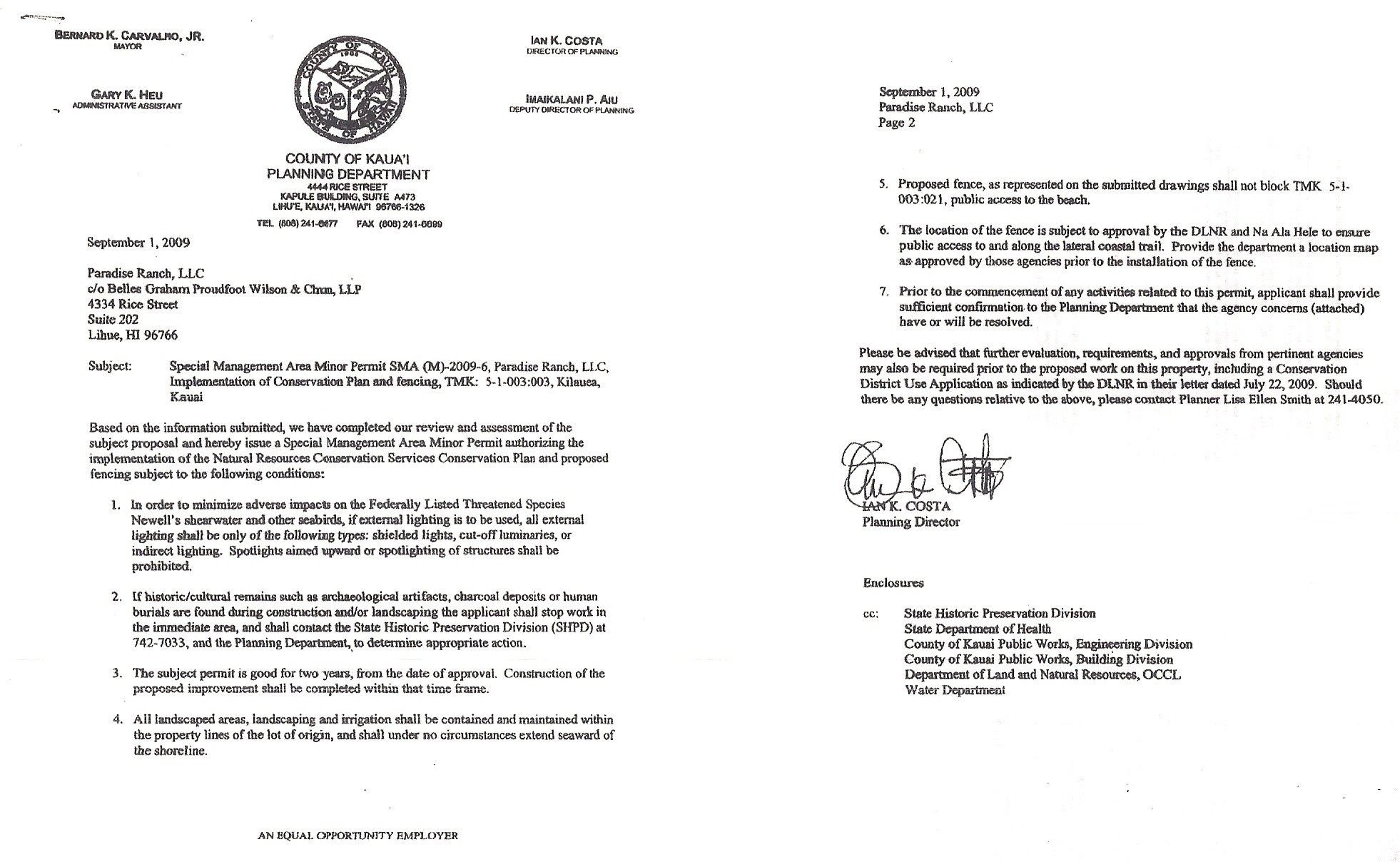
Shortly afterward, Laymon stated again his desire to fence off the lateral, coastal trail. He said he did not need a state permit as he still had a county permit. However, one of his county permit conditions states the lateral, coastal trail must be kept open.


Image above: Reproduction of detail of Paradise Ranch SMA Permit. Click on image to see original permit signed by Planning Director Ian Costa.

Note Condition 6: "...to ensure public access to and along the lateral coastal trail."

Since Laymon could not work any longer inside the state Conservation District, having surrendered his state permit, his fencing would have to be 300 feet from the shore, not 110 feet. This is because at Lepeuli the state Conservation District extends to 300 feet mauka of the shore. This boundary is set by the State Land Use Commission.

A major failing of the activists was focusing almost all attention on the state permit process, while ignoring the county permit, which is still valid today. When Les Milnes of Kauai County's Planning Department was asked how long it is valid, he answered "forever". This, despite it saying two years on the permit itself.

In May 2011 Laymon installed fencing across the lateral, coastal trail in violation of the county SMA permit. A public trail that was open for hundreds of years was suddenly closed. The state and county failed to protect the public trust and allowed private entities to take over public property that belongs to all the residents and taxpayers. How do public servants we all pay allow this to happen?

In June 2011 I appeared before the Kauai County Planning Commission where a petition I submitted was heard. I submitted a petition for An Order to Show Cause and requested the commission find Laymon in violation of the condition of his county SMA permit that forbade closing of the trail and order the fencing removed and impose fines. A memo from DLNR Chairperson William Aila was received the day before by the commission and planning department stating that the State can claim roads and trails in land-courted property.

In fencing the trail, Laymon was relying on a 2009 memo from Doris Moana Rowland, a DLNR abstractor, that said since the landowner registered the Lepeuli property in the Land Court back in 1943, the State could not today claim a pedestrian access. William Aila stated Ms. Rowland's memo did not represent the position of DLNR regarding roads and trails in Registered Land. The June 2011 memo was signed by Aila and two Deputy Attorneys General. Aila also noted DLNR approval for the fence location was not given, a condition of the county SMA permit. Upon advice of Michael Dahilig, current Kauai County Planing Director, my petition was indefinitely deferred.

At about the same time the State Land Use Commission issued a Boundary Interpretation for Lepeuli. This document was created by utilizing the map submitted by Paradise Ranch to Kauai County Planning and DLNR. The LUC drew on it their belief of where the boundary between the state Conservation District and state Agricultural District is.

Why is that important? Because Laymon, with the backing of Les Milnes in the Kauai County Planning Department, stated the May 2011 fencing is legal, as it is totally inside the state Agricultural District, and OUT of the state Conservation District, where Laymon no longer has permission to work. Of course, Milnes is ignoring the county SMA permit condition saying the trail cannot be blocked.

Laymon's surveyor, Alan Hiranaka, depicted the lateral, coastal trail, and the fencing that blocks it, entirely outside the state Conservation District. Community members with GPS devices disagree, opining that part of the fence is clearly inside the state Conservation District, and all of it that blocks the trail. The LUC feels the same way, their line is considerably more mauka of where Hiranaka placed the line. According to the LUC, the lateral, coastal trail is entirely inside the state Conservation District.

When the attorney for Waioli Corporation, Don Wilson, learned the Boundary Interpretation was issued, he rhetorically asked if it was accompanied by a current shoreline certification survey. It was not, as the Boundary Interpretation was requested by the Kauai Sierra Club, not the landowner, and the landowner did not have any such survey done, nor would they. The Land Use Commission rescinded the interpretation. The rules for shoreline certification surveys state only the landowner or authorized representative can request a shoreline certification survey.

All of this drama could have been avoided had the planning director at the time, Ian Costa, required Paradise Ranch to obtain such a survey as part of their county SMA permit application. He waived the requirement. Coastal parcels for which permits are applied for normally require a shoreline certification survey to determine setback. When the LUC Boundary Interpretation was sent to DLNR's Office of Conservation and Coastal Lands, and they were asked if they were convinced Laymon's fence constituted a violation inside the state Conservation District, Kimberly Mills, a staff planner in that office, replied "not yet".

During the summer of 2012 several sections of the fence came down, allowing access again. Beachgoers used the lateral, coastal trail as they always did. Toddlers, mothers with baby carriages, the elderly, bike riders, even someone on crutches. For months there was no response from Laymon.

On December 1, 2012 Laymon re-built the fence, this time extending it dramatically to enclose a two acre area the Kauai Planning department permitted as a "Seabird Protection Area". Thomas Kai'akapu of the DLNR Division of Forestry and Wildlife office in Lihue provided consultation. The same planning department that said the lateral, coastal trail could not be blocked in the SMA permit valid "forever", now grants permission for fencing that blocks the trail in not one, but two places!

Of course, the only purpose of the fencing is to keep people off the trail. The seabird protection area is the latest scam to propagate this desire of Laymon and his landlord.

On December 1, 2012 while Laymon was re-building the fence, the Kauai Police Department had three officers there, in an apparent show of solidarity with Laymon. They arrested a 68 year old homeless camper named James Decker aka "Catman"on Waioli property.

Beachgoers leaving Larsen's Beach the afternoon of December 1 noticed multiple pick up trucks in the cattle pasture with guys standing on the beds with long-armed guns (rifles or shotguns) in view of the beach access road. One beachgoer spoke with one of the guys who showed him a dead pig he said he just killed. So this show of guns to hunt pigs on the same day Laymon re-builds the fence is a coincidence?

One "hunter" was even parked on the county beach access road with his weapon clearly visible. This apparently was a show of force meant to say "This is mine, public keep out!" Instead of stopping Laymon from violating his SMA permit a for second time, the Kauai Police stood by making sure no one interfered.

They also did nothing about all the guns in plain view of the public. The public did not feel safe using this public property resource, the beach. I filed a complaint with the Kauai Police Commission regarding the KPD actions of December 1. The commission ruled that my complaint that the KPD stood by while a violation took place was unfounded.

I am actively interviewing surveyors and attorneys for resolving this issue in the interest of the public. If you would like to help with your professional services, please contact me, Richard Spacer, at rspacer@yahoo.com

.

Kekaha Beach Project

SOURCE: KEn Taylor (taylork021@hawaii.rr.com)
SUBHEAD: Disappearing Kekaha Beach is to have more than 80,000 cubic yards of sand restored.

By Cris Takushi on 23 October 2012 in Island Breath -

This post is from the content of a letter forwarded as email by Ken Taylor.
 
[IB Editor's note: There are those that think the recent "improvements" by the Army Corps of Engineers to Kikialoha Harbor upcurrent to Kekaha Beach was the source of its loss of almost the entire beach in the last year.]


Image above: Where once the Kekaha Beach lifeguard tower stood, now lies a graveyard of ironwood trees. From (http://www.hawaii-aloha.com/blog/2012/07/29/the-disappearance-of-kekaha-beach/).

Oceanit has been contracted by the State Department of Land and Natural Resources Division of Boating and Ocean Recreation (DLNR-DOBOR) to carry out this project.

The following is a summary of progress to date and some of the tasks that are coming up.
  • Project tasks underway.
  • Planning and Project Management
  • Coordination and meetings with agencies and affected groups.
  • Public Information Meeting held on 8/15/2012 at the Waimea Neighborhood Center.
  • PORTech Engineering of Lihue, Kauai has been contracted to do the Shoreline and Topographic Survey and has begun field work.
Right of Entry letters and e-mails have been sent out to affected landowners informing them of these surveys.
  • Research and Evaluation
  • Review of as-built plans from the State and US Army Corps of Engineers for the project area.
  • Review of previous studies and design data.
  • Review of past harbor modifications and maintenance.
  • Review of public comments and other public information.
  • Review of types of environmental controls required for alternatives.
  • Site Assessment
  • Assess possible borrow and stockpiling areas to take sand samples.
  • Planning for field work to take sand samples on east and west sides of harbor.
Tasks soon to be started.
  • Sand analysis of borrow and fill sites.
  • Feasibility Analysis
  • Evaluate different sand transport methods.
  • Conceptual Designs
  • Work with US Army Corp of Engineers to set up wave penetration gages


Image above: Hundreds of feet of sandy Kekaha Beach extended in front of lifeguard station as recently as a few years ago. From (http://hawaiiindependent.net/story/beyond-the-horizon-retirement-for-hawaii-residents-is-often-barely-there#.UIcKAIVBER5).

Background and Objectives
  • Design and develop a sand transport program to move sand from the up drift beach east of Kikiaola Harbor to the down drift beach west of the harbor. The program will include an initial transport of 80,000 cubic yards of sand to the eroded down drift beach and an annual sand bypassing scheme to nourish the down drift beach with 5,000 cubic yards of sand. The annual sand bypass would remove sand that has filled in the harbor entrance which is currently creating a safety and hazardous condition for harbor users. Cumulatively, these actions should reduce the rate of siltation, slow or stop the rate of erosion west of the harbor and improve the function of the harbor.
  • Prepare plans and specifications to repair damages to the west breakwater root structure. The continued beach erosion west of the harbor has damaged the root of the west breakwater by flanking. Continued erosion at this point will cut off the breakwater from land creating further damage to the shoreline.
  • Conduct a study to investigate the wave conditions at the dock and determine the degree of wave penetration. Although the docks have been repaired the facility is not a safe haven for docking boats because of potential damage caused by high wave action.
Oceanit plans to keep the landowners affected by this project and the users of Kikiaola Harbor and surrounding areas informed and involved. The project’s objectives were formulated by DLNR-DOBOR based in part on studies by the US Army Corp of Engineers, with a valuable amount of public feedback and concerns related to safety, liability and maintenance (boat docks, water depth, etc.) issues.

We welcome your feedback in the development of the solution. Please call, e-mail, or meet me in person during one of our site visits, which we will notify you in advance by e-mail throughout the project.

• Cris Takushi, is a Professional Engineer and the Project Manager for Oceanit. His number is
(808) 954-4129

.

Rising Oceans - Missing Beaches

SUBHEAD: Visited a missing Hawaiian beach lately? Get used to it.  

By Jan TenBruggencate on 1 July 2011 for Raising Islands - 
(http://raisingislands.blogspot.com/2012/07/visited-missing-beach-lately.html)

 
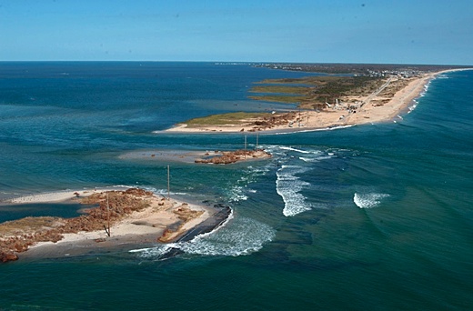
Image above: Hurricane Isabelle breaches an Outer Banks islands off North Carolina. From (http://www.seathos.org/earth-day-2012-the-top-5-threats-to-our-oceans-part-two/).
 

With the lack of aggressive action on climate change over the past decades, continued sea level rise is now essentially baked in, ocean and climate scientists are saying.

A study in the journal “Nature – Climate Change,”a new study argues that there’s little we can do now to prevent dramatic sea level rise.

Even with an aggressive program of controlling greenhouse gas emissions, sea levels will continue to rise based on our past misdeeds, write researchers Michiel Schaeffer, William Hare, Stefan Rahmstorf and Martin Vermeer. Schaeffer is from the Netherlands, much of which is below sea level, where accurate modeling of sea conditions is taken seriously.

He works with the Environmental Systems Analysis Group of Wageningen University and Research Centre in Holland. His co-authors are climate researchers from Germany and Finland.

Their message: A 50% change that sea levels will be a couple of feet (75-80 centimeters) higher than 2000 levels by 2100, if we can hold warming below 2 degrees Centigrade. And it will keep rising, they argue, to more than 8 feet by 2300.

We would not even recognize the coastlines of our great-great-grandkids . The islands would be significantly smaller as the ocean washes much higher on their shoulders.

“Halting (sea level rise) within a few centuries is likely to be achieved only with the large-scale deployment of CO2 removal efforts, for example, combining large-scale bioenergy systems with carbon capture and storage,” write Schaeffer and his team.

The globe needs to not only stop rising CO2 levels, but to drive CO2 production to negative levels, if sea level rise is to be slowed. Without that level of effort, imagine even larger rise.

The authors concede that the science of sea level change is still evolving and that there are many uncertainties—but they point out that current estimates are more likely to be low than high—thus, it could be worse than they now estimate.

“Physics-based models attempting to predict the combined contributions from thermal expansion, glaciers and ice sheets are not yet mature and underestimate the (sea level rise) observed in past decades,” they write.

There’s a fair amount of other alarming science out there. One piece is that sea level rise isn’t uniform across the oceans, and one group of researchers suggests that the northern Atlantic coast of the North America will see higher rise than other areas. It attributes this to salinity, currents, changing gravity and the Earth’s rotation.

“(Sea Level Rise) rate increases in this northeast hotspot were ~3-4 times higher than the global average,” write the authors of a paper, “Hotspotof accelerated sea-lkevel rise on the Atlantic Coast of North America.”

Add storm surge, and they predict serious vulnerability for harbors and coastal cities.

It doesn’t help that the popular media are screwing up the story. One big component of global sea level predictions is whether and how quickly the Greenland glaciers melt. Two recent pieces on the same day, May 3, 2012, had these contradictory headlines.

“Greenland’s ice melting more slowly than expected.”
"Greenland's glaciers melting faster, say scientists."

If you only read the headlines, you’d think those stories were contradictory. They’re not. The first one just says the glaciers are melting scary fast, but just not at breakneck speed. It says they’re not melting fast enough for 6 feet of sea level rise in the next 88 years—just 3 feet.

Well, three feet is enough to erase virtually every beach we now know in Hawai`i, to put much of coastal Honolulu underwater, to push Hilo and Hanalei Bays deep inland, to have significant impacts on coastal Kihei.

Have you visited a missing beach in Hawai`i?

If you visit the shore at all, you know the scenario. Where there used to be sand, there are rocks. Where there used to be palm trees and heliotropes, there’s water. Where kids used to build sand castles, there’s ancient sandstone washed by waves.

And that's just what's happening now.

Here is University of Hawai`i coastal geologist Chip Fletcher's famous progression of what happense to Waikiki under three feet of sea level rise--think street surfing.

See also:
Ea O Ka Aina: Wailua Beach Erosion 6/13/12
.