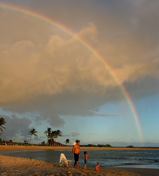
SUBHEAD: The Photo of the Day on TreeHugger.com is a rainbow as it falls over Kauai at sunset.
By Jaymi Heinbuch on 23 August 2013 for TreeHugger -
(http://www.treehugger.com/slideshows/natural-sciences/photo-day-rainbow-falls-over-kauai-sunset/)

Image above: Photo of Salt Pond Beach Park by Jaymi Heinbuch.
A tropical paradise isn't complete without a rainbow at sunset. During a break in a shower, a rainbow appears as a family plays at the water's edge.
Bozos out of touch at HI DOT
By Juan Wilson on 23 August 2013 for Island Breath -
(http://islandbreath.blogspot.com/2013/08/photo-of-day.html)
This photo above was featured today at the top of the popular website TreeHugger.com. The unattributed Kauai slocation above is taken from the area of the keiki beach at Salt Pond Beach Park in Hanapepe looking southeast. In the left-background is the location of Hawaiian salt gathering for the last 1,000 years. In the right-backgound is Puolo Point and a small airstrip.
Puolo Point is about 60 acres of grassland and windswept haole koa trees. It is a bird sanctuary with a magnificent view of much of the south and west sides of Kauai. Pueo owl s are frequently seen hunting at sunset.

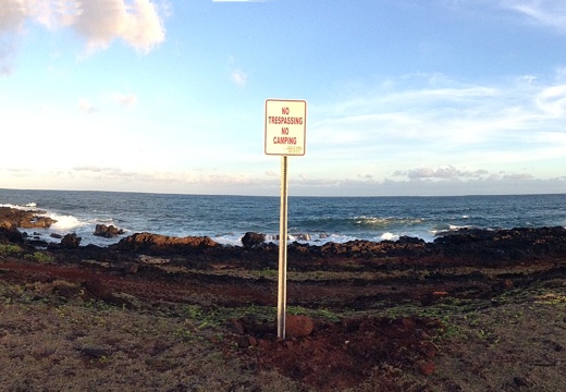
Image above: Photo of "No Trespassing" recently erected on othe alaloa path at Puolo Point. Click to see panoramic view.
In the last few weeks the Hawaii Department of Transportation Divisions of Airports have put up "No Trespassing No Camping" signs. Whoever put the signs up had the gall to set them outside the airport area and along shore in the traditional Hawaiian alaloa (belt trail around the island). These paths are the traditional route of Hawaiians and especially fishermen. The alaloa are not to be tampered with by foreign occupiers. Screw the DOT and the airport!
I can only imagine that this new directive by the DOT comes from fearfulness. Either it comes from the scaredy-cats at the US Department of Homeland Security, or it's an excuse to roust the occasional "scary homeless" person from camping in a place, off the road, where they can get some sleep.
I would rather have the current airport operations pack-up and go and leave the place to the birds and local people. Most operations within the DOT fence are tourist thrill rides including ultra-lights, parachuting and helicopter rides by an outfit that doubles up on income by flying "green harvest " runs and "special ops" for the Navy, DEA and KPD as well as ratting out hikers on the westside to Keith Robinson.

Image above: A photo from Puolo Point at sunrise titled "Fire, Air, Earth, Water" by Arius Hopman, of Hanapepe, Kauai, illustrating this article we posted trying to protect the area from further development. To see more of Arius' work start here (http://www.hopmanart.com/artwork_detail.php?products_id=55&278163f320da9a5285220a73).
.
By Jaymi Heinbuch on 23 August 2013 for TreeHugger -
(http://www.treehugger.com/slideshows/natural-sciences/photo-day-rainbow-falls-over-kauai-sunset/)

Image above: Photo of Salt Pond Beach Park by Jaymi Heinbuch.
A tropical paradise isn't complete without a rainbow at sunset. During a break in a shower, a rainbow appears as a family plays at the water's edge.
Bozos out of touch at HI DOT
By Juan Wilson on 23 August 2013 for Island Breath -
(http://islandbreath.blogspot.com/2013/08/photo-of-day.html)
This photo above was featured today at the top of the popular website TreeHugger.com. The unattributed Kauai slocation above is taken from the area of the keiki beach at Salt Pond Beach Park in Hanapepe looking southeast. In the left-background is the location of Hawaiian salt gathering for the last 1,000 years. In the right-backgound is Puolo Point and a small airstrip.
Puolo Point is about 60 acres of grassland and windswept haole koa trees. It is a bird sanctuary with a magnificent view of much of the south and west sides of Kauai. Pueo owl s are frequently seen hunting at sunset.

Image above: Photo of "No Trespassing" recently erected on othe alaloa path at Puolo Point. Click to see panoramic view.
In the last few weeks the Hawaii Department of Transportation Divisions of Airports have put up "No Trespassing No Camping" signs. Whoever put the signs up had the gall to set them outside the airport area and along shore in the traditional Hawaiian alaloa (belt trail around the island). These paths are the traditional route of Hawaiians and especially fishermen. The alaloa are not to be tampered with by foreign occupiers. Screw the DOT and the airport!
I can only imagine that this new directive by the DOT comes from fearfulness. Either it comes from the scaredy-cats at the US Department of Homeland Security, or it's an excuse to roust the occasional "scary homeless" person from camping in a place, off the road, where they can get some sleep.
I would rather have the current airport operations pack-up and go and leave the place to the birds and local people. Most operations within the DOT fence are tourist thrill rides including ultra-lights, parachuting and helicopter rides by an outfit that doubles up on income by flying "green harvest " runs and "special ops" for the Navy, DEA and KPD as well as ratting out hikers on the westside to Keith Robinson.

Image above: A photo from Puolo Point at sunrise titled "Fire, Air, Earth, Water" by Arius Hopman, of Hanapepe, Kauai, illustrating this article we posted trying to protect the area from further development. To see more of Arius' work start here (http://www.hopmanart.com/artwork_detail.php?products_id=55&278163f320da9a5285220a73).
.
No comments :
Post a Comment