Showing posts with label Beach Erosion. Show all posts

Kauai Northshore update

SUBHEAD: There is pressure on all local news sources to say nothing negative about impact on tourism.

By Neal Chantara on 1 May 2018 in Island Breath-
(http://islandbreath.blogspot.com/2018/05/kauai-norhshore-update.html)


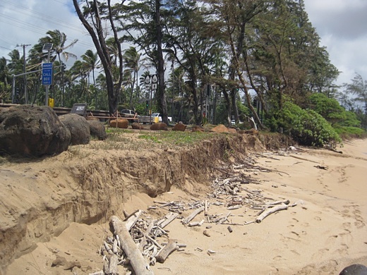
Image above: An upscale north shore raised residential structure "totaled" after being knocked off its foundation from flood waters eroding the earth around the column footings. Note half the yard looks like a putting green and half is a washed out gully. Photo by Jamm Aquino. From (http://www.staradvertiser.com/2018/04/16/photo-galleries/photos-aftermath-kauai-flooding/).

We are high and dry, but many did get wet. Mold and the high levels of contaminate in the flood waters (the water is actually "black water" from sewage, gas and oil from vehicles, etc) are making homes unlivable.

 Some people aren't aware of the danger and are simply throwing out furniture and planning to move back in.

I've been a designer and builder of healthy homes. I know better and have been researching what to do for wood that has been contaminated by these types of flood waters.

But what is so heartening is, the outpouring of support on this island. Differences have been put aside. So many volunteers. The federal and state agencies won't deal in any food other than non-perishables.

The locals with boats coordinated with locals with farms or money to buy apples, etc and a supply line of fresh food is going out to the island past Hanalei.

I spoke at length with a friend living way out there yesterday. People are picking up their trash at the road edge. Each house was delivered 5 gallons of gas. There's a free thrift store for clothes.

I was told the Hanalei Court House has more boots available than a big box store. The Hanalei Colony Resort, beyond the landslides, has been offering free breakfasts and dinners.

My friend said people are saying they are eating better now than before the flood.

Now one lane is open to emergency vehicles only. She said people out there can sign up the night before and a shuttle that leaves at 6am goes out. It will return at 6pm.

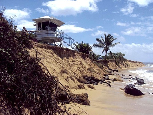
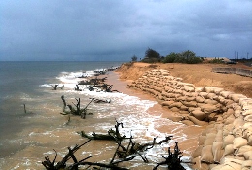
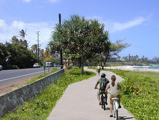
We continue to do our 2 mile walks at a couple beaches around here. They still stink. The beaches of the north shore are too contaminated to be in. However a friend said he heard the mayor on the local radio say he had a letter from the Dept of Health giving the OK to swim again!

The tourist bureau is under so much pressure. Business has really fallen off. Our daughter is a fashion designer supplying clothing to Chanterelle Couture, with four island stores and a couple on Oahu

One of Chanterelle's store owners told her that the entire week was 60% less business than normal.
Her two stores are on the other side of the island from the storm damage.

 A friend of ours, who is managing forty-two vacation rentals, had a call from a mainland person who had a booking in a place unaffected by the flood for next October - they wanted to cancel.

There is pressure on every news source in all of Hawaii not to say anything negative as so many mainland people do not differentiate between islands or part of islands and Hawaii.

They seem to think of Hawaii as one small state rather than small islands widely separated.

Many organizations have organized to help. I went by one Hanalei church with a sign out front "Free Water, Clothing, Food". There is a group of volunteers fixing homes for free.

So that's a quick update of the island news, but the real place to focus is on the Aloha.

See also:
Ea O Ka Aina: Storm damage on Kauai 4/24/18

.

Sand Wars

SOURCE: Ray Songtree (rayupdates@hushmail.com)
SUBHEAD: In the coastal countries of Africa, such as Morocco and Sierra Leone, “sand mafias” have sprung up.

By Tom Lewis on 13 July 2016 for The Daily Impact -
(http://www.dailyimpact.net/2016/07/13/sand-wars/)


Image above: A sand mafia in Sierra Leone in the process of stealing a beach. With just a little more finesse, they do it in Miami, too. From original article.

The human industrial complex requires enormous inputs of natural resources to build and extend itself. If you rank these raw materials by volume used, number one will be water. Number two will be sand

Hard to accept? Go anywhere in the world and look around. If you’re in a city looking at a high-rise building, it’s probably mostly concrete (sand), just like the streets, sidewalks, bridges, and the freeways with their interchanges and ramps. The windows in the skyscrapers and storefronts are glass (sand). Some buildings are made of brick (sand) or block (sand).

 And some of the highways are asphalt (sand). Out in the country most houses may be framed with wood, but they rest on foundations and basements of concrete and block, and many of them are roofed with asphalt shingles. I’m finding this out, and telling you about it, using computer chips made of sand.

The world uses a lot of sand; 50-60 billion tons a year, according to the United Nations Environment Programme , and the demand curve continues to climb precipitously in Asia. China poured more concrete in two years, 2011-13, than the United States poured in the entire 20th Century. The fracking revolution that recently gripped the US oil industry is built of sand, as well; by 2012 frackers were using  30 million tons of sand a year, nearly overwhelming the existing supply chain.
Of course, we are running out of sand. Like fossil fuel, it takes thousands of years to produce, and we are using it far faster than the world can replace it. As with everything else, our response to this rapidly approaching existential crisis is to use the stuff faster.
One additional supply-limiting factor is that desert sand, rounded and smoothed by wind, cannot be used for most purposes, only water-shaped sand, which retains its jagged edges and binds well with others. All over the globe, sand is being dredged from the ocean floor, scooped up from river beds and scraped off beaches; it’s a 70-billion-dollar-a-year industry, most of which is either unregulated or flatly illegal.

The environmental damage being done is immeasurable. The thousands of large dredge boats working the coastal oceans of the world are disrupting ecosystems, killing marine life and altering the ocean’s currents and tides. Sand in the ocean doesn’t just lie there, it moves constantly, coming off one beach and fetching up on another, moving off shore and then into shore and along the shore.

Always it tries to stay in equilibrium as it reacts to storms, construction — and dredging.
Sand dredging off the Florida coast, to provide raw material for more tourist hotels and residences, is the main reason Miami’s beaches “erode” so much every year that they have to be replenished with dredged sand — so the tourists in their sand buildings will have sand to walk on as they contemplate the timelessness of the ocean and the majesty of unspoiled nature.
The sand industry (setting aside ocean dredging) is unusually accessible to poor people, and can be practiced on a small scale that is difficult to detect and regulate. But the easily accessible deposits, on land and along stream beds, are almost all gone now and the competition for what remains is fierce.

In the coastal countries of Africa, such as Morocco and Sierra Leone, “sand mafias” have sprung up that fight each other for their sand the way the real Mafia fights for its drug territories.

The good thing about these sand wars is that although they will get worse toward the end of the human industrial complex, they will expire with it. We will not have need of skyscrapers and superhighways after the crash. We will be fully occupied seeing about food and water.

The Bible calls us foolish if we build our house upon sand. What do you call people who build a global economy made of sand?

.

DLNR Kekaha Shoreline Meeting

SOURCE: Kauai Chapter Surfrider (surfriderkauai@gmail.com)
SUBHEAD: DLNR meeting to discuss the Kekaha upcoming Sand Bypass System and Breakwater root repair projects.

By Eric Yuasa on 12 August 2013 in Island Breath -
(http://islandbreath.blogspot.com/2013/08/dlnr-kekaha-shoreline-meeting.html)


Image above: in the summer 2011, the Kekaha Beach lifeguard tower stood at the edge of a dropoff into the ocean. From (http://thegardenisland.com/news/local/kekaha-lifeguard-tower-on-the-move/article_6aae0854-c187-11e0-b880-001cc4c002e0.html).


The State Department of Land and Natural Resources, Division of Boating and Ocean Recreation invite you to attend a public information meeting to discuss the upcoming Sand Bypass System and Breakwater root repair projects.  The plans have been completed and the bids are being solicited on the State of Hawaii Electronic Procurement System.

The Public Information Meeting will be held:

WHEN:       
Thursday, August 15, 2013 from 6:00pm to 7:30pm 
    
WHERE:   
Kalaheo Neighborhood Center
4480 Papalina Road, Kalaheo, Kauai
                              
Your attendance at this meeting will be greatly appreciated.

Should you have any questions, please call:

Ms Andrea Kualapai at 587-0175 or
Mr. Eric Yuasa, Boating Engineer (DLNR) at (808) 587-0122.

Sincerely,
Eric Yuasa


Image above: Looking West. In the spring of 2012, where once the Kekaha Beach lifeguard tower stood, lies a graveyard of ironwood trees. From (http://www.hawaii-aloha.com/blog/2012/07/29/the-disappearance-of-kekaha-beach/).

.

Coco Palms Travesty

SUBHEAD: The  Coco Palms Hui LLC operated by Chad Waters and Tyler Green sounds like a scheme to skim some money off investors.

By Juan Wilson on 10 August 2013 for Island Breath -
(http://islandbreath.blogspot.com/2013/08/coco-palms-travesty.html)


Image above: Eighty-four year old Larry Rivera sings a duet with a wax statue of Elvis Presley at the re-landscaped Lagoon on the grounds of the gloriously  restored Coco Palms Hotel. Photo image mashup by Juan Wilson.

Look how the Garden Island News Online poll on 8/10/13 conducts a survey of public opinion. The question they pose is:
"What would you prefer to see happen to the Coco Palms?"
The possible answers to that question are:
  1. Restored to former glory
  2. Public Park
  3. Affordable housing
  4. Shopping center
The result was 95% who took the poll as of 8:35am 8/10/13 answered either 1 (67%) or 2 (27%). Suppose the question for 1 and 2 had read:
  1. Another hotel, time share development on the east side.
  2. Public center for Hawaiian cultural and nature preserve.
My guess is the the results would have been dramatically different. It should be noted that the Garden Island News is no longer a Kauai publication. It is now owned by an Oahu corporation. The same place the hopeful developers, Coco Palms Hui LLC come from. Their PR agent seems to be doing overtime on Kauai lining up our Mayor and Planning Director and TGI Editors.

It is highly doubtful that the hotel being built will ever reach the "former glory" of the original Coco Palms that evokes it as the hangout of Frank Sinatra and Elvis Presley. No one today would build open air hotel like the Coco palms with a "natural lagoon" (more likely a filtered chlorine  treated cement swimming pool with water slides).

But even more to the point. The Coco Palms site is no longer a good site for what made the Coco Palms great 40 years ago. The Coco Palms was a destination resort with no neighbors on its stretch of Wailua Beach. It wasn't on a commercial strip with the worst traffic on the island.

Moreover, the first things tourists coming to Kauai do these days is rent a car. They get out their "secret sites of Kauai" guide and head out to see them all in three days. Forty years ago the destination hotels arranged for horseback trips at nearby stables, bus scenic trips for picnics at eastside waterfalls, etc. They provided things to do in the day and entertainment at night.

On top of that, the Coco Palms site is clearly in the crosshairs of natural beach erosion and global warming induced ocean rise. A mere year ago the ocean was threatening to reach the Kuhio Highway immediately in front of the southeast corner Coco Palms site. See Ea O Ka Aina: Wailua Beach Erosion 6/13/2012.

Erosion due to waves and wind had cut away what was once over 150 feet of sandy beach and reduced it to less that twenty feet. Spray from breaking waves occasionally reached the highway blacktop.

It needs to be understood that natural water erosion from rain and ocean waves wears away the Hawaiian islands over time. Just look up the Northwestern Hawaiian Islands toward Midway to see our future. The vast majority of coastline retreats a little back from the ocean every year. There is some give and take - but mostly take.

Eventually the there will have to be relocation of our perimeter highway in some places. Over the last couple of years ocean spray was crossing the Kumualii Highway in many parts of Kekaha. In the last year a major mitigation effort was made to save the Kaumualii Highway from being crossed by the ocean. Heavy riprap stone embankments now replace what was a deep sandy beach. The Life Guard tower at McArthur Beach park had to be relocated inland and westward three times in a year.


Image above: Looking toward the restored stage in the Coconut Palace restaurant of the Coco Palms Resort as Eddie Palmieri and his musicians perform. Meanwhile displayed front and center are wax figures of Frank Sinatra and Ernest Borgnine in a re-staging the bar fight scene in the movie "From Here to Eternity" filmed in Hawaii. Mashup by Juan Wilson.

Residents and tourists alike are familiar with how bad the traffic can be in front of the Coco Palms and northward all the way through Kapaa.  Since the "glory" days of the Coco Palms the eastside, and particularly the Kapaa shopping strip has been highly developed by suburban sprawl.

The Kuhio Highway passage over the Wailua River and in front of the Coco Palms is a critical choke-hold on traffic on Kauai. There is no inland passage upstream on the Wailua River--just the highway. If the Kuhio Highway is inundated by the ocean the island is effectively cut in two. There is no easy way to cross the Wailua River inland of the Coco Palms site.

It is best for the Coco Palms site to be a public park, nature preserve and/or Hawaiian cultural center. At some time in the future some part of it will be available to the people of Kauai to cross the island north and south without having to deal with the ruins of another private hotel development deal.

There is already another plan in place for this site - in part a Hawaiian Cultural Center and public park. The Kauai Public Land Trust has been working with the Friends of Coco Palms and others to convert much of the site for Hawaiian cultural use and a public park. 
"Kauai Public Land Trust is proud to be the fiscal sponsor for the Friends of Coco Palms. A committee of community leaders, the Friends of Coco Palms is committed to acquiring the historic Coco Palms Resort property for public benefit."
As recently as last Thursday, August 8th, the day before the resort "restoration" was covered in the Garden Island, Jennifer Luck of the Kauai Public Land Trust was interviewed by Jonathan Jay on the Kauai Community Radio program Out of the Box. She was not aware of the certainty of any rebuilding of the hotel. See article below.

The  Coco Palms Hui LLC is operated by Chad Waters and Tyler Green. It sounds like a scheme to skim some money off investors on a project that will never achieve full financing. This Saturday morning Chad and Tyler are probably out on a golf green on Oahu chuckling on the gullibility of their next victim.

On top of that our Kauai Mayor Bernard Carvalho and Planning Director Michael A. Dahilig should be embarrassed by their participation in this travesty.


Coco Palms to be reborn 

By Leo Azambuja on 9 August 2013 in the Garden Island
(http://thegardenisland.com/news/local/coco-palms-to-be-reborn/article_05515b0e-00bf-11e3-a437-001a4bcf887a.html)


Image above: Larry Rivera (r) and Chad Waters (l) trade shakas at after the blessing of the Coco Palms sight and the beginning of demolition work that will lead to the glorious restoration of the historic site.

The iconic Coco Palms Resort in Wailua received a new breath of life. An Oahu-based group of investors announced Thursday the property is in escrow, and they have already secured demolition permits.

“This is so exciting,” singer-songwriter Larry Rivera screamed as he walked onto the property, both hands in the air throwing shakas. He started his career at Coco Palms in 1951, and worked there until the hotel shut down following Hurricane Iniki in 1992.

“If everything goes well, we’ll start construction in the first or second quarter of next year,” said Chad Waters, one of the members of the newly-formed Coco Palms Hui LLC.

Waters and Tyler Green represent a group of local investors who want to rebuild the property as a “2014 version of the original Coco Palms.”

“We pulled the (demolition) permits today, we actually pulled 28 separate demo permits,” Waters said Thursday. “It was about $50,000 in demo permits.”

In about four to six weeks, the Hui intends to submit building plans in accordance with the last remaining Iniki Ordinance, which allows for the restoration of non-conforming structures to their pre-Iniki condition, without current, stricter health and safety standards. Once rebuilding starts, Waters said it will take between 12 to 24 months to deliver a hotel close to what it was like before the hurricane.

Waters said the 396-room Coco Palms will be rebuilt with the existing square footage, under the guidance of what is allowed by the Iniki Ordinance. The three main buildings will be stripped down to their concrete structure. All wooden buildings will be rebuilt just the way it was.

“We’re going to highlight the Elvis (Presley) bungalow, Larry Rivera — all of the things which made Coco Palms special we’d like to continue,” he said.

The 83-year-old Rivera could hardly contain his excitement, screaming like a teenager and lifting up his hands several times.

“I talk to (Mayor Bernard Carvalho Jr.) a lot,” he said. “I said, ‘Bernard — I call him Bernard — 90 percent of the local voters want Coco Palms back, do something, help them.’”

At noon, workers from Craig Kawakami Builders gathered for a blessing of the hotel before they started removing overgrown weeds on the perimeter of property to install dust screens.

Waters said workers will be placing 1,500 linear-feet of dust screens around the property, and security will tightened to stop vandalism and theft.

The property is still in escrow — for an undisclosed amount — until the building permits are obtained, according to Waters.

Coco Palms Ventures LLC held building permits for eight years, but could not find the right investors to rebuild the hotel. Their permits expired in January. But Waters said those permits were for a complete demolition and rebuild under a different plan.

“That doesn’t affect us at all because we are not using that plan,” he said. “We’re rebuilding what is here.”

On July 9, with support from Carvalho and Planning Director Michael Dahilig, the Kauai Planning Commission voted to repeal the last Iniki Ordinance.

Waters said the project now has the support of Carvalho and Dahilig, and the Iniki Ordinance is still law. The Hui has the right to rebuild the property the way it was, “and that’s what we intend to do.”

Alan Veach, representing a group of investors working on the Coco Palms Resort, realizes the significance of the work he’s doing.

“Everyone’s got a story about Coco Palms,” Veach, who is currently supervising other projects on Kauai, said during a brief blessing Friday morning.

Work on clearing overgrowth along the fence line started Thursday afternoon, but the blessing officiated by Lady Ipo Kahaunaele-Ferreira commemorated the work starting on the resort, which has been closed since being damaged in Hurricane Iniki in 1992.

“Over the years, we have heard many plans for the Coco Palms property, but this is the first time we’ve seen real action,” said Mayor Bernard Carvalho Jr. after learning that demolition permits for the Coco Palms property have been obtained by the Coco Palms Hui.

“There is no way to predict what will happen, but it has always been my hope that whatever happens with the property, its historical and cultural significance will be preserved,” the mayor said.

Craig Kawakami of Craig Kawakami Builders said his crews are tasked with putting up dust screens along the perimeter of the property.

“We started clearing the overgrowth Thursday,” Kawakami said. “We should be finishing up today. Roger Taniguchi will remove all of the material, and we’ll start putting up the dust screen.”

Planning Director Mike Dahilig, in a release from the county, noted that only a demolition permit has been sought at this time.

“Any future permit applications by Coco Palms Hui will be evaluated appropriately as the law provides at the time of submittal,” Dahilig said.

Carvalho, in June, initiated a bill that would repeal the remaining provisions of the so-called “Iniki ordinance.” The bill was approved by the Planning Commission.

The Iniki ordinance allows for the restoration of a non-conforming building or structure to its pre-Iniki condition.

The bill is expected to be forwarded to the Kauai County Council by the Planning Department within the next two weeks for its consideration.

See also:
Island Breath: Kauai Lagoons False Advertizing 3/18/08
Island Breath: Koloa Landing 6/28/2007

Eroding Kauai

SUBHEAD: Human activity to date has accelerated the erosion of our island. It doesn't have to be that way.

By Juan Wilson on 16 March 2013 for Island Breath -
(http://islandbreath.blogspot.com/2013/03/eroding-kauai.html)


Image above: Detail of seamount map of the Hawaiian islands focusing on Kauai county. Click to enlarge for whole map. From (http://catherinesherman.wordpress.com/2011/03/08/living-at-the-edge-of-a-volcano/).

An Alien Adventure
Let me invite you to a sci-fi thought experiment in the distant future.

This experiment begins millions of years in the future. Aliens have crash landed their spaceship on Earth, in central Eurasia. They have survived with enough gear to maintain their lives and record their discoveries. What to do? Go exploring!

Don't worry about invading aliens taking over and hunting down the humans survivors. This late in the Earth's history the atmosphere has already boiled off along with the oceans.

The aliens look at the geological history. They are searching for signs of past life on Earth. There is little anthropological evidence, but there appear to be a mineral traces of a record of life on the planet.

After working their way thousands of miles east they come to a gigantic desert  basin that seems to cover half the world. What to do? Cross it!

The alien troupe work their way across thousands of miles with delays at deep chasms cut into the basin. Finally they see in the distance a tight group of mountains on the horizon.

As they near the mountains they realize that the mountains are the highest they have seen on the planet. Ten-of -thousands of times their own body heights.

When they finally reach the foot of the nearest mountain they realize how steep they are. What to do? Climb!

They leave the flat basin below and take the harrowing climb to the top.

It is only when they reach the top that they can see that all the mountains are exactly the same height above the basin.

There are no pinnacle because the tops of every mountain has been sheared off at the same elevation leaving behind a flat plateau many miles in diameter.

What force could have cut off the tops of all these mountains at the same height?

One alien's eye sparkle before the rest. With words we would not understand he/she utters one word - WATER.

There must have been an abundance of surface liquid water here like we have never seen before; deep enough in miles to reach the very pinnacles of what was here once - ISLANDS.

The Arc of Kauai
An experience in the past  about the not so distant future.

In 1972 I attended a lecture at the Lihue Public Library that was given by a University of Hawaii professor of geology.

The presentation was largely made with a slide projector and showed the geological formation of an island from the first undersea mount, through a series of volcanic eruptions that raised the mountain out of the sea.  The midpoint of the lecture was the island that today is familiar to us as Kauai.

The next half of the presentation followed the projected future of the island as it eroded back into the ocean, until it became a flat atoll, just a few feet above the waves. That fate will be within the next 2 million years.

From then we'll ride the Pacific tectonic plate northwest as an atoll. In another 65 million years, as a seamount, we'll be sucked under the North American tectonic plate as we meet the Aleutian Islands. Such is fate.

We Are Only Human
What can mere humans do facing the scale of these events? Well, what we are doing is everything we can to hurry things along to reach living on an eroded desert island!

It is water that erodes the island in the form of rainwater and ocean swells.

The rain comes in great quantities on a few areas and courses it way down the landscape cutting away earth a stone. Ultimately, that material is carried to the ocean, not to be returned. That is a natural phenomena, but humans accelerate the erosion by cutting forests, paving over land, and irrigating fields.

The ocean waves come to the island and their violence can be softened by reefs, beaches, dunes and wetlands. Over 70% of our coastline is in retreat, many areas by a few feet every year. A few feet a year is not unusual.

The drama seems only to weigh on us when the ocean spray begins landing on our perimeter highway, as it has at Wailua and Kekaha. As we damage or destroy these fragile places the erosion of Kauai is accelerated.

Just look what the military alone has done to Pearl Harbor on Oahu and what "agriculture" has done to the Mana Plain on Kauai. One was dug out for warships the other filled in for sugar (and now GMO high-fructose  corn syrup and the Pacific Missile Range Facility or PMRF).  These two areas were the largest wetland systems in the middle of millions of square miles of Pacific Ocean. That domain is now under the control of the US Navy for the purpose of "testing" weapons and "war-games".

The Task at Hand
Restoring the critical cross-sections of ocean to land would allow both fresh and salt water fish and fowl to flourish once again. Let's start with Mana Plain and Pearl Harbor by making them once again extensive brackish wetlands. Restoration of the areas between our reefs and wetlands will help slow the erosion of our shorelines.

Besides protecting and enhancing the health of reefs, beaches, dunes and wetlands in order to protect our shores we can do a great deal to reduce erosion by rainwater as well. This is achieved primarily by slowing the course of water on the land.

There are many techniques for doing this including charging groundwater; holding water in reservoirs; distributed aquaculture; collecting and storing rainwater for residential use; and using water through the principles of organic permaculture.

The key is to slow down the course of the water on the land with uses that are beneficial -  beneficial in that they increase life and its diversity. What better task could we have?


.

Restoring Molokai Sand Dunes

SUBHEAD: The results are remarkable. Some of the cleared areas, originally bare sand, now support dense mats of Hawaiian coastal species.

By Jan TenBruggencate on 15 February 2013 for Raising Islands -
(http://raisingislands.blogspot.com/2013/02/nature-conservancy-restores-molokai.html)


Image above: Native vegetation restored to a Moomomi, Moloka`i sand dune. From original article.

Fragile sand dunes of Moʻomomi on Molokaʻi, once overrun with alien kiawe thickets, are blooming with new native growth.

A 14-year passive restoration program by The Nature Conservancy and the Molokaʻi Land Trust is letting the blue blossoms of paʻu o Hiʻiaka and the yellow flowers of ʻilima bloom amid the spiky native ʻaki ʻaki and shimmering hinahina.

That’s on dunes that once held single-species thickets of the introduced legume, kiawe (Prosopis pallida), which was brought to Hawai`i to support cattle ranching.

“Kiawe transforms the ecosystem. It forms dense thickets. If there’s a fire, it burns hot and hard. Since it’s a legume and fixes nitrogen, it changes the soil,”said Russell Kallstrom, graphical information system coordinator for the Conservancy's MolokaÊ»i Program.

Kiawe removal combined with predator and weed control benefits not only native plants, some of them rare, but also the uaʻu kani or wedge-tailed shearwater. The number of wedge-tailed shearwater burrows has increased from 3 nests in 1999 to 704 nests in 2012.

“It seems like the shearwaters were trying to recolonize before 1999, but feral cats used the safety of kiawe thickets as staging areas for raids on the nests,”said Wailana Moses, the Conservancy's Moloka'i weed coordinator. “When we removed some of the kiawe clumps near the bird colony, we would find piles of shearwater wings.”

The shearwaters face a three-pronged mammal threat: mongooses would prey primarily on eggs, cats would take birds one at a time, and dogs would occasionallywipe out dozens at a time. In 2009, a single dog killed 60 shearwaters in one night.

The Nature Conservancy began kiawe control at its 921-acre Moʻomomi Preserve in 1998, under the direction of its Molokaʻi Program manager, Ed Misaki.

“The idea of passive restoration was to focus on removing invasive species and let the natives naturally regenerate—removing the threats and allowing thenative system to heal itself, basically,” Misaki said.

The conservation crews learned as they went along. One key strategy was to remove kiawe next to intact native sand dune habitat so the natives could reclaimthe open area naturally.

Another technique was to quickly paint a small amount of herbicide on the cut kiawe stump, to prevent it from re-sprouting. Still another was to use a chipper to grind up kiawe branches,  creating mulch that helped the native crawling plants and inhibited weeds.

“We learned that if we took out too much kiawe, we would have a hard time keeping up with removing weeds coming into the area—primarily buffel grass, foxtail, golden crownbeard,
Australian saltbush and a non-native goosefoot,” Moses said.

The Ê»akiÊ»aki grass was generally the first species to move in after kiawe removal. “The chips slowed the weeds down a little and helped the Ê»akiÊ»aki grow into the area,” she said.“Little by little, the other species came in like Ê»enaÊ»ena, kaunaoa and Ê»akoko, even the rare Solanum nelsonii (popolo),” Moses said.

Kallstrom said the native plants do better on some of the land you’d think was the worst habitat for them—the northeast sides of dunes, which are blasted by the trade winds and regularly doused with salt spray. Most of the weeds can’t handle the salt; the coastal natives by contrast are adapted to it.

“It’s really an amazing thing to see. After the kiawe is removed and the chips cover the open area, the natives just crawl in from the outside. The Ê»akiÊ»aki turns fluorescent green when it hits the nitrogen left by the kiawe chips," he said.

The kiawe occurs in patches across the MoÊ»omomi dunes, and the removal process, since increments must be small, has cleared a little over 9 acres in the program’s 14 years. For most of that period, it was done by Conservancy staff and volunteers, but since 2010, some of the work has been contracted to the MolokaÊ»i Land Trust, which also does weed control.

The results are remarkable. Some of the cleared areas, originally bare sand, now support dense mats of Hawaiian coastal species.

• The Nature Conservancy is a leading conservation organization working around the world to protect ecologically important lands and waters for nature and people.

The Conservancy and its more than 1 million members have protected nearly 120 million acres worldwide. Visit The Nature Conservancy on the Web at www.nature.org.


.

Arrests at Wailua Beach Path

SUBHEAD: James Alalem and Ray Catania were arrested defending Hawaiian culture at site of Wailua Bike Path.

Reported by Sharon Goodwin on 6 February 2013 in Island Braeth -
(http://islandbreath.blogspot.com/2013/02/arrests-at-wailua-beach-path.html)


Image above: James Alalem dislplaying typical stone that was used to mark the outline of a body at a burial site. From (http://islandbreath.blogspot.com/2012/07/wailua-burial-site-conviction.html).

This morning at about 8:20am on February 6th, 2013, James Alalem and Ray Catania were arrested by Kauai County Police at the site of the bike path that is under construction on the dune of Wailua Beach north of the Wailua River, on Kauai.

They were arrested after the management of the construction contractor called police and indicated that the site was being blocked by demonstrators. After their arrest they were taken to Kauai Police headquarters.

Ray and James have put their bodies on the line for some time in trying to protect burial sites in an area that has many sacred places in Hawaiian culture.


Image above: Ray Catania stands next to siting of Wailua Bike Path demonstrating how close the surfbreak is to highway. It used to be about 190'. From ().

See also:
Ea O Ka Aina: Leading by Bad Example 1/28/13
Ea O Ka Aina: Wailua Beach Under Water 8/26/12
Ea O Ka Aina: Wailua Burial Site Conviction 7/19/12
Ea O Ka Aina: Wailua Beach Erosion 6/13/12

.

Leading by bad example

SUBHEAD: Why is Kauai County hellbent on this expensive, destructive and foolhardy course? And what will it take to stop this madness.

By Joan Conrow on 28 January 2013 for Kauai Eclectic -
(http://kauaieclectic.blogspot.com/2013/01/musings-bad-example.html)


Image above: Wailua Beach in 1981 looking south, when the beach was much wider. From original article.

The county is proceeding with construction of the concrete Path at Wailua Beach even though its special management area (SMA) permit for the project has expired.

The SMA permit for the section of the path between Lydgate and Lihi parks was approved in 2007, with the condition that “Applicant shall commence construction of the proposed project within 2 years from the date of Planning Commission approval of this Special Management Area permit, and complete construction within 4 years.”

Now an ordinary person would read that as construction should have begun by 2009 and be pau by 2011, which it wasn't. The county, however, is saying no, that language means 2 + 4, or six years to complete. So what? Is the county now going to give every other developer similar latitude?

Further, the permit was approved when the plan was for a boardwalk on the beach. The design has been changed substantially to a concrete path alongside the highway, which should have triggered another review by the Planning Commission. But the last thing the county wants is to reopen the public process.

Instead, it's setting a terrible example by building public infrastructure too close to the ocean through use of a shoreline setback variance. It's also armoring the coastline through its use of concrete — please don't tell me a concrete foot path attached to a 3.5-foot thick wall isn't a seawall — and intensive vegetation.

At least, it sure sounds like intensive vegetation, when you consider they're spending $4,000 on beach heliotrope and another $4,000 on hala, all in 25-gallon pots. No quantity is specified, which would make it awfully hard to determine whether the supplier actually fulfilled the contract. Another $10,000 is allocated for 1-gallon pots of naupaka, again with no quantity specified.

Then there's $15,000 for grass seed that is apparently mixed with gold dust at that price in addition to $6,000 for hydromulch seeding. Though why we would want to put a chemical concoction that close to the ocean is beyond me.

Take a gander through the rest of the budget. (Scroll to the end of the document.) Some $584,000 is being spent on concrete, and $145,000 for reinforcing steel. That's to make sure if you hit that wall with your car, it's guaranteed to be a big smashup. Another $230,000 is budgeted for rock facing on the concrete wall. Additionally, $42,500 is earmarked for cops and other traffic controls, with $25,000 allocated for archaeological monitoring. The pavement markers are $8,000, though it's hard to know exactly what we're paying for, as again, no specific quantities are listed.

Some $13,000 is budgeted for signs alone – gee, who would've thought a mile marker sign cost $1,500?

Which makes me wonder how much the sign cost that was put up right in the middle of Kuhio Highway — and run over within a day — advising motorists of the new crosswalk that's been installed between Kawaihau and Hauaala roads, one of the most congested sections in Kapaa. The crosswalk was painted so people could get from the Kawaihau spur, which is not yet pau, to the coastal Path.

Yet for some reason the county says, no, we can't possibly have the Path crossing the highway at either Safeway or Kuamoo Road, both of which have crosswalks and traffic signals. What's up with that? Like so much of the Path "planning," it's all rather ad hoc and opaque.

Meanwhile, a reader sent a photo showing how broad Wailua Beach was in 1981. The county keeps claiming it's accreting — a fancy word for growing — but we all know it hasn't been this wide for decades.

Two questions remain: why are Mayor Bernard Carvalho Jr., Lenny Rapozo, Doug Haigh and Thomas Noyes hellbent on this expensive, destructive and foolhardy course? And what will it take to stop this madness before it's too late for what's left of Wailua Beach?

.

Wailua Beach & Bike Path

SUBHEAD: An important meeting on the fate of the Bike Path plan along disappearing Wailua Beach.

By Judy Dalton on 2 January 2013 in Island Breath -
(http://islandbreath.blogspot.com/2013/01/wailua-beach-bike-path.html)


Image above: Traffic along the Kuhio Highway is not far from the spray of breaking surf today. When the Bike path along the beach was suggested the blacktop was over 150 feet from the shorebreak. From Judy Dalton.

WHAT:
Special County Council Meeting on Bike Path at Wailua Beach.

WHERE:
Historic County Building on Rice Street in Lihue.

WHEN:
Part 1 - 8:30AM-12:30PM on January 4th 2013.
Part 2 - 1:30PM TO 3:00PM on January 4th 2013

A path that goes along the coast may sound like a nice idea. But is it really a good idea for Wailua Beach if it means that the County's concrete multi-use bike path along the upper portion of the beach will likely cause irreversible environmental and cultural damage?

REGARDING COUNTY COUNCIL 
Please come to the Special County Council meeting this Friday, January 4 at the Historic County Building on Rice Street from 8:30AM-12:30PM about the concrete bike path project at Wailua Beach, followed by another meeting about the path on Papaloa Road, which connects to Wailua Beach from the north, from 1:30PM TO 3PM.

You will have an opportunity to have your voice heard in what may be the last chance to protect and preserve Wailua Beach. If unable to come, please send your testimony to:

EMAIL:
councilmembers@kauai.gov

It’s recommended that you write to them even if you’re sure you’ll be there.

Please share this information with people you know who care about our beaches.


Image above: A man fishing in the ocean at Wailua Beach sitting on the shoulder of the road. From Judy Dalton.

REGARDING COUNTY MAYOR 
Also, Mayor Carvalho, in his position of authority, can determine the fate of Wailua Beach. Would you please contact Mayor Carvalho who has the authority to stop the project? See attached letter at the end of this email if you want Wailua Beach to survive into the future.

Will you please respectfully ask him to put an immediate hold on the project and to consider other options?

EMAIL:
mayor@kauai.gov  
MAIL:
Mayor Bernard J. Carvahlo,Jr.
4444 Rice St., Suite 235
Lihue, HI 96766
PHONE:
808-241-4900
FAX:
808-241-6877


Video above: Watch a HOIKE video produced in November with local residents speaking from a cultural and environmental perspective about the path project for Wailua Beach. From (vp.telvue.com/player?height=390&id=T01393&noplaylistskin=1&video=139340&width=520).


REGARDING ARMY CORPS
The Army Corps of Engineering recently announced ".. the proposed path will not significantly alter shoreline erosion trends at Wailua Beach." which doesn't exactly translate to an approval of the project.

They also mentioned that they made their decision based on photographs sent them by the County's Department of Public Works.

The Army Corps report acknowledged the erosion at Wailua Beach and its consequences stating:
"Using the January 2008 shoreline, the 1975 shoreline is eroded back by as much as 150 feet from the 2008 shoreline position."

“…the concrete slabs could be threatened by undermining if the shoreline erodes along the oceanside edge of the bike path.”

"...As shoreline erosion approaches the seaward edge of the bike path, the sand below the concrete slabs would be allowed to erode from underneath…"

The Army Corps suggested that the County evaluate the cost-effectiveness of the project considering the operating and maintenance costs involved with the path, stating:
"Though there currently appears to be a sufficient width of beach fronting the oceanside edge of the proposed bike path alignment, this does not preclude future episodic erosion events from severely eroding the shoreline. If this were to occur, the proposed course of action by DPW would be to remove the bike path until the beach recovers. There is historical evidence that the shoreline could erode to the extent that this maintenance action may be required. Because of this, the operations and maintenance costs along with the project construction costs should be evaluated to determine the cost effectiveness of the current removable concrete bike path alternative”.
With fast-approaching tsunamis and hurricanes would there be time to dispatch heavy machinery to remove the slabs and haul away? What is the plan for dealing with 1,500 pound concrete slabs that may scatter onto the highway from high wave events which could block emergency vehicles?

SOME BACKGROUND  
The highway along Wailua Beach was built on a sand dune, so everything seaward (makai) of the highway is the upper dune. That would place the concrete path directly on Wailua Beach, considered by Native Hawaiians to be one of the most sacred, historically, and culturally significant places in the Hawaiian Islands.

High wave action over the past several years - and most notably during the past year - has  significantly eroded and narrowed Wailua Beach. It is along the upper part of the beach that the concrete path is to be built - as close as 12 feet from the recent high water mark in some areas. The lava rock wall will be taken down and the path would be built on the makai side of where
it once stood.

The very process of building the path, taking out trees, using heavy construction equipment excavating through sand and boulders to install the many "removable" 1,500-pound, 8-feet wide, 10-feet long, 18-inch deep concrete slabs would compromise the integrity of the fragile beach. It would undermine the structural foundation of the already unstable beach, risking collapse and accelerated erosion of the beach rim.

Interfering with natural processes of these fragile coastal dunes by installing the concrete path (essentially a beach-hardening device) can cause erosion to increase. Predicted sea level rise due to climate change magnifies the concerns of placing development on beaches. It’s critical to the stability of the highway to leave the beach intact and undisturbed. Further de-stabilization of the beach would put not only the path but the highway at risk, creating the need to build a beach-destroying seawall to fortify the remnants. Wailua Beach would face the same fate as one-fourth of the beaches on Oahu - permanent loss.

Read about the effects of hardened shorelines in the recently published book Living on the Shores of Hawai’i: http://www.uhpress.hawaii.edu/books/fletcherLivingIntro.pdf

A readily achievable and sustainable alternative is to locate the path on the makai lane of the existing highway when the fourth already-planned highway lane on the Coco Palms Hotel is added to widen the highway. By reducing the lanes from 11 feet to 10 feet wide (the same width of many freeway lanes on Oahu) an 8-feet wide path could be created on the existing pavement including a protective traffic barrier.

In the meantime, there is already bike and pedestrian access between the north and south ends of Wailua Beach. Pedestrians can enjoy walking on the beach. Cyclists can walk their bikes along the existing highway shoulder from one end to the other in 7 minutes. There is no need to build a 1.9 million-dollar concrete path that could be cost-prohibitive to maintain, that would create safety hazards during storm and high wave events, and that would have harmful environmental and cultural consequences when there is an existing transit access.

The alternatives outlined above would be protective of the coastal environment and respectful of Native Hawaiian cultural values by keeping the path off the beach. It would meet the objectives for the multi-use path while avoiding any cultural impacts, environmental disturbances, or irreversible consequences, preserving the natural state of the beach and the already-existing, perpetual access.

See also:
Ea O Ka Aina: Wailua Beach Elephant Path  12/22/12
Ea O Ka Aina: Wailua Bike Path Consideration 12/10/12
Ea O Ka Aina: Bike path still on Wailua Beach 1/25/10
Ea O Ka Aina: Bike Path should be here 12/6/09
Ea O Ka Aina: No Path on Wailua Beach 9/17/09

.

Wailua Beach "Elephant Path"

SUBHEAD: The proposed Bikepath will disturb ancient Hawaiian burial sites and will be subject to erosion, increasing storms and rising ocean.

By Ray Catania on 22 December 2012 for Island Breath -
(http://islandbreath.blogspot.com/2012/12/wailua-beach-elephant-path.html)


Image above: BEFORE - September 2009 graphic simulation rendering by proponents of bike path route over a beach that no longer exists. From (http://islandbreath.blogspot.com/2009/09/paths-plan-not-cut-in-stone.html).


Image above: AFTER - June 2012 photo of area where bike path is proposed. From (http://islandbreath.blogspot.com/2012/06/wailua-beach-erosion.html)


[Editor's Note: Years ago, viable alternate routes for the bike path were proposed (see article links below), but the County and State have stubbornly stuck to the beach plan.  Recent erosion and rising shorelines have made this a ridiculous course of action.  Island Breath supports a bike path, but not one on the iwi, or on the beach.]

As volunteer caretakers of the Wailua Heiau system under the guidance of Uncle Joe Manini, we are adamantly opposed to the building of a bikepath on Wailua Beach or even "mauka of it" as the Mayor's administration falsely claims. Wailua Beach is an extremely sacred place where Kauai's first people landed and later buried their ancestors to return back to the sea from where they came. Their iwi (bones) have turned into vital sand that rings this beautiful beach.

No one has the right to use this area for recreational transport. We can remember the Mayor's meeting on the bikepath a few years ago at the Convention Hall, the planner showing slides on the path, excitedly saying that areas of it reminded him of beachfront California. Opportunistic newcomers intent on making a buck off of Kauai should stop trying to transport their ideas of what socalled "paradise" is to our islands.

Why is our Mayor so helibent on building this path? Is he trying to develop it as a free amenity for eastside hotels and as part of a grand resurrection of the Coco Palms resort he so desires, a creation that sits smack dab in a dangerous tsunami zone? The planned Waipouli bikepath "C and D" will also destroy 19 burial sites that front the shoreline where the County Planning Department has given the permission to build 3 more timeshare hotels. Wailua Beach alone will cost taxpayers more than $1.9 million federal dollars, money that path supporters don't want to lose in other words it's all about the money.

Western materialist culture is stuck on the idea of "my personal right to go anywhere I please" especially if one has the financial power and influence to do so. This selfish thinking has got to stop when it comes to the destruction of Kanaka sacred places. It's not a racial thing it's everyone's responsibility to respect the culture of Hawaii's first people. All the chanting and the parading of cultural practitioners that the Mayor's office has conjured up to support this development, can't coverup the greed involved and the environmental imbalance that will be created.

Each so called "removable concrete" slab will be 10 feet by 8 feet and up to 1.5 feet deep. This will be laid over part of the beach and each will weigh about 15,000 pounds, and be as heavy as an elephant. It's now safe to call this tragedy "the Elephant Path". The path's route will arrogantly bypass the County's Ordinance 887 which states that there should be no shoreline development under the 40 foot high water mark. Chip Fletcher with Hawaii Sea Grant said during a Kauai County Council meeting on December 9, 2010 that, "With the ocean rising as it is right now, with lots of erosion going on with global warming it makes no sense to build close to the ocean".

Our County government should be more concerned about shoreline dynamics and erosion as well as rising sea levels due to global warming and how it will affect Kuhio Highway in the near future.

Some culturally insensitive proponents for the Wailua Beach path remind us of folks that would belligerently walk into our homes with their dirty shoes on.

• Contact Ray Catania at (808) 635-0835 or email mayllnineteen7l@gmaii.com

See also:
Ea O Ka Aina: Wailua Bike Path Consideration 12/10/12
Ea O Ka Aina: Bike Path should be here 12/6/09
Ea O Ka Aina: No Path on Wailua Beach 9/17/09
.