SUBHEAD: Human activity to date has accelerated the erosion of our island. It doesn't have to be that way.
By Juan Wilson on 16 March 2013 for Island Breath -
(http://islandbreath.blogspot.com/2013/03/eroding-kauai.html)
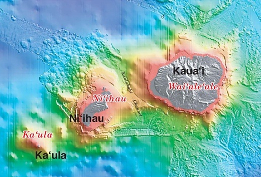
Image above: Detail of seamount map of the Hawaiian islands focusing on Kauai county. Click to enlarge for whole map. From (http://catherinesherman.wordpress.com/2011/03/08/living-at-the-edge-of-a-volcano/).
An Alien Adventure
Let me invite you to a sci-fi thought experiment in the distant future.
This experiment begins millions of years in the future. Aliens have crash landed their spaceship on Earth, in central Eurasia. They have survived with enough gear to maintain their lives and record their discoveries. What to do? Go exploring!
Don't worry about invading aliens taking over and hunting down the humans survivors. This late in the Earth's history the atmosphere has already boiled off along with the oceans.
The aliens look at the geological history. They are searching for signs of past life on Earth. There is little anthropological evidence, but there appear to be a mineral traces of a record of life on the planet.
After working their way thousands of miles east they come to a gigantic desert basin that seems to cover half the world. What to do? Cross it!
The alien troupe work their way across thousands of miles with delays at deep chasms cut into the basin. Finally they see in the distance a tight group of mountains on the horizon.
As they near the mountains they realize that the mountains are the highest they have seen on the planet. Ten-of -thousands of times their own body heights.
When they finally reach the foot of the nearest mountain they realize how steep they are. What to do? Climb!
They leave the flat basin below and take the harrowing climb to the top.
It is only when they reach the top that they can see that all the mountains are exactly the same height above the basin.
There are no pinnacle because the tops of every mountain has been sheared off at the same elevation leaving behind a flat plateau many miles in diameter.
What force could have cut off the tops of all these mountains at the same height?
One alien's eye sparkle before the rest. With words we would not understand he/she utters one word - WATER.
There must have been an abundance of surface liquid water here like we have never seen before; deep enough in miles to reach the very pinnacles of what was here once - ISLANDS.
The Arc of Kauai
An experience in the past about the not so distant future.
In 1972 I attended a lecture at the Lihue Public Library that was given by a University of Hawaii professor of geology.
The presentation was largely made with a slide projector and showed the geological formation of an island from the first undersea mount, through a series of volcanic eruptions that raised the mountain out of the sea. The midpoint of the lecture was the island that today is familiar to us as Kauai.
The next half of the presentation followed the projected future of the island as it eroded back into the ocean, until it became a flat atoll, just a few feet above the waves. That fate will be within the next 2 million years.
From then we'll ride the Pacific tectonic plate northwest as an atoll. In another 65 million years, as a seamount, we'll be sucked under the North American tectonic plate as we meet the Aleutian Islands. Such is fate.
We Are Only Human
What can mere humans do facing the scale of these events? Well, what we are doing is everything we can to hurry things along to reach living on an eroded desert island!
It is water that erodes the island in the form of rainwater and ocean swells.
The rain comes in great quantities on a few areas and courses it way down the landscape cutting away earth a stone. Ultimately, that material is carried to the ocean, not to be returned. That is a natural phenomena, but humans accelerate the erosion by cutting forests, paving over land, and irrigating fields.
The ocean waves come to the island and their violence can be softened by reefs, beaches, dunes and wetlands. Over 70% of our coastline is in retreat, many areas by a few feet every year. A few feet a year is not unusual.
The drama seems only to weigh on us when the ocean spray begins landing on our perimeter highway, as it has at Wailua and Kekaha. As we damage or destroy these fragile places the erosion of Kauai is accelerated.
Just look what the military alone has done to Pearl Harbor on Oahu and what "agriculture" has done to the Mana Plain on Kauai. One was dug out for warships the other filled in for sugar (and now GMO high-fructose corn syrup and the Pacific Missile Range Facility or PMRF). These two areas were the largest wetland systems in the middle of millions of square miles of Pacific Ocean. That domain is now under the control of the US Navy for the purpose of "testing" weapons and "war-games".
The Task at Hand
Restoring the critical cross-sections of ocean to land would allow both fresh and salt water fish and fowl to flourish once again. Let's start with Mana Plain and Pearl Harbor by making them once again extensive brackish wetlands. Restoration of the areas between our reefs and wetlands will help slow the erosion of our shorelines.
Besides protecting and enhancing the health of reefs, beaches, dunes and wetlands in order to protect our shores we can do a great deal to reduce erosion by rainwater as well. This is achieved primarily by slowing the course of water on the land.
There are many techniques for doing this including charging groundwater; holding water in reservoirs; distributed aquaculture; collecting and storing rainwater for residential use; and using water through the principles of organic permaculture.
The key is to slow down the course of the water on the land with uses that are beneficial - beneficial in that they increase life and its diversity. What better task could we have?
.
By Juan Wilson on 16 March 2013 for Island Breath -
(http://islandbreath.blogspot.com/2013/03/eroding-kauai.html)
Image above: Detail of seamount map of the Hawaiian islands focusing on Kauai county. Click to enlarge for whole map. From (http://catherinesherman.wordpress.com/2011/03/08/living-at-the-edge-of-a-volcano/).
An Alien Adventure
Let me invite you to a sci-fi thought experiment in the distant future.
This experiment begins millions of years in the future. Aliens have crash landed their spaceship on Earth, in central Eurasia. They have survived with enough gear to maintain their lives and record their discoveries. What to do? Go exploring!
Don't worry about invading aliens taking over and hunting down the humans survivors. This late in the Earth's history the atmosphere has already boiled off along with the oceans.
The aliens look at the geological history. They are searching for signs of past life on Earth. There is little anthropological evidence, but there appear to be a mineral traces of a record of life on the planet.
After working their way thousands of miles east they come to a gigantic desert basin that seems to cover half the world. What to do? Cross it!
The alien troupe work their way across thousands of miles with delays at deep chasms cut into the basin. Finally they see in the distance a tight group of mountains on the horizon.
As they near the mountains they realize that the mountains are the highest they have seen on the planet. Ten-of -thousands of times their own body heights.
When they finally reach the foot of the nearest mountain they realize how steep they are. What to do? Climb!
They leave the flat basin below and take the harrowing climb to the top.
It is only when they reach the top that they can see that all the mountains are exactly the same height above the basin.
There are no pinnacle because the tops of every mountain has been sheared off at the same elevation leaving behind a flat plateau many miles in diameter.
What force could have cut off the tops of all these mountains at the same height?
One alien's eye sparkle before the rest. With words we would not understand he/she utters one word - WATER.
There must have been an abundance of surface liquid water here like we have never seen before; deep enough in miles to reach the very pinnacles of what was here once - ISLANDS.
The Arc of Kauai
An experience in the past about the not so distant future.
In 1972 I attended a lecture at the Lihue Public Library that was given by a University of Hawaii professor of geology.
The presentation was largely made with a slide projector and showed the geological formation of an island from the first undersea mount, through a series of volcanic eruptions that raised the mountain out of the sea. The midpoint of the lecture was the island that today is familiar to us as Kauai.
The next half of the presentation followed the projected future of the island as it eroded back into the ocean, until it became a flat atoll, just a few feet above the waves. That fate will be within the next 2 million years.
From then we'll ride the Pacific tectonic plate northwest as an atoll. In another 65 million years, as a seamount, we'll be sucked under the North American tectonic plate as we meet the Aleutian Islands. Such is fate.
We Are Only Human
What can mere humans do facing the scale of these events? Well, what we are doing is everything we can to hurry things along to reach living on an eroded desert island!
It is water that erodes the island in the form of rainwater and ocean swells.
The rain comes in great quantities on a few areas and courses it way down the landscape cutting away earth a stone. Ultimately, that material is carried to the ocean, not to be returned. That is a natural phenomena, but humans accelerate the erosion by cutting forests, paving over land, and irrigating fields.
The ocean waves come to the island and their violence can be softened by reefs, beaches, dunes and wetlands. Over 70% of our coastline is in retreat, many areas by a few feet every year. A few feet a year is not unusual.
The drama seems only to weigh on us when the ocean spray begins landing on our perimeter highway, as it has at Wailua and Kekaha. As we damage or destroy these fragile places the erosion of Kauai is accelerated.
Just look what the military alone has done to Pearl Harbor on Oahu and what "agriculture" has done to the Mana Plain on Kauai. One was dug out for warships the other filled in for sugar (and now GMO high-fructose corn syrup and the Pacific Missile Range Facility or PMRF). These two areas were the largest wetland systems in the middle of millions of square miles of Pacific Ocean. That domain is now under the control of the US Navy for the purpose of "testing" weapons and "war-games".
The Task at Hand
Restoring the critical cross-sections of ocean to land would allow both fresh and salt water fish and fowl to flourish once again. Let's start with Mana Plain and Pearl Harbor by making them once again extensive brackish wetlands. Restoration of the areas between our reefs and wetlands will help slow the erosion of our shorelines.
Besides protecting and enhancing the health of reefs, beaches, dunes and wetlands in order to protect our shores we can do a great deal to reduce erosion by rainwater as well. This is achieved primarily by slowing the course of water on the land.
There are many techniques for doing this including charging groundwater; holding water in reservoirs; distributed aquaculture; collecting and storing rainwater for residential use; and using water through the principles of organic permaculture.
The key is to slow down the course of the water on the land with uses that are beneficial - beneficial in that they increase life and its diversity. What better task could we have?
.
No comments :
Post a Comment