Showing posts with label Strategic Islands. Show all posts

Marshall Islanders H-Bomb Victims

SUBHEAD: The Bravo H-bomb test had an unexpected wind shift heavily contaminating many populated atolls.

By Dahr Jamail on 24 October 2018 for TruthOut -
(https://truthout.org/articles/the-us-tested-bombs-on-the-marshall-islands-now-victims-are-seeking-justice/)


Image above: Islanders from nuclear weapons test-damaged Rongelap Atoll march on 1 March 2014 while holding banners marking the 60th anniversary of the Bravo hydrogen bomb test at Bikini Atoll in Majuro. Photo by Isaac Marty.From original article.

A dozen years before Jiji Jally was born in the Marshall Islands, the US conducted the Bravo test, the single largest above-ground nuclear detonation in the world.

The US’s nuclear bomb testing in the Marshall Islands amounted to the equivalent of detonating 1.6 Hiroshima bombs every single day for 12 years. The Bravo test on Bikini Atoll alone was the nuclear equivalent of more than 1,000 Hiroshima-sized bombs.

Jally’s family, like hundreds of others, has lived with the scars of this ever since.

“Everybody I know in the Marshall Islands has stories of cancer in their families,” Jally, who lives in Tumwater, Washington where she works as a court and medical interpreter, told Truthout.

Her brother died in 2012, leaving behind his wife and two young boys. Given that he died in the Marshall Islands, which lacks any facilities to diagnose and treat cancer, the cause of his death is unknown. But Jally explained that he had a tumor, and believes it was from cancer.

“Then my cousin passed a few years ago, who was in her mid-thirties,” she added. “And she died of breast cancer, and left three boys and a girl behind.”

For Jally, working as a medical interpreter highlighted the health care disparity her Marshall Islands community faces, even here in the US. She has therefore become an advocate for their right to health care.

“People from the Marshall Islands are moving out of there looking for healthcare,” Jally said. “But some of them come to Washington and are told they don’t qualify for health insurance or health care.

A Marshallese man in our community is undergoing chemo from his cancer that he got from the bombings, and now he has to stop his chemo because he can’t afford to continue the treatment. It’s really sad to me what we are having to go through just to get health care now, given what happened.”

The injustice of this is not lost on her or on others in her immediate community. However, most Americans have little understanding of what the US government has inflicted on the Marshallese people.

“The Cold War was not ‘cold’ for the Marshallese…it was hot,” Holly Barker, who is a professor at the University of Washington and a commissioner on the Republic of Marshall Islands National Nuclear Commission (a three-person commission with the goal of advancing nuclear justice for the Marshallese people), told Truthout.
“‘Cold’ communicates the privilege of being far from the testing locations and not having to live with firsthand experiences with nuclear weapons.”
President Donald Trump recently announced plans to remove the US from the Intermediate-Range Nuclear Forces (INF) Treaty with Russia, a move which many fear could ignite a new nuclear arms race. The INF had banned all short and mid-rang nuclear and non-nuclear missiles, and helped to eliminate thousands of land-based missiles. Trump has also promised to build new nuclear weapons.

As a deadly reminder of the lingering health impacts from nuclear weapons testing during the Cold War, untold numbers of Marshall Islands residents continue to seek healthcare, and justice, for having unwittingly been made human test subjects to nuclear tests.

According to Barker, multiple types of cancer continue to beset the Marshallese. Adequate healthcare might be a first step toward justice – but so far, that step is far from realized.

Marshall Islands' Cancer Rate "Extreme"
In 1947 the US made an agreement with the UN to create a strategic trusteeship territory across islands of Micronesia, an area covering three million square miles comprised of two thousand islands.

Just five days after obtaining the agreement with the UN, the US Atomic Energy Commission established what it called the Pacific Proving Grounds and shortly thereafter began testing nuclear weapons in the atmosphere and underwater across the region.

One-hundred-and-six tests over a dozen years were conducted, many of them extremely high yield. While the Marshall Islands testing were only 14% of all US nuclear tests, they comprised nearly 80% of the total nuclear yields detonated by the US.

Many Marshall Islands residents were exposed to radiation and nuclear fallout, and many of the islands remain contaminated to this day. Through the Radiation Exposure Compensation Act of 1990, money was paid to the Marshal Islanders as compensation for their exposure to the testing, but generations later the problem persists.

There are no exact numbers regarding how many people across the Marshall Islands were impacted, directly or indirectly, by the nuclear tests. Although the US government — like the governments of so many colonial powers — has minimized the consequences of its testing, its effects continue to this day.

“Does ‘affected’ mean those exposed to radioactive fallout, those whose land was vaporized and no longer exists on this planet?” Barker asked. “Is it people whose land will be contaminated for thousands of years into the future, is it the people whose chromosomes/DNA are mutated by the mutagenic properties of radiation?”

Barker, who has been studying the plight of the Marshallese for decades, admits that coming up with exact numbers is difficult and the numbers remain unknown.

“It is difficult because it plays into US efforts to minimize the numbers of people and islands whose health and land were damaged and injured by the testing program,” she said. “It is not just health and environmental damage, however. The political system was altered, the culture, the economy, and the language, among other things.”

In the late 1990s, a study published in Cancer, the journal of the American Cancer Society, found that cancer rates in the Marshall Islands, caused by the combination of exposure to nuclear test fallout, malnutrition, and other factors associated with the rapid westernization of their society, were “alarming,” according to the study.

Neal Palafox with the University of Hawaii’s John A. Burns Medical School, who authored the study along with four colleagues, told the media at the time the study was released that the incidence of cancer in the Marshall Islands was “extreme.”

The study compared the rate of various cancers found in the Marshallese to rates in the US. “Cancer incidence rates were higher in virtually every category in the Marshall Islands compared with the United States for the period 1985-1994,” the study said.

As just one example, the study found liver cancer rates in the Islands to be 15 times higher in males and 40 times higher in females compared to rates for those cancers in the US.

The study referenced the 67 nuclear tests conducted across the islands, and added that “increases in leukemia, breast cancer and thyroid cancer after radiation exposure have been well established, especially in childhood exposures.”
 
Erasing History
Rachael Hoffman, a Marshallese woman living in Everett, Washington, works with Barker in educating the public and younger generations about what the US government did in the Marshall Islands.

Every year she helps organize a Remembrance Day ceremony marking the March 1, 1954, detonation of the Bravo Bomb.

Her grandmother developed thyroid cancer that she attributes to the nuclear tests, and received some compensation from the government for it. With that money, she was able to move to the US, along with some of her relatives, during the 1980s.

“67 nuclear bombs were tested in the Marshall Islands in a 12-year span,” Hoffman told Truthout. “People were relocated from island to island, and to this day people remain displaced from nuclear testing.”

Hoffman discussed how the rapid westernization of the culture led to a poor diet taking a toll on the health of the Marshallese.

“During the testing a lot of the food was imported because people were overcrowded on these islands they were relocated to,” she explained. “The crops and fish were poisoned, so people couldn’t eat off the land, so they had to rely on canned food which caused high blood pressure, high cholesterol and diabetes.”

There were four main coral atolls of the Marshall Islands that were primarily impacted, and the people living on those have the highest numbers of cancer cases.

“These are the people who own the nuclear story because they are the ones facing the radiation directed illnesses and diseases and death that has come from all of this,” Hoffman said.

Today she works towards engaging younger people in the Marshallese community, both in the US and on the islands, “so they can know their story, know their history, otherwise that story will be lost.”

Hoffman said that is one of the main reasons she works annually to organize the Remembrance Day, so that these stories are not lost.

“The young people have no idea how bad the nuclear testing was that was done to our people,” Hoffman said, “because it’s definitely not taught in schools.”

Lack of Care
In the Marshall Islands, there is practically no medical diagnostic ability, no forensics, and not even an oncologist, according to Jally, Hoffman and Barker. This makes it challenging to find accurate numbers of cancer incidence.

“We know that many people died on the outer islands, for instance, with symptoms that sound like cancer,” Barker said. “Thyroid cancer, cervical cancer, breast cancer, lung cancer, colon cancer are all issues.”

Thomas Hamilton is an endocrinologist and thyroid disease specialist who did groundbreaking research on the impacts of the nuclear testing on the Marshall Islands community.

In a 1991 report he produced for Physicians for Social Responsibility, Hamilton stated, “The testing of nuclear weapons on these islands…has had profound direct and indirect effects on the health of the Marshall Islands residents as well as on their environment and culture.”

Hamilton concluded that the initial exposure of the Marshallese from the 1954 Bravo test “could probably have been prevented entirely or significantly reduced” by evacuating the residents prior to the test, as had been done prior to other tests; evacuating them immediately after the test; or at least postponing the detonation for when it was known the winds would not bring the fallout atop the Marshallese people.

The report points out that additional exposure could have been prevented by postponing the return of people who had been evacuated to the islands, or evacuating them again “when it was known that their body burdens of radionuclides were steadily increasing.”

Needless to say, the just, humanitarian and ethical thing for the US government to do would have been not to conduct nuclear testing in the region in the first place, let alone in an area where people lived.

The report was also critical of the US Department of Energy’s studies of the health impacts of the nuclear tests on the Marshallese, saying the DOE’s studies had “significant limitations.”

Hamilton told Truthout that his work studying the health impacts on the Marshallese from the nuclear tests “was not welcomed by the US government,” and pointed to the fact that as recently as 2013 a government study on the topic went to great lengths to invalidate the results of some his work.

While it has now been decades since Hamilton was deeply engaged in his studies of the testing’s health impacts on the Marshallese, he told Truthout that the findings of one of his studies, published in 1987, showed that the nuclear fallout went “quite a bit further” than the DOE had acknowledged.

“The Bravo test had an unexpected wind shift that caused heavy contamination in many atolls, but certainly on Rongelap Island, so those folks were allowed to stay where the fallout, which was like snow on the ground and kids were playing in it,” Hamilton said. “And it was two to three days before those people were evacuated.”

Hamilton added, “I was surprised in 2013 that they [US Government] mentioned my study, so they are somehow still concerned there’s an article out there saying their studies weren’t as complete as they should be.”

Meanwhile, Barker argues that, since the Marshall Islands was a US territory when the testing occurred, the Marshallese deserve the same standard of cancer care as Americans (at least those who can afford decent health insurance).

“But as it is, people have to leave the country and all that is familiar and comfortable to them at the time when they need the most support and comfort,” Barker said.

Meanwhile, like so many other Marshallese, Jally struggles to live with what was done to her people.

“I grew up there not knowing the history of our country,” she said. “I graduated high school and became a parent and didn’t really know the history until I started working with the community as a medical interpreter.”

Jally explained that her elders have spoken very emotionally of the bombings, telling her, “Yes, that happened to us and we lived through it.”

“The old folks watch these films about what happened and they tear up, and a lot of their families have died from cancer or because they are diabetic,” she concluded. “There is a lot of trauma in our community from this.”

.

Puerto Rico's new hurricane season

SUBHEAD: Puerto Ricans remember inequalities of race, income, and access to U.S. political power.

By Basav Sen on 5 July 2018 for Foreign Policy in Focus -
(https://fpif.org/puerto-rico-confronts-a-new-hurricane-season-and-old-injustices/)


Image above: A couple stare at the destruction of hurricane Maria on where they lived. From original article.

[IB Publisher's note: This article underlines the risks to Hawaii. Hawaii is another colonial prize of American expansion into empire. Like Hawaii the island people of Puerto Rico are American citizens. However, they have resisted the invitation of statehood. They have three options - one is remain a commonwealth under US control - another is they could to push for true independence and sovereignty - another is to vote for US statehood. Seeing what tourism, big Ag and suburbanization has done to Hawaii, and seeing how Puerto Rico has been treated after hurricane Maria (Trump tossing paper towel rolls to storm victims) my advice is that Puerto Rico should push for sovereign independence. And so should we.]

The disastrous impacts of Hurricane Maria were made by inequalities of race, income, and access to U.S. political power.

Residents of Puerto Rico are confronting the prospect of a fresh hurricane season, which will likely bring five to nine hurricanes, including one to four major hurricanes. The island, badly battered by last year’s Hurricane Maria, still hasn’t recovered. We continue to learn more about how dire the disaster has been.

A recent academic study showed that the death toll from Maria was likely about 4,700 — or more than 70 times the “official” count of 64. This was no mere “natural” disaster. The impacts of Hurricane Maria were to a large extent attributable to inequalities of race, income and — critically — access to political power.

The majority of deaths in Puerto Rico weren’t from people being hit by flying debris or drowning in floods. The largest number of deaths occurred because hospitals and clinics lost power, rendering them unable to provide treatment to critically ill patients. Others died because water treatment facilities shut down, increasing the risk of potentially fatal waterborne diseases.

This situation persisted for unacceptably long. Only 43 percent of the island’s residents had access to electricity even two months after the hurricane—barely half the global average. That’s on par with the 41 percent share in Benin, and considerably less than the 76 percent share in Bangladesh.

In one of the wealthiest countries in the world, then, access to electricity fell to the level of some of the world’s poorest countries. Even today, thousands of Puerto Ricans remain without electricity.

Puerto Rico is a 99 percent Latinx island. Its 43.5 percent poverty rate is nearly 3.5 times the national average, and its median household income is barely one-third of the U.S. median. Can we stop pretending these facts had nothing to do with the scale of the disaster and the inept official response to it?

Turns out, it wasn’t just the aftermath of the storm, but what came before.

The delay in restoring electricity was partly because the island’s grid hadn’t been maintained over a decade-long recession—a crisis worsened by Washington-imposed austerity policies that prioritize loan repayments over the needs of Puerto Ricans. The hurricane “lifted the veil on the pre-existing crisis,” says Jesús Vázquez of Organización Boricuá, a Puerto Rican food sovereignty organization. “But we knew it was there, because we were living it constantly.”

Puerto Rico is effectively a U.S. colony, with no representation in Congress. Philip Alston, the UN’s Special Rapporteur on Extreme Poverty who recently toured the United States, explicitly linked the territory’s economic and environmental devastation to its colonial status. “Political rights and poverty are inextricably linked in Puerto Rico,” he said. “In a country that likes to see itself as the oldest democracy in the world and a staunch defender of political rights on the international stage, more than 3 million people who live on the island have no power in their own capital.”

This isn’t the first time the UN has paid attention to U.S. colonialism in Puerto Rico, either. It holds hearings on decolonization of Puerto Rico every year and produces lengthy reports. The United States doesn’t bother to attend the hearings, blowing one off as recently as this month.

What of the storm itself? The intensity and frequency of hurricanes are increasing because our economy’s addiction to burning coal, oil, and gas is warming our world. Scientists have warned about this for decades, but our political leadership has failed to act.

Every activity of the fossil fuel industry — production, transportation, processing, combustion and waste disposal — is dirty and dangerous. Exposure to these hazards and their consequences fall across striking race and income disparities everywhere in the U.S. and worldwide.

It’s a problem that infects the mainland, too. From residents of the 95 percent Black town of Port Arthur, Texas, who confront extraordinarily high cancer rates because of oil refinery pollution, to the Indigenous Alaskan villages at risk of disappearing because of sea level rise, poor people and people of color disproportionately bear the costs of our unhealthy addiction to fossil fuels. And the consequences of climate change are expected to make poverty and inequality worse.

Our unequal political system places greater value on the profits of polluters than on the basic needs, or even the lives, of most of humanity. Our political leadership gets away with this immoral calculus because of the systematic disenfranchisement of vulnerable people at the bottom and legally sanctioned bribery at the top.

This vicious cycle — in which racial, economic, and other forms of inequality are both a cause and a consequence of environmental devastation — needs to be broken with powerful movements that confront the systemic roots of these inequalities.

The great news is that these movements are happening. People in Puerto Rico and in the Puerto Rican diaspora in places like New York have been demanding a just recovery led by Puerto Ricans and for the benefit of all Puerto Ricans, and working to build community resilience from the ground up.

Here on the mainland, affected communities including Indigenous peoples are at the forefront of resistance to polluting fossil fuel infrastructure in Minnesota, Louisiana, and elsewhere. Indeed, shortly after the latest death toll figures in Puerto Rico were released, thousands marched on state capitals across the country, demanding solutions to poverty and environmental justice as part of the new Poor People’s Campaign.

For Puerto Ricans bracing themselves for more storms and blackouts this summer, Pacific Islanders watching rising seas drowning their homelands, and countless other marginalized peoples in the United States and worldwide paying the price for our dirty energy and economic systems, these movements couldn’t come sooner.

In the Murk

SUBHEAD: Puerto Rico is back in the 18th Century, minus the practical skills for living that way of life.

By James Kunstler on 22 September 2017 for Kunstler.com -
(http://kunstler.com/clusterfuck-nation/in-the-murk/)


Image above: Before dawn a police car patrols as the hurricane hits in Fajardo, in northeast Puerto Rico. From (https://www.nbcnews.com/slideshow/hurricane-maria-lashes-storm-battered-caribbean-n802936).

Welcome to America’s first experiment in the World Made By Hand lifestyle. Where else is it going? Watch closely.

Ricardo Ramos, the director of the beleaguered, government-owned Puerto Rico Electric Power Authority, told CNN Thursday that the island’s power infrastructure had been basically “destroyed” and will take months to come back

“Basically destroyed.” That’s about as basic as it gets civilization-wise.

Residents, Mr. Ramos said, would need to change the way they cook and cool off. For entertainment, old-school would be the best approach, he said. “It’s a good time for dads to buy a ball and a glove and change the way you entertain your children.”

Meaning, I guess, no more playing Resident Evil 7: Biohazard on-screen because you’ll be living it — though one wonders where will the money come from to buy the ball and glove? Few Puerto Ricans will be going to work with the power off.

And the island’s public finances were in disarray sufficient to drive it into federal court last May to set in motion a legal receivership that amounted to bankruptcy in all but name. The commonwealth, a US territory, was in default for $74 billion in bonded debt, plus another $49 billion in unfunded pension obligations.

So, Puerto Rico already faced a crisis pre-Hurricane Maria, with its dodgy electric grid and crumbling infrastructure: roads, bridges, water and sewage systems. Bankruptcy put it in a poor position to issue new bonds for public works which are generally paid for with public borrowing.

Who, exactly, would buy the new bonds? I hear readers whispering, “the Federal Reserve.” Which is a pretty good clue to understanding the circle-jerk that American finance has become.

Some sort of bailout is unavoidable, though President Trump tweeted “No Bailout for Puerto Rico” after the May bankruptcy proceeding. Things have changed and the shelf-life of Trumpian tweets is famously brief.

But the crisis may actually strain the ability of the federal government to pretend it can cover the cost of every calamity that strikes the nation — at least not without casting doubt on the soundness of the dollar.

And not a few bonafide states are also whirling around the bankruptcy drain: Illinois, Connecticut, New Jersey, Kentucky.


Image above: In daylight electricity poles and lines lay toppled on the road in Humacao in southeast  Puerto Rica. From (https://www.nbcnews.com/slideshow/hurricane-maria-lashes-storm-battered-caribbean-n802936).

Constitutionally states are not permitted to declare bankruptcy, though counties and municipalities can. Congress would have to change the law to allow it. But states can default on their bonds and other obligations. Surely there would be some kind of fiscal and political hell to pay if they go that route.

Nobody really knows what might happen in a state as big and complex as Illinois, which has been paying its way for decades by borrowing from the future. Suddenly, the future is here and nobody has a plan for it.

The case for the federal government is not so different. It, too, only manages to pay its bondholders via bookkeeping hocuspocus, and its colossal unfunded obligations for social security and Medicare make Illinois’ predicament look like a skipped car payment.

In the meantime — and it looks like it’s going to be a long meantime — Puerto Rico is back in the 18th Century, minus the practical skills and simpler furnishings for living that way of life, and with a population many times beyond the carrying capacity of the island in that era.

For instance, how many houses get their water from cisterns designed to catch rain runoff? How many communities across the island are walkable? (It looks like the gas stations will be down for quite a while.)

I’ve been there and much of the island is as suburbanized as New Jersey — thanks to the desire to be up-to-date with the mainland, and the willingness of officials to make it look like that.

We’re only two days past the Hurricane Maria’s direct hit on Puerto Rico and there is no phone communication across the island, so we barely know what has happened.

We’re weeks past Hurricanes Irma and Harvey, and news of the consequences from those two events has strangely fallen out of the news media. Where have the people gone who lost everything?

The news blackout is as complete and strange as the darkness that has descended on Puerto Rico.

.

Civil Beat views US military in Pacific

SUBHEAD: Will a military buildup in far-flung Pacific island territories destroy their unique environment?

By Juan Wilson on 20 August 2017 for Island Breath -
(http://islandbreath.blogspot.com/2017/08/civil-beat-views-us-military-in-pacific.html)


Image above: Phboto of WWII military plane wreck on Pagan Island. the island is now to be used by American forces for target practice. (http://www.civilbeat.org/2016/12/can-these-islands-survive-americas-military-pivot-to-asia/).

Civil Beat is a Hawaiian news agency that has done an excellent job in investigating a wide range of interests throughout the Hawaiian Islands. It stands head and shoulders above the pathetic efforts of the Garden Island News (owned by the Honolulu Star-Advertiser which is owned by a Canadian corporation Black Press).

Civil Beat is a 501(c)3 tax-exempt news organization dedicated to cultivating an informed body of citizens, all striving to make Hawaii a better place. It uses local reporters and covers local, national and international issues. It is one of the few online news sites IslandBreath supports with donations.

Civil Beat has made an important contribution to a better understanding of American military domination in the Pacific. That imperial effort goes back to the Spanish American War and the takeover of Hawaii and continues to this day. 

Civil Beat has put together several articles in one place called Outpost Pacific (http://www.civilbeat.org/projects/pacific-outpost/) covering issues on the Mariana Islands with specific pieces on Pagan Island, Tinian Island, Guam and Farallon de Medinilla.

Already plans for  RIMPAC 2018 are racing ahead. Those are the Rim of the Pacific war games conducted by the US Navy every even numbered year in and around Hawaii that includes more than a dozen navies.

Kauai's Pacific Missile Range Facility (PMRF) and Makaha Ridge Tracking Facility play a large part in those war games and any real war in the Pacific. That makes Kauai, and those other strategic islands occupied by the US military ground zero for any major conflict involving China, North Korea or Russia.

See:
Civil Beat Chapter 1: Can These Islands Survive America’s Military Pivot To Asia?
Civil Beat Chapter 2: The Fight To Save Pagan Island From US Bombs
Civil Beat Chapter 3: Tinian - "We believed in America"
Civil Beat Chapter 4: Guam - Many In This Military Outpost Welcome More Troops
Civil Beat Chapter 5: Missing Data Plagues Military Training Plans In The Marianas

See also:

Ea O Ka Aina: South Korea's stubborn Peace Effort 8/4/17
Ea O Ka Aina: "No!" to America Militrarism in Hawaii 4/11/17
Ea O Ka Aina: Air Force plans to bomb whales 2/6/17
Ea O Ka Aina: MV-22 Osprey landing at Salt Pond 2/5/17
Ea O Ka Aina: Kauai and Niihau endangered 9/24/16 
Ea O Ka Aina: DLNR responsibility on RIMPAC 7/6/16
Ea O Ka Aina: Oceans4Peace Pacific Pivot Panel 6/18/16
Ea O Ka Aina: Ocean 4 Peace Events 6/11/16
Ea O Ka Aina: Prepare for RIMPAC 2016 War in Hawaii 5/22/16
Ea O Ka Aina: Navy to "take" millions of mammals 5/17/16
Ea O Ka Aina: US court RIMPAC Impact decision 4/3/15
Ea O Ka Aina: RIMPAC 2014 Impact Postmortem 10/22/1
Ea O Ka Aina: Marines backing off 8/24/12
Ea O Ka Aina: Unproved Osprey on Kauai 8/21/12
Ea O Ka Aina: RIMPAC 2014 in Full March 7/16/14
Ea O Ka Aina: 21st Century Energy Wars 7/10/14
Ea O Ka Aina: RIMPAC War on the Ocean 7/3/14
Ea O Ka Aina: Voila - World War Three 7/1/14
Ea O Ka Aina: The Pacific Pivot 6/28/14
Ea O Ka Aina: RIMPAC IMPACT 6/8/14
Ea O Ka Aina: RIMPAC Then and Now 5/16/14
Ea O Ka Aina: Earthday TPP Fukushima RIMPAC 4/22/14
Ea O Ka Aina: The Asian Pivot - An ugly dance 12/5/13
Ea O Ka Aina: Help save Mariana Islands 11/13/13
Ea O Ka Aina: End RimPac destruction of Pacific 11/1/13 
Ea O Ka Aina: Moana Nui Confereence 11/1/13
Ea O Ka Aina: Navy to conquer Marianas again  9/3/13
Ea O Ka Aina: Pagan Island beauty threatened 10/26/13
Ea O Ka Aina: Navy license to kill 10/27/12 
Ea O Ka Aina: Sleepwalking through destruction 7/16/12
Ea O Ka Aina: Okinawa breathes easier 4/27/12
Ea O Ka Aina: Navy Next-War-Itis 4/13/12
Ea O Ka Aina: America bullies Koreans 4/13/12
Ea O Ka Aina: Despoiling Jeju island coast begins 3/7/12
Ea O Ka Aina: Jeju Islanders protests Navy Base 2/29/12
Ea O Ka Aina: Hawaii - Start of American Empire 2/26/12
Ea O Ka Aina: Korean Island of Peace 2/26/12   
Ea O Ka Aina: Military schmoozes Guam & Hawaii 3/17/11
Ea O Ka Aina: In Search of Real Security - One 8/31/10
Ea O Ka Aina: Peace for the Blue Continent 8/10/10
Ea O Ka Aina: Shift in Pacific Power Balance 8/5/10
Ea O Ka Aina: RimPac to expand activities 6/29/10
Ea O Ka Aina: RIMPAC War Games here in July 6/20/10
Ea O Ka Aina: Pacific Resistance to U.S. Military 5/24/10
Ea O Ka Aina: De-colonizing the Pacific 5/21/10
Ea O Ka Aina: RIMPAC to Return in 2010 5/2/10
Ea O Ka Aina: Living at the Tip of the Spear 4/5/10
Ea O Ka Aina: Living at the Tip of the Spear 4/15/10
Ea O Ka Aina: Guam Land Grab 11/30/09
Ea O Ka Aina: Guam as a modern Bikini Atoll 12/25/09
Ea O Ka Aina: GUAM - Another Strategic Island 11/8/09
Ea O Ka Aina: Diego Garcia - Another stolen island 11/6/09
Ea O Ka Aina: DARPA & Super-Cavitation on Kauai 3/24/09
Island Breath: RIMPAC 2008 - Navy fired up in Hawaii 7/2/08
Island Breath: RIMPAC 2008 uses destructive sonar 4/22/08
Island Breath: Navy Plans for the Pacific 9/3/07
Island Breath: Judge restricts sonar off California 08/07/07
Island Breath: RIMPAC 2006 sonar compromise 7/9/06
Island Breath: RIMPAC 2006 - Impact on Ocean 5/23/06
Island Breath: RIMPAC 2004 - Whale strandings on Kauai 9/2/04
Island Breath: PMRF Land Grab 3/15/04 


.

South Korea's stubborn peace effort

SUBHEAD: Peace movement refusing to give up is taking the long view of its campaign. 

By Jon Letman on 4 August 2017 for Truth Out -
(http://www.truth-out.org/news/item/41486-taking-the-long-view-why-south-korea-s-peace-movement-refuses-to-give-up)


Image above: Jeong Young-hee is a Korean tangerine farmer in Gangjeong village on Jeju island. Like many residents, she strongly opposes the newly built South Korean naval base just two miles from her farm. Photo by Jon Letman. From original article.

In August, 1945, as Japan smoldered in the ruins of war, the question of what would become of the Korean peninsula after 35 years of Japanese occupation and a Soviet army advancing southward spurred the hasty selection of an artificial division along the 38th parallel drawn by two American officials as a border between US and Soviet "zones of occupation."

That line, never intended to be permanent, hardened like stubborn mud before the newly liberated Korea ever had the chance to form an independent, unified and democratic nation. Today 38°N still marks a potentially catastrophic flashpoint between North and South Korea.

The DMZ -- demilitarized zone -- despite its name, is one of the most militarized places on the planet. This hyper-militarization, in fact, extends south across the peninsula and today, 64 years after an armistice halted (but never formally ended) the Korean war, South Korea remains peppered with scores of US military installations -- at least 80 by the Pentagon's own count.

US bases, and the 28,500 US troops and joint military exercises they support, are not only opposed by North Korea; many South Koreans see them as a problematic construct that perpetuates the likelihood of war.

Despite frequent media coverage of North Korea's highly choreographed military parades, increasing missile launches, and Kim Jong-un's threats to turn Seoul into a "sea of fire," far less attention is paid to South Korea's tireless, well-organized peace movement opposed to militarism on both sides of the DMZ.

South Korean civil groups and NGOs like People's Solidarity for Participatory Democracy and the Korean Confederation of Trade Unions are skilled at forming coalitions with peace activists and religious groups opposed to a military buildup, which they see as increasing tensions with the North and militarization across Northeast Asia.

Your Old Farm Is Our New Base


Image above: Candle light protests have been held outside the Seongju County office nightly since the deployment of the THAAD antimissile defense system was announced in July 2016. Photo by John Letman. From original article.

With the bulk of US bases concentrated in and around Seoul and within range of North Korean artillery, the US is in the middle of a major realignment of its forces as it consolidates bases, moving tens of thousands of troops, their families and civilian contractors to US Army Garrison Humphreys in the city of Pyeongtaek, 40 miles south of Seoul.

In 2002, when the US announced its plan to triple Humphreys in size, Pyeongtaek residents living around the base organized fierce protests that raged for five years.

Thousands of police were deployed, citizens were arrested and villages were demolished. In the end, however, the base's walls were pushed outward, and Camp Humphreys grew from just over 1,000 acres to more than 3,400 acres, making it the US's largest overseas military base in the world.

Now in the final years of construction, US Army Garrison Humphreys is equipped to serve as the new headquarters for the Eighth US Army and US Forces Korea command center.


Image above: A representative of the Korean Confederation of Trade Unions holds an anti-THAAD banner at a demonstration in Soseong-ri, Seongju County, South Korea. Photo by John Letman. From original article.

The Humphreys expansion is slated for completion by 2020 and will eventually be home to up to 46,000 military and civilian personnel living and working behind razor wire-topped walls and gates.

The $10.7 billion expansion, the US's largest-ever peacetime military construction project, is being paid for overwhelmingly (around 90 percent) by the South Korean government. In 2016, Gen. Vincent Brooks (now head of US Forces Korea) publicly stated that it's cheaper to station US troops in South Korea than in the United States.

The Humphreys expansion does have supporters in the community, and many businesses have come to depend on the US military's presence.

Pyeongtaek's city government, unable to refuse the influx of thousands of US forces, has done its best to promote Humphreys' expansion as an opportunity to court non-military business and infrastructure investment and push for internationalization through increased cultural exchanges with military personnel and their families.

Still, many residents view the base as an unwelcome intrusion on Korean sovereignty and a source of crime, pollution and noise from military aircraft like F-16s, A-10 Thunderbolts, Chinook and Apache helicopters.


Image above: Demonstrators march toward the former golf course in Seongju County where the controversial THAAD antimissile defense system is being deployed by the US. Photo by John Letman. From original article.

Since 2002, Kang Song-won of the Pyeongtaek Peace Center has been working closely with residents from communities affected by Humphreys, particularly those who were forcibly relocated from the villages of Daechu-ri and Dodu-ri. Kang works with volunteers to monitor military incidents and accidents around the base.

Beyond the noise and inherent danger, he told Truthout the most harmful impact of Humphreys' expansion has been the deep divisions sown in the community between base supporters and opponents.

Giving up, however, is not an option. "Even though we lost the fight against the US military, I think it is still necessary to keep fighting ... against the problems of the US military base," Kang said.

Island of Peace, Tides of War


Image above: US Army Garrison Humphreys is a helicopter base in what will soon be the the United States' largest overseas military base. Just beyond the fence are small farming villages. Photo by John Letman. From original article.

An hour's flight south of Seoul is sub-tropical Jeju island. Home to nine UNESCO Global Geoparks and a World Heritage site, the volcanic island is renowned for its natural beauty and biodiversity both on land and sea. Jeju has also been heavily developed for tourism. On the south coast, in Gangjeong village, is the site of a new Korean naval base.

Muddying its primary purpose, the base is sometimes called the Jeju Multipurpose Port Complex and is touted as having a (future) dual civilian-military function, but for now it's strictly a Korean naval base and headquarters for the South Korean Navy's Mobile Task Force Flotilla-7, which includes Aegis warfare destroyers, KDX III helicopter destroyers and a submarine force command.

Like the expansion of Camp Humphreys, the 2007 announcement of the Jeju naval base sparked widespread outcry from residents opposed to the militarization of what was dubbed "Island of Peace" in recognition of Jeju's horrific April 3 massacre (1947-54).

In that massacre, as many as 30,000 island residents were killed by Korean forces over a seven-year period beginning in 1947 during the US military administration that occupied the southern part of the Korean peninsula immediately after the August 1945 defeat of Japan.

As in Pyeongtaek, Jeju base protesters clashed with the police for years. Base opponents, including the former mayor, were arrested and heavily fined but in the end, the base was built.


Image above: Many of the residents protesting against the deployment of the THAAD antimissile defense system are elderly farmers who don't want their remote mountain village to be militarized. Photo by John Letman. From original article.

Tangerine farmers Jeong Young-hee and her husband Kang Sung-won have been growing Jeju's famous citrus varieties for 30 years in greenhouses less than two miles from the base. Young-hee and Sung-won are concerned about the environmental impact of the base, especially the effects on the sea -- including soft corals, sea urchins, abalone and other marine life -- and the destruction of what was a sacred lava rock coastal field called Gureombi.

Construction on the base is not yet complete. Young-hee and Sung-won worry that as it grows, if a future exclusion zone (a zone that would restrict new construction) is declared, it would surround their farm, almost certainly driving down land values.

Peeling one of her sweet hallabong oranges, Young-hee explains how the base has caused a rift between friends and family members. The base has also divided many citrus farmers and Jeju's famous Haenyeo free divers. "Our relationship was destroyed," says Young-hee, who joined her male counterparts in shaving her head as a gesture of protest against the base.


Image above: Retired Catholic priest Father Mun Jeong-hyeon holds a daily mass along along a roadside site that doubles as a protest against the Jeju naval base in Gangjeong village, Jeju island. Photo by John Letman. From original article.

In the early days of the struggle, when base opponents pointed fingers at the US accusing it of pressuring South Korea (also known as the Republic of Korea), South Korean officials denied that the base would permanently host US warships.

This year, in March and June, US warships made their first visits to the Jeju base with short, inconspicuous port calls similar to what was recommended in a 2013 US Army War College strategy research project. Last January, US Pacific Command's Adm. Harry Harris suggested the possibility of deploying the US's newest, most lethal stealth destroyer, the USS Zumwalt to Jeju waters.

The Jeju navy base became operational in February 2016. Resistance continues daily, with activists gathering each morning in front of the entry gate to perform one hundred bows as a nonviolent, meditative protest.

Nearby, in a roadside tent chapel, retired Catholic priest Father Mun Jeong-hyeon leads a daily mass, before joining protesters who gather with flags and banners playing raucous music outside the base.

The mood of the protesters is defiant and the message is serious: they want a shift away from militarization of the Korean peninsula and northeast Asia.

This week (July 30-August 5), for the eighth year since 2008, apeace march is underway, in which activists are walking from the Jeju naval base around the island to raise awareness of the continuing struggle and to call for peace.

In Defense of Who?


Image above: Guards look out from behind a razor wire fence surrounded the new South Korean naval base on Jeju island, South Korea. Photo by John Letman. From original article.

South Korea's latest struggle against militarization began in July 2016 in rural, traditionally conservative Seongju County 135 miles south of Seoul.

Residents of Seongju and neighboring Gimcheon were caught off guard when the central government, under deposed President Park Geun-hye, offered Seongju to the US as a location for the US antimissile defense Terminal High Altitude Area Defense (THAAD) system.

For more than a year since that announcement, daily protests have been taking place in Seongju and elsewhere around the country. In June, an anti-THAAD protest of several thousand people briefly and peacefully surrounded the US embassy in Seoul.

THAAD manufacturer Lockheed Martin says the system is intended to defend "US troops, allied forces, population centers and critical infrastructure against short and medium range ballistic missiles."

Seongju residents and Koreans across the country, however, recite a litany of reasons they are opposed to THAAD, from environmental and health concerns to the lack of a democratic process to ever-increasing deployment of foreign weapons, as well as economic repercussions and tension with its neighbors China and Russia.


Image above: Korean Army personnel stand guard at the Demilitarized Zone/Joint Security Area outside the Military Armistice Commission buildings along the tense border. Photo by John Letman. From original article.

Two weeks before South Korea's snap election on May 9 this year, the US, citing North Korean threats, hurriedly began the deployment of THAAD in what had been a golf course outside a small village called Soseong-ri.

When South Korea's newly elected President Moon Jae-in learned that his own Ministry of Defense had failed to notify him of the presence of an additional four THAAD launchers, Moon called for a temporary suspension of THAAD to conduct an environmental assessment.

That suspension, however, is being reevaluated now as South Korea considers deploying additional launchers in response to a North Korean intercontinental ballistic missile test last week.

Like other aspects of the military alliance between the US and South Korea, THAAD is supported by some South Koreans and reviled by others. And like the communities in Gangjeong village on Jeju and Pyeongtaek near Seoul, the people of Seongju and Gimcheon are divided.

Speaking at a candlelight vigil outside the Seongju County government office on May 30, three local women were eager to share their thoughts with Americans.

On this 310th day of consecutive protests, the women told Truthout they wanted their lives back the way they were before THAAD.

They said their community was being torn apart -- even relations between parents and children were being strained by strong disagreements over THAAD.

Some of their neighbors have given up opposition to THAAD, either accepting it as unavoidable or simply focusing on other matters.

These women, however, refuse to give up and say they feel a responsibility to attend nightly demonstrations against THAAD. They also admit feeling a growing resentment toward what they see as an unequal alliance.

"We are starting to have anti-American sentiments even though we don't hate Americans," a woman who identified herself as Mrs. Kim said.

"To be honest, I want the US military to go home," said a second woman, who also goes by the name Mrs. Kim, adding the English phrase, "Yankee, go home."

The Truth Is Very Powerful


Image above: Demonstrators perform 100 bows for peace six days a week as a protest against the South Korean Jeju naval base in Gangjeong village, Jeju island. Photo by John Letman. From original article.

Even as new bases are built, old bases expanded and more weapons imported, what fuels South Korean peace movements in the face of overwhelming power?

In Seoul, Jungmin Choi who works with Durebang (My Sister's Place), an NGO that provides counseling to foreign women working in bars and clubs near US bases, says those women are living witnesses to the impact of military bases.

Choi calls the impacts of the bases "indescribably huge" and both tangible and intangible, but insists, "we believe this fight cannot be defeated … we will fight in a creative way with a long-term view."

On the other side of the country, Jeju base opponent Choi Sung-hee says that even though the Jeju base is operational and US warships have started visiting, the protests must continue.

Not only does the military know it is being watched, but protests build solidarity with other anti-base movements across South Korea and internationally, in places like Okinawa, Guam, the Philippines and Hawaii, particularly among women.


Image above: A protester is blocked by a security guard as he sits in silent protest outside the entry to the South Korean naval base on Jeju island. Photo by John Letman. From original article.

"That's the role of people ... we should constantly demand: we do not need arms, we do not need THAAD, we do not need more military bases," Choi says. "If the people's movement is strong, I think it can also influence the decisions of the South Korean president."

Nearby, in the St. Francis Peace Center, Father Mun carves messages of peace into wooden boards after each morning's protest. Nearly 80 years old, Father Mun has been a peace activist for decades in Pyeongtaek, on Jeju and elsewhere acting, in his words, as "a witness for truth."

When asked why he continues to resist in the face of overwhelming power, Father Mun declared, "The truth cannot be thrown away. The truth will stand up some day. The truth is very powerful. So, I believe the truth is going to win all enemies."

.

Oahu’s Last Fishing Village

SUBHEAD: Mokauea Island's community is threatened by rising seas and pollution and lease with state.

By Natanya Friedman on 11 July 2017 for Civil Beat -
(http://www.civilbeat.org/2017/07/reclaiming-history-oahus-last-hawaiian-fishing-village/)


Image above: Isaiah Longboy, left, assists with cleaning and digging a drainage area after king tides inundated the center part of Mokauea in late June.From ().


Isaiah Longboy lives in Mililani but spends his free time on Mokauea Island, a 13-acre island known as Oahu’s last Hawaiian fishing village. On a recent morning, Longboy helps Kehaulani Kupihea of the

Mokauea Fishman’s Association take canoes full of students from Sand Island to Mokauea on an educational tour. Once on Mokauea, Kupihea tells the students about the island’s tumultuous history.

In the distance, Longboy takes a pickax and digs a channel to drain ocean water flooding the island from high tides.

“I like seeing the progress,” said Longboy, 17, who first visited the island on a field trip with Mililani Middle School. “That’s also why I come out here, seeing the constant progress being made to the island.”

A handful of residents and volunteers, including Longboy, dedicate their time to the island’s cultural and environmental preservation.

It’s not an easy task. Sandwiched between between Honolulu Harbor and Daniel K. Inouye International Airport, the island faces continuous environmental damage from the nearby industrial activity and global warming.

The island often floods during big tides and residents are constantly collecting trash that’s drifted in from Oahu less than a mile away.

Still, for Longboy and others, the island represents a relic of Hawaii’s past that holds lessons for future generations. Printed on the fishermen’s association’s shirt is their motto: The future is in the past.

That future is also uncertain. The hard-fought 65-year lease granted to the island’s residents will end in 26 years, and the state has no firm plans for the island after that.

“I’m really afraid of when the lease does end, are they just going to take it from us and put Matson containers on there?” Kupihea said.


Image above: Kehaulani Kupihea and students from Malama Aina Field School in Nanakuli carry canoes parked on Sand Island into the ocean. Together they will paddle to Mokauea.


An anthropologist and expert on the island, Kupihea takes students, church groups and businesses on excursions to the island.

“It’s not just cleaning a beach, you actually get a history lesson,” she said. “Once you’re connected, you will therefore take care of the place.”

An area rich in both ancient legends and contemporary land rights struggles, Kupihea considers Mokauea and the surrounding area a wahi pana, a legendary place.

Kupihea traces her own lineage to the Mokauea area.

So does Joni Bagood, a resident of the island and one two families who lease land on Mokauea from the state. Bagood’s father was one of a number of families threatened with eviction by the state in the 1970’s.

Today Bagood considers herself the island’s caretaker.

“It’s not what we can get out of her, its what we can do for her,” she said of Mokauea.
.

Seems Earhart survived flight

SUBHEAD: Researchers believe the famed pilot may have been captured by the Japanese in the Marshall Islands.

By Tom Costello & Daniel Arkin on 6 July 2017 for NBC News -
(http://www.nbcnews.com/news/us-news/amelia-earhart-may-have-survived-crash-landing-never-seen-photo-n779591)

http://www.islandbreath.org/2017Year/07/170706comparebig.jpg
Image above: Still frame from NBC News video comparing detail of newly discovered photo with two photos from photos of similar poses by Amelia Earhart. From video below. Click to enlarge.

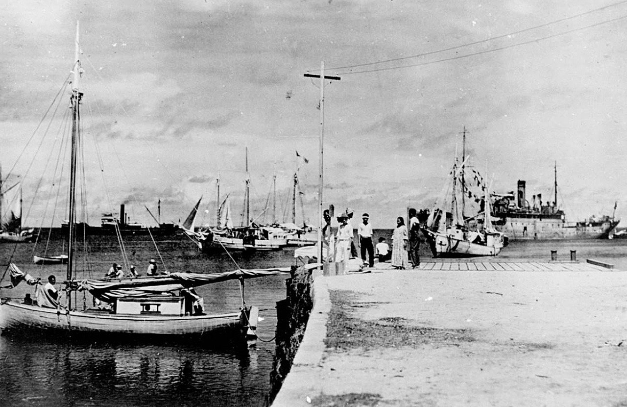
A newly discovered photograph suggests legendary aviator Amelia Earhart, who vanished 80 years ago on a round-the-world flight, survived a crash-landing in the Marshall Islands.

The photo, found in a long-forgotten file in the National Archives, shows a woman who resembles Earhart and a man who appears to be her navigator, Fred Noonan, on a dock. The discovery is featured in a new History channel special, "Amelia Earhart: The Lost Evidence," that airs Sunday.

Independent analysts told History the photo appears legitimate and undoctored. Shawn Henry, former executive assistant director for the FBI and an NBC News analyst, has studied the photo and feels confident it shows the famed pilot and her navigator.

"When you pull out, and when you see the analysis that's been done, I think it leaves no doubt to the viewers that that's Amelia Earhart and Fred Noonan," Henry told NBC News.

Earhart was last heard from on July 2, 1937, as she attempted to become the first woman pilot to circumnavigate the globe. She was declared dead two years later after the U.S. concluded she had crashed somewhere in the Pacific Ocean, and her remains were never found.

http://www.islandbreath.org/2017Year/07/170706harborbig.jpg
Image above: View of Jaluit Harbor in the Marshall Islands. The photo shows a woman who resembles Earhart and a man who appears to be her navigator, Fred Noonan, on a dock in the Marshall Islands. The Japanese ship, the Koshu, can be seen in the background towing what investigators believe could be Earhart’s Lockheed Electra plane. Click to enlarge. From (http://www.huffingtonpost.com/entry/amelia-earhart-survived-plane-crash-photo-japanese_us_595cfac6e4b0da2c73265d82).

But investigators believe they have found evidence Earhart and Noonan were blown off course but survived the ordeal. The investigative team behind the History special believes the photo may have been taken by someone who was spying for the U.S. on Japanese military activity in the Pacific.
It is not clear how Earhart and Noonan could have flown so far off course.

Les Kinney, a retired government investigator who has spent 15 years looking for Earhart clues, said the photo "clearly indicates that Earhart was captured by the Japanese."

Japanese authorities told NBC News they have no record of Earhart being in their custody.

The photo, marked "Jaluit Atoll" and believed to have been taken in 1937, shows a short-haired woman — potentially Earhart — on a dock with her back to the camera. (She's wearing pants, something for which Earhart was known.) She sits near a standing man who looks like Noonan — down to the hairline.

"The hairline is the most distinctive characteristic," said Ken Gibson, a facial recognition expert who studied the image. "It's a very sharp receding hairline. The nose is very prominent."
Gibson added: "It's my feeling that this is very convincing evidence that this is probably Noonan."

The photo shows a Japanese ship, Koshu, towing a barge with something that appears to be 38-feet-long — the same length as Earhart's plane.

For decades, locals have claimed they saw Earhart's plane crash before she and Noonan were taken away. Native schoolkids insisted they saw Earhart in captivity. The story was even documented in postage stamps issued in the 1980s.

"We believe that the Koshu took her to Saipan [in the Mariana Islands], and that she died there under the custody of the Japanese," said Gary Tarpinian, the executive producer of the History special.
"We don't know how she died," Tarpinian said. "We don't know when."

Josephine Blanco Akiyama, who lived on Saipan as a child, has long claimed she saw Earhart in Japanese custody.

"I didn't even know it was a woman, I thought it was a man," said Akiyama. "Everybody was talking about her — they were talking about in Japanese. That's why I know that she's a woman. They were talking about a woman flyer."

It is not clear if the U.S. government knew who was in the photo. If it was taken by a spy, the U.S. may not have wanted to compromise that person by revealing the image.


Video above: NBC TV news story on photo's discovery and its implications. From (https://youtu.be/dUMi4hch8qY).

.

See "The Strangled Sea"

SUBHEAD: The courageous Okinawan struggle against U.S. military destruction of their beautiful island.

By Katherine Muzik PHD on 9 May 2017 in Island Breath -
(http://islandbreath.blogspot.com/2017/05/see-stranged-sea.html)

http://www.islandbreath.org/2017Year/05/170509poster.pdf
Image above: Poster for "The Strangled Sea" event. Click for enlarged PDF file to post around the island.

WHAT:
See film "The Strangled Sea" (in Japanese with English Subtitles)
Presented by Professor Kosuzu Abe, an activist and Social Scientist, Ryukyu University
For the Okinawans it is a matter of "Peace, Beauty and Agony".

WHEN:
Saturday, 20 May 2017 at 7:00 - 9:30pm

WHERE:
Kealia Farm Market
2345 Kealia Road, Kealia, Kauai, HI 96746
Venue phone number: +1 808-635-4100

COST:
Free (but donations appreciated).

ENDORSED: 
by the Kauai Alliance for Peace ans Social Justice

MORE INFO:
For more information call +1 (808) 346-6167

Besides the film their will be a presentation of “Threatened to Death“ honoring the wonders of Okinawa’s Oura Sea and Yambaru Forest by Katherine Muzik, Ph.D., Marine Biologist

There will also ne Q & A to discuss America's increased militarization of Okinawa, Puerto Rico, Korea and Kauai...

.

"No!" to American Militarism

SUBHEAD: Living in Hawaii we are increasingly feeling the brunt of American worldwide imperialism.

By Juan Wilson on 11 April 2017 for Island Breath -
(http://islandbreath.blogspot.com/2017/04/no-to-american-militarism.html)

http://www.islandbreath.org/2017Year/04/170411mapbig.jpg
Image above:  Map of the area around Hanapepe Bay noting the National Guard facility, Salt Pond Store, the Poulo Point Runway, and Hanapepe River where military personell have been recently seen. map created by Juan Wilson with GoogleEarth. Click to enlarge.

Back in late 2015, in a comment on an article Ea O Ka Aina: Navy's "Illegal" War Games by Dahr Jamal,  I wrote:

"Keep in mind this navel war is coming to Hawaii in 2016 in the form of RIMPAC 2016. Just like last year the US Navy and its Pacific Rim allies (and others) will come to Hawaii, and especially to Oahu, the Big Island and Kauai. Just last week I witnessed what appeared to be platoon of US Marines checking out the boat landing just north of the 1911 One Lane Bridge on the Hanapepe River. Will there be a US Marine landing of special op zodiacs in my neighborhood this coming summer?"

Well, 

For the last few months we have been seeing the increase of American military activity here on Kauai, Hawaii. There have been more active duty troops present in the Hanapepe area than I have ever seen. I mean by that armed platoon squads in combat gear out and about in residential areas.

Hanapepe does provide a home for Army National Guard facility, but most of the time meetings and activities are on the grounds of National Guard facility.

I am sensitive to this issue because live in Hanapepe Valley. It's fairly rural and surrounding communities of Elelele and Hanapepe Heights are suburbs of single family dwellings. The Hanapepe River and its banks, as well as the area of Puolo Point and Salt Pond Beach Park are recreational areas for families, adults and children.

On two occasions on the last two months I've run across camo-uniformed teams of US soldiers carrying weapons at-the-ready along the shorelines of town.

The first time was a bit after a Marine MV-22 Osprey flew over the swimming area of Salt Pond Beach Park to make a loud and disturbing landing and take off at the Puolo Point runway. My wife and I were driving east on Lele Road, coming from the Salt Ponds going parallel to the Puolo Point runway. As we approached Hanapepe Bay where the road turns north a platoon of uniformed soldiers wearing full packs were trotting together with semi-automatic weapons drawn. I think they were marines. We were a bit startled. The area they were coming from is primarily used for recreation. Walkers, fishermen, bicyclists and those who just want to park and watch the sunset are who use the point.  

The second time was this last week when I was driving along the shore of Hanapepe Bay heading east by the tennis courts. A group of soldiers, maybe five, were coming out of a private driveway right on the shore where the Hanapepe River meets the Hanapepe Bay. These soldiers were also dressed in camo and had what appeared to be automatic weapons, in their hands (not slung over their shoulders). Their faces were painted to be camouflaged as well. They appeared to be a special forces unit. It was obvious they had come from some practice on the Hanapepe River. Again this is an area used mostly for recreation. Paddlers, kids exploring, fishermen use the area. I do not like the idea of this area of Hanapepe being used by the military for "practice".

 Things are definitely "gearing up" for the military on Kauai. The State of Hawaii is about to start construction a complete rebuild of the main bridge over the Hanapepe River. Many are of the opinion that this is being attended to because of the necessity of heavy trucks going to the Pacific Missile Range Facility (PMRF) on the west end of the island as it expands to include Airforce, Marine and Naval military presence.

There is plenty of action in and around the National Guard facility. Salt Pond Country Store is across the street. When there are military personnel at the facility, the store gets their action. Yesterday I was at the store and the guy ahead of me at the cash register caught my curiosity. He was trim with khaki shorts and a maroon t-shirt the read on the back "University of Wake Island - Noledge". As he turned I could see he was a serious looking, trim-bearded millennial.


Image above: A Chevy Tahoe model like the one I saw parked in front of Salt Pond Store opposite the National Guard facility in Hanapepe. From (http://www.tahoeyukonforum.com/threads/the-official-blacked-out-tahoe-yukon-picture-thread.1052/). For more images of this kind of "civilian" presence on Kauai see Ea O Ka Aina: Hands Across the Sand Westside.

This didn't look like a guy on vacation. I followed him out of the store. As I passed him he was getting into the shotgun seat of an new seven-seat  black Chevy Tahoe Yukon SUV with dark tinted windows.  The sun back-lighted the vehicle so I could see the seats were fully occupied by more guys.

These were not tourists. My take was they were either military intelligence or ballistic missile technicians - at least one of whom had recently come from a tour on Wake Island. By the way, Wake Island is the home of the Ronald Reagan Ballistic Missile Defense Test Site.  The Island is administered by the United States Air Force, under an agreement with the Department of the Interior. Nice fit with the PMRF. See more at (http://www.thelivingmoon.com/45jack_files/03files/Wake_Island_01.html)


Video above: "Honest Government Advert - Visit Hawaii". The US Government just released this tourism ad for Hawaii and it's surprisingly honest and informative. From (https://www.facebook.com/juicerapnews/videos/10155918517468452/) and (https://youtu.be/MfAiB2ZoRhM).

See also:
Ea O Ka Aina: Military buildup at PMRF 2/22/17
Ea O Ka Aina: Air Force plans to bomb whales 2/6/17
Ea O Ka Aina: MV-22 Osprey landing at Salt Pond 2/5/17
Ea O Ka Aina: Kauai and Niihau endangered 9/24/16
Ea O Ka Aina: DLNR responsibility on RIMPAC 7/5/16
Ea O Ka Aina: Oceans4Peace Pacific Pivot Panel 6/18/16
Ea O Ka Aina: Ocean 4 Peace Events 6/11/16
Ea O Ka Aina: Prepare for RIMPAC 2016 War in Hawaii 5/22/16
Ea O Ka Aina: Navy to "take" millions of mammals 5/17/16
Ea O Ka Aina: Fuck the PMRF's Aegis plan! 1/23/16
Ea O Ka Aina: Navy's illegal War Games 11/16/15
Ea O Ka Aina: US court RIMPAC Impact decision 4/3/15
Ea O Ka Aina: Kauai's PMRF is bang out of sight 6/28/14
Ea O Ka Aina: The Pacific Pivot 6/28/14
Ea O Ka Aina: RIMPAC IMPACT 6/8/14
Ea O Ka Aina: RIMPAC Then and Now 5/16/14
Ea O Ka Aina: Earthday TPP Fukushima RIMPAC 4/22/14
Ea O Ka Aina: The Asian Pivot - An ugly dance 12/5/13
Ea O Ka Aina: Help save Mariana Islands 11/13/13
Ea O Ka Aina: End RimPac destruction of Pacific 11/1/13 
Ea O Ka Aina: Moana Nui Confereence 11/1/13
Ea O Ka Aina: Navy to conquer Marianas again  9/3/13
Ea O Ka Aina: Pagan Island beauty threatened 10/26/13
Ea O Ka Aina: Sleepwalking through destruction 7/16/12
Ea O Ka Aina: PMRF Aegis missile test 5/11/12
Ea O Ka Aina: Okinawa breathes easier 4/27/12
Ea O Ka Aina: Navy Next-War-Itis 4/13/12
Ea O Ka Aina: America bullies Koreans 4/13/12
Ea O Ka Aina: Despoiling Jeju island coast begins 3/7/12
Ea O Ka Aina: Jeju Islanders protests Navy Base 2/29/12
Ea O Ka Aina: Hawaii - Start of American Empire 2/26/12
Ea O Ka Aina: Korean Island of Peace 2/26/12
Ea O Ka Aina: Land based Aegis on Kauai 9/2/11  
Ea O Ka Aina: Military schmoozes Guam & Hawaii 3/17/11
Ea O Ka Aina: In Search of Real Security - One 8/31/10
Ea O Ka Aina: Peace for the Blue Continent 8/10/10
Ea O Ka Aina: Shift in Pacific Power Balance 8/5/10
Ea O Ka Aina: RimPac to expand activities 6/29/10
Ea O Ka Aina: Hands Across the Sands Westside 6/27/10
Ea O Ka Aina: RIMPAC War Games here in July 6/20/10
Ea O Ka Aina: Pacific Resistance to U.S. Military 5/24/10
Ea O Ka Aina: Guam Land Grab 11/30/09
Ea O Ka Aina: Guam as a modern Bikini Atoll 12/25/09
Ea O Ka Aina: GUAM - Another Strategic Island 11/8/09
Ea O Ka Aina: Diego Garcia - Another stolen island 11/6/09
Ea O Ka Aina: Polihale Clean Up 4/6/09
Ea O Ka Aina: DARPA & Super-Cavitation on Kauai 3/24/09 
Ea O Ka Aina: Polihale access to be restored 3/11/09
Ea O Ka Aina: Polihale access denied! 2/25/09
Ea O Ka Aina: Residents want beach access 1/5/09
Island Breath: RIMPAC 2008 - Navy fired up in Hawaii 7/2/08
Island Breath: RIMPAC 2008 uses destructive sonar 4/22/08
Island Breath: Navy Plans for the Pacific 9/3/07
Island Breath: Judge restricts sonar off California 08/07/07
Island Breath: RIMPAC 2006 sonar compromise 7/9/06
Island Breath: RIMPAC 2006 - Impact on Ocean 5/23/06
Island Breath: RIMPAC 2004 - Whale strandings on Kauai 9/2/04
Island Breath: PMRF Land Grab 3/15/04.