SUBHEAD: The unseen wars on the Pacific Ocean lead by the United States Navy is cranking up this summer.
By Oceans4Peace Staff on 2 July 2014 in Island Breath -
(http://islandbreath.blogspot.com/2014/07/war-on-ocean.html)

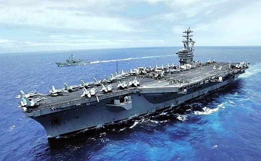
Image above: Detail of image from poster for panel discussion and talk-story on July 12, 2014. Click to enlarge and see full poster (for printing and handing out).
WHAT:
Free panel discussion and talk-story on impacts on Pacific Ocean by military activity focusing on Jeju Island, Okinawa and Hawaii (RIMPAC 2014).
PANEL:
"What happens when coral reefs are militarized: Jeju Island, South Korea"
Jim Maragos PhD - Expert on Pacific Ocean atoll ecology
"The last pristine coral reef ecosystem of Okinawa Island"
Kenta Watanabe MS - Tropical Botanist Okinawa national College of Technology
"Effects of RIMPAC on Marine Life"
Katherine Muzik PhD - Director of Kuku Wai Environmental Education Instititute
Moderator will be Juan Wilson, publisher of IslandBreath.org
WHEN:
Saturday July 12th 2014 at 5:00-7:00pm
WHERE:
Kapaa Public Library
4-1464 Kuhio Highway
Kapaa, HI, 96746
INFO:
Call (808) 822-7646
SPONSORS:
Kauai Alliance for Peace & Social Justice
Kohola Leo
Hawaii Sierra Club Kauai Chapter
Surfrider Foundation
People for the Protection of Kauai
Video above: Public service announcement about RIMPAC 2014 and its impact on Hawaii's ocean creatures by Surfriders. From (http://youtu.be/DIF9tdtmU0E).
INTRODUCTION:
Below is a draft of the planned introduction to the panal discussion to be presented by the moderator, Juan Wilson:
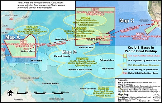
Below is map combing various US territorial claims in the Pacific Ocean including enormous military test range and war simulation areas. For more details see Island Ea o Ka Aina: The Pacific Pivot 6/26/14.

Image above: BATTLEGROUND OVERVIEW - Thumbnail of map joining Maps A, B and C showing Pacific Ocean U.S.A. state, territory and protectorates as well as military range and testing facilities US marine national monuments existing and proposed. Together these areas provide a complex and overlapping set of protocols, regulation and control that clusterfuck much of the Pacific Command area. Map by Juan Wilson (www.isladnbreath.org). Click for larger more complete view.
.
By Oceans4Peace Staff on 2 July 2014 in Island Breath -
(http://islandbreath.blogspot.com/2014/07/war-on-ocean.html)

Image above: Detail of image from poster for panel discussion and talk-story on July 12, 2014. Click to enlarge and see full poster (for printing and handing out).
WHAT:
Free panel discussion and talk-story on impacts on Pacific Ocean by military activity focusing on Jeju Island, Okinawa and Hawaii (RIMPAC 2014).
PANEL:
"What happens when coral reefs are militarized: Jeju Island, South Korea"
Jim Maragos PhD - Expert on Pacific Ocean atoll ecology
"The last pristine coral reef ecosystem of Okinawa Island"
Kenta Watanabe MS - Tropical Botanist Okinawa national College of Technology
"Effects of RIMPAC on Marine Life"
Katherine Muzik PhD - Director of Kuku Wai Environmental Education Instititute
Moderator will be Juan Wilson, publisher of IslandBreath.org
WHEN:
Saturday July 12th 2014 at 5:00-7:00pm
WHERE:
Kapaa Public Library
4-1464 Kuhio Highway
Kapaa, HI, 96746
INFO:
Call (808) 822-7646
SPONSORS:
Kauai Alliance for Peace & Social Justice
Kohola Leo
Hawaii Sierra Club Kauai Chapter
Surfrider Foundation
People for the Protection of Kauai
Video above: Public service announcement about RIMPAC 2014 and its impact on Hawaii's ocean creatures by Surfriders. From (http://youtu.be/DIF9tdtmU0E).
INTRODUCTION:
Below is a draft of the planned introduction to the panal discussion to be presented by the moderator, Juan Wilson:
Aloha to all of you, Tonight Oceans4Peace presents a panel discussion and talk story. Our subject tonight is the War on the Ocean and RIMPAC 2014. We'll focus on Jeju Island, Okinawa and Hawaii. BATTLEGROUND OVERVIEW (see below). The Pacific Ocean has been used as a sushi bar, a strip mine, a junk yard, a toilet bowl, a bombing range, and a nuclear wasteland. But underlying the gloss there are many ongoing and overlapping military activities in the Pacific that we do not see advertised and that are deeply troubling. A pattern emerges that clarifies the purpose of the Trans-Pacific Parternship (or TPP)…. It is is in effect a demand for the surrender of the Pacific Ocean to America's Asian Pivot. This downward spiral must be stopped - And being informed helps! |
Below is map combing various US territorial claims in the Pacific Ocean including enormous military test range and war simulation areas. For more details see Island Ea o Ka Aina: The Pacific Pivot 6/26/14.

Image above: BATTLEGROUND OVERVIEW - Thumbnail of map joining Maps A, B and C showing Pacific Ocean U.S.A. state, territory and protectorates as well as military range and testing facilities US marine national monuments existing and proposed. Together these areas provide a complex and overlapping set of protocols, regulation and control that clusterfuck much of the Pacific Command area. Map by Juan Wilson (www.isladnbreath.org). Click for larger more complete view.
.
No comments :
Post a Comment