Showing posts with label Shoreline. Show all posts

Kauai Puna Moku Update

SUBHEAD: Modification to Niumalu and Huleia ahupuaa boundary to provide better access to shoreline.

By Juan Wilson on 19 May 2018 for Island Breath -
(http://islandbreath.blogspot.com/2018/05/kauai-puna-moku-update.html)

http://www.islandbreath.org/hawaiinei/M7Kauai/M7KauaiRasterFile.png
Image above: Detail of change to Kauai moku of Puna Huleia ahupuaa boundary with Niumalu. Click for full map. From (http://www.islandbreath.org/hawaiinei/M7Kauai/M7KauaiRasterFile.png).

After a consultation with Jonathan Jay we have made a modification to the boundary between  Niumalu and Huleia ahupuaa in the moku of Puna on the island of Kauai.  We think a clearer and improved boundary line has been delineated.

In previous versions of the Puna plan the Huleia ahupuaa failed to reach the true coastline of Kauai, and thus was landlocked with only Huleia Stream passing out to the ocean between Niumalu and Kipu.

We have also recently added an additional layer of information to Kauai that includes many of the locations and names of significant mountain peaks. This is important to understanding moku and ahupuaa boundaries, especially from a ground's eye perspective.

We have not yet scheduled work on the mountain peaks of other islands. It would likely require weeks of work.

Hawaiinei Land Areas
Available updated downloads for Kauai:
GoogleEarth file .KMZ (15 MB) uploaded 5/19/18
24"x36"Plotfile .PDF (44 MB) uploaded 5/19/18
Hi RezRaster File .PNG (15 MB) uploaded 5/19/18
ArcView GIS files SHP .ZIP (319 KB) uploaded 5/19/18
AutoCAD files DXF .ZIP (2.7 MB)  uploaded  5/19/18  


 .

Save Hawaii's beaches or property?

SUBHEAD: Climate change and ocean rise is forcing difficult choices on Hawaii now.

By Nathan Eagle on 28 July 2017 for Civic Beat -
(http://www.civilbeat.org/2017/07/save-beaches-or-property-climate-change-will-force-tough-choices/)


Image above: A Waikiki lifeguard station surrounded by ocean water is barely operational today. From original article promo.

A coastal hazard expert briefs Hawaii officials and others about the need to adapt to rising sea levels and warmer temperatures.

With the impacts of climate change bearing down on Hawaii, government officials and community members need to make some important decisions about the islands’ iconic coastlines, said Dolan Eversole, a coastal hazards expert with the University of Hawaii’s Sea Grant program.

“That’s the policy question that we’re faced with now — what’s more important, protecting the property or protecting the beach?” he said. “It’s not a simple answer.”

Eversole was addressing a roomful of state and county officials, nonprofit leaders and others Thursday at the annual State of Hawaii Drowning Prevention and Ocean Safety Conference at the Hawaii Convention Center in Honolulu.

Even under conservative projections, he said Hawaii will have to adapt to a suite of issues that are exacerbated by increasing temperatures and rising sea levels, including coastal erosion, hurricanes, tsunamis, high surf, high winds and flooding.

“Climate change is not necessarily an independent problem,” Eversole said. “It’s going to overlie the problems that we have and in many cases make them worse.”

The “king tides” that caused flooding in Waikiki and other parts of the state this summer were in many ways a glimpse into the future, he said.

It’s not all doom and gloom though, at least compared to other coastal states like Florida and Louisana that are also being forced to adapt to climate change.

Hawaii has the advantage of topography, Eversole said. Elevations increase quickly in the mountainous islands, so adapting for some can mean moving to the other side of Kamehameha Highway, which wraps around Oahu’s northern coast.


Image above: Coastal highway on north shore of Oahu threatened by high ocean waves. From original article.

“It’s going to be inconvenient but we won’t have to go too far,” he said, underscoring how that’s not even an option in some other places.

Eversole is also heartened by Hawaii having a climate adaptation plan underway. The first part of that plan, due in December, will show how sea-level rise will likely affect hotels, homes and other properties in the coming decades.

Honolulu Emergency Services Director Jim Howe, who was the city’s longtime ocean safety chief, said the city has much of the necessary information and has started to respond.

He said the newly created Office of Climate Change, Resilience and Sustainability has held its first major gathering of stakeholders to gain input. A full report from that meeting with roughly 350 individuals from businesses, nonprofits, government and environmental groups is coming, he said, but the preliminary results illustrate the need to focus on the coastal areas and infrastructure.

“We’re going to have to make some priority decisions,” Howe said. “Where are we going to best spend our money? What is going to be the best approach for us as a community? That’s a dialogue that we need to have.”

He said Hawaii has to brace for weather impacts, from increased flooding to more frequent hurricanes.

“All of us in the community need to be prepared,” Howe said. “The more we can be proactive, the better off we’re going to be in the end.”

There’s a lot at stake. Hawaii’s economy largely depends on millions of tourists coming to visit its famed beaches.

Hospitality Advisors, a consulting firm, estimated Waikiki Beach alone contributes more than $2 billion in visitor spending annually.

Waikiki Beach is already in need of millions of dollars of overdue work and there’s still no master plan for the beach, Eversole said.


Image above: The beach at the Royal Hawaiian Hotel is under ocean waves that break against the hotel's porch railing. From original article promo.

And the adjacent Kuhio Beach is a “public safety emergency,” he said, noting how sections of the groin are collapsing in front of a mound where hula dancers perform.

“It’s a mess right now,” he said. “It’s the worst I’ve ever seen it.”

Studies are underway, including the state’s $800,000 Waikiki Beach Technical Feasibility Study, and public-private partnerships have formed to address the most serious problems.

The Waikiki Beach Special Improvement District Association is splitting a $1.5 million project with the state to fix the Royal Hawaiian groin, which Eversole said “literally holds together Waikiki Beach.”

Commercial properties pay a special tax that funds the association’s projects, which are all focused on beach management.

Construction may not begin for two years, though, due to permit requirements, Eversole said.

“Hawaii is probably one of the most vulnerable areas to coastal hazards in the world,” he said.

This is not the first time Eversole has waved flags trying to alert the public and policymakers to the problems Hawaii faces due to climate change.

He was lead author of a 2014 UH Sea Grant report, funded by the Hawaii Tourism Authority, that details the current and future effects of climate change in the islands.

Eversole said what concerns scientists the most are the extremes, not the averages, in terms of swings in temperatures and the rates of change.

The rate of warming air temperature in Hawaii has quadrupled in the last 40 years to more than 0.3 degrees Fahrenheit per decade. This causes stress for plants and animals, heat-related illnesses in humans and expanded ranges for pathogens and invasive species, he said.

“It could get exponential at some point in the future unless we do something about it,” he said.

When it comes to sea-level rise, the global average is 4 millimeters a year, but it’s not uniform. Low-lying atolls in the western Pacific are seeing 10-millimeter increases annually while Hawaii is averaging 1.5 millimeters a year.

Eversole said that Hawaii should not bank on its below-average increase because projections show it will greatly accelerate.

“Inarguably in the scientific community, climate change is real. There is no question,” he said. “The only question that surrounds climate change is what do we do about it. We’re in a catch-up mode.”
.

Sea level rise estimates too low

SUBHEAD: New report suggests sea level rise likely worse than previously thought, especially in Hawaii. 

By Teresa Dawson on 13 March 2017 in Civil Beat -
(http://www.civilbeat.org/2017/03/report-suggests-sea-level-rise-may-be-worse-than-previously-thought/)


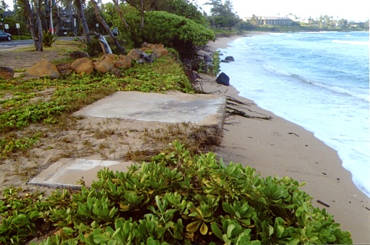
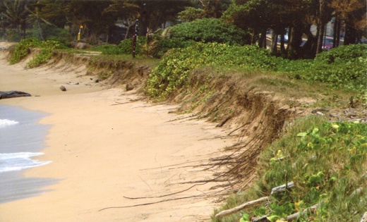
Image above: High surf erodes the highway’s edge on the North Shore of Oahu. Photo by Teresa Dawson. From original article.

A new technical report by the National Oceanic and Atmospheric Administration suggests that climate change-induced sea level rise over the course of this century, especially in Hawaii, may be far worse than predicted in the Intergovernmental Panel on Climate Change scenario that has been serving as a guide for a number of local efforts to address climate change impacts.

As a result, the state’s Sea Level Rise Vulnerability Assessment and Adaptation Report, due to the Legislature by year’s end, may be more useful as a guide for shorter-range planning for non-critical structures that can be moved or replaced relatively easily.

The local scientists and planners developing the SLR report, required by Act 83 of the 2014 Legislature, have based their inundation scenarios for coastal areas throughout the state on the IPCC’s “worst of the worst-case scenarios,” according to Dr. Chip Fletcher, University of Hawaii associate dean for the School of Ocean and Earth Science and Technology.

In that scenario, sea level rises about half a foot by 2030, a foot by 2050, 2 feet by 2075, and 3.2 feet (or roughly 1 meter) by 2100.

The NOAA report, however, suggests that the current melting rate of alpine glaciers and glaciers in Greenland and Antarctica, as well as the rate of thermal ocean expansion, may cause sea levels globally to rise an average of 0.3 m (about a foot) in the low-consequence/high-probability scenario but up to an average of 2.5 meters (about 9 feet) in its extreme-consequence/low-probability scenario by 2100.

Static-equilibrium effects will cause some regions around the globe to experience even higher sea levels, the report states, and the tropics is one of them.

“Hawaii is sitting in the worst region of all,” Fletcher said.

He and others working on the state’s SLR report had believed when they started that a 1-meter rise in sea level was an extreme scenario, which he said is appropriate for long-range planning of long-lived, expensive, critical structures or infrastructure such as a nuclear power plant or a hospital in the coastal zone.

But under NOAA’s new projections, Hawaii is expected to see a 1.3-meter rise in sea level by 2100 under its intermediate case, he said. Under its most extreme, but least probable case, the state would see a 3.3-meter (nearly 11-foot) rise.

In light of NOAA’s new scenarios, Tetra Tech’s draft predictions for the SLR report are now far less speculative and much more reliable than they were before. Under a 3.2-foot rise in sea level, Tetra Tech as of press time had estimated that inundation impacts on Oahu alone could cost $11.8 billion, impact 9,400 acres and 3,800 structures, and displace 13,300 residents.

The firm’s planner Kitty Courtney stressed at an SLR workshop that the economic impact reflects the potential cost if nothing is done to mitigate impacts.

‘Planning Envelope’

The NOAA report, titled “Global and Regional SLR Scenarios for the United States,” is the result of work begun in August 2015 for the Sea Level Rise and Coastal Flood Hazard Scenarios and Tools Task Force, a joint task force of the National Ocean Council and the U.S. Global Change Research Program.

Using the best available science, the task force is charged with developing future relative sea levels, associated coastal flood hazard scenarios, and tools to “serve as a starting point for on-the-ground coastal preparedness planning and risk management processes, including compliance with the new Federal Flood Risk Management Standard,” the report states.

The report describes six global mean sea level (GMSL) rise scenarios: Low, Intermediate-Low, Intermediate, Intermediate-High, High and Extreme, ranging from most likely to least likely to occur.
In setting the upper bounds of its SLR projections for 2100, the scientists who produced the report assessed the latest literature on “scientifically supported upper-end GMSL projections, including recent observational and modeling literature related to the potential for rapid ice melt in Greenland and Antarctica.”

“The projections and results presented in several peer-reviewed publications provide evidence to support a physically plausible GMSL rise in the range of 2.0 meters to 2.7 (meters), and recent results regarding Antarctic ice-sheet instability indicate that such outcomes may be more likely than previously thought,” the report states.

Despite the low probability that sea levels will actually rise to 2.7 meters by the end of the century, the report’s authors warn against planners discounting this.

“For decisions involving long planning horizons and with a limited adaptive management capacity, the high degree of uncertainty in late-21st century GMSL rise looms large. Failure to adequately account for low-probability, high-consequence outcomes significantly increases future risks and exposure,” the report states. “For many decisions, it is essential to assess worst-case scenarios, not only those assessed as the scientifically ‘likely’ to happen.”

The report recommends that to assess a system’s overall risk and determine long-term adaptation strategies, planners should define a “scientifically plausible upper-bound (which might be thought of as a worst-case or extreme scenario) as the amount of sea level rise that, while low probability, cannot be ruled out over the time horizon being considered.”

For shorter-term planning, such as for adaptation strategies within the next 20 years, the report suggests that planners define a “central estimate or mid-range scenario (given assumptions about greenhouse gas emissions and other major drivers).”

“This scenario and the upper-bound scenario can together be thought of as providing a general planning envelope,” the report states.

Local Impacts

Although NOAA’s intermediate SLR scenario clearly anticipates a rise of more than 1 meter, the state’s report isn’t likely to include a robust analysis of a rise higher than that.

Fletcher, however, made it clear that NOAA’s higher-consequence scenarios would devastate certain coastal areas of the state. Under NOAA’s high scenario, he said, inundation would rise to the point where it would permanently drown Ewa Beach on Oahu’s south shore, which is home to tens of thousands of residents.

Tetra Tech’s Courtney, who also spoke at the workshop, presented several preliminary maps and charts indicating that even an increase in sea level of 1 to 3 feet could cause significant and widespread damage, especially when combined with increased erosion, annual high wave flooding, and a 1 percent annual chance of a coastal flood (also known as a 100-year flood).

A couple of the maps she displayed showed the numerous spots along Oahu’s coastal highway, including areas on the windward side and along Honolulu’s impending rail transit alignment, that would be vulnerable to inundation due to sea level rise. Another map highlighted the more than two dozen schools, hospitals and clinics, police and fire stations, and wastewater treatment plants within the Honolulu area that would be flooded by a 100-year flood under a 3.2-foot rise in sea level. And yet another showed that that flood area would extend a mile or more inland from the current FEMA VE zone boundary, where landowners are required to have flood insurance.

With regard to the potential impacts on the Honolulu rail transit system, Courtney noted, “Transit-oriented development is probably what we do really need to do … but on the other hand, we gotta make sure we’re taking into consideration some of these long-term impacts of sea level rise.”

Referring to some of her maps showing projected inundation on Oahu’s west and north shores, Courtney said that beaches are going to be lost and many of them are state parks or recreation areas. She also noted that increased erosion will also likely unearth or damage historic cultural sites, such as those at Kawela Bay.

“What do we need to do to protect a beach? … How do we continue to have beaches in the state?” she asked.

So far, no inundation charts for any of the outer islands have been presented. When the report is complete, Courtney indicated that the most thorough inundation and economic impact assessments in the report will be for the islands of Kauai, Maui and Oahu, for which there is a rich amount of historical data. “For Molokai and Lanai, we have some limitations in historical records for coastal erosion and annual high wave flooding,” she said.

An assessment for the Big Island will also be included.

Note:
Reprinted by Civil Beat with permission from the current issue of Environment Hawaii, a non-profit news publication founded in 1990. All issues published in the last five years are available free to Environment Hawaii subscribers at www.environment-hawaii.org. Non-subscribers must pay $10 for a two-day pass. All issues older than that are free to the public.


• Teresa Dawson is a staff writer for Environment Hawaii and has freelanced for Environmental Health News and the Honolulu Weekly. She was born and raised in Hawaii.

.

Please step out of the vehicle!

SUBHEAD: It's for your own health, safety and sanity. You can't say you haven't been warned.

By Juan Wilson on 3 March 2015 for Island Breath -
(http://islandbreath.blogspot.com/2015/03/please-step-out-of-vehicle.html)


Image above: Kauai Police Department’s Sgt. Roderick Green stands with one of the new Ford Explorer Police Interceptor Utility vehicles. From (http://thegardenisland.com/kpd-car-jpg/image_a19f6118-c8f2-11e2-86c8-0019bb2963f4.html).

Last week I attended a meeting with some of the members of a Kauai group of a national environmental organization. The group does good work for the community as well as provide services for the island and its visitors.

Much of the in-house work of the group has been adapted to work done at home and through telecommunications. This saves greatly on fuel burned in order get from Hanalei and Hanapepe just to sit and the same room and talk.

However, every so often we do get together for meetings when needed. The meeting was set for 11:00am at a unit of the Waipouli Beach Resort opposite the Kapaa Safeway. I began my trip from Hanapepe Valley with over an hour set for traveling time. Thus began my tribulation. 

Highway Blues
There is only one way around the island - the Kaumualii and Kuhio Highways that link up in Lihue.   They were crowded all the way from the Westside to the Eastside of the island. Some of it was normal Kauai traffic but I also had to pass a nasty accident between Tree Tunnel Road and Halfway Bridge.

If you are familiar with  in that area you might have noticed there is a "Bike Lane" marked with signs going west from Puhi. It mysteriously disappears before you get to Knudsen Gap with a cryptic sign that simply reads "Bike Lane Ends". What bike lane merely ends in the middle of nowhere?

I think this "Bike Lane Ends" is due to the fact that the bridges over the stream crossings along much of the Southside after Halfway Bridge were built in the 1930's when the vehicular traffic on Kauai was so light that oncoming traffic was a rarity.

Back then one-lane bridges were acceptable. From 1911 until the late 1938 the main highway over the Hanapepe River was a one-lane bridge.

Now those one-lane bridges over the Route 50 on the Southside are deathtraps to pedestrians and bikers, if two trucks are passing one another while you are on one of those bridges. Between the stone wall of the bridge and the side of a speeding truck there is hardly the room for a wobbly bike handle bar.

Several years ago my wife Linda and I were driving west on this section of road and came across a couple with three young children on bikes as they were approaching the "Bike Lane Ends" sign. They kept going and Linda and I worried about their safety.


Image above: Approaching the "Tree Tunnel" Road from the west. Note stone bridge over stream ahead with no margin for bikes or pedestrians. (http://islandbreath.org/2005Year/a05-01-access/0501-13KauaiBikeways.html)

Accident Along the Highway
As I passed the Tree Tunnel Road going east there were cones in the road diverting traffic around a tree trimming operation that was working on the side of the road going westbound. Traffic slowed to a crawl. But the traffic was not alleviated once past the tree trimming trucks. There were more cones behind the trucks diverting westbound traffic toward the east-bound traffic so as to avoid the tree trimming. Ahead of me were flashing lights. Two cop cars and a fire truck were there. Also an ambulance with a empty stretcher.

East of the ambulance a single new model car was parked on the verge with a caved in grill. Behind the ambulance I could just see the outstretched arms of the victim. It seemed the paramedics were still working to stabilize the victim before transfer to the stretcher.

What seems to have happened was a cyclist followed the line of cones and was clipped from behind by the car with the bent grill. A did not see a twisted bike, but I figure someone walking would have stayed outside of the cones and avoided the traffic until they got to the tree trimming.  

More Different Bike Path
If the state and county had any interest in cycling they would change their priorities entirely. At a fraction of the cost per mile of their current "Bike Path"construction plans, they could make much of the island accessible for bikes. They would simply add a relatively cheap bike crossing bridge on the sides of the 1930 deathtrap they call bridges now along the southern leg of Route 50. I have not counted them but my sense it it may be as few as a dozen such crossings.

On the Southside this would open Koloa, Poipu, and Kukuiula to cyclists as well as be the first phase of a gateway to the whole Westside. Once past Kalaheo riders could take the lovely Rt 540 bypass down to Old Hanapepe Town. Beyond this, biking is fairly easy.


Image above: Does this Costco look familiar? The corner entrance, the food court on the right hand, the mountain in the background?  No it's not Puhi, but Costco Rancho Cucamonga. From (http://www.fuscoe.com/portfolio-items/costco-wholesale/).

Continuing Down the Road
The traffic was solid past halfway Bridge and into Puhi.  There a large new shopping plaza is arising in what was recently an open field opposite the Chiefess Kamakahelei, Middle School and the YMCA of Kauai Fitness Center. Both of those were fields in recent years too. Nearby is the Home Depot and Costco (which replaced a public park). The effect of all this is architectural chaos and suburban sprawl.

What was once open space on either side of the road is morphing into the southern California hell of Rancho Cucamonga.

The road goes on in a river of rental cars and commuters through the new (five years in the making) highway widening passing the Kukui Grove Mall, on past the Walmart and beyond.

I know, I know... this is what progress means. More time in your car's air conditioning, listening to an $800 dollar sound system while you checking your iPhone's text messages. At least you're getting some hard earned "me time".

But I digress.

Counter Intuitive Counter Flow
Once past the Walmart and Lihue we're into the chute of traffic cones that define the Counter Flow Lane between Hanamaulu and Kapaa. Every weekday northbound Route 50 is reduced to a single narrow lane by the placement by hand of thousands of OSHA orange traffic cones that allow two lane traffic south for the rush hour for half the day. I forgot the cost for this daily service that requires two trucks and a crew of eight.

Along the way we come to the next hurdle -  the traffic pile up once over the Wailua River of people trying to access Kaumoo Road and one of the largest areas of residential development on the island. This bottleneck is right where some idiots want to rebuild the Coco Palms Hotel. It was a bad idea when it was built over a Hawaiian cultural site and graveyard in 1953 and it's a worse idea now.

Climate change driven global warming will make this spot untenable in not much more than a generation. We have already seen the ocean cut away the beach right to the edge of the highway in 2012. (see http://islandbreath.blogspot.com/2012/08/wailua-beach-under-water.html and http://islandbreath.blogspot.com/2012/06/wailua-beach-erosion.html and http://islandbreath.blogspot.com/2012/12/wailua-beach-elephant-path.html). Some kind of passage across the  Coco Palms site may be the only way to to keep the north and south sides of the island connected.


Image above: Wailua Beach in 2012 with erosion taking out the life guard stand and endangering the highway. From (http://islandbreath.blogspot.com/2012/06/wailua-beach-erosion.html).

The Last Leg
Soon we are on to what was once called the Royal Coconut Coast. A 100 acres of coconut tree orchards were spread out on both sides of the Kuhio Highway. Over decades it has been picked apart by development. The Coconut Marketplace was one of the earliest big modernizations. It is now an almost abandoned shopping area with a few tourist traps. Most recently a gigantic Longs Drugs plaza was built blacktopping acres of coconut trees. More is planned. A few scraggly patches of palms still stand. Even that will be gone soon.

Then we crawl through traffic to Waipouli. Sprawl is dense here. Large supermarket anchored plazas (Foodland and Safeway) sit side by side. In the Waipouli Shopping Plaza where the Safeway is sits the now abandoned old Long's Drug store and a variety of low traffic store fronts.

Deep in this plaza was once a beautiful inner court that featured a waterfall behind a lava lock stage facing a lawn with a stream leading past a koi pond next to an artist's gallery.  Papaya's Health Food Store faces that courtyard and had tables and umbrellas for people to eat and rest in a cool quiet space away from the highway. It was truly a place of refuge on the suburbanized Eastside of Kauai.

Now waterfall, the stream the grass and the pond and gallery are gone. It was all  blacktopped over for additional parking that were requested by struggling retailers.

Across the street from the Waipouli Shopping Plaza was once about ten acres of undeveloped beachfront property with low dunes rimmed with ironwood trees. A field of grasses and bushes came all the way to the highway.

This was my destination. But it was not a field any more. It is now the recently opened Waipouli Beach Resort. It's also provides residences and vacation rentals.


Image above: Nighttime under the stars at theWaipouli Beach Resort. Tropical Elegance of Surf, Sun & Sushi equals Livin'the Dream!" From (http://www.vrbo.com/122141).

The meeting I was going to was to take place - in a top floor suite of the Waipouli Beach Resort. This one was one of the projects our group had fought so hard to stop in 2005 and 2006. (see http://islandbreath.org/2005Year/a05-02-growth/0502-08badplanning.html and http://islandbreath.org/2006Year/02-development/0602-07CocoPalms2.html)

I had never been on this site after construction. After the meeting I went on a walking tour around the grounds. The buildings are dense and as tall as legally allowed. They cluster around one of these amusement park styled pools that go on forever with slides and coves and even sport an artificial beach. I finally crossed the Eastside bike path along the ocean shore.

The developers of the Waipouli Beach Resort tried to force it mauka to go along the highway instead of along the shore. They lost that battle but their landscaping kind of hints that you are trespassing if you are in front of their beach.

But strangely that beach was empty. The swimming there is not good. It requires crossing a long shallow jagged reef.

Even so, you'd think that if you were at a "beach resort" you might try at least try sunning on the shore for a while. But no. Everybody was at the pool. It was safer and you can get a drink and a hamburger poolside. Who even needs a beach at a beach resort?

Some background
I guess I'm spoiled by having driven on Kauai for over a year in 1971-72. Back then there were no traffic lights at intersections of public roads. There were yellow warning lights on public roads that were occasionally turned on at harvest time when cane haul trucks crossed public roads loaded with sugarcane going to the mill.

Today the mills are dormant and much of the island is denied via the cane haul roads by padlocked gates. But back in the day the public had access to the streams, waterfalls, and forests of the plantations if it wasn't harvest time. Back then you could enter plantation property to park and then hike into all kinds of wonderful places. Not any more.

One after another those special mauka (inland) places have been denied -  Ooiki Falls in Hanapepe Valley; Waipahee Slippery Slide, Kealia; Kipu Falls, near Puhi...

...That is unless you have paid a hefty fee for a ride in an off-road-vehicle across tough terrain, or on a zip line through the trees, or in an inner-tube down a ditch.

Those old places for recreation will be lost to people on Kauai until the credit card wielding tourists don't come by the thousands anymore and the GMO companies fade back to the mainland.


.

Wailua Beach Erosion

SUBHEAD: Wailua Beach is backed against a new highway and eroding quickly. Should we jam in a bike path?  

By James Alalem & Ray Catania on 13 June 2012 in TGI -
(http://thegardenisland.com/news/opinion/mailbag/letters-for-wednesday-june/article_055bd342-b519-11e1-bf44-001a4bcf887a.html)


Image above: Ray Catania stands at concrete DOT electrical box controlling traffic signals at the intersection of Kuamoo Road and the newly widened Kuhio Highway and Wailua Bridge.

The Wailua Beach bike path supporters had better take notice on the latest shoreline erosion that is taking place on the beach today. This is where the path is supposed to pass.

The recent coastal surges that have happened in late May and early June have now broken through the county’s own 40-foot shoreline setback ordinance.

The electrical box fronting the Kuamoo Road intersection and the adjoining educational stand is now closer to the shoreline less than 19 feet from the crumbling sand dune.


Image above: This photo from late May, 2012, is the sand path that went the whole length of the beach through a wide band of vegetation above the shoreline. Already much of Wailua Beach was in the ocean.


Image above: This is what was left of the same path in early June of 2012. Now much of that path is in the ocean.

Much of the planned bike path is now much less than 40 feet from the new high water mark. The sand path is crumbling and now developing cracks and water rivulets.

Image above. This is photo from late May, 2012, is of the concrete foundation for what was a beach-side lifeguard stand. In front of this station used to be sandlot volleyball court that is now in the ocean.

Image above: The ocean swirls over and past the life station foundation in this photo from early June 2012.

The concrete lifeguard base and the former volleyball sandlot, along with boundary boulders from the makeshift parking lot, have now fallen into the surge.

The “big bucks” spent so far on the Wailua Beach path and the cement path being built behind Kintaro would have been much better spent on hiring our youth for park cleanup and restoration this summer.

The Wailua Beach bike path is nothing more than a free ride for the tourist industry, a boondoggle for the corps of bike renters popping up in Wailua and a twisted view of paradise for some well-heeled newcomers who don’t understand protecting and leaving our Wailua Beach shoreline as-is.
Mayor Carvalho, stop this foolishness now.

[IB Editor's note: The section of Kuhio Highway between the south shore of the Wailua River past Kuamoo Road to Paploa Road is the most critical circulation problem on Kauai. 

A fortune was recently spent to widen the Kuhio Highway and Wailua Bridge as part of a solution to Kauai's worst traffic bottleneck between the two largest population centers on the island. The ocean may ruin this once in a lifetime investment in a matter of a few years. 


The only way to maintain reliable vehicular traffic around Kauai some decades into the future would have been to rebuild the highway and Wailua bridge crossing further inland impossible politically. From our point of view the bike and pedestrian path crossing of the river is the least of our worries. That's doable with county resources. 

What we might not have in the future is a highway crossing in the current location that can support multiple lanes of cement trucks and semi-tractor-trailers without driving them through the surf.]

Kauai Beach Setback Corruption

SUBHEAD: To think little Kauai could come up with a process corrupt enough to be used by the masters at DLNR. Image above: Illegal planting barriers on beach on the north shore of Kauai. From (http://repmorita.wordpress.com/2010/04/29/spaced-out-property-assessed-clean-energy). By Andy Park on 15 August 2010 in Parx News Daily - (http://parxnewsdaily.blogspot.com/2010/08/will-it-go-round-in-circles.html) It wouldn’t be the first time the state took a cue from one of the more outrageous abuses of process originating on Kaua`i- and it certainly won’t be the last. But let’s back up a bit. An article in last Thursday’s Honolulu Star-Advertiser announced Changes proposed to state land rules The first revisions in 16 years involve shoreline boundaries and permits It reports that: The first update of conservation land use rules in 16 years would change the shoreline setback, eliminate required permits for activities like weeding and increase fees. The proposed changes, outlined in a 71-page document by the state Department of Land and Natural Resources, are being reviewed through public meetings. Today's will be in Honolulu. The revisions have some environmental organizations concerned. Among the more significant changes would specify shoreline setback, a line past which no structures or coastal alterations are allowed. Numerous lawsuits have been filed over designations of public and private access along the shorelines. Some of the changes will include those required by the Supreme Court of Hawai`i (SCOHI) decision in the case brought by Kaua`i North Shore resident Caren Diamond that redefined the shoreline determination process. But a side bar to the article lists some of the changes the new rules will try to bring about including one that goes unmentioned in the piece: Rules would specify that only people with property interest, residency on the land or anyone directly affected by a permit can appeal. Rules now state that "any person" can appeal to the department. Now maybe they missed it but that rule would apparently fly in the face of a more recent SCOHI case, County of Hawaii v. Ala Loop Homeowners, which essentially held that any land use effects the environment and that triggers Article XI, Section 9 of the Hawai`i State Construction which reads: Each person has the right to a clean and healthful environment, as defined by laws relating to environmental quality, including control of pollution and conservation, protection and enhancement of natural resources. Any person may enforce this right against any party, public or private, through appropriate legal proceedings, subject to reasonable limitations and regulation as provided by law That would seem to preempt any restriction on who can sue when it comes to “land use rules” of the DLNR. So what does this have to do with Kaua`i? The use of administrative rules to try to define-out-of-existence provisions of the county charter- the county’s equivalent of a constitution- was the central issue of the two year Kaua`i Board of Ethics (BOE) brouhaha when county attorneys used both a county ordinance and the BOE’s rules to narrow the plain reading of Section 20.02(D) of the charter which bans county employees and board and commission members from “appear(ing) on behalf of private interests” before other boards and commission. Apparently the DLNR may be paying attention to our local shenanigans and are attempting to slip through a rule that could at least temporarily bog down what land use attorneys across the state have called a “newly created right”- that of private citizens to sue over land use decisions. It’s enough to make a local good old boy’s chest swell with pride to think little Kaua`i could come up with a process corrupt enough to be used by the masters at DLNR. .