SUBHEAD: The island of Oahu has been examined for its historical ahupuaa land divisions.
By Juan Wilson on 16 November 2010 for Island Breath -
(http://islandbreath.blogspot.com/2010/11/ka-mokupuni-o-oahu.html)
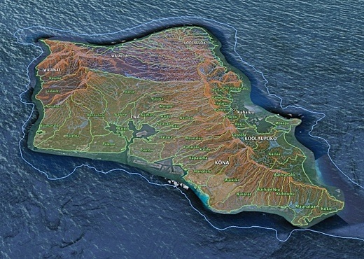
Image above: GoogleEarth view of Oahu's ahupuaa from the southeast. Click to enlarge. Created by Juan Wilson.
Author's Note on 2/1/12: To obtain the most recent ahupuaa and moku maps of Hawiian islands in PDFs of 24x36 plots, PNG files for publication, KMZ files for GoogleEarth or SHP files for GIS systems visit (http://www.islandbreath.org/mokupuni/mokupuni.html)
Links to the the island's Hawaiian land divisions for Google Earth is now available. Download the zip file below and expand it to a KML file. Open the resulting KML file with Google Earth to see the Ahupuaa and Moku of the island. The data includes elevation contour lines and all streams and rivers. The file is large for Google Earth and can take some several minutes to be up and running. Place this file in "MY PLACES" and save to disk:
If you do not have GoogleEarth you may also view this ineractive map with your web browser. Note you may be asked to download a GoogleEarth browser plug-in for your browser. The link to the embedded browser is below and has access to all other islands:
By Juan Wilson on 16 November 2010 for Island Breath -
(http://islandbreath.blogspot.com/2010/11/ka-mokupuni-o-oahu.html)
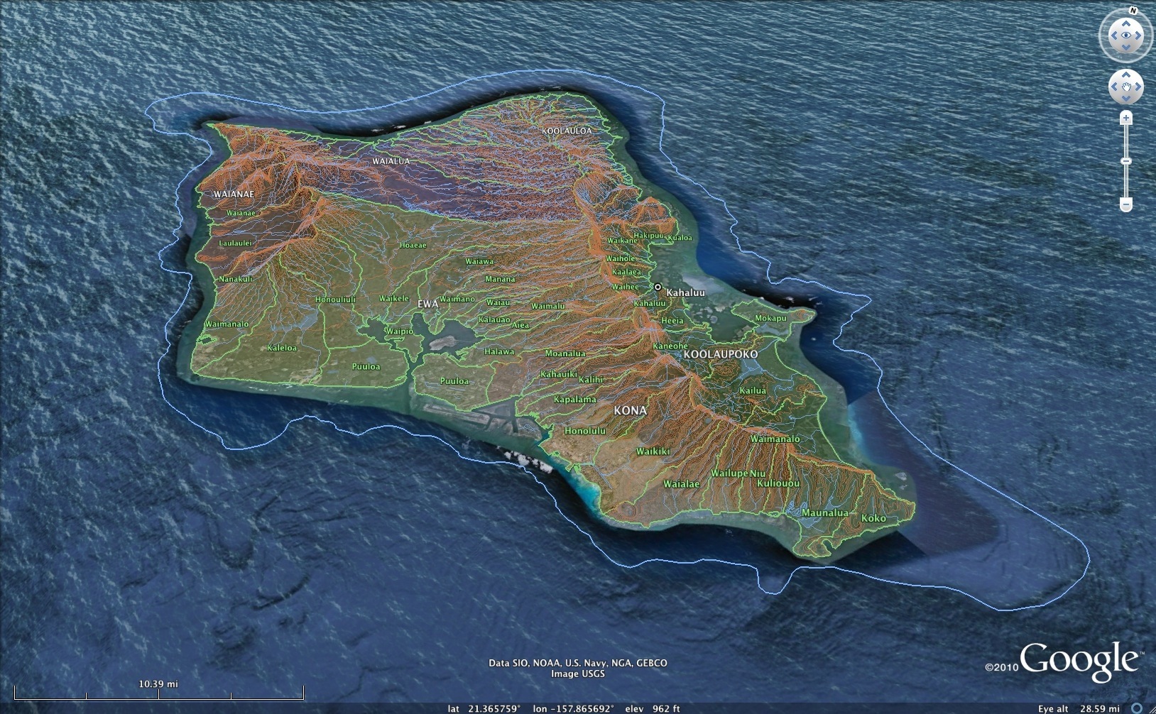
Image above: GoogleEarth view of Oahu's ahupuaa from the southeast. Click to enlarge. Created by Juan Wilson.
Author's Note on 2/1/12: To obtain the most recent ahupuaa and moku maps of Hawiian islands in PDFs of 24x36 plots, PNG files for publication, KMZ files for GoogleEarth or SHP files for GIS systems visit (http://www.islandbreath.org/mokupuni/mokupuni.html)
Links to the the island's Hawaiian land divisions for Google Earth is now available. Download the zip file below and expand it to a KML file. Open the resulting KML file with Google Earth to see the Ahupuaa and Moku of the island. The data includes elevation contour lines and all streams and rivers. The file is large for Google Earth and can take some several minutes to be up and running. Place this file in "MY PLACES" and save to disk:
If you do not have GoogleEarth you may also view this ineractive map with your web browser. Note you may be asked to download a GoogleEarth browser plug-in for your browser. The link to the embedded browser is below and has access to all other islands:
Ea O Ka Aina: Ka Mokupuni o Oahu 11/16/10
TOPOLOGICAL RULES
In creating the maps of ahupuaa in Hawaii we followed a specific set of guidelines. 1) Following the ridge lines of watershed lines conforming to 3D Google Earth modeling; USGS 7.5º contour maps, and to a lesser degree - state GIS 100' contour lines, watershed lines and shadow maps. 2) In some cases stream are boundaries between ahupuaa, as in the case of bifurcated valleys that join in a river near the ocean (as in the case on Kauai of Makaweli and Waimea joining a stone's throw from the shore).
Again Google 3D modeling was used to determine location as well as state GIS stream database. 3) In two rare incidences hyperbolic paraboloid surface joined four ahupuaa. That meant a positive and negative curve met (like a potatochip). See the fourway intersection between West and South Maui near Puunene. The intersection is the high point between Wailuku and Kihea. But that point is the lowpoint between the Haleakela and the peak above Waikapu. An even stranger situation occurs on the Big Island between Mauna Loa and Mauna Kea.
A similar potato chip surface occurs. However there is a wrinkle in it. from the saddle leading down to Hilo there is a ridge (positive curve) that flattens to neutral and goes negative (a valley). This is the reverse of two bifurcated valleys mentioned above. It the case where a stream running down a hill splits in two (as around somethin hard in its path).
There are no landlocked ahupuaa on our map projects of the islands. There are recessed ahupuaa as in the case of Haiku ahupuaa on Kauai and reaching the ocean only in the upper part of Nawiliwili harbor or Aiea ahpupuaa on Oahu that reaches the ocean only at the eastern lobe of Pearl Harbor. We generally have considered small landlocked ahupuaa shown on state maps to be ili or contractual/political divisions that are not geographically determinable.
NAME AND LOCATION RULES
We followed the following order of concerns in location and names of ahupuaa.
I am sure heat will be generated by those who review these maps and can't find their ahupuaa. I have been eager to hear such reports and find a way to determine how they can be incorporated into a better understanding of the Hawaiian environment and hoe the Hawaiians thrived for so long in it.
See also:
In creating the maps of ahupuaa in Hawaii we followed a specific set of guidelines. 1) Following the ridge lines of watershed lines conforming to 3D Google Earth modeling; USGS 7.5º contour maps, and to a lesser degree - state GIS 100' contour lines, watershed lines and shadow maps. 2) In some cases stream are boundaries between ahupuaa, as in the case of bifurcated valleys that join in a river near the ocean (as in the case on Kauai of Makaweli and Waimea joining a stone's throw from the shore).
Again Google 3D modeling was used to determine location as well as state GIS stream database. 3) In two rare incidences hyperbolic paraboloid surface joined four ahupuaa. That meant a positive and negative curve met (like a potatochip). See the fourway intersection between West and South Maui near Puunene. The intersection is the high point between Wailuku and Kihea. But that point is the lowpoint between the Haleakela and the peak above Waikapu. An even stranger situation occurs on the Big Island between Mauna Loa and Mauna Kea.
A similar potato chip surface occurs. However there is a wrinkle in it. from the saddle leading down to Hilo there is a ridge (positive curve) that flattens to neutral and goes negative (a valley). This is the reverse of two bifurcated valleys mentioned above. It the case where a stream running down a hill splits in two (as around somethin hard in its path).
There are no landlocked ahupuaa on our map projects of the islands. There are recessed ahupuaa as in the case of Haiku ahupuaa on Kauai and reaching the ocean only in the upper part of Nawiliwili harbor or Aiea ahpupuaa on Oahu that reaches the ocean only at the eastern lobe of Pearl Harbor. We generally have considered small landlocked ahupuaa shown on state maps to be ili or contractual/political divisions that are not geographically determinable.
NAME AND LOCATION RULES
We followed the following order of concerns in location and names of ahupuaa.
- If the moku or ahupuaa appeared on the 1838 map created by Simon Peter Kalama it was on our map. We followed Kalama's spelling and practice of not using diacritical marks.
- We used USGS 7.5 maps as a reference for place names and general location of ahupuaa. In some cases we found place names (no ahupuaa) conformed to Kalama ahupuaa names (such as on Oahu in moku Koolaupoko near Kaneohe Bay where the Marine Base is and Kalama notes the ahupuaa as Makapu (not to be confused with Makapuu point to the east.
- We used that Aha Kiole Advisory Committee Final Report as a reference for additional ahapuaa and moku. In cases where several listed ahupuaa had names the were enumerated as 1, 2, 3, 4, 5 or Ekahi, Eloha, Ekolu, Eha, Elima (as in the case on Hawaii of Kalaoa in Kona) we combined the ahupuaa into one. We also did not use generic names like Pahoehoe.
- We used Hawaii Government Survey maps (the earliest available we had access to) to help confirm USGS and Ahakiole names and locations.
I am sure heat will be generated by those who review these maps and can't find their ahupuaa. I have been eager to hear such reports and find a way to determine how they can be incorporated into a better understanding of the Hawaiian environment and hoe the Hawaiians thrived for so long in it.
See also:
For background see:
Ea O Ka Aina: Kauai & Niihau Mokupuni 4/16/10
Ea O Ka Aina: Kauai Aina Mapping 12/21/09
4 comments :
Where are the ahupuaa of Koolauloa and Waialua districts? Am I missing something?
L. Miliaulani
Aloha,
I was wondering, I am trying to find a specific place on the map....I was researching our family genealogy and on the 1930 census found our ohana living on Kapaakea District Road, Kalei Lane..I am not sure where this is. I was wondering if maybe this map would have it or if you would know where I may find it/locate it.
I also was wondering if there are maps available for the Koolauloa and Waialua areas of Oahu as well.
Your help is greatly appreciated.
Much Mahalo
Jeff Renaud
jemnzs@hotmail.com
Thats not what the Waiʻanae moku looks like. The moku extends all the way to the Koʻolau mountain range.
Aloha Kamanukea Kekoa,
My research for moku locations used Samuel Kalama's 1838 map of Hawaiian Islands. He was the first trained Hawaiian cartographer and created the last maps of Hawaiian moku and ahupuaa before the Great Mahele.
It seems clear from the coloring of his 1838 map that he did not think Waianae crossed the ridge of mountains that form its watersheds.
I disagree with some details of Kalama's maps. I see some shortcomings that were primarily omissions - particularly of smaller outer islands.
Also, I have particular problems with his divisions of Lanai that I see as particularly a result of historic politics (Kalama was from Maui). I suspect as well that he was unfamiliar with the north shore of Molokai.
However, combined with my other sources, Kalama is the foundation.
There may be a political, economic, military or even religious rational for dragging a corridor of Waianae across central Oahu, but that does not seem related to the biosphere, ecosystems or watersheds of the island.
Can you add some clarification to your position, beyond the fact that it appears on some maps that way?
To see that latest most comprehensive set of maps we have done visit http://www.islandbreath.org/mokupuni/mokupuni.html.
If you would like a copy of Kalama's work please email me at juan@islandbreath.org
IB Publisher
Post a Comment