SUBHEAD: Island Breath offers preview of Ahupuaa map of Kauai for use with GoogleEarth software.
By Juan Wilson on 6 December 2009 for Island Breath -
(http://islandbreath.blogspot.ca/2009/12/kauai-aina-on-google-earth.html)
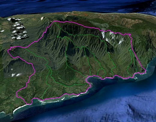
Image above: Screen shot of the Halelea Moku on the north shore of Kauai from GoogleEarth.
Since 2007 two Island Breath editors (Jonathan Jay and myself) have been working with the Aha Keole Council, and others to establish a map of the traditional Hawaiian land divisions of Moku and Ahupuaa (roughly bio-regions and major wastersheds respectively). In November 2008 we published our efforts and the Kauai Ahupuaa-Moku map became the Aha Keole Council representation of our islands land management areas. Since then we have refined those boundaries with further analysis and heavy use of GoogleEarth aerial photography and 3D topography.
We are now providing a preliminary release of this newer map for comments. If you have at recent version of the GoogleEarth application on your computer you can use a network link to the Kauai Moku-Ahupuaa map is availablefor downloading. Click on the link to the the ZIP file (091205KauaiAinaLink.zip).
After you have the ZIP file in your downloads folder (directory) unzip it and open the resulting KML file with GoogleEarth. When the link loads the Kauai data into GoogleEarth you can see the full details of the efforts to date. The IslandBreath server will automatically update the linked data as changes are made. Keep in mind that the these Moku and Ahupuaa of the island of Kauai are all separate entities an can be turned on or off independently. Moreover, you own information can be added, saved and shared. That information can be emailed to IslandBreath and be evaluated and incorporated into further detailing of the Kauai map.
Collaboration and many more things are possible with this flexible way of sharing knowledge. The details concerning the linked information is as follows: Use: Non-commercial use of this information is permitted if you credit those who organized and developed it. These Kauai land identifications were determine and put in GoogleEarth format by:
Juan Wilson - Architect/Planner with the assistance of:
Jonathan Jay - Designer in association with:
The Aha Kiole Council of Hawaii, and contributions from:
The Kauaian Institute. Criteria:
The Moku divisions are derived from Kalama Map (1837), applied over Hawai`i DBEDT GIS watershed data. The Ahupua`a divisions are based on traditional descriptions of location, with boundaries modified to follow watershed ridges and streams/rivers from DBEDT data. Where conflicts arose between traditional descriptions, DBEDT data and USGS 7.5º topological maps, we used Kauai Historical Society documents and coordination with GoogleEarth imaging and 3D countouring data.
Note:
Area names are written in standard ASCII text without traditional Hawiian accent marks. Area measurements and perimeter lengths are only approximations and will be updated shortly for greater accuracy. Users are responsible themselves for verifying the information in this file. All rights reserved. © 2009 by www.IslandBreath.org Revision 2.3 on 10 December 2009 Below is a preview of the GoogleEarth Ahupuaa layer of information (without Moku).
You will need the GoogleEarth plugin to see the map. You will see a link to the plugin if you do not have it. With the preview below you do not have the ability to turn on and of individual Ahupuaa and Moku but you can fly over the terrain and click on an Ahupuaa to see its current data or double-click on and Ahupuaa to zoom to its view from the ocean to the mountain.
See also:
Island Breath: Mokupuni O Hawaii Nei 1/30/12
Island Breath: Moku-Ahupuaa Divisions of Kauai 12/2/08
Island Breath: Kauai Land Use Sustainability Plan 11/1/08
Island Breath: Kauai Okana Districts 3/27/08
Island Breath: Kauai District Meeting 12/1/07
Island Breath: Kauai District Proposal 6/13/07
Island Breath: Planning by Hawaiian Land Divisions 4/23/06
By Juan Wilson on 6 December 2009 for Island Breath -
(http://islandbreath.blogspot.ca/2009/12/kauai-aina-on-google-earth.html)
Image above: Screen shot of the Halelea Moku on the north shore of Kauai from GoogleEarth.
Since 2007 two Island Breath editors (Jonathan Jay and myself) have been working with the Aha Keole Council, and others to establish a map of the traditional Hawaiian land divisions of Moku and Ahupuaa (roughly bio-regions and major wastersheds respectively). In November 2008 we published our efforts and the Kauai Ahupuaa-Moku map became the Aha Keole Council representation of our islands land management areas. Since then we have refined those boundaries with further analysis and heavy use of GoogleEarth aerial photography and 3D topography.
We are now providing a preliminary release of this newer map for comments. If you have at recent version of the GoogleEarth application on your computer you can use a network link to the Kauai Moku-Ahupuaa map is availablefor downloading. Click on the link to the the ZIP file (091205KauaiAinaLink.zip).
After you have the ZIP file in your downloads folder (directory) unzip it and open the resulting KML file with GoogleEarth. When the link loads the Kauai data into GoogleEarth you can see the full details of the efforts to date. The IslandBreath server will automatically update the linked data as changes are made. Keep in mind that the these Moku and Ahupuaa of the island of Kauai are all separate entities an can be turned on or off independently. Moreover, you own information can be added, saved and shared. That information can be emailed to IslandBreath and be evaluated and incorporated into further detailing of the Kauai map.
Collaboration and many more things are possible with this flexible way of sharing knowledge. The details concerning the linked information is as follows: Use: Non-commercial use of this information is permitted if you credit those who organized and developed it. These Kauai land identifications were determine and put in GoogleEarth format by:
Juan Wilson - Architect/Planner with the assistance of:
Jonathan Jay - Designer in association with:
The Aha Kiole Council of Hawaii, and contributions from:
The Kauaian Institute. Criteria:
The Moku divisions are derived from Kalama Map (1837), applied over Hawai`i DBEDT GIS watershed data. The Ahupua`a divisions are based on traditional descriptions of location, with boundaries modified to follow watershed ridges and streams/rivers from DBEDT data. Where conflicts arose between traditional descriptions, DBEDT data and USGS 7.5º topological maps, we used Kauai Historical Society documents and coordination with GoogleEarth imaging and 3D countouring data.
Note:
Area names are written in standard ASCII text without traditional Hawiian accent marks. Area measurements and perimeter lengths are only approximations and will be updated shortly for greater accuracy. Users are responsible themselves for verifying the information in this file. All rights reserved. © 2009 by www.IslandBreath.org Revision 2.3 on 10 December 2009 Below is a preview of the GoogleEarth Ahupuaa layer of information (without Moku).
You will need the GoogleEarth plugin to see the map. You will see a link to the plugin if you do not have it. With the preview below you do not have the ability to turn on and of individual Ahupuaa and Moku but you can fly over the terrain and click on an Ahupuaa to see its current data or double-click on and Ahupuaa to zoom to its view from the ocean to the mountain.
See also:
Island Breath: Mokupuni O Hawaii Nei 1/30/12
Island Breath: Moku-Ahupuaa Divisions of Kauai 12/2/08
Island Breath: Kauai Land Use Sustainability Plan 11/1/08
Island Breath: Kauai Okana Districts 3/27/08
Island Breath: Kauai District Meeting 12/1/07
Island Breath: Kauai District Proposal 6/13/07
Island Breath: Planning by Hawaiian Land Divisions 4/23/06
1 comment :
Very cool.
Post a Comment