SUBHEAD: The island of Hawaii has been examined for its historical ahupuaa land divisions.
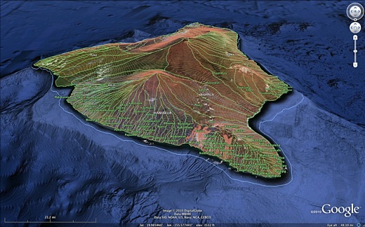
Image above: GoogleEarth screenshot of Hawaii ahupuaa divisions. Created by Juan Wilson.
By Juan Wilson on 25 September 2010 for Island Breath -
(http://islandbreath.blogspot.com/2010/09/mokupuni-o-hawaii.html)
Author's Note on 2/1/12: To obtain the most recent ahupuaa and moku maps of Hawiian islands in PDFs of 24x36 plots, PNG files for publication, KMZ files for GoogleEarth or SHP files for GIS systems visit (http://www.islandbreath.org/mokupuni/mokupuni.html)
Links to the the island's Hawaiian land divisions for Google Earth is now available. Download the zip file below and expand it to a KML file. Open the resulting KML file with Google Earth to see the Ahupuaa and Moku of the island. The data includes elevation contour lines and all streams and rivers. The file is large for Google Earth and can take some several minutes to be up and running. Place this file in "MY PLACES" and save to disk:
Mokupuni O Hawaii
(http://www.islandbreath.org/2010Year/09/100925Hawaii/100925Hawaii.zip)
If you do not have GoogleEarth you may also view this ineractive map with your web browser. Note you may be asked to download a GoogleEarth browser plug-in for your browser. The link to the embedded browser is below and has access to all other islands:
Ea O Ka Aina: Ka Mokupuni o Hawaii 9/25/10
For the last few years I, with the help of others, including Jonathan Jay and the late Jean Ileialoha Beniamina, have been trying to identify the names and locations of the historic land divisions in Kauai Nei used by Hawaiians to sustainably manage land for centuries.
Since this spring that work has been expanded to include all the eight main islands in the Hawaiian chain. The Western Pacific Regional Fisheries Management Council has contracted with IslandBreath.org to map the moku (bioregional) and ahupuaa (watershed) divisions throughout the state.
On June 1st, 2010, we completed a submission that included the latest version of our maps of Kauai and Niihau. Since then we have been working on Maui Nei (Maui, Molokai, Lanai, Kahoolawe). On August 1st we will deliver that submission with a newly revised version Kauai and Niihau. We are scheduled to submit the Big Island of Hawaii on October 1st 2010, and Oahu on December 1st 2010. We will share the results on this website. An interactive GoogleEarth website embed of each island will be provided as well as a reproducible image.
Research indicates that historically there have been changes in the mapping of ahupuaa. It depended not only on the cultural, historic and geographic knowledge of the cartographer, but the motivation behind doing the map. It is likely that the need to manage resources increased as they were utilized by an expanding population.
Certainly, over the centuries how they were managed changed. In time kapu (taboo laws) were enacted and taxes based on ahupuaa resources were collected. After European contact, in the mid 19th century, the concept private property was accepted and it soon secured a foothold for widespread plantation agriculture.
Water was diverted out of the valleys and the ahupua land use concept fell into disuse. In some places, like Maui's Hamakuapoko Moku (From the airport near Kahaluhi harbor to Haiku) the land was so aggressively managed by western plantation owners that ditches dams and reservoirs completely erased original streambeds. Hawaiian place names disappeared and subsequent maps of Maui had no Ahupuaa names.
Instead we have Sprecklesville and Baldwin Avenue. I have attempted to create a set of maps that have moku and ahupuaa covering all of each island. I have tried to use the earliest printed source material available as a foundation. I have tried to eliminate the distortions caused by conquest and war. The boundaries for the land divisions is strictly based on topological features of the land: shorelines, streambeds, and mountain ridges.
Like the informer Deep Throat advised Woodward and Bernstein to the bottom of Richard Nixon's machinations; "Follow the money!" In the case of Ahupuaa that advice would be "Follow the water!" Note: Depending on the island, it may take several seconds to a minute for the data to load. The following is the content of the "splash" page for the Kauai Nei GoogleEarth Maps.
Ea O Ka Aina: Na Mokupuni O Maui Nei 8/1/10
On June 1st, 2010, we completed a submission that included the latest version of our maps of Kauai and Niihau. Since then we have been working on Maui Nei (Maui, Molokai, Lanai, Kahoolawe). On August 1st we will deliver that submission with a newly revised version Kauai and Niihau. We are scheduled to submit the Big Island of Hawaii on October 1st 2010, and Oahu on December 1st 2010. We will share the results on this website. An interactive GoogleEarth website embed of each island will be provided as well as a reproducible image.
Research indicates that historically there have been changes in the mapping of ahupuaa. It depended not only on the cultural, historic and geographic knowledge of the cartographer, but the motivation behind doing the map. It is likely that the need to manage resources increased as they were utilized by an expanding population.
Certainly, over the centuries how they were managed changed. In time kapu (taboo laws) were enacted and taxes based on ahupuaa resources were collected. After European contact, in the mid 19th century, the concept private property was accepted and it soon secured a foothold for widespread plantation agriculture.
Water was diverted out of the valleys and the ahupua land use concept fell into disuse. In some places, like Maui's Hamakuapoko Moku (From the airport near Kahaluhi harbor to Haiku) the land was so aggressively managed by western plantation owners that ditches dams and reservoirs completely erased original streambeds. Hawaiian place names disappeared and subsequent maps of Maui had no Ahupuaa names.
Instead we have Sprecklesville and Baldwin Avenue. I have attempted to create a set of maps that have moku and ahupuaa covering all of each island. I have tried to use the earliest printed source material available as a foundation. I have tried to eliminate the distortions caused by conquest and war. The boundaries for the land divisions is strictly based on topological features of the land: shorelines, streambeds, and mountain ridges.
Like the informer Deep Throat advised Woodward and Bernstein to the bottom of Richard Nixon's machinations; "Follow the money!" In the case of Ahupuaa that advice would be "Follow the water!" Note: Depending on the island, it may take several seconds to a minute for the data to load. The following is the content of the "splash" page for the Kauai Nei GoogleEarth Maps.
Ka Mokupuni O Hawaii Big Island
AHA KIOLE ADVISORY COMMITTEE of the Western Pacific Regional Fishery Management Council All rights reserved. © 2010 by the Aha Kiole Advisory Committee & www.IslandBreath.org
• Revision 1.0.0 on 1 October 2010 These Kauai land identifications were delineated and converted to GIS and GoogleEarth KMZ format by: Juan Wilson - Architect/Planner with the assistance of Jonathan Jay
Criteria: Simon Peter Kalama Maps (1837, 1838) of moku and ahupuaa were used as a foundation for these map boundaries. All moku and ahupuaa shown on Kalama maps are included in this project. The source for the 1837 Kalama map was the U.S. Librabry of Congress. The 1838 Kalama map was made available from the British Royal Geographic Society. Note, area names are written without traditional Hawaiian diacritical marks, as was the practice of Kalama. The divisions are based also on traditional descriptions of location, with boundaries modified to follow watershed ridges and streams/rivers from available topography.
Procedure: After identifying Kalama ahapuaa and moko locarions and names the Aha Kiole Advisary Committee Final Report was compared with State of Hawaii DBEDT GIS files (Streams, water bodies and elevation contours) and added to GoogleEarth aerial photography and 3D elevation data to determine final ahupuaa and moku names locations and boundaries. Sources: A two letter code for the sources of each ahupuaa can be seen when clicking within its boundary. They are: (sk) Simon Peter Kalama "Na Mokupuni O Hawaii Nei" maps printed in 1837 and 1838, (ak) Aha Kiole Advisory Committee Final Report 12/18/08, (gs) United States Geological Survey Maps 7.5º topographic maps), (ab) W. D. Alexander island surveys for the Hawaiian Government.See also:
Ea O Ka Aina: Na Mokupuni O Maui Nei 8/1/10
For background see:
Ea O Ka Aina: Kauai & Niihau Mokupuni 4/16/10
Ea O Ka Aina: Kauai Aina Mapping 12/21/09
sland Breath: Kauai Moku District Meeting 3/11/08
.
6 comments :
I note that Kahului is in the "Hahului" ahupua`a. Is this a typo or accurate?
I should have posted this comment under the Maui locations.. My error.
Aloha Anonymous,
You are correct. Typo! I believe the latest version of Maui that has been corrected. Check out https://public.me.com/juanwilson
Hey,
Better yet, check out http://www.islandbreath.org/mokupuni/mokupuni.html
Juan
Aloha, Iʻm not sure what the purpose of these maps is, or what exactly they are supposed to reflect, having just stumbled upon this from a google search for ahupuaʻa maps of Hawaiʻi Island. Upon looking at the Ahupuaʻa map of Hawaiʻi island, however, it appears to me that the shapes and sizes of several ahupuaʻa are radically different than what Iʻve previously seen, such as Kahuku in Kaʻū, Humuʻula in Hilo, and Keauhou in Kona. Also... some ahupuaʻa seem to have disappeared altogether, such as Mohokeaiki and nui, as well as Makaka in the Kaʻū district... How did you guys come to these conclusions in mapping this island? - Noah Gomes - njgomes@hawaii.edu
Aloha Anonymous,
Have you read the CRITERIA, PROCEDURE and SOURCES from above? If not, there's a good beginning.
The purpose of the work was to develop a comprehensive set of maps of all the islands delineating the moku and ahupuaa of each using the best historic and geographical resources available.
I would be glad to have a conversation with you about what we did and why.
For the Big Island we believe that many layers of politics and local rivalries distorted the philosophy of the ahupuaa. As a result we combined many of the numbered subdivisions of ahupuaa (ekahi, elua, ekolu, eha,elima)as well as some of the major and minor subdivisions (iki and nui).
You can email me by clicking on my name at the top right of this posted article.
Juan Wilson
IB Publisher.
Post a Comment