SUBHEAD: Discerning the evidence, researching the historic record, channeling the prehistoric, all in order to find sustainability.
By Juan Wilson on 2 June 2010 for Island Breath -
(http://islandbreath.blogspot.com/2010/06/na-mokupuni-o-hawaii-nei.html)

Image above: Latest map of moku and ahupuaa of Kauai. Click to enlarge.
In the last month we (myself and Jonathan Jay) have taken on the project of mapping the entire inhabited chain of the Hawaiian Islands to make a determination of their major indigenous major land divisions. This project is estimated to last until the end of this year.
A Bit of Background
This effort began back in 2006 with a districting of Kauai and resulted in reasonable map in December of 2009. Early this year we continued to refine the Kauai map and began mapping Niihau. By mid April we achieved what we think a reasonable maps for both islands.
Of course they are not definitive, and we continue to modify these maps as an ongoing process.

Image above: Detail of Kauai from 1838 map by S. P. Kalama.
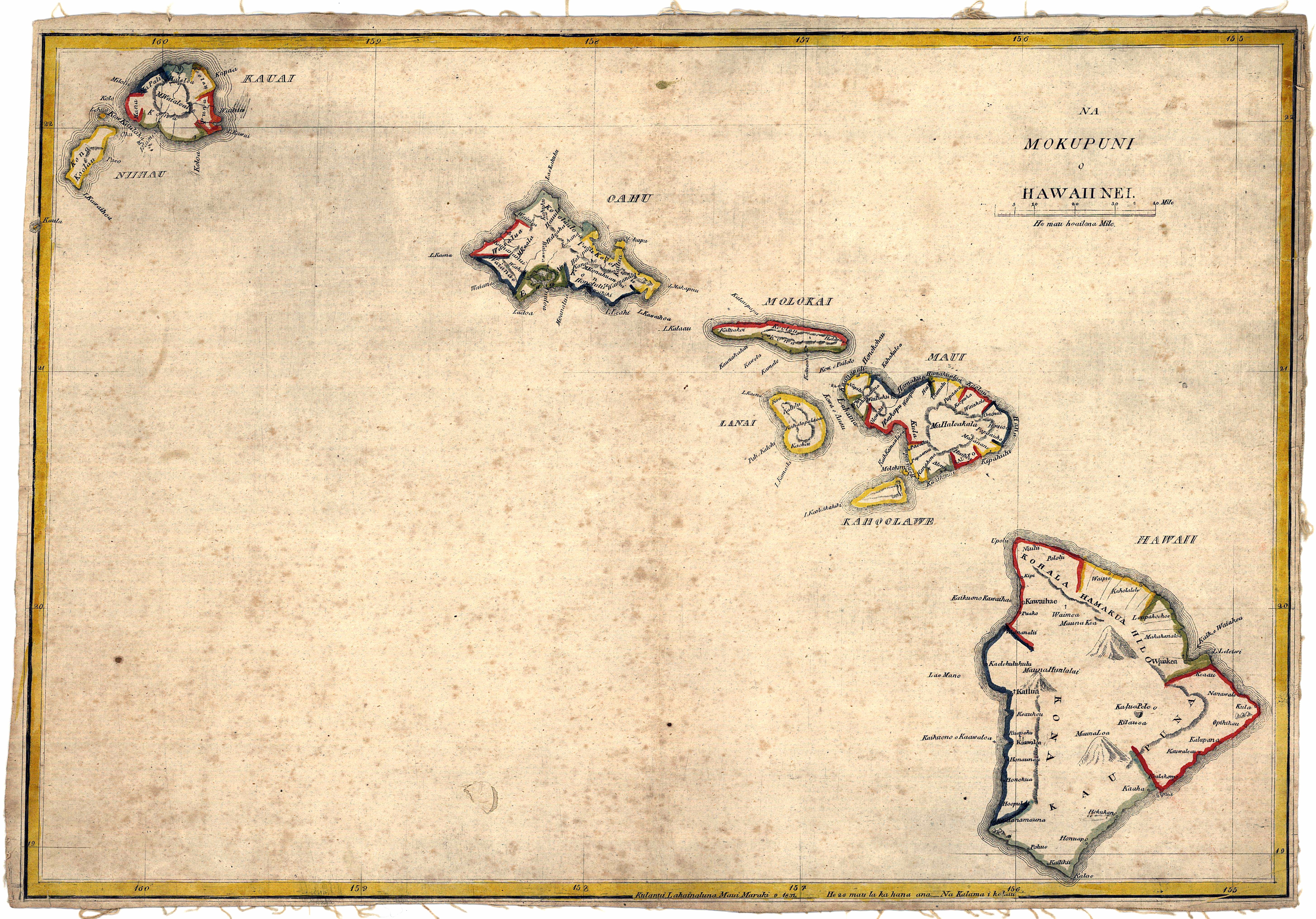
A foundation for our work has been the 1837 and 1838 maps by Simon P. Kalama of the Hawaiian Islands (Na Mokupuni O Hawaii Nei). The latter was achieved after much research by Jennifer Dove Mylett, a librarian on Oahu, who discovered the only known complete 1838 map in an archive of the British Royal Geographic Society in London (available from the RGS for $75).
It is the only one known to have been created by a Hawaiian showing the ahupuaa divisions of Hawaii Nei before the advent of the Great Mahele and the introduction of private property.
Note in the map above there are six moku on Kauai: Mana, Kona, Puna, Koolau, Halelea, Napali. There are fewer ahupuaa noted than are traditionally counted on Kauai. Kalama worked from Lahaina, on Maui, and probably had less detailed knowledge of other outer islands.
His most detailed knowledge seems to come from the areas closest to him and most populated. The Kalama map was printed on the first printing press in Hawaii at the Lahainaluna Seminary.
It appears to be made in sections colored by hand and pieced together. This conforms with a partial map in the hands of the U.S. Library of Congress, the only other 1838 map artifact we know of.
It is notable that the islands of Oahu, Kauai and Niihau were only colored in yellow and blue. There is no green or red as there is on the Big Island or in the Maui group. Did the map maker literally run out of colored ink? It begs to ask - how many of these maps were ever created?
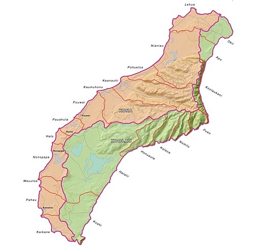
Image above: Map of moku and ahupuaa of Niihau as of 6/1/10. Click to enlarge. See below for latest.
New Scope of Work
Because of our modest success in mapping Kauai Nei we have been commissioned by the Aha Kiole Advisory Committee of the Western Pacific Regional Fishery Management Council to map all the islands between Hawaii and Niihau.
Our intent is to gather what knowledge their is about traditional Hawaiian land management and apply it to modern geographical tools: Geographical Information Systems, Aerial Orthophotography, Cartographic Data, GoogleEarth, etc. We are trying to use the new information to "fill in the blanks".
By that I mean we have in mind adjusting previous "line of sight" and verbal descriptions of ahupuaa and moku areas to the best information available about ecology, watersheds, sustainability practice that could define bioregional boundaries we need to realize to best live in Hawaii. Our assumption is that the kanaka maoli had an idea of how to do just that.
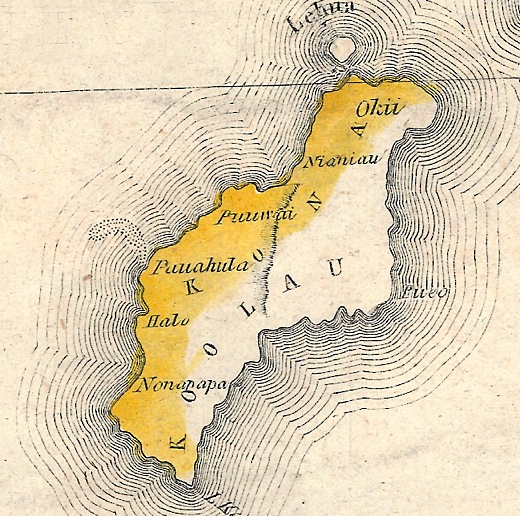
Image above: Detail of Niihau from 1838 map by S. P. Kalama.
Cloudy Past of Conquest and Privatization
One thing we think we have discovered in (even the earliest S. P. Kalama maps) is the loss natural bioregional clarity due to conquest between islands, contact with Ango-Americans, and subsequent unification of all Hawaii in Kamehameha through the use of western technology. We hope to sift out out what is the natural order if each island had a degree of self-reliance and autonomy. The successful completion of these maps will, we hope, be a step towards sustainability and sovereignty for Hawaii. Our next phase of work is to begin work on Maui Nei (Maui, Molokai, Lanai and Kahoolawe. Below is the modified map that now includes a Puna Moku on Niihau.
 Image above: Map of Niihau with Puna district as per Ileialoha Beniamina 7/1/10. Click to enlarge.
IB Publisher's Note: This article has been updated with links to high resolution images of S. P. Kalama's 1837 and 1838 maps of Na Mokupuni O Hawaii Nei (the Hawaiian Islands). These were the only comprehensive maps known created by a Hawaiian to map the islands before the Great Mahele and the following introduction of private land ownership.

Map above: Kalama Map of 1837. Click to enlarge to 5821 × 4067 pixels.

Map above: Kalama Map of 1838. Click to enlarge to 13236 × 8698 pixels.
See also:
Ea O Ka Aina: Memories of Ileialoha Beniamina 7/17/10
Ea O Ka Aina: Kauai & Niihau Mokupuni 4/16/10
Ea O Ka Aina: Niihau & Kauai Mokupuni 3/3/10
Ea O Ka Aina: Kauai Aina Mapping 12/21/09
Ea O ka Aina: Kauai on GoogleEarth 12/6/09
Island Breath: Moku-Ahupuaa Divisions of Kauai 12/2/08
Island Breath: Kauai Moku District Meeting 3/11/08
Island Breath: Kauai Sustainability Land Use Plan 11/11/07
.
By Juan Wilson on 2 June 2010 for Island Breath -
(http://islandbreath.blogspot.com/2010/06/na-mokupuni-o-hawaii-nei.html)

Image above: Latest map of moku and ahupuaa of Kauai. Click to enlarge.
In the last month we (myself and Jonathan Jay) have taken on the project of mapping the entire inhabited chain of the Hawaiian Islands to make a determination of their major indigenous major land divisions. This project is estimated to last until the end of this year.
A Bit of Background
This effort began back in 2006 with a districting of Kauai and resulted in reasonable map in December of 2009. Early this year we continued to refine the Kauai map and began mapping Niihau. By mid April we achieved what we think a reasonable maps for both islands.
Of course they are not definitive, and we continue to modify these maps as an ongoing process.
Image above: Detail of Kauai from 1838 map by S. P. Kalama.
A foundation for our work has been the 1837 and 1838 maps by Simon P. Kalama of the Hawaiian Islands (Na Mokupuni O Hawaii Nei). The latter was achieved after much research by Jennifer Dove Mylett, a librarian on Oahu, who discovered the only known complete 1838 map in an archive of the British Royal Geographic Society in London (available from the RGS for $75).
It is the only one known to have been created by a Hawaiian showing the ahupuaa divisions of Hawaii Nei before the advent of the Great Mahele and the introduction of private property.
Note in the map above there are six moku on Kauai: Mana, Kona, Puna, Koolau, Halelea, Napali. There are fewer ahupuaa noted than are traditionally counted on Kauai. Kalama worked from Lahaina, on Maui, and probably had less detailed knowledge of other outer islands.
His most detailed knowledge seems to come from the areas closest to him and most populated. The Kalama map was printed on the first printing press in Hawaii at the Lahainaluna Seminary.
It appears to be made in sections colored by hand and pieced together. This conforms with a partial map in the hands of the U.S. Library of Congress, the only other 1838 map artifact we know of.
It is notable that the islands of Oahu, Kauai and Niihau were only colored in yellow and blue. There is no green or red as there is on the Big Island or in the Maui group. Did the map maker literally run out of colored ink? It begs to ask - how many of these maps were ever created?

Image above: Map of moku and ahupuaa of Niihau as of 6/1/10. Click to enlarge. See below for latest.
New Scope of Work
Because of our modest success in mapping Kauai Nei we have been commissioned by the Aha Kiole Advisory Committee of the Western Pacific Regional Fishery Management Council to map all the islands between Hawaii and Niihau.
Our intent is to gather what knowledge their is about traditional Hawaiian land management and apply it to modern geographical tools: Geographical Information Systems, Aerial Orthophotography, Cartographic Data, GoogleEarth, etc. We are trying to use the new information to "fill in the blanks".
By that I mean we have in mind adjusting previous "line of sight" and verbal descriptions of ahupuaa and moku areas to the best information available about ecology, watersheds, sustainability practice that could define bioregional boundaries we need to realize to best live in Hawaii. Our assumption is that the kanaka maoli had an idea of how to do just that.
Image above: Detail of Niihau from 1838 map by S. P. Kalama.
Cloudy Past of Conquest and Privatization
One thing we think we have discovered in (even the earliest S. P. Kalama maps) is the loss natural bioregional clarity due to conquest between islands, contact with Ango-Americans, and subsequent unification of all Hawaii in Kamehameha through the use of western technology. We hope to sift out out what is the natural order if each island had a degree of self-reliance and autonomy. The successful completion of these maps will, we hope, be a step towards sustainability and sovereignty for Hawaii. Our next phase of work is to begin work on Maui Nei (Maui, Molokai, Lanai and Kahoolawe. Below is the modified map that now includes a Puna Moku on Niihau.
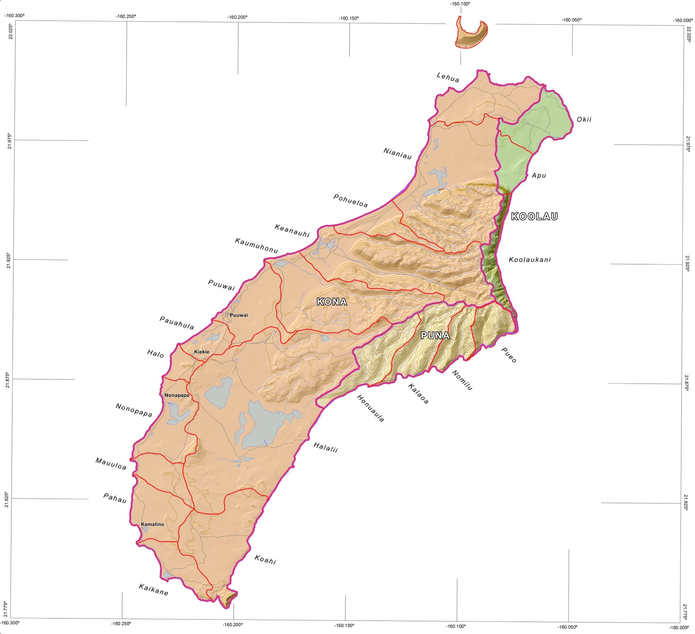 Image above: Map of Niihau with Puna district as per Ileialoha Beniamina 7/1/10. Click to enlarge.
 IB Publisher's Note: This article has been updated with links to high resolution images of S. P. Kalama's 1837 and 1838 maps of Na Mokupuni O Hawaii Nei (the Hawaiian Islands). These were the only comprehensive maps known created by a Hawaiian to map the islands before the Great Mahele and the following introduction of private land ownership.
Map above: Kalama Map of 1837. Click to enlarge to 5821 × 4067 pixels.
Map above: Kalama Map of 1838. Click to enlarge to 13236 × 8698 pixels.
See also:
Ea O Ka Aina: Memories of Ileialoha Beniamina 7/17/10
Ea O Ka Aina: Kauai & Niihau Mokupuni 4/16/10
Ea O Ka Aina: Niihau & Kauai Mokupuni 3/3/10
Ea O Ka Aina: Kauai Aina Mapping 12/21/09
Ea O ka Aina: Kauai on GoogleEarth 12/6/09
Island Breath: Moku-Ahupuaa Divisions of Kauai 12/2/08
Island Breath: Kauai Moku District Meeting 3/11/08
Island Breath: Kauai Sustainability Land Use Plan 11/11/07
.
6 comments :
The artist of the 1837 and 1838 maps was Simon Peter Kalama not Samuel P. Kalama
Aloha Anonymous,
Great thanks for you correction. It seems as if almost all reference to Kalama is as "S.P.". No one, other than you has found my error, and I cannot find any source at this time for "Samuel". Even in obtaining an image of Kalama's 1838 map from the British Royal Geographic Society I ran into no conflict of names.
Mahalo
Juan Wilson
IB Publisher
Very interested in where you acquired the images from Kalama map? I checked the Royal Geographical Society, and wasn't able to find where to purchase a print of the original. Any help with where I might find digital copies of the map would be much appreciated.
Aloha anonymous #2,
My daughter-in-law is a librarian. She found that the Royal Geographic Society had a copy of the map. I contacted a woman in the cartographic department told her about the mapping project I was doing for NOAA/WesPac thru the Aha Kiole Advisory Committee. She was able to provide me a digital copy on a CD for $75.
I do not think this is an item generally available for sale from the RGS.
What use do you have for the map?
Juan Wilson
Publisher of islandbreath.org
I am an antique map enthusiast. I don't have as many as I'd like, but would love to keep collecting. In the meantime, I really like the Kalama map of the islands. I would like to purchase or create a print of the map, and the one that I can get from the LoC is only 2 of the panels. Thanks!
Thanks so much for posting the high res images of the maps!
Post a Comment