Showing posts with label Aquifer. Show all posts

The Greatest US Water Crisis

SUBHEAD: Much of the American West was once a desert, and much of it is now turning back into a desert. 

By Mcichael Snyder on  12 May 2015 force Economic Collapse Blog -
(http://theeconomiccollapseblog.com/archives/the-greatest-water-crisis-in-the-history-of-the-united-states)


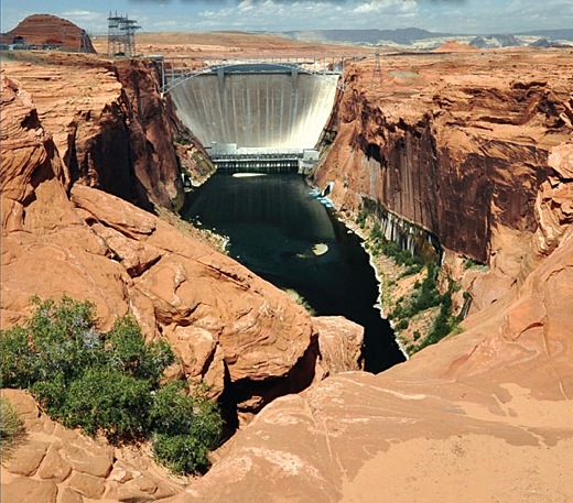
Image above: Detail of book cover for "Dam Nation" by Steven Grace about how water shaped the West and will determine its future. From (http://www.motherearthnews.com/nature-and-environment/ogallala-aquifer-ze0z1305zwar.aspx).

What are we going to do once all the water is gone?  Thanks to the worst drought in more than 1,000 years, the western third of the country is facing the greatest water crisis that the United States has ever seen.

Lake Mead is now the lowest that it has ever been since the Hoover Dam was finished in the 1930s, mandatory water restrictions have already been implemented in the state of California, and there are already widespread reports of people stealing water in some of the worst hit areas.

But this is just the beginning.  Right now, in a desperate attempt to maintain somewhat “normal” levels of activity, water is being pumped out of the ground in the western half of the nation at an absolutely staggering pace.

Once that irreplaceable groundwater is gone, that is when the real crisis will begin.  If this multi-year drought stretches on and becomes the “megadrought” that a lot of scientists are now warning about, life as we know it in much of the country is going to be fundamentally transformed and millions of Americans may be forced to find somewhere else to live.

Simply put, this is not a normal drought.  What the western half of the nation is experiencing right now is highly unusual.  In fact, scientists tell us that California has not seen anything quite like this in at least 1,200 years
Analyzing tree rings that date back to 800 A.D. — a time when Vikings were marauding Europe and the Chinese were inventing gunpowder — there is no three-year period when California’s rainfall has been as low and its temperatures as hot as they have been from 2012 to 2014, the researchers found.
Much of the state of California was once a desert, and much of it is now turning back into a desert.  The same thing can also be said about much of Arizona and much of Nevada.  We never really should have built massive, sprawling cities such as Las Vegas and Phoenix in the middle of the desert.  But the 20th century was the wettest century for western North America in about 1,000 years, and we got lulled into a false sense of security.

At this point, the water level in Lake Mead has hit a brand new record low, and authorities are warning that official water rationing could soon begin for both Arizona and Nevada…
Lake Mead, the largest reservoir in the US, has hit its lowest level ever. Feeding California, Nevada and Arizona, it can hold a mind-boggling 35 cubic kilometres of water. But it has been many years since it was at capacity, and the situation is only getting worse.

“We’re only at 38 percent full. Lake Mead hasn’t been this low since we were filling it in the 1930s,” said a spokeswoman for the US Bureau of Reclamation in Las Vegas.
If it gets much lower – and with summer approaching and a dwindling snowpack available to replenish it, that looks likely – official rationing will begin for Arizona and Nevada.
And did you know that the once mighty Colorado River no longer even reaches the ocean?  Over 40 million people depend upon this one river, and because the Colorado is slowly dying an enormous amount of water is being pumped out of the ground in a crazed attempt to carry on with business as usual
The Colorado River currently supplies water to more than 40 million people from Denver to Los Angeles (as well as Las Vegas, Phoenix, Tucson, San Diego, Salt Lake City, Albuquerque, and Santa Fe—none of which lie directly on the river). According to one recent study, 16 million jobs and $1.4 trillion in annual economic activity across the West depend on the Colorado.

As the river dries up, farmers and cities have turned to pumping groundwater. In just the last 10 years, the Colorado Basin has lost 15.6 cubic miles of subsurface freshwater, an amount researchers called “shocking.” Once an official shortage is declared, Arizona farmers will increase their rate of pumping even further, to blunt the effect of an anticipated sharp cutback.
The same kind of thing is going on in the middle part of the country.  Farmers are pumping water out of the rapidly shrinking Ogallala Aquifer so fast that a major crisis in the years ahead is virtually guaranteed
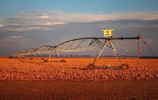
Farther east, the Ogallala Aquifer under the High Plains is also shrinking because of too much demand. When the Dust Bowl overtook the Great Plains in the 1930s, the Ogallala had been discovered only recently, and for the most part it wasn’t tapped then to help ease the drought. But large-scale center-pivot irrigation transformed crop production on the plains after World War II, allowing water-thirsty crops like corn and alfalfa for feeding livestock.

But severe drought threatens the southern plains again, and water is being unsustainably drawn from the southern Ogallala Aquifer. The northern Ogallala, found near the surface in Nebraska, is replenished by surface runoff from rivers originating in the Rockies. But farther south in Texas and New Mexico, water lies hundreds of feet below the surface, and does not recharge.

Sandra Postel wrote here last month that the Ogallala Aquifer water level in the Texas Panhandle has dropped by up to 15 feet in the past decade, with more than three-quarters of that loss having come during the drought of the past five years. A recent Kansas State University study said that if farmers in Kansas keep irrigating at present rates, 69 percent of the Ogallala Aquifer will be gone in 50 years.
At one time, most of us took water completely for granted.

But now that it is becoming “the new oil”, people are starting to look at water much differently.  Sadly, this even includes thieves
With the state of California mired in its fourth year of drought and a mandatory 25 percent reduction in water usage in place, reports of water theft have become common.
In April, The Associated Press reported that huge amounts of water went missing from the Sacramento-San Joaquin Delta and a state investigation was launched. The delta is a vital body of water, serving 23 million Californians as well as millions of farm acres, according to the Association for California Water Agencies.

The AP reported in February that a number of homeowners in Modesto, California, were fined $1,500 for allegedly taking water from a canal. In another instance, thieves in the town of North San Juan stole hundreds of gallons of water from a fire department tank.
In case you are wondering, of course this emerging water crisis is going to deeply affect our food supply.  More than 40 percent of all our fruits and vegetables are grown in the state of California, so this drought is going to end up hitting all of us in the wallet one way or another.

And this water crisis is not the only major threat that our food supply is facing at the moment.  A horrific outbreak of the bird flu has already killed more than 20 million turkeys and chickens, and the price of eggs has already gone up substantially
The cost of a carton of large eggs in the Midwest has jumped nearly 17 percent to $1.39 a dozen from $1.19 since mid-April when the virus began appearing in Iowa’s chicken flocks and farmers culled their flocks to contain any spread.

A much bigger increase has emerged in the eggs used as ingredients in processed products like cake mix and mayonnaise, which account for the majority of what Iowa produces. Those eggs have jumped 63 percent to $1.03 a dozen from 63 cents in the last three weeks, said Rick Brown, senior vice president of Urner Barry, a commodity market analysis firm.
Most of us are accustomed to thinking of the United States as a land of seemingly endless resources, but now we are really starting to bump up against some of our limitations.

Despite all of our technology, the truth is that we are still exceedingly dependent on the weather patterns that produce rain and snow for us.

For years, I have been warning that Dust Bowl conditions would be returning to the western half of the country, and thanks to this multi-year drought we can now see it slowly happening all around us.

And if this drought continues to stretch on, things are going to get worse than this.

Much worse.

.

Ugly show at the Cow Palace

SUBHEAD: What did we learn from Hawaii Dairy Farm open house? How guile, disinformation, issue avoidance works.

By Diane de Vries on 27 February 2015 in TGI -
(http://thegardenisland.com/news/opinion/guest/what-did-we-learn-from-hdf-open-house/article_a46ced8e-be4b-11e4-bf8f-73d0a52e287a.html)


Image above: A herd of cattle pause in the Cow Palace parking lot after their arrival for the 63rd annual Grand National Rodeo, Horse & Stock Show in Daly City, California on Thursday, April 3, 2008. From (http://www.sfgate.com/bayarea/article/Cow-Palace-won-t-be-sold-after-all-3218092.php).

[IB Publisher's note: Been through this on many occasions when the development speculators bring in their consultants to do a smoke-and-mirror show for the "public".  It's all public relations and eye-wash. They are merely there to grease the skids on the next big ugly thing coming our way. This is another mess to blame on Pierre Omidyer.]


I don’t know about the rest of you but Thursday night’s dairy farm meeting at Koloa School cafeteria left me angry, disappointed and completely frustrated.

I went with the hope that some of my concerns would be answered or that I would feel reassured the dairy personnel or their contractor, Group 70 International, had things under control and knew what they were doing. Instead, we received no new information but were asked to break into groups and walk to tables set up around the periphery of the room where we could have our questions “addressed.”


Were they addressed? Not at all. Instead, Group 70 personnel stood with sharpie pens in hand, next to large white note pads and wrote down the questions people were asking. There were no answers at all. In fact, the engineer supposedly responsible for the dairy’s Waste Management Plan (WMP), was not even able to say how many cows would be grazing per paddock. How could he have been the person who “designed the WMP” as the head of Group 70 told the audience?

A copy of the dairy’s current WMP is on friendsofmahaulepu.org. That plan specifies the number of acres in each paddock, the herd size and the plan’s design to rotate 105-115 cows per paddock. When asked the question about how many cows HDF plans to graze per acre, the engineer told all who were clustered around that he would have to “look into that.” And so it went.

The only thing that happened was that people with black sharpies wrote down questions to be addressed, hopefully, in the draft Environmental Impact Statement at some future unspecified date.

So no one heard any confirmation of the total cow waste to be produced, how the surrounding streams and nearby ocean are to be protected from contamination by runoff with irrigation or rains or storms, and we heard nothing about how this farm meets any sustainable criteria when the dairy plans to import grain and export the milk to be processed elsewhere by another company before it is fit for consumption by the public somewhere.

The most unsettling aspect of this meeting was the fact that the Group 70 International architects and engineers seemed to be unaware of the concerns people were voicing as they made remarks like, “Oh, you’re concerned about contamination of the drinking water in the Koloa Wells, we’ll write that down.”

As I traveled from station to station watching the faces of so many concerned members of our community I found myself wondering, “Is their ignorance feigned or real?” Neither was comforting.
So folks, I don’t know about everyone else but the reactions I saw and experienced myself, I’d say the night was a complete bust! I invite others to do the same. We need our editor and the public to know.

[IB Publisher's note: Below are three recent letter in the Garden Island on the issue of the HDF Cow Palace.]


Dairy a Risky Proposition

As a frequent visitor to Kauai and the Koloa/Poipu area, we urge the citizens of this beautiful island to really ask the tough questions. We are former natives of Wisconsin, our families have roots there and some are still involved in the dairy business.

We have witnessed firsthand the inception of these huge, futuristic “modern-agriculture” practices to rural communities. This is not advanced thinking, as Susan Fukumoto so aptly stated at the Koloa meeting last Thursday evening.

First, there are thousands and thousands of gallons of waste that has to be dealt with on a daily basis! Where will it go? Will it be spread over unoccupied land in the guise of “fertilizer?” In your back yard? Shipped as sea cargo for the ocean?

Second is the smell. Trust us — our parents still live in their 145-year-old farmhouse and it’s unbearable when the wind shifts to the northeast. Instead of a valuable property that could be sold at a comfortable profit in their golden years, now it doesn’t have a prayer on the real estate market.

These are only two of many, many issues. Kauai would be the loser in this proposal.

Ken and Laurie Hartwig
Mayville, Wisconsin
1 March 2015


Perhaps a Dairy is Not End Goal
Thirty years ago our family was invited to a tour of the Koloa Mill by the manager John Hoxey. We met John at the mill offices. On the wall was a map of the entire area. The map showed all the area under cultivation for sugar from Koloa to Mahaulepu and the amount of rain that each section had annually.

What was really interesting was all the roads that were on the map. Mr. Hoxey explained that it was Grove Farm’s 50-year plan for development of Mahaulepu. The map was about 10 to 15 years old at that
time.

Now why would a man (Pierre Omidyar), who is a developer of high-end resorts, Hanalai Plantation Resort, want a dairy? Is the long-term goal really a dairy?

Kathie Bedwell
Koloa, Kauai
28 February 2015


Dairy Farm History Raises Questions Regarding HDF

Does HDF want to consider relocating their eventual 2,000 dairy cow herd now, before having to move it later? The history of milking cow dairies on Kauai is one of relocating here and there until they all moved off the island of Kauai.

In 1905, Mr. HP Faye started the Waimea Dairy as a part of his Waimea Sugar Mill Co. His in-laws had a dairy in Moloa’a prior to his marriage. He suggested to the Lindsay family they relocate their dairy to Waimea, which they did. Over many years, Waimea Dairy flourished through the late 1960s when the milk was delivered by milkmen as far as Hanalei. The dairy herd was about 278 milking cows.

As a young teenager, through high school, I worked many dairy hours. We mulched sugar cane tops and mixed this with pineapple bran skins that were dried. We even picked keawe-tree beans as school kids during World War II for 10 cents a burlap bag! There was no “milk-flo” feed coming during the war. Keawe-tree beans kept cows cleaner, along with sugar-cane tops and pineapple bran.

Waimea Dairy was always very careful about cleanliness of the cows, pastures and pasteurizing plant. Near the end of 1969, the Faye family faced a required major expense to update the pasteurizing plant. The decision was made to accept an offer from MeadowGold Milk Co. of Honolulu. They would buy the herd, take over operations, and lease the facilities.

All went well until MeadowGold stopped control of nauseous odor and biting flies. Waimea Sugar Mill Co. closed operations and Kikiaola Land Co. then owned the Waimea Dairy facility. After Hurricane Iniki, Kikiaola converted the many sugar plantation homes into the Waimea Plantation Cottages. Now came the problem of dairy causing a problem with guests at the Waimea Plantation Cottages; a resort. Kind of like HDF being near the Hyatt Resort, hey?

As a result, Kikiaola evicted MeadowGold, who then moved their dairy to Moloaa; not to process milk, but to produce milk from the cow herd and send to Honolulu for processing and selling. It was not very long that the local residents of Moloaa managed to evict MeadowGold, claiming bad odors and dirty runoff that polluted Moloaa Bay.

This begs the question: Why not relocate the HDF now? There are many parcels that should not result in eventual eviction. Example: Kahili Mountain area. This location is away from residential complainers and business ventures. The special New Zealand grass will flourish there. The higher the elevation, the better the growth. The soil is more porous and less likely to generate major runoffs.

Surely, Mr. Case and his 16,000 acres of former Grove Farm lands can find a more suitable location that is still “ag” than historical Mahaulepu. I rest my case.

Alan Faye
Princeville, Kauai
26 February 2015


See also:

Ea O Ka Aina: Another Pierre Omidyer Screwup 2/24/15 
Ken Silverstein resigns from Omidyer's First Look Media, slams company's 'Incompetence'.

Ea O Ka Aina: Hawaii Dairy Farm Factsheet 10/11/14
HDF's sole owner is Pierre Omidyar, through his venture capital company Ulu'pono Initiative.

Ea O Ka Aina: The Hail Mary Pass 8/27/14
Pierre Omidyar, the founder of Ebay who has his telescopic sights set on Kauai.

Ea O Ka Aina: Omidyar - NSA - Snowden 12/17/13
Pierre Omidyar's PayPal corporation said to be implicated in withheld NSA documents.

Ea O Ka Aina: Beach Blockage Push Back 6/8/12
Montage Resorts, an ultra luxury hotel developer owned by eBay founder Pierre Omidyar.

Ea O Ka Aina: Preserving What's Left 1/15/12
Billioniare Pierre Omidyar  to develop an uberluxe sites along the the Hanalei River ridge.

Ea O Ka Aina: Hawaii's Farm Future 9/27/10
Speakers such as Kyle Datta, a founding partner with Pierre and Pam Omidyar's Ulupono Initiative


.

Kansas farmers start water commons

SUBHEAD:  The farmers of Hoxie, Kansas, found a way to cooperate and overcome their over-consumption problem.

By David Bollier on 5 November 2013 for Bollier.org  -
(http://bollier.org/blog/farmers-hoxie-inaugurate-water-commons)


Image above: The long arms of pivot irrigation rigs deliver water from the Ogallala Aquifer to circular fields of corn in northwestern Kansas. From (http://www.npr.org/blogs/thesalt/2013/10/22/230702453/in-kansas-farmers-commit-to-take-less-water-from-the-ground).

Farmers in the small town of Hoxie, Kansas, have been pumping water out of the Ogallala Aquifer six times faster than rain can naturally recharge it.  This is a big deal because most of the town depends upon the flow of water to grow corn, which is the mainstay of the local economy.  But here’s the remarkable thing:  In order to preserve the water at sustainable levels, the farmers have agreed among themselves to cut back on their use of the water by 20 percent for five years.

As Dan Charles of National Public Radio reported (October 21):
A few years ago, officials from the state of Kansas who monitor the groundwater situation came to the farmers of Hoxie and told them that the water table here was falling fast. They drew a line around an area covering 99 square miles, west of the town, and called together the farmers in that area for a series of meetings.

They told the farmers that the water was like gasoline in the tank. If every one agreed to use it more sparingly, it would last longer.

Proposals to cut back water for irrigation have not been popular in parts like these, to say the least. In the past, farmers across the American West have treated them like declarations of war. Raymond Luhman, who works for the groundwater management district that includes Hoxie, says that’s understandable: “Many of them feel like the right to use that water is ...” he says, pausing, “it's their lifeblood!”

It’s also their property. Under the law, it’s not clear that any government can take it away from them, or order them to use less of it.

But in Hoxie, the conversation took a different turn.
Contrary to the “tragedy of the commons” parable, which holds that no single farmer would have any incentive to rein in his or her water consumption, the farmers of Hoxie found a way to cooperate and overcome their over-consumption problem. They came up with a set of rules to reduce their water usage for a five-year trial run; had the state government make it a formal requirement; and installed meters on everyone’s pumps to verify compliance.

Clearly a key factor in the success of this plan (so far) has been the town’s small size and tight social connections. The owner of the biggest business in town, Scott Foote of Hoxie Feedyard, told the NPR reporter: “It was a lot of neighbors got together, that know each other personally, go to church with each other, kids go to school with each other. Honestly, it's just a tightknit community.”

A farmer explained his support for the Hoxie water commons this way: “It’s my name at stake. And I don't want to sound selfish, but I don't want to let my kids down. We've got a great corps of youth in Sheridan County, Thomas County, and I don't want to let them down!”

One farmer in Hoxie is not happy with the new plan, but no one else was willing to join him in fighting it in court – so he is coming to terms with the cutbacks.

It’s an open question whether farmers in other parts of Kansas who draw upon the High Plains Aquifer (of which the Ogallala Aquifer is a part) will also reduce their water consumption. Paradoxically, it is harder to achieve the same results as the scale of the commons grows larger because greater complexities make it harder to achieve a working consensus and plan. And for their part, the farmers of Hoxie don’t want to cast themselves as suckers who are exploited by less-conscientious farmers elsewhere. It's a classic collective-action problem.

The state of Kansas has a rare opportunity to build the commons to a larger scale and in so doing harness the powers of the commons. It could organize a federation of commons with state oversight and coordination, for example, so that local self-organization and rule-making could prevail while still being coordinated with the larger scale of the groundwater supplies. If the state tried to simply mandate limits on water usage (assuming that is even politically possible), local farmers would likely resent the rules as outsider interference and probably flout the rules, especially since their property rights legally entitle them to pump as much water as they want.

But if the farmers themselves were invited to make the rules and rely upon peer monitoring and pressure to enforce them, everyone is more likely to comply and work to identify free riders. Water usage might actually be brought down to ecologically sustainable limits. The real challenge here is how to build a larger, interconnected network of water commons.

Fortunately, the farmers of Hoxie have gotten the ball rolling. Here’s hoping they can build on their initial insights and apply it throughout the Great Plains. Given the failures of the free market and government mandates to date, it’s hard to know what else will succeed.

Here is the full broadcast of the NPR story on Hoxie farmers.

.

Kahihi Horizintal Well a bad idea

SUBHEAD: Kauai is alive and someone wants to drill a huge hole into her heart and drain out her life's blood.

By Bill Walker on 13 September 2013 for Island Breath -
(http://islandbreath.blogspot.com/2013/09/kahihi-horizintal-well-bad-idea.html)


Image above: Kahihi Mountain bleeding out Kauai Aquifer. Mashup by Juan Wilson on intended to represent the actual proposal - just its effect. Click to enlarge.

[IB Publisher's note: there is a regular meeting of the Boared of the DOW on Thursday, September 19th, 2013 at 10:00am. Agenda includes results of 9/17/13 meeting.]

WHAT:
Regular Board Meeting of the Department of Water on Kahili Horizontal Well

WHEN:
Thursday, September 19th, 2013 at 10:00am

WHERE:
Second Floor, Microbiology Lab Building of DOW
4398 Loke Street
Lihue, Kauai, Hawaii, 96716

It has been through human greed that the great Ogallala aquifer that sits below the Midwest states is being drained to irrigate what was once a vast grassland supporting vast herds of bison. They in turn supported a culture that lived in harmony with nature.

Wells were sunk with no thought of the future. The water they were tapping was runoff from the melting glaciers of the last Ice Age.

Initially farmers settling in the High Plains relied on windmills to help them lift groundwater from beneath the surface. But in the 1940s and 1950s, with the introduction of powerful pumps, large sprinkler systems and abundant supplies of natural gas and electricity, irrigation in the High Plains took off. Since 1949, the area under irrigation has risen more than five-fold. Groundwater withdrawals rose in tandem, resulting in a large-scale and ongoing depletion of this critical water reserve.

In less than a hundred years farmers have withdrawn what took nature tens of thousands of years to store.

The planet's weather patterns are changing. Any fool can see that. And there's no one smart enough to accurately predict what the future holds for our island. The fresh water held by Kauai is the islands future. Are we to let some idiots squander our children's heritage for some short term self serving goals?

Bring down the price of electricity? What a laugh. Solar panel construction is now being discouraged because the co-op needs to run its power plant to make money to pay back loans. So they have to keep the price of electricity high. It's never going to come down as long as they keep borrowing money.

There may come a time when that water is needed for people to drink. And these fools want to punch a hole and drain it? Once they punch that hole their need will become ever greater and it's just going to get bigger and keep on going...until the water is gone.

Our rain fall depends on the moisture in the air. How much atmospheric moisture there will be in the future trade wind patterns is unknown.

I say let's treat that water like it's money in the bank. There are some short sighted people giving little or no thought to the future who won't be satisfied until they've sucked this island dry.

Let's get rid of these idiots before they do any more damage.

We have a tourist industry because this island is beautiful. We have waterfalls and rivers. Who's going to come here if the island has been sucked dry.

Kauai is alive and someone wants to drill a huge hole into her heart and drain out her life's blood.

These people belong in a home for the retarded.

• Bill Walker is a resident of Kauai who lives in Eleele.

See also:
Ea O Ka Aina: Kahihi Vampire Project 9/13/13
Ea O Ka Aina: No Runs, No Hits, No Errors 6/3/13
Ea O Ka Aina: Wrong Mountain and Ahupuaa 5/31/13
Ea O Ka Aina: No to the Horizontal Well  4/11/13
Ea O Ka Aina: Scoping Meeting on Horizontal Well 4/6/13
Ea O Ka Aina: Kahili horizontal well drilling  2/2/13
Ea O Ka Aina: This is for your own good 10/13/12
Ea O Ka Aina: High Plains Go Dry 5/19/13
Ea O Ka Aina: Climate Change and Kauai 11/22/09
Ea O Ka Aina: Kauai Water Security 10/10/09
Ea O Ka Aina: Our Water Footprint 8/27/09
Ea O Ka Aina: Water, Water, Everywhere 2/10/09
Ea O Ka Aina: Water security is critical 2/1/09
Ea O Ka Aina: Kauai Water & Power 1/4/09


.

High Plains Go Dry

SUBHEAD: “I’ve raised 294 bushels of corn per acre there before, with water and the Lord’s help.” Now, he said, “it’s over.”

By Michael Wines on 19 May 2013 for the New York Times -
(http://www.nytimes.com/2013/05/20/us/high-plains-aquifer-dwindles-hurting-farmers.html)


Image above: Ashley Yost's grandfather struck an artery of water so prodigious that he could pump 1,600 gallons  to the surface every minute. That's over now. From original article.

Forty-nine years ago, Ashley Yost’s grandfather sank a well deep into a half-mile square of rich Kansas farmland. He struck an artery of water so prodigious that he could pump 1,600 gallons to the surface every minute.

Last year, Mr. Yost was coaxing just 300 gallons from the earth, and pumping up sand in order to do it. By harvest time, the grit had robbed him of $20,000 worth of pumps and any hope of returning to the bumper harvests of years past.

“That’s prime land,” he said not long ago, gesturing from his pickup at the stubby remains of last year’s crop. “I’ve raised 294 bushels of corn an acre there before, with water and the Lord’s help.” Now, he said, “it’s over.”

The land, known as Section 35, sits atop the High Plains Aquifer, a waterlogged jumble of sand, clay and gravel that begins beneath Wyoming and South Dakota and stretches clear to the Texas Panhandle. The aquifer’s northern reaches still hold enough water in many places to last hundreds of years. But as one heads south, it is increasingly tapped out, drained by ever more intensive farming and, lately, by drought.

Vast stretches of Texas and Kansas farmland lying over the High Plains Aquifer no longer support irrigation.


Vast stretches of Texas farmland lying over the aquifer no longer support irrigation. In west-central Kansas, up to a fifth of the irrigated farmland along a 100-mile swath of the aquifer has already gone dry. In many other places, there no longer is enough water to supply farmers’ peak needs during Kansas’ scorching summers.

And when the groundwater runs out, it is gone for good. Refilling the aquifer would require hundreds, if not thousands, of years of rains.

This is in many ways a slow-motion crisis — decades in the making, imminent for some, years or decades away for others, hitting one farm but leaving an adjacent one untouched. But across the rolling plains and tarmac-flat farmland near the Kansas-Colorado border, the effects of depletion are evident everywhere. Highway bridges span arid stream beds. Most of the creeks and rivers that once veined the land have dried up as 60 years of pumping have pulled groundwater levels down by scores and even hundreds of feet.

On some farms, big center-pivot irrigators — the spindly rigs that create the emerald circles of cropland familiar to anyone flying over the region — now are watering only a half-circle. On others, they sit idle altogether.

Two years of extreme drought, during which farmers relied almost completely on groundwater, have brought the seriousness of the problem home. In 2011 and 2012, the Kansas Geological Survey reports, the average water level in the state’s portion of the aquifer dropped 4.25 feet — nearly a third of the total decline since 1996.

And that is merely the average. “I know my staff went out and re-measured a couple of wells because they couldn’t believe it,” said Lane Letourneau, a manager at the State Agriculture Department’s water resources division. “There was a 30-foot decline.”

Kansas agriculture will survive the slow draining of the aquifer — even now, less than a fifth of the state’s farmland is irrigated in any given year — but the economic impact nevertheless will be outsized. In the last federal agriculture census of Kansas, in 2007, an average acre of irrigated land produced nearly twice as many bushels of corn, two-thirds more soybeans and three-fifths more wheat than did dry land.

Farmers will take a hit as well. Raising crops without irrigation is far cheaper, but yields are far lower. Drought is a constant threat: the last two dry-land harvests were all but wiped out by poor rains.

In the end, most farmers will adapt to farming without water, said Bill Golden, an agriculture economist at Kansas State University. “The revenue losses are there,” he said. “But they’re not as tremendously significant as one might think.”

Some already are. A few miles west of Mr. Yost’s farm, Nathan Kells cut back on irrigation when his wells began faltering in the last decade, and shifted his focus to raising dairy heifers — 9,000 on that farm, and thousands more elsewhere. At about 12 gallons a day for a single cow, Mr. Kells can sustain his herd with less water than it takes to grow a single circle of corn.

“The water’s going to flow to where it’s most valuable, whether it be industry or cities or feed yards,” he said. “We said, ‘What’s the higher use of the water?’ and decided that it was the heifer operation.”

The problem, others say, is that when irrigation ends, so do the jobs and added income that sustain rural communities.

“Looking at areas of Texas where the groundwater has really dropped, those towns are just a shell of what they once were,” said Jim Butler, a hydrogeologist and senior scientist at the Kansas Geological Survey.

The villain in this story is in fact the farmers’ savior: the center-pivot irrigator, a quarter- or half-mile of pipe that traces a watery circle around a point in the middle of a field. The center pivots helped start a revolution that raised farming from hardscrabble work to a profitable business.

Since the pivots’ debut some six decades ago, the amount of irrigated cropland in Kansas has grown to nearly three million acres, from a mere 250,000 in 1950. But the pivot irrigators’ thirst for water — hundreds and sometimes thousands of gallons a minute — has sent much of the aquifer on a relentless decline. And while the big pivots have become much more efficient, a University of California study earlier this year concluded that Kansas farmers were using some of their water savings to expand irrigation or grow thirstier crops, not to reduce consumption.

A shift to growing corn, a much thirstier crop than most, has only worsened matters. Driven by demand, speculation and a government mandate to produce biofuels, the price of corn has tripled since 2002, and Kansas farmers have responded by increasing the acreage of irrigated cornfields by nearly a fifth.

At an average 14 inches per acre in a growing season, a corn crop soaks up groundwater like a sponge — in 2010, the State Agriculture Department said, enough to fill a space a mile square and nearly 2,100 feet high.

Sorghum, or milo, gets by on a third less water, Kansas State University researchers say — and it, too, is in demand by biofuel makers. As Kansas’ wells peter out, more farmers are switching to growing milo on dry land or with a comparative sprinkle of irrigation water.

But as long as there is enough water, most farmers will favor corn. “The issue that often drives this is economics,” said David W. Hyndman, who heads Michigan State University’s geological sciences department. “And as long as you’ve got corn that’s $7, then a lot of choices get made on that.”

Of the 800 acres that Ashley Yost farmed last year in Haskell County, about 70 percent was planted in corn, including roughly 125 acres in Section 35. Haskell County’s feedlots — the county is home to 415,000 head of cattle — and ethanol plants in nearby Liberal and Garden City have driven up the price of corn handsomely, he said.

But this year he will grow milo in that section, and hope that by ratcheting down the speed of his pump, he will draw less sand, even if that means less water, too. The economics of irrigation, he said, almost dictate it.

“You’ve got $20,000 of underground pipe,” he said. “You’ve got a $10,000 gas line. You’ve got a $10,000 irrigation motor. You’ve got an $89,000 pivot. And you’re going to let it sit there and rot?

“If you can pump 150 gallons, that’s 150 gallons Mother Nature is not giving us. And if you can keep a milo crop alive, you’re going to do it.”

Mr. Yost’s neighbors have met the prospect of dwindling water in starkly different ways. A brother is farming on pivot half-circles. A brother-in-law moved most of his operations to Iowa. Another farmer is suing his neighbors, accusing them of poaching water from his slice of the aquifer.

A fourth grows corn with an underground irrigation system that does not match the yields of water-wasting center-pivot rigs, but is far thriftier in terms of water use and operating costs.

For his part, Mr. Yost continues to pump. But he also allowed that the day may come when sustaining what is left of the aquifer is preferable to pumping as much as possible.

Sitting in his Ford pickup next to Section 35, he unfolded a sheet of white paper that tracked the decline of his grandfather’s well: from 1,600 gallons a minute in 1964, to 1,200 in 1975, to 750 in 1976.

When the well slumped to 500 gallons in 1991, the Yosts capped it and drilled another nearby. Its output sank, too, from 1,352 gallons to 300 today.

This year, Mr. Yost spent more than $15,000 to drill four test wells in Section 35. The best of them produced 195 gallons a minute — a warning, he said, that looking further for an isolated pocket of water would be costly and probably futile.

“We’re on the last kick,” he said. “The bulk water is gone.”
.

No to the Horizontal Well

SUBHEAD: It's like opening a vein in Kauai and letting her bleed out. Written testimony against the Wai'ale'ale Horizontal Drilling Project goes on until 4/20.

[Note: The testimony in this article has been updated. There is a correction to the calculation of pressure of water in testimony below. The PSI at outlet of 24" pipe did not include reduction of pressure due to friction in the rock, which reduces the likely pressure from by almost an order of magnitude. Instead of a hundred atmospheres it is more likely to be dozens. this is in the range of the pressure anticipated by the proponents of the well. The testimonies below have been modified with that recalculation. Apologies are due for our mistake.]

By Juan Wilson & Arius Hopman on 11 April 2013 for Island Breath -
(http://islandbreath.blogspot.com/2013/04/no-to-horizontal-well.html)


Image above:  Mills using the Niagara River to power, cool and wash their industrial processes. It seemed the right thing to do at the time. From (http://www.loc.gov/pictures/resource/cph.3g06887/).

Comments will be received during the meeting or may be made at (http://kahili.oceanit.com) or (ww.kauaiwater.org)on the link to the Kauai Water System Energy Conservation Project.

Deadline for comments is: April 20, 2013.

Testimony Opposing Wai'ale'ale Horizontal Drilling:

Testimony by Juan Wilson

THE DANGERS
The proposal to drill horizontally into the core of Kauai with a two foot diameter pipe to reach our central fresh water aquifer with a head of thousands of feet should be rejected as unnecessary and fraught with uncounted risks.

I concur with the testimony of Arius Hopman (see below) on the geology of Kauai and the estimate that several dozen atmospheres of pressure may be generated by the horizontal well project, depending on specific site used and the unknown rock formations the drilling will pass through.

My question, as an architect with four years study of structural engineering, is what safety systems are currently capable and included in the design of this project to handle a catastrophic failure of the equipment handing the force of the hydraulic pressures that may be encountered.

QUESTION: Specifically, how can the engineer's of this project demonstrate the safety of this project, particularly with a major tsunami or landslide driven earthquake knocking down the KIUC power grid, Hawaiian Telcom communication system, and taking out long sections of the Kuhio Highway in Wailua-Kapaa?

The engineer's guarantees are worth little on a project that has great complexities, with monumental forces in unserviceable areas.

In 2010 the Deepwater Horizon disaster at British Petroleum's Macondo well leaked millions of gallons of crude oil that has destroyed the aquatic environment of the Gulf of Mexico.  The spectacle of technological failure to cap that well for a protracted time was something
that should be remembered. The full force of the United States government and the richest corporations in the world were helpless to solve the problem at hand.

In 2011 the tsunami that destroyed that cooling pumps and flooded the backup generators at Fukushima Daiichi Nuclear Power Plant has resulted in a continuing discharge great quantities of highly radioactive water into the pacific Ocean to this day. In Hawaii, children under three years old have experienced a 16% increase of hypothyroidism since. The Tepco engineers have no solution in hand more than two years after the disaster. They just keep hosing down the rubble and letting the results enter our ocean.

HIDDEN AGENDA
As an architect and planner with more than thirty years experience, I can guarantee that the resulting energy and 8 million gallons a day is not a plan to simply lower the cost to the public of their electric and water bills. Quite the contrary, this is a plan to increase the population of the island of Kauai by about 50% (the number of people in the Wailua-Kapaa area that now use about that much water from existing wells).

This horizontal well project is the foundation of a real estate play. More suburbia, more shopping plazas, more car traffic, more Oahu. Kauai is not underdeveloped. If, as I see likely, we will soon have to be much more self-reliant and self-sufficient. As it is, Kauai cannot feed itself or provide the power it needs to even light our homes at night. But given its resources Kauai could get there. That certainly is not true of Oahu or even Maui to unsupportably large populations.  

We cannot add tens of thousands of people on this island and reach sustainability in Hawaii. As a planner I ask the proponents of this well project to demonstrate that real-estate speculation is not the driving motivation and goal of this water/energy plan.

QUESTION: Specifically, what exactly is in this plan that guarantees that the additional water and energy will be used only to reduce cost of utilities to the residents of Kauai, and not to allow speculators to develop large tracts of suburban sprawl that will increase traffic in the bottle-necked Kappa-Lihue corridor?

COMPOUNDING THE PROBLEM
The developers of this program have not demonstrated that their horizontal well project will not reduce the volume of water in the aquifer they intend to drill into. They cannot without drilling.

One thing is fairly certain. There is diminished rainfall to this aquifer in recent decades. Rain on Waialeale Mountain is down about 30%. That means less recharging of the aquifer over many years already. The future is looking worse. As the planet experiences global warming the cloud elevations will rise and much water will never be caught at the elevation of Waialelale. Moreover, the north-east Trade Winds have diminished and are expected by climate scientists to be reduced in the weather we will face in the future.

I ask the planners of this project to demonstrate that taking 8 million gallons a day from this aquifer will be made up by the rain expected to fall on Kauai in the future.

QUESTION: Specifically, what climate scientists have you consulted and what reports did they generate to provide support for a continued future replacement of water taken from our aquifer.

RECHARGING NOT DRAINING AQUIFER
The idea that Kauai has a great need for a hydro-electric generator of this kind and scale has not been demonstrated. There are better understood technologies available without the associated risks.

Throughout Hawaii there is great progress being made in providing alternative energy using photovoltaic panels.

Hawaii's generous tax break for PV installations along with the Federal program of tax incentives makes even modest home PV stand alone systems economical. Recently, PV hardware prices have dramatically dropped making PV systems with battery storage affordable for many. 

KIUC has finally adopted the course of using large PV systems with battery backup for stability and continuity of generating capacity. After completing the large installation adjacent to its main generating station at Port Allen, KIUC is moving quickly to adopt solar.

KIUC has identified a hydro-electric system with some potential and with far less unknown and unanticipated potential problems.

That technique is to use some solar PV energy to raise water from a lower reservoir to higher reservoir during daylight hours and then, at night, letting that water run downhill to a generator at the lower reservoir. This is water that would be somewhat "recycled".

There are some existing potential sites for such a system left over from the sugarcane industry, but even this reservoir based hydro-electric system has some problems. There are some non-GMO agricultural uses that would like to replace sugarcane and utilize those sites.

Certainly, food production is a more critical need in Hawaii than energy production. Hawaiians lived rich lives on these islands for a thousand years without electricity.

A water plan for Kauai should look to reforesting barren parts of the land that were stripped and used for sugarcane. The ditches of diverted water should be used to this end. The greening of the hillside helps hold the cloud cover and would recharge their aquifers. It would slow down the rush of fresh water off the island.

QUESTION: Specifically, I ask the planners of this project to detail how their horizontal well will recharge our aquifers and slow the movement of fresh water off Kauai?


Testimony by Arius Hopman


My name is Arius Hopman, I hold a degree in geology with honors, and have been a business owner on Kauai for 16 years and resident of Hawaii for 25 years. As a professional geologist, I find the proposed horizontal drilling with a 24 inch diameter pipe disturbing and unscientific. The consequences of such a project have not been properly thought out and are skewed towards profiteering. All Kauai residents need to become informed and ask all the serious questions before this project can proceed.

Introduction:
 the geology of the island is complex and the interior of Waiale'ale is not well understood. The permeable volcanic rocks extruded from the floor of the Pacific is magnesium and iron rich and flows into the dome-like volcanoes typical of these islands. Before the “hot spot” of liquid magma moves on, it pushes up with great pressure against the extruded dome, causing it to crack more or less vertically. The high pressure magma is then intruded from below into the cracks where it cools and solidifies into dykes. Because of the pressure, the rock in these dykes is much denser than the surrounding basalt, causing near water-impenetrable walls. Dykes can be seen in the Waimea Canyon criss-crossing the eroding walls. They extend three-dimensionally into the depth of the mountain.

Imagine hundreds of these near-impenetrable walls intersecting each other at all angles. With time, the basalt weathers and the dykes crack. Rainwater seeps in from above, filling both perched water tables and aquafers. Hundreds of springs develop where these water tables and aquifers come to the surface of the eroding island. Not much is known about the intricate hydrology in the heart of this island.

But not only are springs affected by the trapped water and the water-column pressure above the springs. There are "gaining" streams, which increase their flow from aquafers (ie.springs in-or near the streams), and "loosing" streams that seep water into the aquafers. Complexity is added by the many ditches, tunnels and wells drilled over time.

Alert:
Before we unbalance this complex hydrology, we need to understand much more carefully what the consequences are!

Add to this picture additional human elements, specifically special interests (ie. greed), that want to exploit public assets for private gain. Let us be clear from the start: all natural water on the island is a public resource. Only the public has the right to determine if- and how it is used. Neither the Department of Water, nor the State have any ownership of the public water. We, the citizens have elected and appointed our public servants to steward and malama all natural resources.

Any action taken must also consider the impact on our precious and fragile environment, especially now, during these decades of extended drought resulting from human-induced global warming: Rain catchment records show that the centuary-average annual rain at Waiale'ale was 423". But from 1995 to 2011 the average rainfall had dropped to 353"/year.

Alert: 
A University of Hawaii study concludes that Trade winds, that bring most of the rain, have decreased by 30%-40% over the last 40 years. This should be a wake-up call.

Questions:

---This decrease in annual railfall must be taken into account in our environmental assessment: To put it simply, our water supply is decreasing at an accelerated rate. Is this a wise time to tap and drain down our primary water supply?

--- Has the annual and/or dry season flow of all major streams and springs been measured and documented? Are these documents available to the public? If not, how can we insure that we are not destroying the natural flow of springs and streams by drilling and extracting?
---Does the effect of the extended drought show up in any of the recorded stream and spring flow rates?


---What contingency plan does the DOW have if springs and streams are negatively affected, either by drought or drilling?


---Do we plan to once again sacrifice the environment... especially during this drying trend!?


---Have we reached our "peak of water" as in many other parts of the world? If so, what is the most responsible decision, for the many future generations to come?


---What would the sustainable consumption of water look like on Kauai, and has sustainable consumption been taken into account?


---What are the economic pressures affecting this rush to drill?


---The average water consumption of the Kapa'a/Lihue population is 6 million gallons/day. A sudden influx of 8mm GPD would either waste water needlessly or cause a rapid flurry of development. Is development the hidden agenda behind the innocent-sounding proposal for hydro-electric generation?

---What additional environmental impacts would such a surge of development have on all aspects of Kauai life?

---Isn't water the primary tangible public asset in this project, and the hydraulic energy a mere byproduct?? Yet the spin is that we need "clean" hydraulic energy. Isn't that public deception?

---Does anybody know the hydrological water head (column of water), and therefore the water pressure at the proposed drilling source under the mountain? ---...And if not, how can one determine the volume of water exiting the pipe daily?

---On Big Island in one drilling, the water column was 2000 feet. A column of water 24 feet high is one atmosphere of pressure. How many atmospheres have been calculated here and what factors/assumptions that went into the calculation? Can we risk drilling before knowing?


--- A 24" diameter pipe at, say a column of water 2000 foot high... Isn't the estimated additional 8mmGPD (eight million gallons/day) outflow a considerable underestimate?


---It is estimated that the flow of water from the Makaleha Spring is approximately 1,000,000 gallons per day. Yet the cumulative opening at this spring is much less than 6 inches diameter, and more like 3 or 4 inches. Isn't a 24 inch pipe vastly oversized for the water needs of Kauai?

---How can the Kauai Department of Water, which is NOT a public service, but rather a semi-private hybrid, possibly make unbiased decisions in the service of Kauai residents? Please explain and pledge in detail. If this project is pono, this should be an easy task.

---IF NOT 100% PONO,shouldn't the DOW recuse itself from this project, or become a fully public service-oriented (not semi-private) County Department?

---Were studies of ground water samples that found atrozene and other chemicals in the samples initiated before or after the horizontal well project was conceived? Wouldn't such chemicals be the perfect excuse to "drill, baby, drill"?... Rather than take responsibility and clean up the mess the plantations and GMO Co's have left us?

---Have any developers/real estate agents been involved in any way in the planning of this project?

---What is the connection between this proposed project and the Public Land Development Corp.?

---Isn't this the perfect "back door" to PLDC-style development?

--- Who ultimately profits from this project? Detailed response requested.

---Is there transparency in all aspects of this project? Please answer.

---The cost of new water meters has skyrocketed in recent years. If there is a sudden rush of development, what happens to that cost and who profits?

---Are there any documents available to the public that outline all details, and future profits from this project?

See also:
Ea O Ka Aina: Scoping Meeting on Horizontal Well  4/2/13

.