SUBHEAD: How much danger is there of massive tsunami caused by collapse of East Rift Zone area?
By Staff on 28 June 2018 for United States Geological Survey -
(https://volcanoes.usgs.gov/observatories/hvo/)
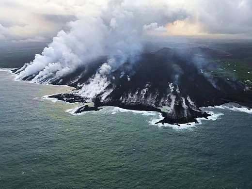
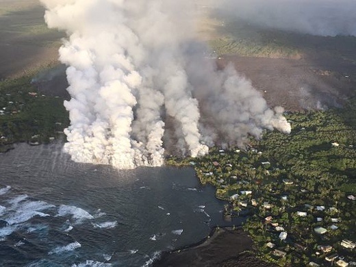
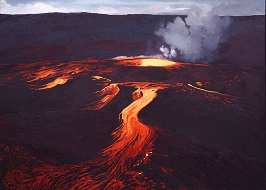
Image above: Photo from south of Puna as Kilauea volcano lava enters Pacific Ocean causing clouds of steam and vog. From (https://www.inverse.com/article/46466-kilauea-volcano-ocean-entry-deemed-hazardous-as-dangerous-laze-persists).
[IB Publisher's note: There is a wide range of opinions about the danger imposed by current volcanic activity on the Big Island of Hawaii. Some fear the risks are being minimized to keep people calm and not scare tourists away. Some even fear a catastrophe of biblical proportions is imminent. Below are recent reports by the United States Geological Survey. They may be hiding the truth to allay a panic. But they, more than any other source, have the real data. Here are some of their recent reports to the public.]
Answers to Questions about Kīlauea Volcano's earthquakes
June 28, 2018
The summit area of Kīlauea Volcano has undergone significant changes since April 2018. On April 21, the lava lake within Halema‘uma‘u overflowed onto the crater floor as the volcano's magmatic system pressurized.
On April 30, the floor of the Pu‘u ‘Ō‘ō crater collapsed, as subsurface pressure forced open a pathway for magma to travel from Pu‘u ‘Ō‘ō into the lower East Rift Zone. As magma moved into the lower East Rift Zone, pressure decreased in the summit's magmatic system and the lava lake level began to drop. The summit also started to deflate due to the pressure decrease.
As summit deflation (or subsidence) persisted, the number of earthquakes increased. Prior to the onset of deflation, about 10 earthquakes per day were typical at the summit. As of late June 2018, there are about 600 earthquakes located in the same region on a daily basis. Many of these earthquakes are strong enough to be felt, and some can be damaging.
These earthquakes are understandably causing concern, especially in Volcano Village and surrounding subdivisions. These Frequently Asked Questions about Kīlauea Volcano's Summit Earthquakes will help answer some of the most commonly asked questions about the nature of Kīlauea's summit activity, and the numerous earthquakes that are occurring in the area.
Saying "goodbye" to one GPS station and "hello" to two more
June 25, 2018
On June 18, Hawaiian Volcano Observatory staff said a sad goodbye to a GPS instrument that had faithfully recorded over 95 m (310 ft) of downward motion of the floor of Kīlauea caldera before losing radio contact. The GPS instrument, called NPIT, first started moving downward in early May at the onset of subsidence at Kīlauea's summit.
However on June 8, NPIT's motion picked up dramatically. This was when a portion of the caldera floor north of Halema'uma'u, where NPIT was located, began to slump into the crater. Over the next ten days NPIT GPS recorded down-dropping of 6-8 m (20-25 ft) with each summit explosion event, which have been occurring almost every day.
This, together with earlier displacements, added up to a position change of 95 m down, 55 m south, and 5 m east (310 ft, 180 ft, and 16 ft, respectively).
These data provide unique insight into the crater collapse process, showing us that it is occurring as a series of steps instead of as continuous motion. Drone and helicopter views confirm that NPIT is still intact and likely still recording data.
Unfortunately, the large motions have now resulted in a misalignment of the radio shot between the instrument and the observatory, cutting off communication and therefore data flow from the GPS station.
At about the same time that we lost the ability to contact NPIT, HVO staff completed work to add telemetry to two temporary GPS stations on the caldera floor.
These two stations, called CALS and VO46, are not located on actively slumping portions of the caldera floor and therefore do not show the dramatic downward motion that NPIT did.
However, they reveal that even portions of the caldera floor away from active slumping are moving downward very quickly; by as much as 1.0 m per day (3.3 feet per day) at station CALS. The data from these new stations can be viewed on the deformation page for Kīlauea.
Why so many earthquakes in the Kīlauea summit area?
May 29, 2018
Deflation at Kīlauea's summit has caused up to 1.5 meters (about 5 feet) of subsidence, which has stressed the faults around and within Kīlauea Caldera. Read more
GPS monitoring reveal where magma has moved
May 24, 2018
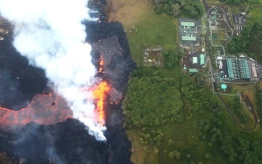
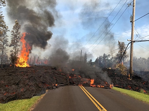
Kīlauea Volcano is currently erupting at two locations: from Halema‘uma‘u, a crater within the summit caldera, and from the lower East Rift Zone (LERZ) in and near the Leilani Estates and Lanipuna subdivisions.
Small explosive episodes at Kīlauea's summit are a consequence of magma withdrawing from a shallow reservoir beneath the east margin of Halema‘uma‘u. The eruption of lava along the LERZ resulted from the underground movement of magma eastward from the volcano's middle East Rift Zone.
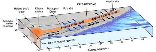
Image above: Illustration of Kīlauea Volcano from the summit caldera to the lower East Rift Zone (LERZ). Blue arrows = contraction across the upper and middle rift zone, black arrows = expansion in LERZ. From original article.
GPS, tiltmeters, and satellite radar (InSAR) data captured how Kīlauea's surface has moved since the Pu‘u ‘Ō‘ō vent collapsed on April 30, 2018. These data allow scientists to infer where magma was removed and the location to which it was transferred. In the first days following the collapse of Pu‘u ‘Ō‘ō, the largest signals indicated contraction across the upper and middle East Rift Zone—evidence that magma was being withdrawn from this area.
This was followed by expansion across the LERZ—evidence that magma was intruding into this part of the rift zone at depths of less than about 3 km (2 mi). The forceful widening of the LERZ continued through May 18, at which time a GPS site north of the intrusion stopped moving northwestward and stabilized.
In early May, days after the collapse of Pu‘u ‘Ō‘ō, the lava lake level in Halema‘uma‘u began to drop as the summit area subsided at a high rate. The lava lake surface disappeared from view on about May 10, at a depth of more than 325 m (1,070 ft) below the Halema‘uma‘u crater floor.
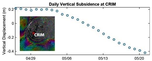
Image above: This plot shows vertical displacement of a USGS GPS (CRIM) station from April 26 to May 24, 2018. From original article.
Subsidence of the summit area continues. Between May 1 and May 24 the caldera floor subsided as much as 1.4 m (4.5 ft). The GPS station, labeled as CRIM on the edge of Kīlauea's summit caldera [Fig.2], has subsided about 0.6 m (1.9 ft).
Continued summit subsidence indicates that magma is moving from the summit magma reservoir and into the East Rift Zone at a higher rate than magma is entering the reservoir from below. To date, geochemical analysis of erupted lava indicates that summit magma has not yet erupted from the LERZ fissures 1-23.
Facts on stability of Kīlauea's south flank, past and present
May 14, 2018
There have been several recent highly speculative stories, rumors and blogs about the stability of the south flank of Kīlauea and the potential for a catastrophic collapse that could generate a Pacific-wide tsunami. We wish to put these speculations in their proper context by presenting observations of the current situation and an assessment of past evidence of landslides from Kīlauea.
There is no geologic evidence for past catastrophic collapses of Kīlauea Volcano that would lead to a major Pacific tsunami, and such an event is extremely unlikely in the future based on monitoring of surface deformation. Kīlauea tends to "slump", which is a slower type of movement that is not associated with tsunamis, although localized tsunamis only affecting the island have been generated by strong earthquakes in the past.
The May 4 M6.9 earthquake resulted in seaward motion of approximately 0.5 m (1.5 ft) along portions of Kīlauea's south flank as measured by GPS stations across the volcano.
A preliminary model suggests that the motion was caused by up to 2.5 meters (8 feet) of slip along the fault that underlies the volcano's south flank, at the interface between the volcano and the ocean floor, about 7-9 km (4-6 mi) beneath the surface.
This motion is within the expected range for a large earthquake on this fault. The earthquake was probably caused by pressure exerted by the magmatic intrusion on the south flank fault, following the pattern of past earthquake activity that has been observed during Kīlauea East Rift Zone intrusions.
A small, very localized tsunami did occur as a result of the fault slip. Similar local tsunamis were generated by past large earthquakes, including the 1975 M7.7 and 1868 ~M8 events, both of which resulted in multiple deaths along the south coast of the Island of Hawai‘i.
Adjustments on the south flank caused another ~9 cm (3.5 inches) of motion at the surface in the day after the earthquake, followed by another 2-3 cm (~1 inch) since May 5.
This is higher than the normal rate of south flank motion (~8 cm (3 inches) per year) but is expected as the volcano adjusts after a combination of a magmatic intrusion along the East Rift Zone and a large south flank earthquake.
We did observe minor ground ruptures on the south flank, but this is expected given the strength of the May 4 earthquake, and deformation data show that the south flank continues to move as an intact slump block.
Geologic history combined with models of south flank motion suggest that the likelihood of a catastrophic failure event is incredibly remote. There are certainly signs on the ocean floor for landslides from other volcanoes on the Island of Hawai‘i and from other islands, but none are associated with Kīlauea.
In addition, Kīlauea has experienced much larger earthquakes and magmatic intrusions in the recent past. The large earthquakes of 1975 and 1868 were not associated with significant south flank landsliding, nor were major East Rift Zone intrusions in 1840 and 1924.

Image above: This plot shows vertical displacement of a USGS GPS (CRIM) station from April 26 to May 24, 2018. Cross-section through the lower East Rift Zone of Kīlauea Volcano. From original article.
Cross-section through the lower East Rift Zone of Kīlauea Volcano. Magma intruded into the rift zone and exerted pressure on the south flank of Kīlauea, likely encouraging the M6.9 earthquake that occurred on a fault located at the interface between the volcano and the preexisting ocean floor.
.
By Staff on 28 June 2018 for United States Geological Survey -
(https://volcanoes.usgs.gov/observatories/hvo/)
Image above: Photo from south of Puna as Kilauea volcano lava enters Pacific Ocean causing clouds of steam and vog. From (https://www.inverse.com/article/46466-kilauea-volcano-ocean-entry-deemed-hazardous-as-dangerous-laze-persists).
[IB Publisher's note: There is a wide range of opinions about the danger imposed by current volcanic activity on the Big Island of Hawaii. Some fear the risks are being minimized to keep people calm and not scare tourists away. Some even fear a catastrophe of biblical proportions is imminent. Below are recent reports by the United States Geological Survey. They may be hiding the truth to allay a panic. But they, more than any other source, have the real data. Here are some of their recent reports to the public.]
Answers to Questions about Kīlauea Volcano's earthquakes
June 28, 2018
The summit area of Kīlauea Volcano has undergone significant changes since April 2018. On April 21, the lava lake within Halema‘uma‘u overflowed onto the crater floor as the volcano's magmatic system pressurized.
On April 30, the floor of the Pu‘u ‘Ō‘ō crater collapsed, as subsurface pressure forced open a pathway for magma to travel from Pu‘u ‘Ō‘ō into the lower East Rift Zone. As magma moved into the lower East Rift Zone, pressure decreased in the summit's magmatic system and the lava lake level began to drop. The summit also started to deflate due to the pressure decrease.
As summit deflation (or subsidence) persisted, the number of earthquakes increased. Prior to the onset of deflation, about 10 earthquakes per day were typical at the summit. As of late June 2018, there are about 600 earthquakes located in the same region on a daily basis. Many of these earthquakes are strong enough to be felt, and some can be damaging.
These earthquakes are understandably causing concern, especially in Volcano Village and surrounding subdivisions. These Frequently Asked Questions about Kīlauea Volcano's Summit Earthquakes will help answer some of the most commonly asked questions about the nature of Kīlauea's summit activity, and the numerous earthquakes that are occurring in the area.
Saying "goodbye" to one GPS station and "hello" to two more
June 25, 2018
On June 18, Hawaiian Volcano Observatory staff said a sad goodbye to a GPS instrument that had faithfully recorded over 95 m (310 ft) of downward motion of the floor of Kīlauea caldera before losing radio contact. The GPS instrument, called NPIT, first started moving downward in early May at the onset of subsidence at Kīlauea's summit.
However on June 8, NPIT's motion picked up dramatically. This was when a portion of the caldera floor north of Halema'uma'u, where NPIT was located, began to slump into the crater. Over the next ten days NPIT GPS recorded down-dropping of 6-8 m (20-25 ft) with each summit explosion event, which have been occurring almost every day.
This, together with earlier displacements, added up to a position change of 95 m down, 55 m south, and 5 m east (310 ft, 180 ft, and 16 ft, respectively).
These data provide unique insight into the crater collapse process, showing us that it is occurring as a series of steps instead of as continuous motion. Drone and helicopter views confirm that NPIT is still intact and likely still recording data.
Unfortunately, the large motions have now resulted in a misalignment of the radio shot between the instrument and the observatory, cutting off communication and therefore data flow from the GPS station.
At about the same time that we lost the ability to contact NPIT, HVO staff completed work to add telemetry to two temporary GPS stations on the caldera floor.
These two stations, called CALS and VO46, are not located on actively slumping portions of the caldera floor and therefore do not show the dramatic downward motion that NPIT did.
However, they reveal that even portions of the caldera floor away from active slumping are moving downward very quickly; by as much as 1.0 m per day (3.3 feet per day) at station CALS. The data from these new stations can be viewed on the deformation page for Kīlauea.
Why so many earthquakes in the Kīlauea summit area?
May 29, 2018
Deflation at Kīlauea's summit has caused up to 1.5 meters (about 5 feet) of subsidence, which has stressed the faults around and within Kīlauea Caldera. Read more
GPS monitoring reveal where magma has moved
May 24, 2018
Kīlauea Volcano is currently erupting at two locations: from Halema‘uma‘u, a crater within the summit caldera, and from the lower East Rift Zone (LERZ) in and near the Leilani Estates and Lanipuna subdivisions.
Small explosive episodes at Kīlauea's summit are a consequence of magma withdrawing from a shallow reservoir beneath the east margin of Halema‘uma‘u. The eruption of lava along the LERZ resulted from the underground movement of magma eastward from the volcano's middle East Rift Zone.
Image above: Illustration of Kīlauea Volcano from the summit caldera to the lower East Rift Zone (LERZ). Blue arrows = contraction across the upper and middle rift zone, black arrows = expansion in LERZ. From original article.
GPS, tiltmeters, and satellite radar (InSAR) data captured how Kīlauea's surface has moved since the Pu‘u ‘Ō‘ō vent collapsed on April 30, 2018. These data allow scientists to infer where magma was removed and the location to which it was transferred. In the first days following the collapse of Pu‘u ‘Ō‘ō, the largest signals indicated contraction across the upper and middle East Rift Zone—evidence that magma was being withdrawn from this area.
This was followed by expansion across the LERZ—evidence that magma was intruding into this part of the rift zone at depths of less than about 3 km (2 mi). The forceful widening of the LERZ continued through May 18, at which time a GPS site north of the intrusion stopped moving northwestward and stabilized.
In early May, days after the collapse of Pu‘u ‘Ō‘ō, the lava lake level in Halema‘uma‘u began to drop as the summit area subsided at a high rate. The lava lake surface disappeared from view on about May 10, at a depth of more than 325 m (1,070 ft) below the Halema‘uma‘u crater floor.
Image above: This plot shows vertical displacement of a USGS GPS (CRIM) station from April 26 to May 24, 2018. From original article.
Subsidence of the summit area continues. Between May 1 and May 24 the caldera floor subsided as much as 1.4 m (4.5 ft). The GPS station, labeled as CRIM on the edge of Kīlauea's summit caldera [Fig.2], has subsided about 0.6 m (1.9 ft).
Continued summit subsidence indicates that magma is moving from the summit magma reservoir and into the East Rift Zone at a higher rate than magma is entering the reservoir from below. To date, geochemical analysis of erupted lava indicates that summit magma has not yet erupted from the LERZ fissures 1-23.
Facts on stability of Kīlauea's south flank, past and present
May 14, 2018
There have been several recent highly speculative stories, rumors and blogs about the stability of the south flank of Kīlauea and the potential for a catastrophic collapse that could generate a Pacific-wide tsunami. We wish to put these speculations in their proper context by presenting observations of the current situation and an assessment of past evidence of landslides from Kīlauea.
There is no geologic evidence for past catastrophic collapses of Kīlauea Volcano that would lead to a major Pacific tsunami, and such an event is extremely unlikely in the future based on monitoring of surface deformation. Kīlauea tends to "slump", which is a slower type of movement that is not associated with tsunamis, although localized tsunamis only affecting the island have been generated by strong earthquakes in the past.
The May 4 M6.9 earthquake resulted in seaward motion of approximately 0.5 m (1.5 ft) along portions of Kīlauea's south flank as measured by GPS stations across the volcano.
A preliminary model suggests that the motion was caused by up to 2.5 meters (8 feet) of slip along the fault that underlies the volcano's south flank, at the interface between the volcano and the ocean floor, about 7-9 km (4-6 mi) beneath the surface.
This motion is within the expected range for a large earthquake on this fault. The earthquake was probably caused by pressure exerted by the magmatic intrusion on the south flank fault, following the pattern of past earthquake activity that has been observed during Kīlauea East Rift Zone intrusions.
A small, very localized tsunami did occur as a result of the fault slip. Similar local tsunamis were generated by past large earthquakes, including the 1975 M7.7 and 1868 ~M8 events, both of which resulted in multiple deaths along the south coast of the Island of Hawai‘i.
Adjustments on the south flank caused another ~9 cm (3.5 inches) of motion at the surface in the day after the earthquake, followed by another 2-3 cm (~1 inch) since May 5.
This is higher than the normal rate of south flank motion (~8 cm (3 inches) per year) but is expected as the volcano adjusts after a combination of a magmatic intrusion along the East Rift Zone and a large south flank earthquake.
We did observe minor ground ruptures on the south flank, but this is expected given the strength of the May 4 earthquake, and deformation data show that the south flank continues to move as an intact slump block.
Geologic history combined with models of south flank motion suggest that the likelihood of a catastrophic failure event is incredibly remote. There are certainly signs on the ocean floor for landslides from other volcanoes on the Island of Hawai‘i and from other islands, but none are associated with Kīlauea.
In addition, Kīlauea has experienced much larger earthquakes and magmatic intrusions in the recent past. The large earthquakes of 1975 and 1868 were not associated with significant south flank landsliding, nor were major East Rift Zone intrusions in 1840 and 1924.
Image above: This plot shows vertical displacement of a USGS GPS (CRIM) station from April 26 to May 24, 2018. Cross-section through the lower East Rift Zone of Kīlauea Volcano. From original article.
Cross-section through the lower East Rift Zone of Kīlauea Volcano. Magma intruded into the rift zone and exerted pressure on the south flank of Kīlauea, likely encouraging the M6.9 earthquake that occurred on a fault located at the interface between the volcano and the preexisting ocean floor.
.