SUBHEAD: The Army Corp changed the route of the DAPL to cross sovereign Sioux territory. A serious mistake.
By NoDAPL Map on 1 November 2016 for Northlandia -
(https://northlandia.wordpress.com/2016/11/01/a-nodapl-map/)
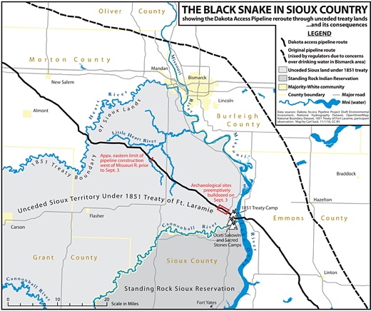
Image above: Map comparing the original DAPL route passing north of Bismark ND approved by the Army Corps of Engineers (dotted black line) that did not pass through unceded Sioux territory and modified route (solid black) that was chosen after complaints by residents of Bismark. From original article. Click to save enlarged tiff format map. Note tiff file is highly detailed.
By NoDAPL Map on 1 November 2016 for Northlandia -
(https://northlandia.wordpress.com/2016/11/01/a-nodapl-map/)
Image above: Map comparing the original DAPL route passing north of Bismark ND approved by the Army Corps of Engineers (dotted black line) that did not pass through unceded Sioux territory and modified route (solid black) that was chosen after complaints by residents of Bismark. From original article. Click to save enlarged tiff format map. Note tiff file is highly detailed.
When I decided to become a cartographer, I didn’t just want to make pretty and useful maps. I became a cartographer to make maps that change the world for the better. Right now, no situation needs this kind of map more than the current drama unfolding around the Dakota Access Oil Pipeline’s crossing of the Missouri River.
Thousands of Native Americans and their allies have gathered on unceded Sioux land delimited by the 1851 Treaty of Fort Laramie to try and stand in the way of the “black snake” that could poison the Standing Rock Reservation’s water supply.
Many have noted that the pipeline corridor was repositioned from its original route north of Bismarck after white citizens spoke up against the threat a spill would pose to their drinking water ― a threat duly recognized by the U.S. Army Corps of Engineers. Yet the Corps failed its federal mandate for meaningful consultation with the Standing Rock Tribe before signing off on a route that moved the pipeline to their doorstep.
This is not to say that the good citizens of Bismarck and Mandan were wrong to protest. What’s wrong with the picture above isn’t the routing of the pipeline. What’s wrong is that the pipeline project exists to begin with. Some say it’s a good alternative to dangerous oil-by-rail shipments of Bakken crude. Those are bad too.
We don’t need more fossil fuels making it to market to be burned and burn up the planet in turn (I am typing this in Wisconsin as the temperature nears 70 on the first of November). We do all need clean water. As the Sioux say, mni wiconi (”water is life”).
To keep to its construction schedule, the pipeline company, Energy Transfer Partners, has met nonviolent water protectors with private security guards using attack dogs in a scene reminiscent of 1963 Birmingham.
It has worked hand-in-glove with law enforcement and the National Guard to create a militarized response straight out of apartheid South Africa or occupied Ireland. It has locked up hundreds of protesters in wire cages like those used early on at Guantanamo Bay.
Those on the ground fear something like another Kent State, yet they keep coming, and the worldwide solidarity has gone viral.
Yet for all that, when I went out to camp with the water protectors at Oceti Sakowin on October 13, I had to rely on a friend’s hand-drawn sketch posted to Facebook for directions to the camp.
If you Google “NoDAPL map,” you’ll find few maps available to provide visual context for the unfolding drama.
The most popular seems to be the company’s own very-small-scale route map, showing a dotted line over highlighted counties on a generic road map backdrop.

Image above: Map from the pipeline company showing entire route of pipeline from shale oil sources to Illinois terminus. From original article.
See also:
Ea O Ka Aina: Obama hints at DAPL rerouting 11/3/16
Ea O Ka Aina: New military attack on NODAPL 11/3/16
Ea O Ka Aina: How to Support NoDAPL 11/3/16
Unicorn Riot Tweets NoDAPL 11/2/16
Ea O Ka Aina: Standing Rock & the Ballot Box 10/31/16
Ea O Ka Aina: NoDAPL reclaim new frontline 10/24/16
Ea O Ka Aina: How far will North Dakota go? 10/23/16
Ea O Ka Aina: Amy Goodman "riot" charge dropped 10/17/16
Ea O Ka Aina: Amy Goodwin to face "Riot Charge" 10/16/16
Ea O Ka Aina: Shutdown of all tar sand pipelines 10/11/16
Ea O Ka Aina: Why Standing Rock is test for Oabama 10/8/16
Ea O Ka Aina: Why we are Singing for Water 10/8/16
Ea O Ka Aina: Labor's Dakota Access Pipeline Crisis 10/3/16
Ea O Ka Aina: Standing Firm for Standing Rock 10/3/16
Ea O Ka Aina: Contact bankers behind DAPL 9/29/16
Ea O Ka Aina: NoDAPL demo at Enbridge Inc 9/29/16
Ea O Ka Aina: Militarized Police raid NoDAPL 9/28/16
Ea O Ka Aina: Stop funding of Dakota Access Pipeline 9/27/16
Ea O Ka Aina: UN experts to US, "Stop DAPL Now!" 9/27/16
Ea O Ka Aina: No DAPL solidarity grows 9/21/16
Ea O Ka Aina: This is how we should be living 9/16/16
Ea O Ka Aina: 'Natural Capital' replacing 'Nature' 9/14/16
Ea O Ka Aina: The Big Difference at Standing Rock 9/13/16
Ea O Ka Aina: Jill Stein joins Standing Rock Sioux 9/10/16
Ea O Ka Aina: Pipeline temporarily halted 9/6/16
Ea O Ka Aina: Native Americans attacked with dogs 9/5/16
Ea O Ka Aina: Mni Wiconi! Water is Life! 9/3/16
Ea O Ka Aina: Sioux can stop the Pipeline 8/28/16
Ea O Ka Aina: Officials cut water to Sioux 8/23/16
.Thousands of Native Americans and their allies have gathered on unceded Sioux land delimited by the 1851 Treaty of Fort Laramie to try and stand in the way of the “black snake” that could poison the Standing Rock Reservation’s water supply.
Many have noted that the pipeline corridor was repositioned from its original route north of Bismarck after white citizens spoke up against the threat a spill would pose to their drinking water ― a threat duly recognized by the U.S. Army Corps of Engineers. Yet the Corps failed its federal mandate for meaningful consultation with the Standing Rock Tribe before signing off on a route that moved the pipeline to their doorstep.
This is not to say that the good citizens of Bismarck and Mandan were wrong to protest. What’s wrong with the picture above isn’t the routing of the pipeline. What’s wrong is that the pipeline project exists to begin with. Some say it’s a good alternative to dangerous oil-by-rail shipments of Bakken crude. Those are bad too.
We don’t need more fossil fuels making it to market to be burned and burn up the planet in turn (I am typing this in Wisconsin as the temperature nears 70 on the first of November). We do all need clean water. As the Sioux say, mni wiconi (”water is life”).
To keep to its construction schedule, the pipeline company, Energy Transfer Partners, has met nonviolent water protectors with private security guards using attack dogs in a scene reminiscent of 1963 Birmingham.
It has worked hand-in-glove with law enforcement and the National Guard to create a militarized response straight out of apartheid South Africa or occupied Ireland. It has locked up hundreds of protesters in wire cages like those used early on at Guantanamo Bay.
Those on the ground fear something like another Kent State, yet they keep coming, and the worldwide solidarity has gone viral.
Yet for all that, when I went out to camp with the water protectors at Oceti Sakowin on October 13, I had to rely on a friend’s hand-drawn sketch posted to Facebook for directions to the camp.
If you Google “NoDAPL map,” you’ll find few maps available to provide visual context for the unfolding drama.
The most popular seems to be the company’s own very-small-scale route map, showing a dotted line over highlighted counties on a generic road map backdrop.
Image above: Map from the pipeline company showing entire route of pipeline from shale oil sources to Illinois terminus. From original article.
This kind of view erases the people affected by the pipeline – quite literally, by covering over their communities with a hot pink gradient fill. It doesn’t tell you that all of Turtle Island (North America) is Indian Country, or that the project runs headlong into international treaties signed between the U.S. and various tribes and then unilaterally violated by Congress.
It doesn’t show you where the frontline communities have set up camp to fight back (and here I realize that I should also make a map of the Bold Iowa resistance camp), or where the pipeline company, spurred on by the internal pressure of their $3.8 billion investment, has bulldozed sacred ground, or where exactly a pipeline break would endanger the drinking water of millions downstream.
There was one other better map of the project that I found and was partially inspired by ― a relatively simple yet powerful map by Jordan Engle (with help from Dakota Wind) published by The Decolonial Atlas.
It uses the indigenous placenames for key waterways and sites in the vicinity of the Sacred Stones Camp (translations are on the blog post linked to above). It is oriented to the south, challenging the typical viewpoint of Western maps. This map has truly not gotten the attention it deserves.

Image above: Dakota Access Pipeline Indigenous Protest Map by Jordan Engle and Dakota Wind, The Decolonial Atlas. From original article.
Maps like this are great, and there should be more of them. However, I felt strongly that there still needed to be a map of the area that would look familiar to most viewers and orient them to the important geographic facts of the struggle.
I don’t claim that none of those facts are currently in dispute, but I recognize that all maps (even road maps overlaid with pink polygons) take a position and create knowledge based on the cartographer’s point of view. Maps have great power, and it’s a power anyone with pen and paper or a computer can wield.
My geographer hero Zoltan Grossman once declared, “The side with the best maps wins.” The pipeline company has an army backed by state power to do its bidding. The water has its scrappy protectors. It’s time we put the latter on the map.
It doesn’t show you where the frontline communities have set up camp to fight back (and here I realize that I should also make a map of the Bold Iowa resistance camp), or where the pipeline company, spurred on by the internal pressure of their $3.8 billion investment, has bulldozed sacred ground, or where exactly a pipeline break would endanger the drinking water of millions downstream.
There was one other better map of the project that I found and was partially inspired by ― a relatively simple yet powerful map by Jordan Engle (with help from Dakota Wind) published by The Decolonial Atlas.
It uses the indigenous placenames for key waterways and sites in the vicinity of the Sacred Stones Camp (translations are on the blog post linked to above). It is oriented to the south, challenging the typical viewpoint of Western maps. This map has truly not gotten the attention it deserves.
Image above: Dakota Access Pipeline Indigenous Protest Map by Jordan Engle and Dakota Wind, The Decolonial Atlas. From original article.
Maps like this are great, and there should be more of them. However, I felt strongly that there still needed to be a map of the area that would look familiar to most viewers and orient them to the important geographic facts of the struggle.
I don’t claim that none of those facts are currently in dispute, but I recognize that all maps (even road maps overlaid with pink polygons) take a position and create knowledge based on the cartographer’s point of view. Maps have great power, and it’s a power anyone with pen and paper or a computer can wield.
My geographer hero Zoltan Grossman once declared, “The side with the best maps wins.” The pipeline company has an army backed by state power to do its bidding. The water has its scrappy protectors. It’s time we put the latter on the map.
See also:
Ea O Ka Aina: Obama hints at DAPL rerouting 11/3/16
Ea O Ka Aina: New military attack on NODAPL 11/3/16
Ea O Ka Aina: How to Support NoDAPL 11/3/16
Unicorn Riot Tweets NoDAPL 11/2/16
Ea O Ka Aina: Standing Rock & the Ballot Box 10/31/16
Ea O Ka Aina: NoDAPL reclaim new frontline 10/24/16
Ea O Ka Aina: How far will North Dakota go? 10/23/16
Ea O Ka Aina: Amy Goodman "riot" charge dropped 10/17/16
Ea O Ka Aina: Amy Goodwin to face "Riot Charge" 10/16/16
Ea O Ka Aina: Shutdown of all tar sand pipelines 10/11/16
Ea O Ka Aina: Why Standing Rock is test for Oabama 10/8/16
Ea O Ka Aina: Why we are Singing for Water 10/8/16
Ea O Ka Aina: Labor's Dakota Access Pipeline Crisis 10/3/16
Ea O Ka Aina: Standing Firm for Standing Rock 10/3/16
Ea O Ka Aina: Contact bankers behind DAPL 9/29/16
Ea O Ka Aina: NoDAPL demo at Enbridge Inc 9/29/16
Ea O Ka Aina: Militarized Police raid NoDAPL 9/28/16
Ea O Ka Aina: Stop funding of Dakota Access Pipeline 9/27/16
Ea O Ka Aina: UN experts to US, "Stop DAPL Now!" 9/27/16
Ea O Ka Aina: No DAPL solidarity grows 9/21/16
Ea O Ka Aina: This is how we should be living 9/16/16
Ea O Ka Aina: 'Natural Capital' replacing 'Nature' 9/14/16
Ea O Ka Aina: The Big Difference at Standing Rock 9/13/16
Ea O Ka Aina: Jill Stein joins Standing Rock Sioux 9/10/16
Ea O Ka Aina: Pipeline temporarily halted 9/6/16
Ea O Ka Aina: Native Americans attacked with dogs 9/5/16
Ea O Ka Aina: Mni Wiconi! Water is Life! 9/3/16
Ea O Ka Aina: Sioux can stop the Pipeline 8/28/16
Ea O Ka Aina: Officials cut water to Sioux 8/23/16
No comments :
Post a Comment