SUBHEAD: The Wailua-Kapaa Neighborhood Assoc meeting with guest speaker Juan Wilson, present "From Mokupuni to Ahupuaa".
By Rayne Raygush on 6 January for W-K Neighborhood Assoc.
(http://islandbreath.blogspot.com/2015/01/from-mokupuni-to-ahupuaa.html)
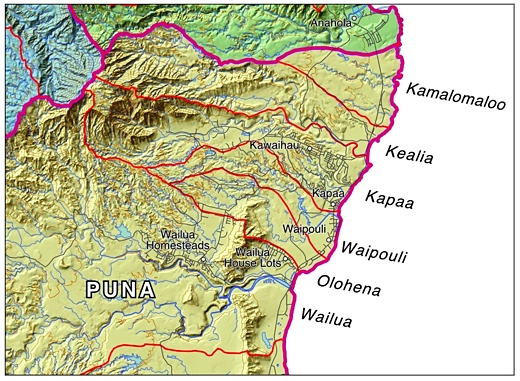
Image above: The Wailua-Kapaa Neighborhood Association is in the north part of the Puna Moku of Kauai between the North Fork of the Wailua River and south of Kealia Stream. Cartography by Juan Wilson. Derived from (http://www.islandbreath.org/mokupuni/mokupuni.html). Click to embiggen.
WHAT:
Wailua-Kapaa Neighborhood Association meeting will feature guest speaker Juan Wilson, presenting “From Mokupuni to Ahupuaa”By Rayne Raygush on 6 January for W-K Neighborhood Assoc.
(http://islandbreath.blogspot.com/2015/01/from-mokupuni-to-ahupuaa.html)

Image above: The Wailua-Kapaa Neighborhood Association is in the north part of the Puna Moku of Kauai between the North Fork of the Wailua River and south of Kealia Stream. Cartography by Juan Wilson. Derived from (http://www.islandbreath.org/mokupuni/mokupuni.html). Click to embiggen.
WHAT:
WHEN:
Saturday, January 24th, 2015 at 2:00pm until 4:00pm
WHERE:
Kapaa Public Library Meeting Room
INFO:
The presentation is free and open to the public.
CONTACT:
Sid Jackson, W-K Neighborhood Association Secretary
Phone: (808) 821-2837
Email: sjackson23@hawaii.rr.com
The Wailua-Kapaa Neighborhood Association will feature guest speaker Juan Wilson, presenting “From Mokupuni to Ahupuaa” on Saturday, January 24, 2014, 2:00 p.m. at the Kapaa Library Meeting Room. The presentation is free and open to the public.
The traditional land divisions of pre-contact Hawaiians were based on the sustainability and self- reliance within community watershed areas (ahupua`a) as well as within bioregions (moku) and lastly individual sovereign islands (mokupuni). These natural land divisions were the result of the flow of water over the land.
In 2010, Wilson, an architect and planner, conducted a detailed survey using historical documents, early Hawaiian Maps, USGS survey maps, the support of the Statewide Aha Keole Advisory Committee, The Western Pacific Regional Fishery Council, the Kauai Historic Society, and individual accounts from residents such Ileialoha Beniamina.
Applied to these sources, Wilson, with assistance from designer Jonathan Jay, used the geography of the islands based on 3D GoogleEarth elevations and USGS map data, as well as the State of Hawai`i GIS data on watersheds, streams and topographical contours. This information was used to tie the traditional information to modern geographic modeling which describes the flow of water over the land.
Historically, boundaries were also determined by the political influence and power. However, to the degree possible, land divisions based on conquest and private ownership were ignored, and this mapping project kept to the relation of Hawaiians to the `aina itself.
“We hope this information will foster more cultural awareness, and a greater understanding and use of native Hawaiian resource knowledge”, says Rayne Regush - Wailua-Kapaa Neighborhood Association.
The meeting will also include updates on other local issues. For more information, contact Association Secretary Sid Jackson at 821-2837 or visit www.wkna.org.
“Opportunities that reinforce our connection to the land and natural resources also help to preserve Hawaiian cultural heritage and traditional values.”
Serving Residents of the Kawaihau District
“We treasure our rural community”
340 Aina Uka Street, Kapaa, Hawaii 96746
.
No comments :
Post a Comment