SUBHEAD: In 2009 the DLNR had already determined the fenced in area to be in the CD when they cited Laymon.
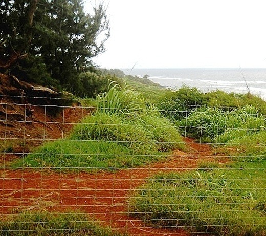 Image above: Fence illegally blocking public access to Lepeuli Beach. Photo from Hawaii Sierra Club.
For a moment it looked like the story of the new apparently illegal fence at Lepeuli (Larsen’s) Beach had hit the big time.
After seeing the headline and subhead in this morning's Honolulu paper stating that "Development blocks traditional access; Landowners on three isles prevent people from using trails crossing their land" and seeing the story began with the name of Linda Sproat- one of those who has been most aggrieved and active in preserving the Alaloa that is now blocked by the fence- what else could it be?
But although the article is an all too familiar story of Kaua`i Planning Department bungling in preserving an access to Kauapea (Secret) Beach, nothing on the blocking of the ancient traditional access by Paradise Ranch's Bruce Laymon.
And there's nothing new on our story of Jesse Reynolds' allegation that Laymon tried to kill him last month although County Public Information Officer Mary Daubert says that "(a)ccording to KPD, the case is under investigation pending further developments, therefore, we cannot comment."
But there is news from Hope Kallai of Malama Moloa`a who has filed a complaint with the Land Use Commission asking how the heck they can ignore the fence which was apparently constructed in a conservation district (CD) without a conservation district use permit (CDUP) after Laymon withdrew his permit when the Department of Land and Natural Resources (DLNR) decided to take a second look at it.
Kallai presents documentation noting that in 2009 the DLNR had already determined the fenced in area to be in the CD when they cited Laymon for unpermitted work and essentially asks for action.
She then presents the whole sordid history of Laymon's action in the area - a story which deserves a concise presentation.
Which is why today we present her letter in full.
Image above: Fence illegally blocking public access to Lepeuli Beach. Photo from Hawaii Sierra Club.
For a moment it looked like the story of the new apparently illegal fence at Lepeuli (Larsen’s) Beach had hit the big time.
After seeing the headline and subhead in this morning's Honolulu paper stating that "Development blocks traditional access; Landowners on three isles prevent people from using trails crossing their land" and seeing the story began with the name of Linda Sproat- one of those who has been most aggrieved and active in preserving the Alaloa that is now blocked by the fence- what else could it be?
But although the article is an all too familiar story of Kaua`i Planning Department bungling in preserving an access to Kauapea (Secret) Beach, nothing on the blocking of the ancient traditional access by Paradise Ranch's Bruce Laymon.
And there's nothing new on our story of Jesse Reynolds' allegation that Laymon tried to kill him last month although County Public Information Officer Mary Daubert says that "(a)ccording to KPD, the case is under investigation pending further developments, therefore, we cannot comment."
But there is news from Hope Kallai of Malama Moloa`a who has filed a complaint with the Land Use Commission asking how the heck they can ignore the fence which was apparently constructed in a conservation district (CD) without a conservation district use permit (CDUP) after Laymon withdrew his permit when the Department of Land and Natural Resources (DLNR) decided to take a second look at it.
Kallai presents documentation noting that in 2009 the DLNR had already determined the fenced in area to be in the CD when they cited Laymon for unpermitted work and essentially asks for action.
She then presents the whole sordid history of Laymon's action in the area - a story which deserves a concise presentation.
Which is why today we present her letter in full.
1 June 2011
Fred Talon Land Use Commission Department of Business, Economic Development & Tourism State of Hawaii P.O. Box 2359 Honolulu, Hawaii 96804-2359 (808) 587-3822 Fax: (808) 587-3827 Re: Prioritization of Conservation District Boundary Interpretation Request TMK (4) 5-1-3:003 Waioli Corporation (owner), Paradise Ranch (lessee) Lepeuli, Kauai,
Aloha e Mr. Talon: I would like to request prioritization of the Conservation District Boundary Interpretation on Waioli Corporation lands in Lepeuli, Kauai, that we previously spoke about on the phone (Feb., 2011 and April 2011). This request was also made by the Kauai Chapter of the Sierra Club (attached Feb. 10, 2011 letter). I understand that your office is understaffed and that your work load is heavy, but there is a need for this boundary determination interpretation to be expedited. Fencing has been recently constructed by lessee, Paradise Ranch LLC, in what appears to be this Conservation District. May 2011 Fencing in Lepeuli In 2009, Paradise Ranch was cited for performing work in the Conservation District. Paradise Ranch applied for a SMA Minor permit from the county of Kauai for fencing and this fencing map were submitted then. 2009 Lepeuli Map with County Engineer’s notes An After-The-Fact CDUP was applied for work in this Lepeuli Conservation District, CDUP KA-3525, (attached), with fencing proposed at 110‘ from the shoreline. This permit was awarded, appealed by community groups, then later surrendered by the applicant, stating they had decided to move operations out of the Conservation District. After community members requested that stamped surveyors maps be presented as per the County Engineer’s original 2009 request (attached), Paradise Ranch LLC recently presented a stamped map (below) with a proposed fenceline in very close proximity to applicant’s interpretation of the CD location. This map states “minimum distance to be 110’ from shoreline” for the proposed fenceline. 2011 map with fenceline next to CD Boundary (as interpreted by Paradise Ranch) Attached Conservation District maps and articles show the Conservation District to be 300’ from a certified shoreline in this area. A entirely new fence was recently constructed by Paradise Ranch LLC in Lepeuli. We believe this fence is in the Conservation District and blocks the lateral coastal Alaloa. This project is federally funded through NRCS EQIP program. The pasture created by this new makai fence configuration will enable cattle to graze on a site where Hawaii State Department of Historic Preservation relocated human skeletal remains from 3 individuals. This is illegal as well as socially unconscionable. Paradise Ranch has continued to manage the coastal vegetation in the Conservation with heavy equipment, brushhogs and chainsaws. The fenceline has been constructed in the apparent Conservation District, blocking an ancient lateral trail. Steps need to be taken to determine the location of the boundary between the Conservation District and the Agricultural District in Lepeuli, as soon as possible. The Conservation District boundary presented on the maps by Paradise Ranch LLC is erroneous and and the fencing negatively impacts public access, human remains and archaeological sites. This makai Conservation District is a primary monk seal pupping and rearing area. Two pups are being reared at Ka`aka`aniu reef right now. Impacts must be considered to endangered species by the restriction of public access on the ancient Alaloa trail. This forces all lateral transit on to the beach. There are significant impacts to this fencing project. The Conservation District Boundary needs to be interpreted and determined by the state as soon as possible. What can we do to expedite this? Mahalo for your help. Hope Kallai Malama Moloa`a Attachments: Sierra Club Land Use Request SMA-Minor CDUA 3525 2011 map CD maps CD Boundary article Engineers notes .
No comments :
Post a Comment