SOURCE: Elaine Dunbar (inunyabus@gmail.com)
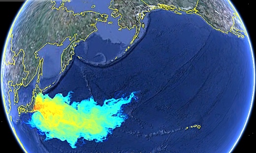
SUBHEAD: Simulation of plume of radioactive seawater from Fukushima between March 11th to Auguat 11th 2011.
By Dutch Sinse on 20 August 2011 for Dutchinse.com -
(http://www.dutchsinse.com/blog/?p=1396)

Image above: 8/11/11 simulation of radioactive seawater dispersed from Fukushima nears Hawaii. From (http://www.xydo.com/toolbar/27327691-asr_ltd_-_fukushima_radioactive_seawater_plume_dispersal_simulation).
Note - The video below is no longer available when tested 1/21/14.
Video above: Radioactive seawater plume simulation from Fukushima. From (http://youtu.be/ZKJRF9GYNSU).
IB Publisher's note: This accompanied simulation - ASR (xydo.com) uses a Lagrangian particles dispersal method to track where free floating material (fish larvae, algae, phytoplankton, zooplankton...) is present in the sea water near the damaged Fukushima Daiichi nuclear power station plant could have gone since the earthquake on March 11th. THIS IS NOT A REPRESENTATION OF THE RADIOACTIVE PLUME CONCENTRATION. Since we do not know how much contaminated water and at what concentration was released into the ocean, it is impossible to estimate the extent and dilution of the plume.
However, field monitoring by TEPCO and modelling by the Sirrocco group in University of Toulouse, France both show high concentration in the surrounding water (highest rate at 80 Bq/L and 24 Bq/L for respectively I-131 and C-137. Assuming that a part of the passive biomass could have been contaminated in the area, we are trying to track where the radionuclides are spreading as it will eventually climb up the food chain.
The dispersal model is ASR's Pol3DD. The model is forced by hydrodynamic data from the HYCOM/NCODA system which provides on a weekly basis, daily oceanic current in the world ocean. The resolution in this part of the Pacific Ocean is around 8km x 8km cells. We are treating only the sea surface currents. Particles in the model are continuously released near the Fukushima Daiichi power plant since March 11th.
The dispersal model keeps a trace of their visits in the model cells. The results here are expressed in number of visit per surface area of material which has been in contact at least once with the highly concentrated radioactive water. .
SUBHEAD: Simulation of plume of radioactive seawater from Fukushima between March 11th to Auguat 11th 2011.
By Dutch Sinse on 20 August 2011 for Dutchinse.com -
(http://www.dutchsinse.com/blog/?p=1396)

Image above: 8/11/11 simulation of radioactive seawater dispersed from Fukushima nears Hawaii. From (http://www.xydo.com/toolbar/27327691-asr_ltd_-_fukushima_radioactive_seawater_plume_dispersal_simulation).
Note - The video below is no longer available when tested 1/21/14.
Video above: Radioactive seawater plume simulation from Fukushima. From (http://youtu.be/ZKJRF9GYNSU).
IB Publisher's note: This accompanied simulation - ASR (xydo.com) uses a Lagrangian particles dispersal method to track where free floating material (fish larvae, algae, phytoplankton, zooplankton...) is present in the sea water near the damaged Fukushima Daiichi nuclear power station plant could have gone since the earthquake on March 11th. THIS IS NOT A REPRESENTATION OF THE RADIOACTIVE PLUME CONCENTRATION. Since we do not know how much contaminated water and at what concentration was released into the ocean, it is impossible to estimate the extent and dilution of the plume.
However, field monitoring by TEPCO and modelling by the Sirrocco group in University of Toulouse, France both show high concentration in the surrounding water (highest rate at 80 Bq/L and 24 Bq/L for respectively I-131 and C-137. Assuming that a part of the passive biomass could have been contaminated in the area, we are trying to track where the radionuclides are spreading as it will eventually climb up the food chain.
The dispersal model is ASR's Pol3DD. The model is forced by hydrodynamic data from the HYCOM/NCODA system which provides on a weekly basis, daily oceanic current in the world ocean. The resolution in this part of the Pacific Ocean is around 8km x 8km cells. We are treating only the sea surface currents. Particles in the model are continuously released near the Fukushima Daiichi power plant since March 11th.
The dispersal model keeps a trace of their visits in the model cells. The results here are expressed in number of visit per surface area of material which has been in contact at least once with the highly concentrated radioactive water. .
4 comments :
I think the model is not too far off from accurate. 6 months and it will be ashore in HI.
Aloha Anonymous,
As a bit of comfort let me point out a couple of things about it. GoogleEarth was only used as a "backgound" for their data.
1) As ASR notes the simulation does not represent actual levels of radioactive contaminants at any particular point. It represents the distribution of material on the surface based on current measurement data. It is possible that material on the surface sank or was in suspended below the surface currents.
2) The color coding does not indicate the gradation on intensity. It could be linear or logarythmic. What does the "red" or "yellow" represent.
3) The Earth's orientation is rotated more than 30º counterclockwise from north. This means the direction of the plumes approach is actually to pass north of Kauai.
Of course this does not mean great harm will not come to the Ocean. It has and will continue... and not just from Fukushima. Humans seem hell bent on killing the planet.
There are some who see some light at the end of he tunnel. It's just not the tunnel most thought we were in.
George Mobus (http://questioneverything.typepad.com/question_everything/2011/08/how-might-humanity-survive-a-radically-changing-world.html)
John Michael Greer (http://thearchdruidreport.blogspot.com/)
Only a few hundred miles from Midway...give it 6 more months...
I know most people in Hawaii are deluding themselves into thinking that Fukushima cannot possibly become an Hawaii problem. That will change in less than a year...
Post a Comment