SUBHEAD: Two studies of dispersal of nuclear contaminants into the Pacific Ocean from Fukusahima Daiichi Nuclear Plant.
[IB Publisher's note: Different simulations often use different criteria to model behavior, so the results are not identical. From the simulations done to date it would seem that no Pacific shore will be save from Fukushima nuclear material, but many point to the west coast of North America getting the worst of it - worse than Hawaii, although we will be impacted].
By Hui Wang on 10 December 2013 in Chinese Science Bulletin -
(http://link.springer.com/article/10.1007%2Fs11434-012-5171-6#page-1)
[IB Publisher's note: Below are brief samples from study, To see complete report (and for PDF) click on link above.]
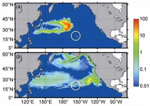
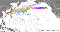
Image above: Simulation of distribution of Cesium 137 nuclear contamination spreading from Fukushima throughout Pacific at two years (above) and eight years (below). From original article. Note circle added to highlight Hawaii.
Nuclear contaminants at the surface will move eastward in the Pacific as far as 140°W, thereafter dividing into two branches. For the south branch, nuclear contaminants will be transported westward by the equatorial current, and can reach the Philippines after 10 years’ time. In contrast, the north branch will arrive at the American west coast and then migrate to the Bering Sea.
At 200 meter water depth, part of the nuclear materials will move southwestward along with deep ocean circulation, which could potentially reach the east coast of Taiwan. The other part will move to the west coast of America and separate into two branches. One will move northward along the west coast of Alaska, while the other will travel southward to the Hawaiian Islands. […] The physical dispersion model results show that high concentrations of the radioactive isotope cesium-137 (137Cs) will move eastward and reach the central Pacific and west coast of North America in two and eight years, respectively. […]
The radioactive isotope 137Cs, with a half-life of 30.1 years, can negatively affect human life for decades, so the transport and diffusion process of 137Cs should raise concern. […]
Given uncertainty of the volume released into the ocean, one source of leaked nuclear materials was idealized at a unit per second in the ocean model, and would be automatically shut off one month later. The forecast of the 137Cs distribution trend is shown in Figure 6. Because of the lack of space, only the distributions of 137Cs in the 2nd and 8th year are shown.
[…] contaminants on the northern side of the Kuroshio Extension diffuse northeastward with the North Pacific Current, and approach the American West Coast in five years. For the south branch, 137Cs will be transported southwestward. [...] After reaching the west coast of North America, 137Cs will be transported southward and northward by coastal currents, affecting that entire coast, including the Bering Sea, but at low concentration. The peak concentration is located east of the Hawaiian Islands and decreases (Figure 6(b)). [...]
[...] The peak concentration of 137Cs will move eastward and approach the central North Pacific in two years. The high concentration of 137Cs radioactive isotope will reach the Hawaiian Islands and approach the west coast of North America. [...] The location of peak concentration, east of the Hawaiian Islands, will not change in eight years, but will be a decreasing concentration. The entire North Pacific Ocean north of 15°N will be affected by nuclear contaminants in 10 years. [...]
Simulation of Pacific Ocean impact
By Dr. Changsheng Chen for University of Massachusetts -
(http://fvcom.smast.umassd.edu/research_projects/FVCOM_Tsunami/)
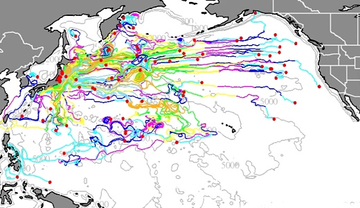
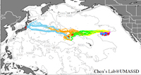
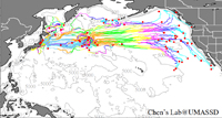
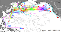
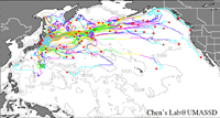
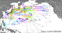
Image above: Still from GIF animation below that simulates the distribution of Ceseum 137 nuclear contamination spreading from a depth of 1200 meters below ocean surface from Fukushima, Japan.
The amount of radiation released in the nuclear accident has threatened the coastal environment with potential impacts on the Pacific Ocean. An international research team was established with the aim of [...] assessing the impact of radionuclides on the surrounding countries around the Pacific. [...] The ocean model used for this activity is the global-coastal nested FVCOM model system. FVCOM is an unstructured grid Finite Volume Community Ocean Model (FVCOM) [...] At 50 m, particles spread over a large region and reach the western US coast after 5 years. [...] At 200 m, particles stay in the narrow region and move eastward.
[IB Publisher's note: for complete report click on link above.]
March 11 2011 was a tragic day for Japan and the world. The earthquake in Tohoku, Japan caused a tsunami, and the resulting tsunami-induced inundation has placed Japan into crisis. The amount of radiation released in the nuclear accident has threatened the coastal environment with potential impacts on the Pacific Ocean.
We would like to share preliminary results of our particle tracer-tracking experiments. We welcome any comments and suggestions. If anyone is interested in working together with this team on this problem, please contact Dr. Chen at c1chen@umassd.edu (or phone: 508-910-6388).
Particle tracer tracking experiment
Variable depth tracking with initial releases of particles at 0 m, 50 m, 100 m, 200 m, 400 m, 600 m, 800 m and 1200 m.
One-hundred neutral buoyant water particles were released at each depth at 00:00 GMT March 12, 2011 and tracked in the three-dimensional flow field including the vertical motion.
The results suggest that radionuclides in the deep water could be upwelled to the upper water column and then disperse over a broad wide region including the East China Sea and Japan Sea as well as the Bering Sea.
.
[IB Publisher's note: Different simulations often use different criteria to model behavior, so the results are not identical. From the simulations done to date it would seem that no Pacific shore will be save from Fukushima nuclear material, but many point to the west coast of North America getting the worst of it - worse than Hawaii, although we will be impacted].
By Hui Wang on 10 December 2013 in Chinese Science Bulletin -
(http://link.springer.com/article/10.1007%2Fs11434-012-5171-6#page-1)
[IB Publisher's note: Below are brief samples from study, To see complete report (and for PDF) click on link above.]
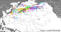
Image above: Simulation of distribution of Cesium 137 nuclear contamination spreading from Fukushima throughout Pacific at two years (above) and eight years (below). From original article. Note circle added to highlight Hawaii.
Nuclear contaminants at the surface will move eastward in the Pacific as far as 140°W, thereafter dividing into two branches. For the south branch, nuclear contaminants will be transported westward by the equatorial current, and can reach the Philippines after 10 years’ time. In contrast, the north branch will arrive at the American west coast and then migrate to the Bering Sea.
At 200 meter water depth, part of the nuclear materials will move southwestward along with deep ocean circulation, which could potentially reach the east coast of Taiwan. The other part will move to the west coast of America and separate into two branches. One will move northward along the west coast of Alaska, while the other will travel southward to the Hawaiian Islands. […] The physical dispersion model results show that high concentrations of the radioactive isotope cesium-137 (137Cs) will move eastward and reach the central Pacific and west coast of North America in two and eight years, respectively. […]
The radioactive isotope 137Cs, with a half-life of 30.1 years, can negatively affect human life for decades, so the transport and diffusion process of 137Cs should raise concern. […]
Given uncertainty of the volume released into the ocean, one source of leaked nuclear materials was idealized at a unit per second in the ocean model, and would be automatically shut off one month later. The forecast of the 137Cs distribution trend is shown in Figure 6. Because of the lack of space, only the distributions of 137Cs in the 2nd and 8th year are shown.
[…] contaminants on the northern side of the Kuroshio Extension diffuse northeastward with the North Pacific Current, and approach the American West Coast in five years. For the south branch, 137Cs will be transported southwestward. [...] After reaching the west coast of North America, 137Cs will be transported southward and northward by coastal currents, affecting that entire coast, including the Bering Sea, but at low concentration. The peak concentration is located east of the Hawaiian Islands and decreases (Figure 6(b)). [...]
[...] The peak concentration of 137Cs will move eastward and approach the central North Pacific in two years. The high concentration of 137Cs radioactive isotope will reach the Hawaiian Islands and approach the west coast of North America. [...] The location of peak concentration, east of the Hawaiian Islands, will not change in eight years, but will be a decreasing concentration. The entire North Pacific Ocean north of 15°N will be affected by nuclear contaminants in 10 years. [...]
Simulation of Pacific Ocean impact
By Dr. Changsheng Chen for University of Massachusetts -
(http://fvcom.smast.umassd.edu/research_projects/FVCOM_Tsunami/)
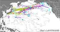
Image above: Still from GIF animation below that simulates the distribution of Ceseum 137 nuclear contamination spreading from a depth of 1200 meters below ocean surface from Fukushima, Japan.
The amount of radiation released in the nuclear accident has threatened the coastal environment with potential impacts on the Pacific Ocean. An international research team was established with the aim of [...] assessing the impact of radionuclides on the surrounding countries around the Pacific. [...] The ocean model used for this activity is the global-coastal nested FVCOM model system. FVCOM is an unstructured grid Finite Volume Community Ocean Model (FVCOM) [...] At 50 m, particles spread over a large region and reach the western US coast after 5 years. [...] At 200 m, particles stay in the narrow region and move eastward.
[IB Publisher's note: for complete report click on link above.]
March 11 2011 was a tragic day for Japan and the world. The earthquake in Tohoku, Japan caused a tsunami, and the resulting tsunami-induced inundation has placed Japan into crisis. The amount of radiation released in the nuclear accident has threatened the coastal environment with potential impacts on the Pacific Ocean.
An international research team was established with the aim of studying the mechanism of the tsunami, simulating the inundation, and assessing the impact of radionuclides on the surrounding countries around the Pacific.
The team members include Dr. Changsheng Chen (Physical Oceanographer), Dr. Zhigang Lai (Physical Oceanographer), and Ms. Huichan Lin (Physical Oceanographer) at University of Massachusetts-Dartmouth (UMASSD)-USA, Dr. Robert C. Beardsley(Physical Oceanographer), Dr. Jian Lin (Geologist) and Dr. Rubao Ji (Biologist) at Woods Hole Oceanographic Institution (WHOI)-USA, Dr. Jun Sasaki at Yokohama National University-Japan and Dr. Chunyan Li (Physical Oceanographer) at Louisiana State University.
The ocean model used for this activity is the global-coastal nested FVCOM model system. FVCOM is an unstructured grid Finite Volume Community Ocean Model (FVCOM) developed originally by Chen et al. (2003) and is being upgraded by the UMASSD-WHOI joint FVCOM development team (Chen et al., 2006a,b). Dr. Sasaki successfully applied FVCOM to simulate the 2004 tsunami and inundation in Banda Aceh in the Indian Ocean.
We would like to share preliminary results of our particle tracer-tracking experiments. We welcome any comments and suggestions. If anyone is interested in working together with this team on this problem, please contact Dr. Chen at c1chen@umassd.edu (or phone: 508-910-6388).
Particle tracer tracking experiment
Variable depth tracking with initial releases of particles at 0 m, 50 m, 100 m, 200 m, 400 m, 600 m, 800 m and 1200 m.
One-hundred neutral buoyant water particles were released at each depth at 00:00 GMT March 12, 2011 and tracked in the three-dimensional flow field including the vertical motion.
The results suggest that radionuclides in the deep water could be upwelled to the upper water column and then disperse over a broad wide region including the East China Sea and Japan Sea as well as the Bering Sea.
3 comments :
It is my hope that anyone who wants to do something to help render the nuclear materials at Dai'ichi power plant's reactors (4) will get in touch with the folks at Morningstar Applied Physics as they have a nuclear remediation tech to render the radioactive materials inert, but they need public pressure built up globally to force the idiots in Tokyo to deploy this system to safely dismantle the plant's reactors and storage pools.
good job copying and pasting this from enenews
Aloha Anonymous,
ENENews is a great place to begin reading coverage of Fukushima disaster.
IB Publisher
Post a Comment