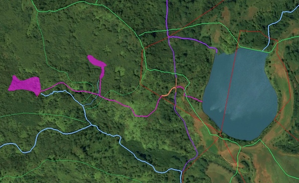
 This image above is a detail of a screen shot from GoogleEarth of Kaloko Reservoir area. Click to enlarge.
I used these applications to with GIS elements to see where and how water could be diverted from Moloaa Stream to Kaloko Reservoir.
LEGEND:
• Red lines are property lines
• Green medium lines are ahupuaa boundaries
• Green thin lines are Moloaa tributary watershed lines
• Blue big thing is Kaloko Reservoir
• Blue medium line are natural stream courses (Kaluaa lower-left, Wailapa upper-right)
• Blue thin line is the unnamed Kaluaa tributary course
• Purple lines are existing permitted ditches serving Kaloko Reservoir
• Pink lines and areas are diversions from Kaluaa Stream (tributary of Moloaa Stream)
• Orange line is diversion catchment system at edge of state land
My first use of this technique is to try to resolve the reports of Moloaa Stream Diversion provided by Hope Kallai. Her information included diagrams, and verbal descriptions of how public water has been diverted from state land and onto private property owned and/or controlled by James Pflueger and into the Kaloko Reservoir.
This meant taking what GIS data tells us about property boundaries, stream locations, roads, ahupuaa boundaries and the like and bringing it to GoogleEarth for a 3D modelling.
Combining GoogleEarth with GIS data allowed me to run some hypothetical possibilities that conformed to the descriptions of how a diversion of water from the Moloaa Stream Ahupuaa and into Pilaa Ahupuaa could be accomplished. Note that Pilaa Ahupuaa includes Wailapa Stream... the one that drowned eight people in a flood in March of 2006.
It must be noted that there is little, if any, photographic evidence in the GoogleEarth images to confirm any diversion ditch locations. That can partially be explained by the scale of a narrow ditch, with some tree cover, and low resolution photography, etc. But that does not fully explain why photographic evidence is so lacking.
Reports do describe at least three underground tunnels involved in the diversion effort. Certainly, someone with a plan to steal so much water would like it to be as unobtrusive as possible. In any case, with a general idea of what to look for, photographic evidence should determine quickly if this is just a hypothesis.
The Kaloko Reservoir is built into a natural puu (geological cone). In Hawaii puus are often natural repositories of fresh water. Puus often line up in strings, like pearls on a necklace. Above Kaloko lies such a string. These upper puus are part of the watershed for the Kaluaa Stream.
My modeling suggests that about half the water from Kaluaa Stream may have been diverted by two takes. One on the south west fork of Kaluaa stream at about 875 feet above sea level and another on a tributary (with no known name) to the Kaluaa that is closer to Kaloko at 880 feet above sea level.
The course of the hypothetical diversion falls at about a 2% slope continuosly to the border of M. N. Lucas Trust Land (Pflueger is trustee). It then passes out of Moloaa Ahupuaa as it brought into a gate with access to the Kaloko Reservoir or into an overflow ditch which leads back to Moloaa Stream.
You can load this 3D data into GoogleEarth. Begin by...
1) Download the file 090522diversion.kmz at out FTP site here.
2) Download file may have to be unzipped (and may have name doc.kml)
3) Open GoogleEarth.
4) Set GoogleEarth 3D terrain "ON" (I used a height exaggeration ratio of 2.5/1).
5) Next import 090522diversion file download into GoogleEarth.
6) GoogleEarth temporary place folder should have "Moloaa Diversion.kmz"
7) Inside you can switch on/off, select, and zoom to diversion elements.
If you have any information that would add to or correct this hypothesis, please let us know.
see also:
Island Breath: Moloaa Stream must be restored 5/15/09
This image above is a detail of a screen shot from GoogleEarth of Kaloko Reservoir area. Click to enlarge.
I used these applications to with GIS elements to see where and how water could be diverted from Moloaa Stream to Kaloko Reservoir.
LEGEND:
• Red lines are property lines
• Green medium lines are ahupuaa boundaries
• Green thin lines are Moloaa tributary watershed lines
• Blue big thing is Kaloko Reservoir
• Blue medium line are natural stream courses (Kaluaa lower-left, Wailapa upper-right)
• Blue thin line is the unnamed Kaluaa tributary course
• Purple lines are existing permitted ditches serving Kaloko Reservoir
• Pink lines and areas are diversions from Kaluaa Stream (tributary of Moloaa Stream)
• Orange line is diversion catchment system at edge of state land
My first use of this technique is to try to resolve the reports of Moloaa Stream Diversion provided by Hope Kallai. Her information included diagrams, and verbal descriptions of how public water has been diverted from state land and onto private property owned and/or controlled by James Pflueger and into the Kaloko Reservoir.
This meant taking what GIS data tells us about property boundaries, stream locations, roads, ahupuaa boundaries and the like and bringing it to GoogleEarth for a 3D modelling.
Combining GoogleEarth with GIS data allowed me to run some hypothetical possibilities that conformed to the descriptions of how a diversion of water from the Moloaa Stream Ahupuaa and into Pilaa Ahupuaa could be accomplished. Note that Pilaa Ahupuaa includes Wailapa Stream... the one that drowned eight people in a flood in March of 2006.
It must be noted that there is little, if any, photographic evidence in the GoogleEarth images to confirm any diversion ditch locations. That can partially be explained by the scale of a narrow ditch, with some tree cover, and low resolution photography, etc. But that does not fully explain why photographic evidence is so lacking.
Reports do describe at least three underground tunnels involved in the diversion effort. Certainly, someone with a plan to steal so much water would like it to be as unobtrusive as possible. In any case, with a general idea of what to look for, photographic evidence should determine quickly if this is just a hypothesis.
The Kaloko Reservoir is built into a natural puu (geological cone). In Hawaii puus are often natural repositories of fresh water. Puus often line up in strings, like pearls on a necklace. Above Kaloko lies such a string. These upper puus are part of the watershed for the Kaluaa Stream.
My modeling suggests that about half the water from Kaluaa Stream may have been diverted by two takes. One on the south west fork of Kaluaa stream at about 875 feet above sea level and another on a tributary (with no known name) to the Kaluaa that is closer to Kaloko at 880 feet above sea level.
The course of the hypothetical diversion falls at about a 2% slope continuosly to the border of M. N. Lucas Trust Land (Pflueger is trustee). It then passes out of Moloaa Ahupuaa as it brought into a gate with access to the Kaloko Reservoir or into an overflow ditch which leads back to Moloaa Stream.
You can load this 3D data into GoogleEarth. Begin by...
1) Download the file 090522diversion.kmz at out FTP site here.
2) Download file may have to be unzipped (and may have name doc.kml)
3) Open GoogleEarth.
4) Set GoogleEarth 3D terrain "ON" (I used a height exaggeration ratio of 2.5/1).
5) Next import 090522diversion file download into GoogleEarth.
6) GoogleEarth temporary place folder should have "Moloaa Diversion.kmz"
7) Inside you can switch on/off, select, and zoom to diversion elements.
If you have any information that would add to or correct this hypothesis, please let us know.
see also:
Island Breath: Moloaa Stream must be restored 5/15/09
Moloaa Diversion Forensics
SUBHEAD: Using GoogleEarth as a basic GIS program one can play geographical detective.
By Juan Wilson on 22 May 2009 for Island Breath -
(http://islandbreath.blogspot.com/2009/05/moloaa-diversion-forensics.html)
I have been using a technical illustration program called Canvas since 1993. It was originally designed for technical illustration. Canvas uses features of desktop publishing and combines bitmap images (i.e. jpgs etc.) and vectors (polygons etc.). I've used the program for architectural drafting, graphic presentation, desktop publishing, illustration and, most recently, map-making (GIS, geo-tiffs, etc.). In the last few weeks I've been combining Canvas use with GoogleEarth to create 3D geographic models.
This image above is a detail of a screen shot from GoogleEarth of Kaloko Reservoir area. Click to enlarge.
I used these applications to with GIS elements to see where and how water could be diverted from Moloaa Stream to Kaloko Reservoir.
LEGEND:
• Red lines are property lines
• Green medium lines are ahupuaa boundaries
• Green thin lines are Moloaa tributary watershed lines
• Blue big thing is Kaloko Reservoir
• Blue medium line are natural stream courses (Kaluaa lower-left, Wailapa upper-right)
• Blue thin line is the unnamed Kaluaa tributary course
• Purple lines are existing permitted ditches serving Kaloko Reservoir
• Pink lines and areas are diversions from Kaluaa Stream (tributary of Moloaa Stream)
• Orange line is diversion catchment system at edge of state land
My first use of this technique is to try to resolve the reports of Moloaa Stream Diversion provided by Hope Kallai. Her information included diagrams, and verbal descriptions of how public water has been diverted from state land and onto private property owned and/or controlled by James Pflueger and into the Kaloko Reservoir.
This meant taking what GIS data tells us about property boundaries, stream locations, roads, ahupuaa boundaries and the like and bringing it to GoogleEarth for a 3D modelling.
Combining GoogleEarth with GIS data allowed me to run some hypothetical possibilities that conformed to the descriptions of how a diversion of water from the Moloaa Stream Ahupuaa and into Pilaa Ahupuaa could be accomplished. Note that Pilaa Ahupuaa includes Wailapa Stream... the one that drowned eight people in a flood in March of 2006.
It must be noted that there is little, if any, photographic evidence in the GoogleEarth images to confirm any diversion ditch locations. That can partially be explained by the scale of a narrow ditch, with some tree cover, and low resolution photography, etc. But that does not fully explain why photographic evidence is so lacking.
Reports do describe at least three underground tunnels involved in the diversion effort. Certainly, someone with a plan to steal so much water would like it to be as unobtrusive as possible. In any case, with a general idea of what to look for, photographic evidence should determine quickly if this is just a hypothesis.
The Kaloko Reservoir is built into a natural puu (geological cone). In Hawaii puus are often natural repositories of fresh water. Puus often line up in strings, like pearls on a necklace. Above Kaloko lies such a string. These upper puus are part of the watershed for the Kaluaa Stream.
My modeling suggests that about half the water from Kaluaa Stream may have been diverted by two takes. One on the south west fork of Kaluaa stream at about 875 feet above sea level and another on a tributary (with no known name) to the Kaluaa that is closer to Kaloko at 880 feet above sea level.
The course of the hypothetical diversion falls at about a 2% slope continuosly to the border of M. N. Lucas Trust Land (Pflueger is trustee). It then passes out of Moloaa Ahupuaa as it brought into a gate with access to the Kaloko Reservoir or into an overflow ditch which leads back to Moloaa Stream.
You can load this 3D data into GoogleEarth. Begin by...
1) Download the file 090522diversion.kmz at out FTP site here.
2) Download file may have to be unzipped (and may have name doc.kml)
3) Open GoogleEarth.
4) Set GoogleEarth 3D terrain "ON" (I used a height exaggeration ratio of 2.5/1).
5) Next import 090522diversion file download into GoogleEarth.
6) GoogleEarth temporary place folder should have "Moloaa Diversion.kmz"
7) Inside you can switch on/off, select, and zoom to diversion elements.
If you have any information that would add to or correct this hypothesis, please let us know.
see also:
Island Breath: Moloaa Stream must be restored 5/15/09
No comments :
Post a Comment